 W
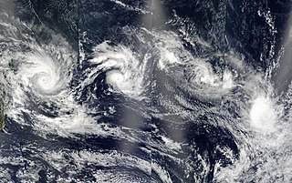
WDuring 2003, tropical cyclones formed within seven different tropical cyclone basins, located within various parts of the Atlantic, Pacific and Indian Oceans. During the year, a total of 129 systems formed with 85 of these developing further and were named by the responsible warning centre. The strongest tropical cyclone of the year was Cyclone Inigo, which was estimated to have a minimum barometric pressure of 900 hPa (26.58 inHg) and was tied with Cyclone Gwenda for being the most intense recorded cyclone in the Australian region in terms of pressure, with the possible exception of Cyclone Mahina.
 W
WThe 2003 Atlantic hurricane season was an extremely active Atlantic hurricane season with tropical activity before and after the official bounds of the season—the first such occurrence since the 1954 season. The season produced 21 tropical cyclones, of which 16 developed into named storms; seven cyclones attained hurricane status, of which three reached major hurricane status. With sixteen storms, the season was tied for the fith-most active Atlantic hurricane season on record, although it has since dropped down to become the seventh most active season. The strongest hurricane of the season was Hurricane Isabel, which reached Category 5 status on the Saffir–Simpson hurricane scale northeast of the Lesser Antilles; Isabel later struck North Carolina as a Category 2 hurricane, causing $3.6 billion in damage and a total of 51 deaths across the Mid-Atlantic region of the United States.
 W
WThe 2002–03 Australian region cyclone season included Cyclone Inigo, which tied with Cyclone Gwenda in 1999 as the most intense tropical cyclone on record in the Australian basin. It began on 1 November 2002 and ended on 30 April 2003. The regional tropical cyclone operational plan also defines a tropical cyclone year separately from a tropical cyclone season, which runs from 1 July 2002 to 30 June 2003. These dates conventionally delimit the period of each year when most tropical cyclones form in the Australian region, which is defined as in the southern hemisphere between 90°E and 180°E. The season's ten tropical depressions existed within these dates, with the first, designated as Tropical Cyclone 07S, entering the basin on 27 December 2002. The last system, Cyclone Epi, dissipated on 6 June 2003. Tropical cyclones in this area were monitored by four Tropical Cyclone Warning Centres (TCWCs): the Australian Bureau of Meteorology (BOM) in Perth, Darwin, and Brisbane and one in Port Moresby, Papua New Guinea.
 W
WThe 2003–04 Australian region cyclone season was a slightly below average tropical cyclone season. It began on 1 November 2003 and ended on 30 April 2004. The regional tropical cyclone operational plan also defines a tropical cyclone year separately from a tropical cyclone season, which runs from 1 July 2003 to 30 June 2004.
 W
WThe 2003 Pacific hurricane season was the first season to feature no major hurricanes – storms of Category 3 intensity or higher – since 1977. It produced an unusually large number of tropical cyclones which affected Mexico. The most notable cyclones during the year were Hurricanes Ignacio and Marty, which killed 2 and 12 people in Mexico, respectively, and were collectively responsible for about US$1 billion in damage. Three other Pacific storms, two of which were hurricanes, and three Atlantic storms also had a direct impact on Mexico. The only other significant storm of the season was Hurricane Jimena, which passed just to the south of Hawaii, the first storm to directly threaten Hawaii for several years.
 W
WThe 2003 Pacific typhoon season was a slightly below average yearlong period of tropical cyclogenesis exhibiting the development of 45 tropical depressions, of which 21 became named storms; of those, 14 became typhoons. Though every month with the exception of February and March featured tropical activity, most storms developed from May through October. During the season, tropical cyclones affected the Philippines, Japan, China, the Korean Peninsula, Indochina, and various islands in the western Pacific.
 W
WThe 2002–03 South Pacific cyclone season was the most active and longest tropical cyclone season since 1997–98, with ten tropical cyclones occurring within the South Pacific basin between 160°E and 120°W. The season started earlier than normal, with two systems developing before the official start of the season on November 1, 2002, while the final system dissipated on June 9, 2003, after the season had officially ended on April 30. During the season, tropical cyclones were officially monitored by the Regional Specialized Meteorological Centre (RSMC) in Nadi, Fiji and the Tropical Cyclone Warning Centres in Brisbane, Australia and Wellington, New Zealand. The United States Armed Forces through the Joint Typhoon Warning Center (JTWC), also monitored the basin and issued unofficial warnings for American interests. RSMC Nadi attaches a number and an F suffix to tropical disturbances that occur within the basin, while the JTWC designates significant tropical cyclones with a number and a P suffix. RSMC Nadi, TCWC Wellington and TCWC Brisbane all use the Australian Tropical Cyclone Intensity Scale and estimate windspeeds over a ten-minute period, while the JTWC estimates sustained winds over a one-minute period, which are subsequently compared to the Saffir–Simpson Hurricane Scale (SSHS).
 W
WThe 2003–04 South Pacific cyclone season was a below-average season with only three tropical cyclones occurring within the South Pacific to the east of 160°E. The season officially ran from November 1, 2003 to April 30, 2004 with the first disturbance of the season forming on December 4 and the last disturbance dissipating on April 23. This is the period of the year when most tropical cyclones form within the South Pacific Ocean.
 W
WIn May 2003, a tropical cyclone officially called Very Severe Cyclonic Storm BOB 01 produced the worst flooding in Sri Lanka in 56 years. The first storm of the 2003 North Indian Ocean cyclone season, it developed over the Bay of Bengal on May 10. Favorable environmental conditions allowed the system to intensify steadily while moving northwestward. The storm reached peak maximum sustained winds of 140 km/h (85 mph) on May 13, making it a very severe cyclonic storm according to the India Meteorological Department (IMD), which is the official Regional Specialized Meteorological Center for the basin. The cyclone drifted north over the central Bay of Bengal, gradually weakening due to heightened wind shear. Turning eastward, the storm deteriorated to a deep depression on May 16 before it curved northeastward and re-intensified into a cyclonic storm. It came ashore in western Myanmar and dissipated over land the following day.
 W
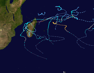
WThe 2002–03 South-West Indian Ocean cyclone season was one of the longest lasting and the third-most active season in the South-West Indian Ocean. Storms during the season impacted the Mascarene Islands, Seychelles, Madagascar, and countries in southeastern Africa. The season began early when an unnamed tropical storm struck Seychelles in September, becoming the most damaging storm there in 50 years. The next system, Atang, was the first named storm of the season, but was only a tropical depression; it was named due to the threat to an outer island of Mauritius. Atang later struck Tanzania in a climatologically unusual area in November, resulting in unconfirmed deaths of fishermen. The first named storm to reach tropical storm intensity was Boura, which brushed the Mascarene Islands with gusty winds and rainfall. In December, Cyclone Crystal threatened to strike Mauritius but instead veered eastward, and later, Tropical Storm Delfina lasted from late December through early January 2003. Delfina damaged or destroyed thousands of houses in Mozambique and Malawi, killing 54 people.
 W
WThe 2003–04 South-West Indian Ocean cyclone season featured the most intense tropical cyclone in the South-West Indian Ocean, Cyclone Gafilo, as well as nine other named storms. Tropical activity began on September 28 when Moderate Tropical Storm Abaimba formed at a low latitude. Activity continued until late May, following Severe Tropical Storm Juba, which marked the third year in a row that a storm formed in May. The final disturbance, one of sixteen, dissipated on May 24. Activity was near average, and the season was one of the longest on record.
 W
WSevere Tropical Cyclone Ami was one of the worst cyclones to affect Fiji. The system was the third cyclone and the second severe tropical cyclone of the 2002–03 South Pacific cyclone season. Cyclone Ami developed from a low-pressure area east of Tuvalu on January 12. Originally, the storm moved slowly towards the southwest early in its existence. Influenced by an upper-level trough, Ami slowed and began moving towards the south and then southeast. The cyclone attained severe tropical cyclone intensity on January 13. Ami made its first landfall at Vanua Levu, before subsequently making another landfall on Taveuni. Still intensifying, Ami reached peak intensity as an equivalent Category 3 cyclone on the Australian and Fiji cyclone scales on January 14. Accelerating to the southeast, the cyclone began to cross over cool sea surface temperatures and encountered wind shear. Ami transitioned into an extratropical cyclone the day after.
 W
WTropical Storm Ana was the first of two named tropical cyclones, along with Tropical Storm Arlene in 2017, on record in the North Atlantic basin to exist in the month of April. The first tropical cyclone of the 2003 season, it developed as a subtropical cyclone from a non-tropical low on April 20 to the west of Bermuda. It tracked east-southeastward and organized, and on April 21 it transitioned into a tropical cyclone with peak winds of 60 mph (95 km/h). Tropical Storm Ana turned east-northeastward, steadily weakening due to wind shear and an approaching cold front, and on April 24 it became an extratropical cyclone. The storm brushed Bermuda with light rain, and the remnants produced precipitation in the Azores and the United Kingdom. Swells generated by the storm capsized a boat along the Florida coastline, causing two fatalities.
 W
WSevere Tropical Cyclone Beni was an intense tropical cyclone that affected four countries, on its 18-day journey across the South Pacific Ocean during January and February 2003. The system originally developed during 19 January as a weak tropical disturbance within the monsoon trough, to the northeast of the Santa Cruz Islands. Over the next few days the system gradually developed further before it was classified as a tropical cyclone and named Beni during 24 January.
 W
WTropical Storm Bill was a tropical storm that affected the Gulf Coast of the United States in the summer of 2003. The second storm of the 2003 Atlantic hurricane season, Bill developed from a tropical wave on June 29 to the north of the Yucatán Peninsula. It slowly organized as it moved northward, and reached a peak of 60 miles per hour (97 km/h) shortly before making landfall in south-central Louisiana. Bill quickly weakened over land, and as it accelerated to the northeast, moisture from the storm, combined with cold air from an approaching cold front, produced an outbreak of 34 tornadoes. Bill became extratropical on July 2, and was absorbed by the cold front later that day.
 W
WTropical Storm Carlos was the first of five tropical cyclones to make landfall during the 2003 Pacific hurricane season. It formed on June 26 from a tropical wave to the south of Mexico. It quickly strengthened as it approached the coast, and early on June 27 Carlos moved ashore in Oaxaca with winds of 65 mph (100 km/h). The storm rapidly deteriorated to a remnant low, which persisted until dissipating on June 29. Carlos brought heavy rainfall to portions of southern Mexico, peaking at 337 mm (13.3 in) in two locations in Guerrero. Throughout its path, the storm damaged about 30,000 houses, with a monetary damage total of 86.7 million pesos. At least nine people were killed throughout the country, seven due to mudslides and two from river flooding; there was also a report of two missing fishermen.
 W
WTropical Cyclone Cilla was a tropical cyclone that brought minor damage to several islands in the South Pacific in January 2003. The fifth cyclone of the 2002–03 South Pacific cyclone season, Cyclone Cilla developed from a monsoon trough on January 26 northwest of Fiji. Initially, Cilla moved east, and due to decreased wind shear, Cilla was able to intensify. On January 28, Cilla reached its peak intensity of 75 km/h (45 mph). After slightly weakening, Cilla briefly re-intensified the next day. However, Cilla transitioned into an extratropical cyclone on January 30. Along its path, Cilla dropped heavy rainfall over islands it passed. During its formative stages, the low dropped heavy rain over Fiji, which had already been affected by Cyclone Ami two weeks prior. Damage in Tonga was mostly limited to vegetation and fruit trees; infrastructural damage was also relatively minor. Cilla also brought moderate rain to American Samoa.
 W
WHurricane Claudette was the third tropical storm and first hurricane of the 2003 Atlantic hurricane season. A fairly long-lived July Atlantic hurricane, Claudette began as a tropical wave in the eastern Caribbean. It moved quickly westward, brushing past the Yucatán Peninsula before moving northwestward through the Gulf of Mexico. Claudette remained a tropical storm until just before making landfall in Port O'Connor, Texas, when it quickly strengthened to a strong Category 1 hurricane on the Saffir-Simpson Hurricane Scale. Forecasting of its path and intensity was uncertain throughout its lifetime, resulting in widespread and often unnecessary preparations along its path.
 W
WSevere Tropical Storm Delfina was a damaging tropical cyclone that affected southeastern Africa in January 2003. The fourth named storm of the 2002–03 South-West Indian Ocean cyclone season, Delfina formed off the northwest coast of Madagascar on December 30, 2002. It quickly intensified while moving westward, becoming a strong tropical storm before hitting northeastern Mozambique on December 31. Delfina weakened while moving inland, and it was no longer classifiable as a tropical cyclone by January 1, 2003. However, its remnants moved across the country and into Malawi, later looping around and crossing back over Mozambique; the remnants of Delfina were last observed on January 9.
 W
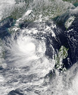
WTyphoon Dujuan, known in the Philippines as Typhoon Onyok, was the strongest tropical cyclone to strike the Pearl River delta since Typhoon Hope in 1979. The 13th storm and 7th typhoon of the 2003 Pacific typhoon season, Dujuan developed on August 27 to the east of Taiwan. It initially moved to the northwest, slowly intensifying into a tropical storm while drawing moisture and rainfall over the Philippines. On the island of Luzon, one person was killed and areas were flooded. Dujuan quickly intensified after turning and moving quicker to the west-northwest, developing an eye. It reached peak winds of 150 km/h (90 mph) on September 1, and shortly thereafter passed just south of Taiwan. There, Dujuan left 590,000 people without power, killed three, and caused NT$200 million in crop damage. While moving through the South China Sea, the typhoon developed concentric eyewalls. Dujuan weakened to severe tropical storm status before making landfall on September 2 in southern China, just east of Hong Kong near Shenzhen, Guangdong. The storm dissipated the next day after causing 40 deaths and ¥2.3 billion in damage. Most of the deaths were in Shenzhen where the storm moved ashore, and the city experienced a near-total power outage.
 W
WSevere Tropical Cyclone Erica of March 2003 was a powerful cyclone that severely affected New Caledonia and was considered the worst to affect the country since Cyclone Beti. The system was the eighth cyclone and the fifth severe tropical cyclone of the 2002-03 South Pacific cyclone season. Cyclone Erica developed from a monsoonal trough on 4 March just off Queensland. Originally, the storm moved slowly towards the east and then north early in its existence. However, increasing wind shear caused the storm to be degenerated into a tropical low. After conditions once again became more favorable for development, the remnants regenerated into a tropical cyclone on 10 March. Steadily intensifying, Erica reached peak intensity on 13 March as a Category 5 equivalent on the Australian intensity scale.
 W
WHurricane Erika was a weak hurricane that struck extreme northeastern Mexico near the Texas-Tamaulipas border in mid-August of the 2003 Atlantic hurricane season. Erika was the eighth tropical cyclone, fifth tropical storm, and third hurricane of the season. At first, the National Hurricane Center (NHC) operationally did not designate it as a hurricane because initial data suggested winds of 70 mph (115 km/h) at Erika's peak intensity. It was not until later data was analyzed that the NHC revised it to Category 1 intensity in the Saffir-Simpson Hurricane Scale. The storm developed from a non-tropical area of low pressure that was tracked for five days before developing in the eastern Gulf of Mexico on August 14. Under the influence of a high pressure system, Erika moved quickly westward and strengthened under favorable conditions. It made landfall as a hurricane on northeastern Mexico on August 16 and rapidly dissipated inland.
 W
WTyphoon Etau, known in the Philippines as Typhoon Kabayan, produced near-record winds and rainfall in Japan in August 2003. The tenth named storm and fifth typhoon of the 2003 Pacific typhoon season, Etau developed on August 2, and gradually intensified while moving to the northwest. Etau formed an eye and became a large storm by the time it approached Okinawa on August 7. The typhoon attained peak winds of 155 km/h (100 mph) before weakening slightly while turning to the northeast. Etau made landfall on the Japanese island of Shikoku on August 8, and later moved across portions of Honshu and Hokkaido. After weakening to tropical storm status, the cyclone became extratropical on August 9 and dissipated three days later.
 W
WHurricane Fabian was a powerful Cape Verde hurricane that hit Bermuda in early September during the 2003 Atlantic hurricane season. It was the sixth named storm, fourth hurricane, and first major hurricane of the season, developed from a tropical wave in the tropical Atlantic Ocean on August 25. It moved west-northwestward under the influence of the subtropical ridge to its north, and steadily strengthened in an area of warm water temperatures and light wind shear. The hurricane attained a peak intensity of 145 mph (230 km/h) on September 1, and it slowly weakened as it turned northward. On September 5, Fabian made a direct hit on Bermuda with wind speeds of over 120 mph (195 km/h). After passing the island, the hurricane turned to the northeast, and became extratropical on September 8, before dissipating two days later.
 W
WTropical Storm Grace was a weak tropical storm that struck Texas in the 2003 Atlantic hurricane season. The eleventh tropical depression and the seventh tropical storm of the season, Grace was also the weakest storm of the season. On August 30 the storm developed from a long-track tropical wave in the western Gulf of Mexico. Grace remained disorganized throughout its lifetime due to an upper level low to its west. The weak storm moved northwestward and made landfall on southeastern Texas. Grace quickly weakened over land, and dissipated on September 2 as it merged into a cold front.
 W
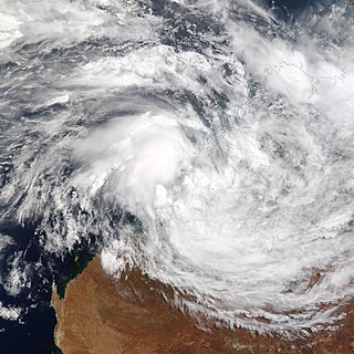
WCyclone Graham of the 2002–03 Australian region cyclone season was a weak tropical storm that affected Australia during late February and early March 2003. Graham originated from an area of convection that emerged onto water after sitting over Australia on 23 February. The interaction with a monsoon trough formed an area of low pressure that developed into Tropical Cyclone Graham on 27 February. The storm moved slowly to the east-southeast, and after turning to the south it peaked as a tropical storm and made landfall on Western Australia the next day. The cyclone weakened as it moved inland, and dissipated on 1 March. The storm dropped heavy rainfall and caused high winds, which produced flooding and downed trees. One fatality occurred, though no significant damages were reported.
 W
WTropical Storm Henri was a moderate tropical storm that formed in the 2003 Atlantic hurricane season. The eighth storm of the season, Henri was one of six tropical cyclones to hit the United States in the year. Henri formed from a tropical wave in the Gulf of Mexico in early September, and crossed over Florida as a tropical depression. Its remnants later moved into the Mid-Atlantic before dissipating completely.
 W
WSevere Tropical Cyclone Heta was a powerful Category 5 tropical cyclone that caused moderate damage to the islands of Tonga, Niue, and American Samoa during late December 2003 and early January 2004. Heta formed on December 25, 2003; it reached a maximum intensity of 260 km/h (160 mph) and an estimated pressure of 915 hPa before dissipating on January 11, 2004. It was the first tropical cyclone to form in the area of responsibility of the regional specialised meteorological centre (RSMC) at Nadi, Fiji, during the 2003–04 South Pacific cyclone season.
 W
WHurricane Ignacio was the latest-forming first hurricane of a Pacific hurricane season since reliable satellite observation began in 1966. The ninth tropical storm of the 2003 Pacific hurricane season, Ignacio developed out of a tropical wave on August 22 a short distance off the coast of Mexico. It was initially predicted to track out to sea and remain a weak tropical storm, though it unexpectedly organized rapidly to attain peak winds of 105 mph (165 km/h) on August 24 while located a short distance southeast of southern Baja California. Land interaction weakened Ignacio to an 80 mph (130 km/h) hurricane by the time it made landfall near La Paz, and it dissipated on August 27 in the central region of the Baja California peninsula.
 W
WTyphoon Imbudo, known in the Philippines as Typhoon Harurot, was a powerful typhoon that struck the Philippines and southern China in July 2003. The seventh named storm and fourth typhoon of the season, Imbudo formed on July 15 to the east of the Philippines. The storm moved generally west-northward for much of its duration due to a ridge to the north. Favorable conditions allowed Imbudo to intensify, gradually at first before undergoing rapid deepening on July 19. After reaching typhoon status, Imbudo strengthened further to peak 10–minute sustained winds of 165 km/h (105 mph) on July 20. The typhoon made landfall on northern Luzon near peak intensity on July 22, but quickly weakened over land. Once in the South China Sea, Imbudo re-intensified slightly before making its final landfall in southern China near Yangjiang on July 24, dissipating the next day.
 W
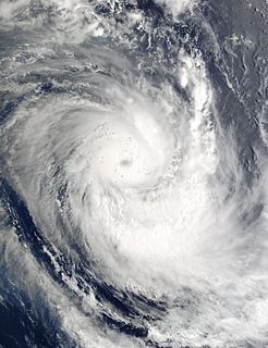
WCyclone Inigo was tied with Cyclone Gwenda for being the most intense recorded cyclone in the Australian region in terms of pressure, with the possible exception of Cyclone Mahina. Inigo developed from a tropical low that crossed eastern Indonesia in late March 2003. Becoming a named tropical cyclone on 1 April, Inigo rapidly intensified as it tracked southwestward, reaching a minimum central pressure of 900 hPa on 4 April. An approaching trough weakened the cyclone and turned it to the southeast, and on 8 April, Inigo dissipated after making landfall on Western Australia, as a minimal tropical storm.
 W
WHurricane Isabel was the strongest Atlantic hurricane since Mitch, and the deadliest, costliest, and most intense hurricane in the 2003 Atlantic hurricane season. The ninth named storm, fifth hurricane, and second major hurricane of the season, Isabel formed near the Cape Verde Islands from a tropical wave on September 6, in the tropical Atlantic Ocean. It moved northwestward, and within an environment of light wind shear and warm waters, it steadily strengthened to reach peak winds of 165 mph (270 km/h) on September 11. After fluctuating in intensity for four days, during which it displayed annular characteristics, Isabel gradually weakened and made landfall on the Outer Banks of North Carolina, with winds of 105 mph (165 km/h) on September 18. Isabel quickly weakened over land and became extratropical over western Pennsylvania on the next day. On September 20, the extratropical remnants of Isabel were absorbed into another system over Eastern Canada.
 W
WIntense Tropical Cyclone Japhet was a damaging tropical cyclone that affected southeast Africa in March 2003. It developed on February 25 near the southwest coast of Madagascar, and initially moved to the northwest before turning to the southwest. With favorable conditions for development, Japhet quickly intensified in the Mozambique Channel, reaching maximum winds of 175 km/h (109 mph), sustained over 10 minutes. After stalling briefly, the cyclone turned to the northwest, weakening slightly before striking Mozambique just south of Vilankulo on March 2. Japhet slowly weakened while progressing inland, dissipating over Zambia on March 6.
 W
WHurricane Jimena was the tenth named storm and second hurricane of the 2003 Pacific hurricane season. Jimena formed on August 28 in the far Eastern Pacific Ocean as a tropical depression and moved westward where it rapidly became a hurricane the following day. The storm moved westward into the Central Pacific Ocean where it became a Category 2 hurricane on the Saffir–Simpson Hurricane Scale. After reaching its peak strength as a Category 2 hurricane, the storm began to weaken due to increasing wind shear. Jimena brushed past the Hawaiian Islands before becoming a tropical depression on September 3. The weakening storm then crossed the international dateline before dissipating on September 5, becoming one of the few storms to cross both 140ºW and International Date Line.
 W
WHurricane Juan was a significant tropical cyclone that heavily damaged parts of Atlantic Canada in late September 2003. Juan is also the first hurricane name and one of two to be requested to be retired by the Meteorological Service of Canada. It was the tenth named storm and the sixth hurricane of the 2003 Atlantic hurricane season. Juan formed southeast of Bermuda on September 24 from a tropical wave that had tracked across the subtropical Atlantic Ocean. It tracked northward and strengthened over the warm waters of the Gulf Stream, reaching Category 2 strength on the Saffir-Simpson hurricane scale on September 27. The hurricane peaked in intensity with sustained winds of 105 mph (165 km/h) that same day, losing some strength as it raced over cooler waters toward the coast of Nova Scotia. Juan made landfall between Shad Bay and Prospect in the Halifax Regional Municipality early on September 29 as a Category 2 hurricane with winds of 100 mph (160 km/h). Juan retained hurricane strength while crossing Nova Scotia from south to north, though it weakened to a Category 1 storm over Prince Edward Island. It was absorbed by another extratropical low later on September 29 near Anticosti Island in the northern Gulf of Saint Lawrence.
 W
WIntense Tropical Cyclone Kalunde was the strongest storm of the 2002–03 South-West Indian Ocean cyclone season. The eleventh named storm and sixth cyclone of the season, Kalunde formed on March 4 from an area of disturbed weather east-southeast of Diego Garcia. The storm steadily strengthened and attained severe tropical storm intensity on March 6. After starting a phase of rapid deepening, Kalunde attained cyclone intensity the next day. Kalunde attained its peak intensity on March 8, as an intense tropical cyclone. It maintained its peak strength for a day; shortly thereafter, the system began to weaken. After undergoing an eyewall replacement cycle, the storm brushed Rodrigues. Shortly after doing so, Kalunde weakened into a tropical cyclone and later a severe tropical storm. Two days later, on March 16, the cyclone transitioned into an extratropical cyclone and dissipated the next day.
 W
WHurricane Kate was a long-lived and erratic tropical cyclone. It was the eleventh tropical storm, seventh hurricane, and third major hurricane of the 2003 Atlantic hurricane season, Kate developed from a tropical wave in the central tropical Atlantic on September 25. Its unusual track included four major changes in direction. The storm moved northwestward until a weakness in the subtropical ridge forced it eastward. Kate strengthened to a hurricane, turned sharply westward while moving around a mid-level low, and intensified to a 125 mph (205 km/h) major hurricane on October 4. Kate turned sharply northward around the periphery of an anticyclone, weakened, and became extratropical after passing to the east of Newfoundland. The extratropical storm persisted for three days until losing its identity near Scandinavia.
 W
WSevere Tropical Storm Koni, known in the Philippines as Tropical Storm Gilas, caused moderate damage to areas of China and Vietnam in July 2003. The eighth tropical storm in the western Pacific that year, Koni originated from a disturbance situated within the monsoon trough well east of the Philippines on July 15. Tracking westward, intensification was slow and the system remained a tropical depression as it moved across the central Philippines on July 17. Upon moving into the South China Sea, however, conditions allowed for quicker strengthening, and as such the cyclone reached tropical storm status on July 18 before reaching its peak intensity with maximum sustained winds of 110 km/h (70 mph) and a minimum barometric pressure of 975 mbar, making it a severe tropical storm. However, atmospheric conditions began to deteriorate as Koni made landfall on Hainan on July 21, weakening the system. The tropical storm continued to weaken as it moved over the Gulf of Tonkin prior to a final landfall near Hanoi, Vietnam the following day. Tracking inland, the combination of land interaction and wind shear caused Koni to dissipate over Laos on July 23.
 W
WTyphoon Krovanh, known in the Philippines as Typhoon Niña, was a moderate tropical cyclone that caused a swath of damage stretching from the Philippines to Vietnam in August 2003. The fifteenth named storm and sixth typhoon in the western Pacific that year, Krovanh originated from a tropical disturbance within the monsoon trough on August 13. Despite rather favorable conditions, the initial tropical depression did not intensify significantly and degenerated into a remnant low on August 18. However, these remnants were able to reorganize and the system was reclassified as a tropical cyclone a day later. Intensification was rather rapid upon the storm's reformation – the depression reached tropical storm status on August 20 and then typhoon intensity two days later. Shortly after, Krovanh made landfall on Luzon at peak intensity with winds of 120 km/h (75 mph). The typhoon emerged into the South China Sea as a much weaker tropical storm, though it was able to restrengthen over warm waters. Once again at typhoon intensity, Krovanh clipped Haiyan before moving over the Leizhou Peninsula on its way to a final landfall near Cẩm Phả, Vietnam on August 25. Quick weakening due to land interaction occurred as Krovanh moved across northern Vietnam, where the storm met its demise the following day.
 W
WTyphoon Kujira, known in the Philippines as Typhoon Amang, was a long-lived tropical cyclone that lasted for 16 days affected the island nations of Micronesia, Taiwan, and Japan in April 2003, as well as the earliest typhoon in a calendar year to ever make landfall on the latter. Forming from a broad area of disturbed weather as a tropical depression on April 9 well removed from any landmasses, Kujira quickly intensified in its early stages, and was upgraded to a tropical storm just two days after cyclogenesis. Strengthening slowed afterwards, though the storm attained typhoon intensity on April 14. Intensification continued and late on April 15, Kujira reached its peak intensity with winds of 165 km/h (105 mph) and a minimum barometric pressure of 930 mbar. Following peak intensity, Kujira began to track northwest and oscillate in strength, cresting an additional two times in intensity. On April 21, the typhoon was downgraded to tropical storm intensity and began to track erratically for several days east of Taiwan. However, on April 24, Kujira resumed a northward track and begin to weaken, and on April 24 was downgraded to tropical depression strength as it made landfall on Kyushu. Following landfall Kujira transitioned into an extratropical cyclone and continued to persist before these extratropical remnants crossed the International Dateline towards the end of April 2003.
 W
WTropical Storm Larry was the twelfth tropical storm in the 2003 Atlantic hurricane season. It was one of eight storms to impact Mexico from either the Pacific or Atlantic Oceans in the season, a near-record. Larry formed in early October from an extratropical storm in the Bay of Campeche, and reached a peak intensity of 65 mph (100 km/h). Due to weak steering currents, the storm moved southward, which resulted in the storm hitting the Tabasco coastline. The storm was the first Tabascan landfall since Tropical Storm Brenda in 1973.
 W
WSevere Tropical Storm Linfa, known in the Philippines as Tropical Storm Chedeng, brought deadly flooding to areas of the Philippines and Japan in May and June 2003. The fifth named storm within the northwestern Pacific that year, Linfa developed as a tropical depression just off the western coast of Luzon on May 25. The disturbance quickly intensified to reach tropical storm intensity a few hours after cyclogenesis. However, intensification leveled off as Linfa executed a small clockwise loop before a subsequent landfall on Luzon on May 27. Due to land interaction the storm temporarily weakened and decoupled before reforming in the Philippine Sea. Afterwards Linfa began reintensifying and reached its peak intensity on May 29 with maximum sustained winds of 100 km/h (65 mph) and a barometric pressure of 980 mbar. Following its peak the tropical storm began to deteriorate and transitioned into an extratropical cyclone on May 30; these extratropical remnants continued to track northward through Japan before dissipating in the Sea of Okhotsk on June 4.
 W
WTyphoon Lupit, known in the Philippines as Typhoon Yoyoy, destroyed the food supply in several small islands in Yap State in the Federated States of Micronesia (FSM). It formed on November 18, 2003, from the monsoon trough to the west of the Marshall Islands. Early in its duration, it moved generally to the west or west-southwest. On November 21, the depression intensified into Tropical Storm Lupit, the 21st storm named by the Japan Meteorological Agency of the 2003 Pacific typhoon season. Two days later, it strengthened into a typhoon and developed an eye. Lupit later began a prolonged movement to the northwest, during which it passed near several islands in Yap State. The typhoon reached peak intensity on November 26, with peak 10‑minute sustained winds of 185 km/h (115 mph). It later weakened due to increasing wind shear and drier air, and after recurving to the northeast, Lupit became extratropical south of Japan on December 2.
 W
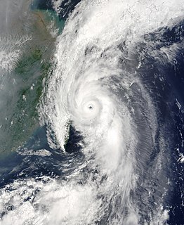
WTyphoon Maemi, known in the Philippines as Typhoon Pogi, was the most powerful typhoon to strike South Korea since record-keeping began in the country in 1904. Maemi formed on September 4, 2003 from a disturbance in a monsoon trough in the western Pacific Ocean. It slowly intensified into Tropical Storm Maemi while moving northwestward, becoming a typhoon on September 8. That day, favorable conditions facilitated more rapid strengthening; the storm developed a well-defined eye and reached peak maximum sustained winds of 195 km/h (120 mph). While near peak intensity, Maemi decelerated and began turning to the north-northeast. Soon after, the eyewall passed over the Japanese island of Miyako-jima on September 10 and produced an air pressure reading of 912 mbar (26.9 inHg), the fourth-lowest recorded in the nation. Due to warm waters, Maemi was able to maintain much of its intensity before it made landfall just west of Busan, South Korea, on September 12. The typhoon became extratropical in the Sea of Japan the next day, although its remnants persisted for several days, lashing northern Japan with strong winds.
 W
WTropical Cyclone Manou was a relatively rare May tropical cyclone that affected southeastern Madagascar. The final named storm of the 2002–03 South-West Indian Ocean cyclone season, Manou formed on May 2 to the southwest of Diego Garcia. It moved generally to the southwest for much of its duration, steered by a ridge to the southeast. Manou affected Saint Brandon and Mauritius with gusty winds. After an initial strengthening phase, the storm weakened but later re-intensified as it approached Madagascar. Manou developed a well-defined eye and reached peak winds only 19 km (12 mi) from the eastern Madagascar coastline. For about 12 hours, the cyclone stalled before turning to the south and weakening. Manou became extratropical on May 10 and dissipated three days later.
 W
WHurricane Marty was the deadliest tropical cyclone of the 2003 Pacific hurricane season. Forming on September 18, it became the 13th tropical storm and fourth hurricane of the year. The storm moved generally northwestward and steadily intensified despite only a marginally favorable environment for development, and became a Category 2 hurricane before making two landfalls on the Baja California peninsula and mainland Mexico.
 W
WTropical Storm Morakot, known in the Philippines as Tropical Storm Juaning, brought significant rainfall to Taiwan before alleviating drought conditions in mainland China in August 2003. The tenth named storm in the western Pacific that year, Morakot spawned from an area of disturbed weather in the Philippine Sea on July 31. Tracking northwest, favorable conditions allowed for the intensification of the system to tropical storm strength on August 2. Morakot reached peak intensity later that day with winds of 85 km/h (50 mph) and a minimum barometric pressure of 992 mbar. This intensity was held for several hours until less conducive atmospheric conditions slightly weakened the system; this was followed by Morakot making landfall on southern Taiwan on August 3. Subsequently, the storm weakened and moved into the Taiwan Strait before making its final landfall near Quanzhou, China the next day. The storm quickly weakened over the Chinese mainland, and dissipated entirely several hours after landfall.
 W
WTyphoon Nepartak, known in the Philippines as Typhoon Weng, was a modest tropical cyclone that struck the central Philippines and the southern China island of Hainan in November 2003. Forming as a tropical depression on November 11 between Yap and Guam, the system moved westward and slowly intensified. It received the name Nepartak midday on November 12 from the Japan Meteorological Agency, becoming the 20th named storm of the 2003 Pacific typhoon season. On November 13, Napartak struck Samar in the Philippines and bisected the island chain. Up to four million people lost power, and transportation ground to a halt; over 5,000 individuals became stranded on ships forced to stay in port during the tropical storm. It was reported that 13 individuals lost their lives to the storm in the Philippines.
 W
WTropical Storm Nicholas was a long-lived tropical storm in October and November of the 2003 Atlantic hurricane season. Forming from a tropical wave on October 13 in the central tropical Atlantic Ocean, Nicholas slowly developed due to moderate levels of wind shear throughout its lifetime. Deep convection slowly organized, and Nicholas attained a peak intensity of 70 mph (110 km/h) on October 17. After moving west-northwestward for much of its lifetime, it turned northward and weakened due to increasing shear. The storm again turned to the west and briefly restrengthened, but after turning again to the north Nicholas transitioned to an extratropical cyclone on October 24. As an extratropical storm, Nicholas executed a large loop to the west, and after moving erratically for a week and organizing into a tropical low, it was absorbed by a non-tropical low. The low continued westward, crossed Florida, and ultimately dissipated over the Gulf Coast of the United States on November 5.
 W
WHurricane Nora was the final of five tropical cyclones to make landfall in the 2003 Pacific hurricane season. The fourteenth named storm and fifth hurricane of the season, Nora developed on October 1 from a tropical wave. It slowly intensified as it moved northwestward, intensifying into a hurricane on October 4. That day, Nora rapidly intensified to its peak of 100 mph (160 km/h), but the larger Hurricane Olaf to its east prevented further strengthening. An approaching trough turned the rapidly weakening system to the east toward Mexico. By October 7, it was downgraded to a tropical depression. Although it no longer met the criteria for being a tropical cyclone, the National Hurricane Center continued issuing advisories due to the cyclone's proximity with land. Nora unexpectedly redeveloped an area of thunderstorms and moved ashore near Mazatlán, Sinaloa on October 9 before dissipating. The depression dropped locally heavy rainfall in western Mexico, but there were no reports of damage. Later, the remnants combined with Olaf and an upper-level low to produce flooding and a tornado in central Texas.
 W
WTropical Storm Odette was a rare off-season tropical storm that affected the Caribbean Sea in early December 2003. The fifteenth named storm of the 2003 Atlantic hurricane season, Odette formed near the coast of Panama a few days after the official end of the Atlantic hurricane season, and ultimately made landfall on the Dominican Republic as a moderate tropical storm, before becoming extratropical on December 7, dissipating two days later.
 W
WHurricane Olaf was a minimal hurricane that impacted Mexico in October 2003. A tropical wave became better organized on October 2 to the south-southeast of Acapulco and developed into a depression the next day. It strengthened into Tropical Storm Olaf six hours after forming. Continued intensification occurred, and Olaf reached its peak strength as a Category 1 hurricane with 75 mph (120 km/h) winds on October 5 and developed a partial eyewall. The storm soon became disorganized and was only a hurricane for six hours, before re-curving towards the Mexican coast. The cyclone made landfall near Manzanillo, Colima, on October 7 and soon dissipated overland. The storm caused severe flooding in the states of Jalisco and Guanajuato. However, no fatalities were reported.
 W
WTyphoon Soudelor, known in the Philippines as Typhoon Egay, was a powerful typhoon that underwent rapid deepening east of Taiwan in the 2003 Pacific typhoon season. It was the sixth named storm by the Japan Meteorological Agency (JMA) of the season, as well as the third typhoon. It formed on June 12 from a disturbance in the monsoon trough, located east of the Philippines. The system moved generally to the northwest after its genesis, gradually intensifying into a tropical storm. While offshore the Philippines, Soudelor dropped heavy rainfall that caused flooding and left thousands homeless. The storm caused $2.46 million in damage, and 12 deaths.
 W
WSevere Tropical Cyclone Zoe was the second-most intense tropical cyclone on record within the Southern Hemisphere and was the strongest tropical cyclone worldwide in 2002. The system was first noted on December 23, 2002 as a tropical depression that had developed, within the South Pacific Convergence Zone to the east of Tuvalu. Over the next couple of days the system moved south-westwards and crossed the International Dateline early on December 25. After this the system became better organized and was declared to be a tropical cyclone and named Zoe later that day. Zoe subsequently rapidly intensified in very favorable conditions as it continued to move west-southwest towards the Solomon Islands. The system subsequently became a Category 5 tropical cyclone on both the Australian tropical cyclone intensity scale and the Saffir-Simpson hurricane wind scale on December 27. The system subsequently affected the Solomon Islands Temotu Province during that day, before it peaked with 10-minute sustained wind speeds of 240 km/h (150 mph). As the system peaked, it performed a small clockwise cyclonic loop within the vicinity of Tikopia island, as a result of the steering flow over the cyclone becoming weak and variable. The system subsequently started to move towards the southeast during December 29, in response to a strengthening steering flow, provided by an upper level trough of low pressure and a baroclinic system near New Caledonia. Over the next few days the system weakened and degenerated into a tropical depression during January 1, 2003. The system was subsequently last noted during January 4, while it was located to the southeast of New Caledonia.