 W
WIn thermodynamics, an adiabatic process is a type of thermodynamic process which occurs without transferring heat or mass between the system and its surroundings. Unlike an isothermal process, an adiabatic process transfers energy to the surroundings only as work. It also conceptually supports the theory used to explain the first law of thermodynamics and is therefore a key thermodynamic concept.
 W
WThe atmosphere of Earth is the layer of gases, commonly known as air, retained by Earth's gravity, surrounding the planet Earth and forming its planetary atmosphere. The atmosphere of Earth protects life on Earth by creating pressure allowing for liquid water to exist on the Earth's surface, absorbing ultraviolet solar radiation, warming the surface through heat retention, and reducing temperature extremes between day and night.
 W
WAtmospheric convection is the result of a parcel-environment instability, or temperature difference layer in the atmosphere. Different lapse rates within dry and moist air masses lead to instability. Mixing of air during the day which expands the height of the planetary boundary layer leads to increased winds, cumulus cloud development, and decreased surface dew points. Moist convection leads to thunderstorm development, which is often responsible for severe weather throughout the world. Special threats from thunderstorms include hail, downbursts, and tornadoes.
 W
WAtmospheric instability is a condition where the Earth's atmosphere is generally considered to be unstable and as a result the weather is subjected to a high degree of variability through distance and time. Atmospheric stability is a measure of the atmosphere's tendency to discourage or deter vertical motion, and vertical motion is directly correlated to different types of weather systems and their severity. In unstable conditions, a lifted thing, such as a parcel of air will be warmer than the surrounding air at altitude. Because it is warmer, it is less dense and is prone to further ascent.
 W
WAtmospheric temperature is a measure of temperature at different levels of the Earth's atmosphere. It is governed by many factors, including incoming solar radiation, humidity and altitude. When discussing surface air temperature, the annual atmospheric temperature range at any geographical location depends largely upon the type of biome, as measured by the Köppen climate classification
 W
WA capping inversion is an elevated inversion layer that caps a convective planetary boundary layer.
 W
WConditional symmetric instability, or CSI, is a form of convective instability in a fluid subject to temperature differences in a uniform rotation frame of reference while it is thermally stable in the vertical and dynamically in the horizontal. The instability in this case develop only in an inclined plane with respect to the two axes mentioned and that is why it can give rise to a so-called "slantwise convection" if the air parcel is almost saturated and moved laterally and vertically in a CSI area. This concept is mainly used in meteorology to explain the mesoscale formation of intense precipitation bands in an otherwise stable region, such as in front of a warm front. The same phenomenon is also applicable to oceanography.
 W
WIn meteorology, convective available potential energy, is the integrated amount of work that the upward (positive) buoyancy force would perform on a given mass of air if it rose vertically through the entire atmosphere. Positive CAPE will cause the air parcel to rise, while negative CAPE will cause the air parcel to sink. Nonzero CAPE is an indicator of atmospheric instability in any given atmospheric sounding, a necessary condition for the development of cumulus and cumulonimbus clouds with attendant severe weather hazards.
 W
WConvective inhibition is a numerical measure in meteorology that indicates the amount of energy that will prevent an air parcel from rising from the surface to the level of free convection.
 W
WIn meteorology, convective instability or stability of an air mass refers to its ability to resist vertical motion. A stable atmosphere makes vertical movement difficult, and small vertical disturbances dampen out and disappear. In an unstable atmosphere, vertical air movements tend to become larger, resulting in turbulent airflow and convective activity. Instability can lead to significant turbulence, extensive vertical clouds, and severe weather such as thunderstorms.
 W
WA degree day is a measure of heating or cooling. Total degree days from an appropriate starting date are used to plan the planting of crops and management of pests and pest control timing. Weekly or monthly degree-day figures may also be used within an energy monitoring and targeting scheme to monitor the heating and cooling costs of climate controlled buildings, while annual figures can be used for estimating future costs.
 W
WThe density altitude is the altitude relative to standard atmospheric conditions at which the air density would be equal to the indicated air density at the place of observation. In other words, the density altitude is the air density given as a height above mean sea level. The density altitude can also be considered to be the pressure altitude adjusted for a non-standard temperature.
 W
WThe dew point is the temperature to which air must be cooled to become saturated with water vapor. When cooled further, the airborne water vapor will condense to form liquid water (dew). When air cools to its dew point through contact with a surface that is colder than the air, water will condense on the surface.
WThe dew point depression (T-Td) is the difference between the temperature and dew point temperature at a certain height in the atmosphere.
 W
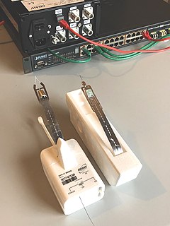
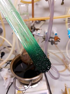
WDewcells, dewcels or dew cell are instruments used for determining the dew point. They consist of a small heating element surrounded by a solution of lithium chloride. As the LiCl absorbs moisture from the air, conduction across the heating element increases, current in it increases, and heat increases, evaporating moisture from the salt solution. At a certain temperature the amount of moisture absorbed by the salt solution equals the amount evaporated (equilibrium).
WThe dry-bulb temperature (DBT) is the temperature of air measured by a thermometer freely exposed to the air, but shielded from radiation and moisture. DBT is the temperature that is usually thought of as air temperature, and it is the true thermodynamic temperature. It indicates the amount of heat in the air and is directly proportional to the mean kinetic energy of the air molecules. Temperature is usually measured in degrees Celsius (°C), kelvins (K), or degrees Fahrenheit (°F).
 W
WAn emagram is one of four thermodynamic diagrams used to display temperature lapse rate and moisture content profiles in the atmosphere. The emagram has axes of temperature (T) and pressure (p). In the emagram, the dry adiabats make an angle of about 45 degrees with the isobars, isotherms are vertical and isopleths of saturation mixing ratio are almost straight and vertical.
 W
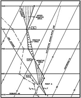
WIn meteorology, the equilibrium level (EL), or level of neutral buoyancy (LNB), or limit of convection (LOC), is the height at which a rising parcel of air is at the same temperature as its environment.
 W
WEvaporation is a type of vaporization that occurs on the surface of a liquid as it changes into the gas phase. The surrounding gas must not be saturated with the evaporating substance. When the molecules of the liquid collide, they transfer energy to each other based on how they collide with each other. When a molecule near the surface absorbs enough energy to overcome the vapor pressure, it will escape and enter the surrounding air as a gas. When evaporation occurs, the energy removed from the vaporized liquid will reduce the temperature of the liquid, resulting in evaporative cooling.
WIn atmospheric sciences, the free convective layer (FCL) is the layer of conditional or potential instability in the troposphere. It is a layer in which rising air can experience positive buoyancy (PBE) so that deep, moist convection (DMC) can occur. On an atmospheric sounding, it is the layer between the level of free convection (LFC) and the equilibrium level (EL). The FCL is important to a variety of convective processes and to severe thunderstorm forecasting.
 W
WFreezing is a phase transition where a liquid turns into a solid when its temperature is lowered below its freezing point. In accordance with the internationally established definition, freezing means the solidification phase change of a liquid or the liquid content of a substance, usually due to cooling.
WThe heat index (HI) is an index that combines air temperature and relative humidity, in shaded areas, to posit a human-perceived equivalent temperature, as how hot it would feel if the humidity were some other value in the shade. The result is also known as the "felt air temperature", "apparent temperature", "real feel" or "feels like". For example, when the temperature is 32 °C (90 °F) with 70% relative humidity, the heat index is 41 °C (106 °F).
 W
WHorizontal convective rolls, also known as horizontal roll vortices or cloud streets, are long rolls of counter-rotating air that are oriented approximately parallel to the ground in the planetary boundary layer. Although horizontal convective rolls, also known as cloud streets, have been clearly seen in satellite photographs for the last 30 years, their development is poorly understood, due to a lack of observational data. From the ground, they appear as rows of cumulus or cumulus-type clouds aligned parallel to the low-level wind. Research has shown these eddies to be significant to the vertical transport of momentum, heat, moisture, and air pollutants within the boundary layer. Cloud streets are usually more or less straight; rarely, cloud streets assume paisley patterns when the wind driving the clouds encounters an obstacle. Those cloud formations are known as von Kármán vortex streets.
 W
WHumidity is the concentration of water vapor present in the air. Water vapor, the gaseous state of water, is generally invisible to the human eye. Humidity indicates the likelihood for precipitation, dew, or fog to be present.
WA humidity indicator card (HIC) is a card on which a moisture-sensitive chemical is impregnated such that it will change color when the indicated relative humidity is exceeded. This has usually been a blotting paper impregnated with cobalt(II) chloride base; Less toxic alternatives include other chemicals such as cobalt-free chloride base and special plastic films.
 W
WA hygrometer is an instrument used to measure the amount of water vapor in air, in soil, or in confined spaces. Humidity measurement instruments usually rely on measurements of some other quantities such as temperature, pressure, mass, a mechanical or electrical change in a substance as moisture is absorbed. By calibration and calculation, these measured quantities can lead to a measurement of humidity. Modern electronic devices use temperature of condensation, or changes in electrical capacitance or resistance to measure humidity differences. The first crude hygrometer was invented by the Italian Renaissance polymath Leonardo da Vinci in 1480 and a more modern version was created by Swiss polymath Johann Heinrich Lambert in 1755. Later, in the year 1783, Swiss physicist and Geologist Horace Bénédict de Saussure invented the first hygrometer using human hair to measure humidity.
 W
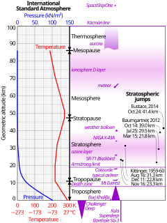
WThe International Standard Atmosphere (ISA) is a static atmospheric model of how the pressure, temperature, density, and viscosity of the Earth's atmosphere change over a wide range of altitudes or elevations. It has been established to provide a common reference for temperature and pressure and consists of tables of values at various altitudes, plus some formulas by which those values were derived. The International Organization for Standardization (ISO) publishes the ISA as an international standard, ISO 2533:1975. Other standards organizations, such as the International Civil Aviation Organization (ICAO) and the United States Government, publish extensions or subsets of the same atmospheric model under their own standards-making authority.
 W
WIn meteorology, an inversion, also known as a temperature inversion, is a deviation from the normal change of an atmospheric property with altitude. It almost always refers to an inversion of the thermal lapse rate. Normally, air temperature decreases with an increase in altitude. During an inversion, warmer air is held above cooler air; the normal temperature profile with altitude is inverted.
 W
WIsentropic analysis in meteorology is a technique to find the vertical and horizontal motion of airmasses during an adiabatic process above the planetary boundary layer. The change of state of air parcels following isentropic surfaces does not involve exchange of heat with the environment. Such an analysis can also evaluate the airmass stability in the vertical dimension and whether an air parcel crossing such a surface will result in convective or stratiform clouds. It is based on the study of weather maps or vertical cross-sections of the potential temperature values in the troposphere.
WIn thermodynamics, an isobaric process is a type of thermodynamic process in which the pressure of the system stays constant: ΔP = 0. The heat transferred to the system does work, but also changes the internal energy (U) of the system. This article uses the physics sign convention for work, where positive work is work done by the system. Using this convention, by the first law of thermodynamics,
WIn thermodynamics, an isothermal process is a type of thermodynamic process in which the temperature of the system remains constant: ΔT = 0. This typically occurs when a system is in contact with an outside thermal reservoir, and the change in the system will occur slowly enough to allow the system to continue to adjust to the temperature of the reservoir through heat exchange. In contrast, an adiabatic process is where a system exchanges no heat with its surroundings (Q = 0).
 W
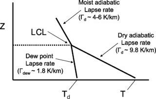
WThe lapse rate is the rate at which an atmospheric variable, normally temperature in Earth's atmosphere, falls with altitude. Lapse rate arises from the word lapse, in the sense of a gradual fall.
WLatent heat is energy released or absorbed, by a body or a thermodynamic system, during a constant-temperature process — usually a first-order phase transition.
WThe level of free convection (LFC) is the altitude in the atmosphere where the temperature of the environment decreases faster than the moist adiabatic lapse rate of a saturated air parcel at the same level.
 W
WThe lifted condensation level or lifting condensation level (LCL) is formally defined as the height at which the relative humidity (RH) of an air parcel will reach 100% with respect to liquid water when it is cooled by dry adiabatic lifting. The RH of air increases when it is cooled, since the amount of water vapor in the air remains constant, while the saturation vapor pressure decreases almost exponentially with decreasing temperature. If the air parcel is lifting further beyond the LCL, water vapor in the air parcel will begin condensing, forming cloud droplets. The LCL is a good approximation of the height of the cloud base which will be observed on days when air is lifted mechanically from the surface to the cloud base.
 W
WThe lifted index (LI) is the temperature difference between the environment Te(p) and an air parcel lifted adiabatically Tp(p) at a given pressure height in the troposphere of the atmosphere, usually 500 hPa (mb). The temperature is measured in Celsius. When the value is positive, the atmosphere is stable and when the value is negative, the atmosphere is unstable.
 W
WA marine layer is an air mass that develops over the surface of a large body of water such as the ocean or large lake in the presence of a temperature inversion. The inversion itself is usually initiated by the cooling effect of the water on the surface layer of an otherwise warm air mass.
 W
WThe melting point of a substance is the temperature at which it changes state from solid to liquid. At the melting point the solid and liquid phase exist in equilibrium. The melting point of a substance depends on pressure and is usually specified at a standard pressure such as 1 atmosphere or 100 kPa.
 W
WThe oceanic or limnological mixed layer is a layer in which active turbulence has homogenized some range of depths. The surface mixed layer is a layer where this turbulence is generated by winds, surface heat fluxes, or processes such as evaporation or sea ice formation which result in an increase in salinity. The atmospheric mixed layer is a zone having nearly constant potential temperature and specific humidity with height. The depth of the atmospheric mixed layer is known as the mixing height. Turbulence typically plays a role in the formation of fluid mixed layers.
 W
WPressure is the force applied perpendicular to the surface of an object per unit area over which that force is distributed. Gauge pressure is the pressure relative to the ambient pressure.
 W
WA radiosonde is a battery-powered telemetry instrument carried into the atmosphere usually by a weather balloon that measures various atmospheric parameters and transmits them by radio to a ground receiver. Modern radiosondes measure or calculate the following variables: altitude, pressure, temperature, relative humidity, wind, cosmic ray readings at high altitude and geographical position (latitude/longitude). Radiosondes measuring ozone concentration are known as ozonesondes.
 W
WA sounding rocket or rocketsonde, sometimes called a research rocket, is an instrument-carrying rocket designed to take measurements and perform scientific experiments during its sub-orbital flight. The rockets are used to carry instruments from 48 to 145 km above the surface of the Earth, the altitude generally between weather balloons and satellites; the maximum altitude for balloons is about 40 km and the minimum for satellites is approximately 121 km. Certain sounding rockets have an apogee between 1,000 and 1,500 km, such as the Black Brant X and XII, which is the maximum apogee of their class. Sounding rockets often use military surplus rocket motors. NASA routinely flies the Terrier Mk 70 boosted Improved Orion, lifting 270–450-kg (600–1,000-pound) payloads into the exoatmospheric region between 97 and 201 km.
WSaturation vapor density (SVD) is a concept closely tied with saturation vapor pressure (SVP). It can be used to calculate exact quantity of water vapor in the air from a relative humidity Given an RH percentage, the density of water in the air is given by RH × SVD = Actual Vapor Density. Alternatively, RH can be found by RH = Actual Vapor Density ∕ SVD. As relative humidity is a dimensionless quantity, vapor density can be stated in units of grams or kilograms per cubic meter.
 W
WA skew-T log-P diagram is one of four thermodynamic diagrams commonly used in weather analysis and forecasting. In 1947, N. Herlofson proposed a modification to the emagram that allows straight, horizontal isobars and provides for a large angle between isotherms and dry adiabats, similar to that in the tephigram. It was thus more suitable for some of the newer analysis techniques being invented by the United States Air Force.
 W
WA Stüve diagram is one of four thermodynamic diagrams commonly used in weather analysis and forecasting. It was developed circa 1927 by the German meteorologist Georg Stüve (1888–1935) and quickly gained widespread acceptance in the United States to plot temperature and dew point data from radiosondes.
 W
WSublimation is the transition of a substance directly from the solid to the gas state, without passing through the liquid state. Sublimation is an endothermic process that occurs at temperatures and pressures below a substance's triple point in its phase diagram, which corresponds to the lowest pressure at which the substance can exist as a liquid. The reverse process of sublimation is deposition or desublimation, in which a substance passes directly from a gas to a solid phase. Sublimation has also been used as a generic term to describe a solid-to-gas transition (sublimation) followed by a gas-to-solid transition (deposition). While vaporization from liquid to gas occurs as evaporation from the surface if it occurs below the boiling point of the liquid, and as boiling with formation of bubbles in the interior of the liquid if it occurs at the boiling point, there is no such distinction for the solid-to-gas transition which always occurs as sublimation from the surface.
 W
WTemperature measurement describes the process of measuring a current local temperature for immediate or later evaluation. Datasets consisting of repeated standardized measurements can be used to assess temperature trends.
 W
WA tephigram is one of four thermodynamic diagrams commonly used in weather analysis and forecasting. The name evolved from the original name "T--gram" to describe the axes of temperature (T) and entropy used to create the plot. Usually, temperature and dew point data from radiosondes are plotted on these diagrams to allow calculations of convective stability or convective available potential energy (CAPE). Wind barbs are often plotted at the side of a tephigram to indicate the winds at different heights.
 W
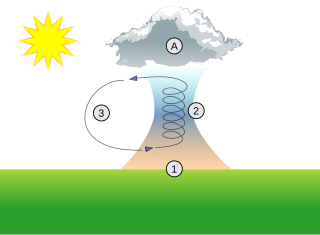
WA thermal column is a column of rising air in the lower altitudes of Earth's atmosphere, a form of atmospheric updraft. Thermals are created by the uneven heating of Earth's surface from solar radiation, and are an example of convection, specifically atmospheric convection. The Sun warms the ground, which in turn warms the air directly above it.
 W
WThe troposphere is the lowest layer of Earth's atmosphere, and is also where nearly all weather conditions take place. It contains 75% of the atmosphere's mass and 99% of the total mass of water vapour and aerosols. The average height of the troposphere is 18 km in the tropics, 17 km in the middle latitudes, and 6 km in the polar regions in winter. The total average height of the troposphere is 13 km.
WThe U.S. Standard Atmosphere is a static atmospheric model of how the pressure, temperature, density, and viscosity of the Earth's atmosphere change over a wide range of altitudes or elevations. The model, based on an existing international standard, was first published in 1958 by the U.S. Committee on Extension to the Standard Atmosphere, and was updated in 1962, 1966, and 1976. It is largely consistent in methodology with the International Standard Atmosphere, differing mainly in the assumed temperature distribution at higher altitudes.
 W
WWater vapor, water vapour or aqueous vapor is the gaseous phase of water. It is one state of water within the hydrosphere. Water vapor can be produced from the evaporation or boiling of liquid water or from the sublimation of ice. Water vapor is transparent, like most constituents of the atmosphere. Under typical atmospheric conditions, water vapor is continuously generated by evaporation and removed by condensation. It is less dense than most of the other constituents of air and triggers convection currents that can lead to clouds.
 W
WThe wet-bulb globe temperature (WBGT) is a type of apparent temperature used to estimate the effect of temperature, humidity, wind speed, and visible and infrared radiation on humans. It is used by industrial hygienists, athletes, sporting events and the military to determine appropriate exposure levels to high temperatures. It is derived from the following formula:
WThe wet-bulb temperature (WBT) is the temperature read by a thermometer covered in water-soaked cloth over which air is passed. At 100% relative humidity, the wet-bulb temperature is equal to the air temperature ; at lower humidity the wet-bulb temperature is lower than dry-bulb temperature because of evaporative cooling.
 W
WWind-chill or windchill is the lowering of body temperature due to the passing-flow of lower-temperature air.