 W
WThroughout 2009, 130 tropical cyclones have formed in bodies of water known as tropical cyclone basins. Of these, 81 have been named, including a subtropical cyclone in the South Atlantic Ocean, by various weather agencies when they attained maximum sustained winds of 35 knots. The strongest storm of the year was Typhoon Nida in the Western Pacific Ocean. The deadliest and costliest storm of the year was Typhoon Morakot (Kiko) causing 789 fatalities through its track in the Philippines, Japan, Taiwan, China, and the Korean peninsula.
 W
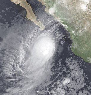
WTropical Depression One-E was the earliest known tropical cyclone to impact the Mexican state of Sinaloa. The first system of the 2009 Pacific hurricane season, One-E formed out of an area of disturbed weather on June 18, 2009, and initially tracked slowly northwards. Throughout the day, convection developed around the center of circulation and the system was anticipated to become a tropical storm. Late on June 18, the National Hurricane Center noted that the system was on the verge of becoming a tropical storm; it would have been named Andres had this occurred. However, the following day, strong wind shear caused the depression to rapidly degenerate into a trough of low pressure before dissipating off the coast of Sinaloa.
 W
WTropical Depression 18W was a weak, short-lived tropical cyclone that brought heavy rains to parts of the Mariana Islands ahead of the more intense Typhoon Melor. Forming from an area of low pressure on September 26, 18W was first monitored by the Japan Meteorological Agency (JMA) as a tropical depression. Tracking generally towards the west, deep convection gradually developed around the system and the Joint Typhoon Warning Center (JTWC) issued their first advisory on the depression early on September 28. Although the depression initially struggled to maintain deep convection, it eventually became better organized and was upgraded to a tropical storm on September 29 by the JTWC. Several hours after reaching this intensity, the system began to rapidly dissipate as its inflow and outflow were severely disrupted by two nearby storms, Parma to the west and Melor to the east. The cyclone fully dissipated near Guam early on September 30 before being absorbed by Typhoon Parma.
 W
WThe 2009 Atlantic hurricane season was a below-average Atlantic hurricane season that produced eleven tropical cyclones, nine named storms, three hurricanes, and two major hurricanes. It officially began on June 1 and ended on November 30, dates that conventionally delimit the period of each year when most tropical cyclones develop in the Atlantic basin. The season's first tropical cyclone, Tropical Depression One, developed on May 28, while the final storm, Hurricane Ida, dissipated on November 10. The most intense hurricane, Bill, was a powerful Cape Verde-type hurricane that affected areas from the Leeward Islands to Newfoundland. The season featured the lowest number of tropical cyclones since the 1997 season, and only one system, Claudette, made landfall in the United States. Forming from the interaction of a tropical wave and an upper-level low, Claudette made landfall on the Florida Panhandle with maximum sustained winds of 45 mph (75 km/h) before quickly dissipating over Alabama. The storm killed two people and caused $228,000 in damage.
WThe 2009 Atlantic hurricane season was an event in the annual tropical cyclone season in the north Atlantic Ocean. It was below-average Atlantic hurricane season with nine named storms, the fewest since the 1997 season. The season officially began on June 1, 2009, and ended on November 30, 2009, dates that conventionally delimit the period of each year when most tropical cyclones develop in the Atlantic basin. The first storm to form was Tropical Depression One on May 28, 2009, while the last storm, Hurricane Ida, dissipated on November 11.
 W
WThe 2008–09 Australian region cyclone season was a near average tropical cyclone season. It officially started on 1 November 2008, and officially ended on 30 April 2009. This season was also the first time that the BoM implemented a "tropical cyclone year." The regional tropical cyclone operational plan defines a "tropical cyclone year" separately from a "tropical cyclone season"; the "tropical cyclone year" began on 1 July 2008 and ended on 30 June 2009.
 W
WThe 2009–10 Australian region cyclone season was a below average tropical cyclone season, with eight tropical cyclones forming compared to an average of 12. The season began on 1 November 2009 and ran through until it end on 30 April 2010. The Australian region is defined as being to south of the equator, between the 90th meridian east and 160th meridian east. Tropical cyclones in this area are monitored by five Tropical Cyclone Warning Centres (TCWC's): Jakarta, Port Moresby, Perth, Darwin, and Brisbane, each of which have the power to name a tropical cyclone. The TCWC's in Perth, Darwin, and Brisbane are run by the Australian Bureau of Meteorology, who designate significant tropical lows with a number and the U suffix. The Joint Typhoon Warning Center also issues unofficial warnings for the region, designating significant tropical cyclones with the "S" suffix when they form west of 135°E, and the "P" suffix when they form east of 135°E.
 W
WThe effects of the 2009 Pacific typhoon season in the Philippines were considered some of the worst in decades. Throughout the year, series of typhoons impacted the country, with the worst damage occurring during September and October from Typhoons Ketsana and Parma.
 W
WThe 2009 Pacific hurricane season was the most active Pacific hurricane season since 1994. The season officially started on May 15 in the East Pacific Ocean, and on June 1 in the Central Pacific; they both ended on November 30. These dates conventionally delimit the period of each year when most tropical cyclones form in the Pacific basin. However, the formation of tropical cyclones is possible at any time of the year.
WBelow is the Timeline of the 2009 Pacific hurricane season, documenting all the storm formations, strengthening, weakening, landfalls, extratropical transitions, as well as dissipation. The 2009 Pacific hurricane season officially began on May 15, 2009, and will last until November 30. For convenience and clarity, in the timeline below, all landfalls are bolded. The timeline will also include information, when it becomes available, which was not operationally released, meaning that information from post-storm reviews by the National Hurricane Center, such as information on a storm that was not operationally warned on, have been included.
 W
WThe 2009 North Indian Ocean cyclone season was an event in the annual cycle of tropical cyclone formation. The North Indian Ocean cyclone season has no official bounds, but cyclones tend to form between April and December, with peaks in May and November. These dates conventionally delimit the period of each year when most tropical cyclones form in the northern Indian Ocean.
 W
WThis is a timeline of the 2009 North Indian Ocean cyclone season, which contains details of when a depression forms, strengthens, weakens, makes landfalls, and dissipates during the 2009 North Indian Ocean cyclone season. It also includes information from post-storm analysis by the Joint Typhoon Warning Center (JTWC), and the India Meteorological Department (IMD) who run the Regional Specialized Meteorological Center in New Delhi, India. RSMC New Delhi's area of responsibility is officially between 45°E and 100E which is east of the Horn of Africa and west of the Malay Peninsula. There are two main seas within the North Indian Ocean, the Arabian Sea and the Bay of Bengal. For storms, these are abbreviated as BOB and ARB by the IMD.
 W
WThe September 2009 Vietnam tropical depression was a weak tropical depression that caused deadly flooding throughout central Vietnam in early September. Forming out of an area of low pressure on September 3, the depression hardly intensified as it meandered off the coast of Vietnam. Initially situated in a favorable environment, convective banding features began to develop and shower and thunderstorm activity formed near the center. On September 4, the Joint Typhoon Warning Center issued a Tropical Cyclone Formation Alert; however, a sudden increase in wind shear caused the system to rapidly become disorganized, leading to the cancellation of the alert the next day. The system continued to slowly track off the coast of Vietnam, nearly dissipating on September 5, before becoming better organized. However, the depression remained weak, with the JTWC reporting on September 7 that the depression had dissipated, though the Japan Meteorological Agency (JMA) continued to issue advisories until the depression dissipated during September 9.
 W
WThe 2008–09 South Pacific cyclone season was a below average tropical cyclone season, which featured six named tropical cyclones compared to an average of about nine. Ahead of the season officially starting on November 1, 2008, the Island Climate Update tropical cyclone outlook predicted that the season, would feature an average risk of tropical cyclones impacting the South Pacific between 160°E and 120°W. The first tropical disturbance of the season developed to the northeast of the Samoan Islands on December 1, however, it remained weak and was last noted during the next day.
 W
WThe 2009–10 South Pacific cyclone season began on December 3, 2009 with the formation of Tropical Disturbance 01F, 32 days after the cyclone season had officially begun on November 1, 2009. The season ended on April 30, 2010. These dates conventionally delimit the period of each year when most tropical cyclones form in the southern Pacific Ocean east of 160°E. Additionally, the regional tropical cyclone operational plan defines a tropical cyclone year separately from a tropical cyclone season; the "tropical cyclone year" began on July 1, 2009 and ended on June 30, 2010. Tropical cyclones between 160°E and 120°W and north of 25°S are monitored by the Fiji Meteorological Service. Those that move south of 25°S are monitored by the Tropical Cyclone Warning Centre in Wellington, New Zealand. The first tropical disturbance of the season formed on December 3, about 1015 km (700 mi) to the north of Suva, Fiji and later intensified into Tropical Cyclone Mick. The last system, 15F, dissipated on April 5 of the following year.
 W
WThe 2008–09 South Pacific cyclone season was a below-average season with only six tropical cyclones occurring within the South Pacific between 160°E and 120°W. The season officially ran from November 1, 2008 to April 30, 2009 with the first disturbance of the season forming on December 1 and the last disturbance moving out of the region on April 11.
WThis timeline documents all of the events of the 2009–10 South Pacific cyclone season which is the period that tropical cyclones formed in the southern Pacific Ocean. Within the Southern Pacific Ocean, most tropical cyclones form within the cyclone season which began on November 1 and will end on April 30, though occasionally cyclones form outside these times. The scope of this article is limited to tropical cyclones that form in the Indian Ocean 160°E and 120°W to the south of the equator. Should a tropical cyclone form to the west of 160°E then it will be monitored within the Australian region by the Australian Bureau of Meteorology, should a tropical cyclone form to the east of 120°W, it is unclear how it will be handled as no tropical cyclone has ever been observed in the South Pacific Ocean east of 120°W.
 W
WThe 2008–09 South-West Indian Ocean cyclone season was a slightly above average event in tropical cyclone formation. It began on November 15, 2008, and officially ended on April 30, 2009, with the exception for Mauritius and the Seychelles, for which it ended on May 15, 2009. These dates conventionally delimit the period of each year when most tropical cyclones form in the basin, which is west of 90°E and south of the Equator. Tropical cyclones in this basin were monitored by the Regional Specialised Meteorological Centre in Réunion.
 W
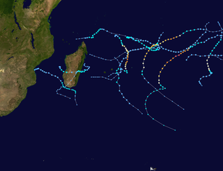
WThe 2009–10 South-West Indian Ocean tropical cyclone season was a near average event in tropical cyclone formation. The season officially started on July 1, 2009, and ended on June 30, 2010, after incorporating the tropical cyclone season which ran from November 1 to April 30 for all areas except for Mauritius and the Seychelles, for which it ended on May 15, 2010. In this basin which officially runs from 30 to 90E, and is, to the south of the equator, the main warning center is the Regional Specialized Meteorological Center on La Reunion Island; however they delegate the naming of Cyclones to the Meteorological services of Mauritius and Madagascar.
WThis timeline documents all of the events of the 2009-10 South-West Indian Ocean cyclone season which is the period that tropical cyclones formed in the Indian Ocean. Within the Indian Ocean most tropical cyclones form within the cyclone season which began on November 1 and will end on April 30. The scope of this article is limited to tropical cyclones that form in the Indian Ocean 30°E and 90°E to the south of the equator. When a zone of disturbed weather form or moves into the South-West Indian Ocean it is assigned a number and monitored by Météo-France who run the Regional Specialized Meteorological Center (RSMC) on Réunion Island. Should a tropical disturbance intensify and become a moderate tropical storm the two sub-regional tropical cyclone Advisory Centres in Mauritius and Madagascar in conjunction with RSMC La Réunion. The United States Joint Typhoon Warning Center (JTWC) also issue warnings on tropical cyclones in this region assigning a number with an "S" suffix. When monitoring a tropical cyclone the Joint Typhoon Warning Center will assess the cyclones intensity on the Saffir–Simpson Hurricane Scale whilst RSMC La Réunion, Mauritius and Madagascar use the Southwest Indian Ocean Tropical Cyclone Intensity Scale to assess a tropical cyclones intensity.
 W
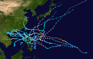
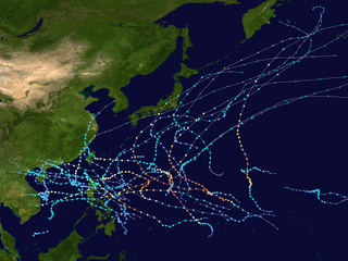
WThe 2009 Pacific typhoon season was a below average season that spawned only 22 named storms, 13 typhoons, and five super typhoons. It was also recognized as the deadliest season in the Philippines for decades. The first half of the season was very quiet whereas the second half of the season was extremely active. The season's first named storm, Kujira, developed on May 3 while the season's last named storm, Nida, dissipated on December 3.
WThis timeline documents all of the events of the 2009 Pacific typhoon season which was the period that tropical cyclones formed in the Western Pacific Ocean during 2009, with most of the tropical cyclones forming between May and November. The scope of this article is limited to the Pacific Ocean, north of the equator between 100°E and the International Date Line. Tropical storms that form in the entire Western Pacific basin are assigned a name by the Japan Meteorological Agency. Tropical depressions that form in this basin are given a number with a "W" suffix by the United States' Joint Typhoon Warning Center. In addition, the Philippine Atmospheric, Geophysical and Astronomical Services Administration (PAGASA) assigns names to tropical cyclones that enter or form in the Philippine area of responsibility. These names, however, are not in common use outside of the Philippines.
 W
WSevere Cyclonic Storm Aila was the second named tropical cyclone of the 2009 North Indian Ocean cyclone season. Warned by both the Regional Specialized Meteorological Center (RMSC) and Joint Typhoon Warning Center (JTWC), Aila formed over a disturbance over the Bay of Bengal on May 23, 2009 and started to intensify and organize reaching sustained wind speeds of 110 kmh (70 mph). It was the worst natural disaster to affect Bangladesh since Cyclone Sidr in November 2007. A relatively strong tropical cyclone, it caused extensive damage in India and Bangladesh.
 W
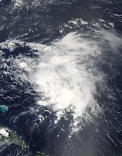
WTropical Storm Ana was the first named storm of the 2009 Atlantic hurricane season and the first tropical cyclone to impact the Caribbean islands during 2009. Forming out of an area of low pressure associated with a tropical wave on August 11, Ana briefly attained tropical storm intensity on August 12 before weakening back to a depression. The following day, the system degenerated into a non-convective remnant low as it tracked westward. On August 14, the depression regenerated roughly 1,075 mi (1,735 km) east of the Leeward Islands. Early on August 15, the storm re-attained tropical storm status, at which time it was named Ana. After reaching a peak intensity with winds of 40 mph (65 km/h) and a barometric pressure of 1003 mbar, the storm began to weaken again due to increasing levels of wind shear and the unusually fast movement of Ana. In post-storm analysis, it was discovered that Ana had degenerated into a tropical wave once more on August 16, before reaching any landmasses.
 W
WHurricane Andres was the first named storm and hurricane of the 2009 Pacific hurricane season. Forming on June 21, Andres gradually intensified as it tracked along the Mexican coastline. Deep convection developed around the center of circulation and by June 23, the storm attained hurricane-status, peaking with winds of 80 mph (130 km/h). Upon attaining this intensity, the storm featured a developing eyewall within a central dense overcast. Within 36 hours, the storm rapidly degenerated, having most of the convection being displaced by high wind shear, becoming a non-tropical trough during the afternoon of June 24.
 W
WTropical Depression Auring formed as a tropical disturbance late on December 30, 2008, to the southeast of Manila in the Philippines. Over the next few days the disturbance gradually developed before early on January 3, the Philippine Atmospheric, Geophysical and Astronomical Services Administration (PAGASA) and the Japan Meteorological Agency (JMA), reported that the disturbance had intensified into the first tropical depression of the season with PAGASA assigning the name Auring to the depression. As the Depression was moving into a high level of vertical wind shear, it did not develop any further and late on January 5 as the baroclinic zone approached Auring, it was downgraded to an area of low pressure by the PAGASA before the JMA followed suit the next day as it was declared as dissipated by the JTWC.
 W
WCyclonic Storm Bijli, was the first tropical cyclone to form during the 2009 North Indian Ocean cyclone season. Bijli formed from an area of Low Pressure on April 14. Later that evening, RSMC New Delhi upgraded the low pressure area to a Depression and designated it as BOB 01. The Joint Typhoon Warning Center (JTWC) then issued a Tropical Cyclone Formation Alert for the system and soon after designated it as Tropical Depression 01B. On the evening of April 15, both RSMC New Delhi and the JTWC reported that the system had intensified into a tropical storm, with the former naming it Bilji. Soon after, Bilji reached its peak intensity as it approached the coast of Bangladesh. However, on the morning of April 17, Bijli weakened to a deep depression due to land interaction, before making landfall just south of Chittagong. The remnants of Bilji continued to weaken as they tracked across northern Myanmar, before RSMC New Delhi issued their last advisory on April 18. The word Bijli refers to lightning in Hindi.
 W
WHurricane Bill was a large Atlantic tropical cyclone that brought minor damage across mainly Atlantic Canada and the East Coast of the United States during August 2009. The second named storm, first hurricane, and first major hurricane of the annual hurricane season, Bill originated from a tropical wave in the eastern Atlantic on August 15. Initially a tropical depression, the cyclone intensified within a favorable atmospheric environment, becoming Tropical Storm Bill six hours after formation. Steered west-northwest around the southern periphery of a subtropical ridge to the northeast of the cyclone, Bill passed through the central Atlantic. At 0600 UTC on August 17, the cyclone strengthened into a Category 1 hurricane on the Saffir–Simpson hurricane wind scale; within 36 hours, Bill entered a period of rapid deepening and intensified into a major hurricane with winds of 115 mph (185 km/h). Passing well northeast of the Lesser Antilles, Bill attained its peak intensity with maximum sustained winds of 130 mph (215 km/h) and a minimum barometric pressure of 943 mb on August 19 and August 20, respectively. Thereafter, an approaching trough induced higher vertical wind shear across the region, causing slow weakening of the hurricane; this same trough resulted in an accelerated motion and curve northward. As the storm passed Bermuda, it contained sustained winds equal to a Category 2, and ultimately struck Newfoundland as a tropical storm. After moving inland and weakening to a tropical storm, Bill began an extratropical transition; this alteration in structure was completed by 1200 UTC on August 24. Two days later, Bill's remnant low was absorbed into a larger extratropical system over the Northern Atlantic.
 W
WTyphoon Chan-hom, known in the Philippines as Typhoon Emong, was the sixth tropical depression and the second tropical storm to develop during the 2009 Pacific typhoon season. Chan-hom developed out of an area of convectional cloudiness associated with an area of disturbed weather which originated from the remnants of Tropical Depression Crising and formed southeast of Nha Trang, Vietnam on May 2. Moving towards the northeast, it slowly organized according to JTWC who issued a TCFA, and JMA classified Chan-hom as a minor tropical depression later that day. The next day, both JTWC and JMA upgraded the depression to a tropical storm and named it Chan-hom. On May 6, the storm intensified into a Category 1 typhoon, and on May 7, Chan-hom intensified into a Category 2 typhoon equivalent. However, Chan-hom weakened into a severe tropical storm after passing northern Luzon. On May 14, Chan-hom regenerated into a Tropical Depression, before dissipating late on May 15.
 W
WTyphoon Choi-wan was a powerful typhoon that became the first Category 5 equivalent-super typhoon to form during the 2009 Pacific typhoon season. Forming on September 11, 2009, about 1100 km (700 mi) to the east of Guam, the initial disturbance rapidly organized into a tropical depression. By September 12, the depression intensified into a tropical storm, at which time it was given the name Choi-wan. The following day, rapid intensification took place through September 14. Choi-wan attained its peak intensity on September 15, as it moved through the Northern Mariana Islands with the Japan Meteorological Agency reporting peak windspeeds of 195 km/h. Additionally, the Joint Typhoon Warning Center reported the storm to have attained winds of 260 km/h. The typhoon remained very powerful until September 17 when the storm's outflow weakened. The typhoon underwent an eyewall replacement cycle, leading to intensity fluctuations. By September 19, Choi-wan rapidly weakened as strong wind shear caused convection to diminish. The following day, the system transitioned into an extratropical cyclone and dissipated several hours later over open waters.
 W
WTropical Storm Claudette was the third named storm of the 2009 Atlantic hurricane season and the first tropical cyclone of 2009 to affect the United States. Forming out of a tropical wave and an upper-level low pressure system on August 16, Claudette quickly intensified into a tropical storm offshore south of Tallahassee, Florida. By the afternoon, the storm had attained winds of 60 mph (95 km/h) and steadily tracked towards the Florida Panhandle. Early on August 17, the center of Claudette made landfall on Santa Rosa Island. Several hours after landfall, the storm weakened to a tropical depression and the Hydrometeorological Prediction Center took over primary responsibility of the storm. Later on August 17, the final public advisory was issued on the system as it dissipated over Alabama.
 W
WTropical Storm Danny was a weak and disorganized tropical cyclone that formed in August 2009. The fourth tropical system and third named storm of the 2009 Atlantic hurricane season, Danny developed on August 26 from the interaction between a westward-moving tropical wave and an upper-level trough while situated east of the Bahamas. The storm never fully matured, and resembled a subtropical cyclone. It meandered generally northwestward before being absorbed into another weather system on August 29.
 W
WTropical Storm Erika was a short-lived tropical cyclone that brought minor impacts to the Lesser Antilles. The fifth named storm of the 2009 Atlantic hurricane season, Erika originated out of a tropical wave on September 1 near the Lesser Antilles. Although it was a disorganized system, it was immediately declared a tropical storm, rather than a tropical depression. Later that day, the system reached its peak intensity with winds of 50 mph (85 km/h) and a barometric pressure of 1004 mbar. Increased wind shear caused the storm to weaken shortly thereafter, with Erika barely maintaining tropical storm-status by September 2. Later that day, the storm passed over the island of Guadeloupe and entered the Caribbean Sea. On September 3, Erika weakened to a tropical depression as the low pressure center became fully displaced from convective activity. Later that day, the system degenerated into a remnant low before dissipating near Puerto Rico on September 4.
 W
WTropical Storm Etau was the deadliest tropical cyclone to impact Japan since Typhoon Tokage in 2004. Forming on August 8, 2009 from an area of low pressure, the system gradually intensified into a tropical storm. Tracking in a curved path around the edge of a subtropical ridge, Etau continued to intensify as it neared Japan. By August 10, the cyclone reached its peak intensity as a weak tropical storm with winds of 75 km/h and a barometric pressure of 992 hPa (mbar). Shortly after, Etau began to weaken. Increasing wind shear led to the center becoming devoid of convection and the system eventually weakened to a tropical depression on August 13. The remnants of Etau persisted for nearly three days before dissipating early on August 16.
 W
WIntense Tropical Cyclone Fanele was the first cyclone of tropical cyclone status to strike western Madagascar since Cyclone Fame one year prior. It formed on January 18, 2009 in the Mozambique Channel, and rapidly organized as it remained nearly stationary. Fanele ultimately turned toward the southwest Madagascar coastline, reaching peak winds of 185 km/h (115 mph), according to the Réunion Météo-France office (MFR). It weakened before moving ashore in Menabe Region southwest of Morondava, and rapidly weakened over land. Fanele briefly re-intensified after reaching open waters, only to become an extratropical cyclone by January 23.
 W
WHurricane Felicia was the third strongest tropical cyclone of the 2009 Pacific hurricane season, as well as the strongest storm to exist in the eastern Pacific at the time since Hurricane Daniel in 2006. Forming as a tropical depression on August 3, the storm supported strong thunderstorm activity and quickly organized. It became a tropical storm over the following day, and subsequently underwent rapid deepening to attain hurricane status. Later that afternoon, Felicia featured a well-defined eye as its winds sharply rose to major hurricane-force on the Saffir–Simpson scale. Further strengthening ensued, and Felicia peaked in intensity as a Category 4 hurricane with sustained winds of 145 mph (230 km/h) and a barometric pressure of 935 mbar. After reaching this strength, unfavorable conditions, such as wind shear, began to impact the storm while it took on a northwestward path. Henceforth, Felicia slowly weakened for several days; by August 8 it had been downgraded to a Category 1 hurricane, once again becoming a tropical storm the next day. It retraced westward towards Hawaii on August 10, all the while decreasing in organization. On August 11, Felicia weakened to tropical depression status, and soon degenerated into remnant low just prior to passing over the islands.
 W
WHurricane Fred was one of the easternmost forming major hurricanes in the North Atlantic basin since satellite observations became available. Forming out of a strong tropical wave on September 7, 2009 near the Cape Verde Islands, Fred gradually organized within an area of moderate wind shear. The following day, decreasing shear allowed the storm to intensify and develop well-organized convective banding features. Later on September 8, Fred attained hurricane intensity and underwent rapid intensification overnight, attaining its peak intensity as a strong Category 3 hurricane with winds of 120 mph (195 km/h) and a barometric pressure of 958 mbar. Shortly after reaching this intensity, the hurricane began to weaken as wind shear increased and dry air hampered convective development.
 W
WTropical Storm Grace holds the record for being the farthest northeast forming tropical cyclone in the Atlantic basin. The seventh named storm of the slightly below average 2009 Atlantic hurricane season, Grace formed from an extratropical cyclone over the Azores on October 4. It strengthened to attain peak sustained winds of 65 mph (100 km/h) and developed an eye-like feature, although cold sea surface temperatures inhibited the development of thunderstorm activity near the center. The storm lost its tropical characteristics on October 6, and the storm's remnants merged with a separate system near the British Isles on October 7.
 W
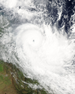
WSevere Tropical Cyclone Hamish was a powerful tropical cyclone that caused extensive damage to the Great Barrier Reef and coastal Queensland, Australia, in March 2009. The eighth named storm of the 2008–09 Australian region cyclone season, Hamish developed out of an area of low pressure on 4 March near the Cape York Peninsula. The storm rapidly developed into a Category 1 cyclone on the Australian intensity scale the next day. On 6 March, an eye developed, and Hamish strengthened into a Category 3 cyclone. Deep convection developed around the eye, fueling further intensification, which allowed the storm to become a Category 5 tropical cyclone late on 7 March. Hamish made its closest approach to land on 8 March, but continued moving southeastward. Eventually, the cyclone weakened and turned back towards the northwest, weakening into a remnant low on 11 March, before finally dissipating on 14 March.
 W
WSevere Tropical Storm Hubert was a destructive tropical cyclone that killed 85 people throughout Madagascar early March 2010. Forming out of a slow-moving area of low pressure on March 9, Hubert quickly developed within a region favoring tropical development. Situated off the coast of Madagascar, the storm attained peak winds of 100 km/h (65 mph) just hours before making landfall on March 10 near Mananjary in Fianarantsoa Province. Rapid weakening took place once over land, with the storm losing gale-force winds late on March 11. The remnants of Hubert persisted for several more days, eventually dissipating off the southern coast of Madagascar on March 15.
 W
WHurricane Ida was the strongest landfalling tropical cyclone during the 2009 Atlantic hurricane season, crossing the coastline of Nicaragua with winds of 80 mph (130 km/h). The remnants of the storm became a powerful nor'easter that caused widespread damage along coastal areas of the Mid-Atlantic States. Ida formed on November 4 in the southwestern Caribbean, and within 24 hours struck the Nicaragua coast with winds of 80 mph (130 km/h). It weakened significantly over land, although it restrengthened in the Yucatán Channel to peak winds of 105 mph (165 km/h). Hurricane Ida weakened and became an extratropical cyclone in the northern Gulf of Mexico before spreading across the southeastern United States. The remnants of Ida contributed to the formation of a nor'easter that significantly affected the eastern coast of the United States.
 W
WHurricane Jimena was the second-strongest hurricane of the 2009 Pacific hurricane season, and tied with Hurricane Norbert as the strongest tropical cyclone to make landfall on western portion of the Baja California Peninsula. Forming from a tropical wave late on August 28, 2009, off of Mexico's Pacific coast, the system rapidly intensified into a Category 2 hurricane on the next day. Two days after developing, Jimena strengthened into a Category 4 hurricane. After peaking close to Category 5 intensity on September 1, it encountered cold water and began to weaken. When the hurricane made landfall on the Baja California Peninsula on September 3, it was only a Category 2 hurricane. On the next day, the tropical cyclone entered the Gulf of California, though the storm weakened into a remnant low after looping back eastward towards Baja California. The storm's remnants drifted westward into the Pacific afterward, before dissipating on September 8.
 W
WTyphoon Ketsana, known in the Philippines as Tropical Storm Ondoy, was the second-most devastating tropical cyclone of the 2009 Pacific typhoon season, causing $1.15 billion in damages and 921 fatalities, only behind Morakot earlier in the season, which caused 789 deaths and damages worth $6.2 billion. Ketsana was the sixteenth tropical storm, and the eighth typhoon of the season. It was the most devastating tropical cyclone to hit Manila, surpassing Typhoon Patsy (Yoling) in 1970.
 W
WTyphoon Kujira, known in the Philippines as Typhoon Dante, was first reported by the Joint Typhoon Warning Center (JTWC) on April 28. It was the fourth depression and the first typhoon of the season. The disturbance dissipated later that day however it regenerated early on April 30 within the southern islands of Luzon. It was then designated as a Tropical Depression during the next morning by the Philippine Atmospheric, Geophysical and Astronomical Services Administration (PAGASA) and the Japan Meteorological Agency (JMA), with PAGASA assigning the name Dante to the depression. However the JTWC did not designate the system as a depression until early on May 2 which was after the depression had made landfall on the Philippines. Later that day Dante was upgraded to a Tropical Storm and was named as Kujira by the JMA. The cyclone started to rapidly intensify becoming a typhoon early on May 4, and then reaching its peak winds of 155 km/h (100 mph) (10-min), 215 km/h (135 mph) (1-min) later that day after a small clear eye had developed.
 W
WSevere Tropical Cyclone Laurence of December 2009 was the first Category 5 tropical cyclone to make landfall in Australia, since Cyclone George in 2007.
 W
WSevere Tropical Storm Linfa was the second named storm to develop in the South China Sea during the 2009 Pacific typhoon season. It is the seventh depression and third typhoon of the season. Forming out of an area of low pressure on June 14, the storm briefly attained tropical depression status before degenerating. By June 17 the system regenerated in the South China Sea. Slowly tracking northward, the storm intensified, attaining severe tropical storm status on June 19 and peaking in intensity the following day. On June 21, Linfa made landfall in Fujian Province, China as a tropical storm before weakening to a tropical depression.
 W
WTyphoon Melor, known in the Philippines as Typhoon Quedan, was the second category 5 typhoon in 2009. It interacted with Typhoon Parma in the first week of October southeast of Taiwan.
 W
WTyphoon Mirinae, known in the Philippines as Typhoon Santi, was the 34th depression and the 14th typhoon in the 2009 Pacific typhoon season. It came several weeks after Typhoons Ketsana and Parma devastated the Philippines, thus adding additional damage wrought by the two typhoons.
 W
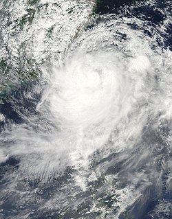
WTyphoon Morakot, known in the Philippines as Typhoon Kiko, was the deadliest typhoon to impact Taiwan in recorded history. The eighth named storm and fourth typhoon of the 2009 Pacific typhoon season, Morakot wrought catastrophic damage in Taiwan, leaving 673 people dead and 26 missing, and causing roughly NT$110 billion (US$3.3 billion) in damages. The storm produced copious amounts of rainfall, peaking at 2,777 mm (109.3 in), far surpassing the previous record of 1,736 mm (68.35 in) set by Typhoon Herb in 1996. The extreme amount of rain triggered enormous mudflows and severe flooding throughout southern Taiwan. One landslide destroyed the entire town of Siaolin, killing over 400 people. The slow-moving storm also caused widespread damage in China, leaving eight people dead and causing $1.4 billion in damages. Nearly 2,000 homes were destroyed in the country and 136,000 more were reported to have sustained damage.
 W
WTropical Storm Mujigae, known in the Philippines as Tropical Depression Maring, formed as a tropical disturbance during September 8, to the northwest of Manila in the Philippines it rapidly consolidated and was designated as Tropical Depression Maring later that day.
 W
WHurricane Neki was the final tropical cyclone of the 2009 Pacific hurricane season. It developed on October 18 as an unusually large disturbance from a trough south of Hawaii. Moving northwestward, it slowly organized at first due to its large size. After reaching hurricane status on October 21, Neki intensified at a much faster rate and peaked with winds of 125 mph (205 km/h). It later turned to the north and north-northeast and weakened due to hostile conditions. While passing through the Papahānaumokuākea Marine National Monument, Neki was downgraded to a tropical storm after the center became exposed from the deepest convection. It caused little impact in the island chain. After stalling and executing a small loop, Neki resumed its northward track and dissipated on October 27.
 W
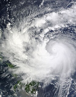
WTyphoon Nida, known in the Philippines as Tropical Storm Vinta, was the most intense tropical cyclone in the Northwest Pacific Ocean during the 2000s, tied with Jangmi in 2008. It was also the most intense tropical cyclone worldwide in 2009.
 W
WTyphoon Parma, known in the Philippines as Typhoon Pepeng, was the second typhoon to affect the Philippines within the span of a week during September 2009.
 W
WTropical Storm Patricia was a short-lived tropical cyclone that briefly affected parts of Baja California Sur before rapidly degenerating over water. Developing from a tropical wave that traversed the Atlantic Ocean during September 2009, Patricia was first classified as a tropical depression on October 11 several hundred miles south of the Baja California Peninsula. The system quickly intensified into a tropical storm as it tracked in a general northward direction. By October 12, Patricia attained its peak intensity with winds of 60 mph (95 km/h) and a minimum barometric pressure of 996 mbar. The following day, increasing wind shear and unfavorable conditions caused the storm to rapidly weaken. By the morning of October 14, Patricia had degenerated into a non-convective remnant low pressure area near the southern coastline of Baja California Sur. The remnants of the storm persisted until October 15, at which time they dissipated over open waters.
 W
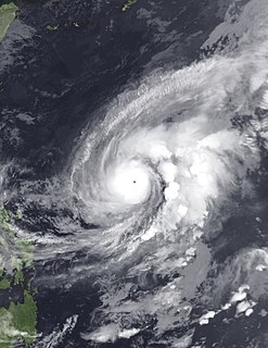
WHurricane Rick is the third-most intense Pacific hurricane on record and the second-most intense tropical cyclone worldwide in 2009, only behind Typhoon Nida. Developing off the southern coast of Mexico on October 15, Rick traversed an area favoring rapid intensification, allowing it to become a hurricane within 24 hours of being declared a tropical depression. An eye began to form during the afternoon of October 16; once fully formed, the storm underwent another period of rapid strengthening. During the afternoon of October 17, the storm attained Category 5 status on the Saffir–Simpson hurricane wind scale. Several hours later, Rick attained its peak intensity as the third-strongest Pacific hurricane on record with winds of 180 mph (285 km/h) and a barometric pressure of 906 mbar.
 W
WTropical Storm Soudelor, known in the Philippines as Tropical Depression Gorio, was a weak tropical cyclone that produced deadly flooding in the Philippines, China and Vietnam in July 2009. Forming out of an area of low pressure on July 9, Soudelor failed to maintain deep convection around its center for the duration of its existence. On July 10, the depression brushed the northern Philippines and intensified into a tropical storm on July 11. Later that day, the storm crossed the Leizhou Peninsula. The last public advisory from the JMA was issued the following day after Soudelor made landfall in southern China.