 W
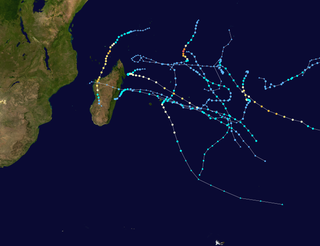
WDuring 2020, tropical cyclones formed within seven different tropical cyclone basins, located within various parts of the Atlantic, Pacific and Indian Oceans. During the year, 140 tropical cyclones formed in bodies of water known as tropical cyclone basins. Of these, 104, including three subtropical cyclones in the South Atlantic Ocean and three tropical-like cyclones in the Mediterranean Sea, were named by various weather agencies when they attained maximum sustained winds of 35 knots. The strongest storm of the year was Yasa, peaking with a pressure of 899 hPa (26.55 inHg) and with 10-minute sustained winds of 250 km/h (155 mph). The deadliest storm of the year was Eta which caused 211 fatalities and another 120 to be missing in Central America and the U.S, while the costliest storm of the year was Laura, with a damage cost around $16.1 billion in the Greater Antilles, The Bahamas, and the Gulf Coast of the United States.
 W
WThe 2020 Atlantic hurricane season was the most active and the seventh costliest Atlantic hurricane season on record. In addition, it was the fifth consecutive above average Atlantic hurricane season from 2016 onward. The season featured a total of 31 (sub)tropical cyclones, all but one of which became a named storm. Of the 30 named storms, 13 developed into hurricanes, and six further intensified into major hurricanes, with one, Hurricane Iota, attaining Category 5 strength on the Saffir–Simpson scale. It was the second season to use the Greek letter storm naming system, the first being 2005. Of the 30 named storms, 12 of them made landfall in the contiguous United States, breaking the record of nine set in 1916. The season was also the fifth consecutive season in which at least one Category 5 hurricane formed. During the season, 27 tropical storms established a new record for the earliest formation by storm number. This season also featured a record 10 tropical cyclones that underwent rapid intensification, tying it with 1995. This unprecedented activity was fueled by a La Niña that developed in the summer months of 2020.
 W
WThe 2019–20 Australian region cyclone season was a below average tropical cyclone season for the waters surrounding Australia between longitudes 90°E and 160°E. The season officially began on 1 November 2019 and ended on 30 April 2020; however, tropical cyclones can form at any time of year, as evidenced by Tropical Cyclone Mangga during May 2020. As such, any system existing between 1 July 2019 and 30 June 2020 would count towards the season total. The season featured the region's second-latest start on record, with the formation of the first tropical low only occurring on 4 January 2020. A total of eight tropical cyclones formed during the season, which represents the region's least active season since the 2016–17 season. Three systems intensified further into severe tropical cyclones, and three systems made landfall within the region at tropical cyclone intensity. A total of 28 fatalities were caused, either directly or indirectly, as a result of impacts from the season's systems. Severe Tropical Cyclone Damien, the strongest of the year, became the strongest tropical cyclone to strike Western Australia's Pilbara Region since Cyclone Christine in 2013.
 W
WThe 2020–21 Australian region cyclone season is the period of the year when tropical cyclones form in the Southern Indian Ocean and Pacific Oceans between 90°E and 160°E. The season officially began on 1 November 2020 and will end on 30 April 2021, however, a tropical cyclone could form at any time between 1 July 2020 and 30 June 2021 and would count towards the season total. During the season, tropical cyclones will be officially monitored by one of the three tropical cyclone warning centres (TCWCs) for the region which are operated by the Australian Bureau of Meteorology, National Weather Service of Papua New Guinea and the Indonesian Agency for Meteorology, Climatology and Geophysics. The United States Joint Typhoon Warning Center (JTWC) and other national meteorological services including Météo-France will also monitor the basin during the season.
 W
WThe 2020 North Indian Ocean cyclone season was the costliest North Indian Ocean cyclone season in recorded history, largely due to Super Cyclonic Storm Amphan. The North Indian Ocean cyclone season has no official bounds, but cyclones tend to form between April and November, with peaks in late April to May and October to November. These dates conventionally delimit the period of each year when most tropical cyclones form in the northern Indian Ocean. The season began on May 16 with the designation of Depression BOB 01 in the Bay of Bengal, which later became Cyclone Amphan, the strongest storm in the Bay of Bengal recorded since the 1999 Odisha cyclone and breaking the record of Cyclone Nargis of 2008 as the costliest storm ever recorded in the basin.
 W
WThe 2020 Pacific hurricane season was the least active Pacific hurricane season since 2010. The season was near-average in terms of tropical storms, featuring a total of 17, but had a well below average number of hurricanes and major hurricanes with merely 4 hurricanes and 3 major hurricanes forming. The season was also the first since 1996 to feature an unnamed storm, Tropical Storm Seven-E, which was operationally classified as a tropical depression. Despite this, it featured the earliest start to a season east of 140°W on record, with Tropical Depression One-E forming on April 25, surpassing the previous early record of Tropical Storm Adrian in 2017 by two weeks. The season officially began on May 15 in the East Pacific Ocean, and on June 1 in the Central Pacific and they both ended on November 30. These dates conventionally delimit the period of each year when most tropical cyclones form in the Pacific basin. However, the formation of tropical cyclones is possible at any time of the year, as shown by the record-early formation of Tropical Depression One-E.
 W
WThe 2020 Pacific typhoon season was a slightly-below average season in the annual cycle of tropical cyclone formation in which 23 tropical storms and 10 typhoons formed in the western Pacific Ocean. It is also the fifth-latest start in the basin on record, slightly behind 1973, and the first to start this late since 2016. The first half of the season was unusually inactive, with only four systems, two named storms and one typhoon at the end of July. Additionally, the JTWC recorded no tropical cyclone development in the month of July, the first such occurrence since reliable records began. The season's first named tropical cyclone, Vongfong, developed on May 8, while the season's last named tropical cyclone, Krovanh, dissipated on December 24. However, the season's last system was an unnamed tropical depression which dissipated on December 29. The 2020 Pacific typhoon season was less active than the 2020 Atlantic hurricane season, which has only happened twice before: in 2005 and 2010.
 W
WThe 2019–20 South Pacific cyclone season was a slightly above-average season in which tropical cyclones formed within the South Pacific Ocean to the east of 160°E. The season officially ran from November 1, 2019 to April 30, 2020, however a tropical cyclone could form at any time between July 1, 2019 and June 30, 2020 and would count towards the season total. The season began on November 22 with the formation of Tropical Cyclone Rita, which would later become a severe tropical cyclone. The season has been near-average in terms of activity, with 8 tropical cyclones and 4 severe tropical cyclones forming during the season. The season featured Cyclone Harold, the first Category 5 severe tropical cyclone in the basin since Cyclone Gita, and one of the strongest since Cyclone Winston. During the season, tropical cyclones are officially monitored by the Fiji Meteorological Service (FMS), Australian Bureau of Meteorology (BOM) and New Zealand's MetService. The United States Armed Forces through the Joint Typhoon Warning Center (JTWC) also monitors the basin and issue unofficial warnings for American interests. The FMS attaches a number and an F suffix to tropical disturbances that form in or move into the basin while the JTWC designates significant tropical cyclones with a number and a P suffix. The FMS, BoM and MetService all use the Australian Tropical Cyclone Intensity Scale and estimate wind speeds over a period of ten minutes, while the JTWC estimated sustained winds over a 1-minute period, which are subsequently compared to the Saffir–Simpson hurricane wind scale (SSHWS)
 W
WThe 2019–20 South-West Indian Ocean cyclone season was a slightly above-average season in tropical cyclone and subtropical cyclone formation west of 90°E. The season officially began on 15 November, however, the formation of the first system—Zone of Disturbed Weather 01—occurred on 22 July 2019, well before the official start of the season. This was the earliest start to a season since the 2016-17 season. The season then officially ended on 30 April 2020, with the exception of Mauritius and the Seychelles, for which it officially ended on 15 May 2020. These dates conventionally delimit the period of each year when most tropical and subtropical cyclones form in the basin, which is west of 90°E and south of the Equator. Tropical and subtropical cyclones in this basin are monitored by the Regional Specialized Meteorological Centre in Réunion.
 W
WThe 2020–21 South-West Indian Ocean cyclone season is an ongoing event of the annual cycle of tropical cyclone and subtropical cyclone formation. The season started with the formation of Tropical Cyclone Alicia in the extreme northeast section of the basin on 12 November, just before the official start of the season, which marked the third season in a row in which a tropical cyclone formed before the beginning of the season. It officially began on 15 November 2020, and will officially end on 30 April 2021, with the exception for Mauritius and the Seychelles, for which it will officially end on 15 May 2021. These dates conventionally delimit the period of each year when most tropical and subtropical cyclones form in the basin, which is west of 90°E and south of the Equator. Tropical and subtropical cyclones in this basin are monitored by the Regional Specialised Meteorological Centre in Réunion.
 W
WTropical Storm Amanda was a short-lived but devastating tropical cyclone that is regarded as the worst natural disaster in El Salvador since Hurricane Mitch. Amanda caused deadly flooding and landslides across Central America and Mexico in late-May 2020 that killed 40 people. The second tropical cyclone and first named storm of the 2020 Pacific hurricane season, Amanda developed out of a broad area of low pressure associated with a tropical wave, that moved off the coast of Nicaragua on May 26. The disturbance slowly developed a more well defined circulation and on May 30, and the system was designated as Tropical Depression Two-E. Originally expected not to significantly strengthen, nevertheless it compacted and was upgraded to Tropical Storm Amanda at 09:00 UTC the next day. Three hours later, Amanda made landfall in southeast Guatemala, the first tropical cyclone to make landfall along that nation's Pacific coast since Tropical Storm Agatha in 2010. Once inland, Amanda rapidly weakened and dissipated over the region's rough terrain. However, the system's remnants survived, crossing Central America and Mexico and re-organized into Tropical Storm Cristobal in the Atlantic.
 W
WSuper Cyclonic Storm Amphan was a powerful and catastrophic tropical cyclone that caused widespread damage in Eastern India, specifically West Bengal, and in Bangladesh in May 2020. It was the strongest tropical cyclone to strike the Ganges Delta since Sidr of the 2007 season and the first super cyclonic storm to have formed in the Bay of Bengal since the 1999 Odisha cyclone. It was also the fourth super cyclone that hit West Bengal since 1582, after 1737, 1833 and 1942, as well as being one of the strongest storm to impact the area. Causing over US$13 billion of damage, Amphan is also the costliest cyclone ever recorded in the North Indian Ocean, surpassing the record held by Cyclone Nargis of 2008.
 W
WTropical Storm Arthur was a strong off-season tropical storm that impacted the East Coast of the United States in May 2020. The first of thirty-one depressions and thirty different named storms of the extremely active 2020 Atlantic hurricane season, Arthur marked the record sixth consecutive year in the Atlantic basin with a tropical cyclone forming before June. It was one of two off-season storms in the season, alongside short-lived Tropical Storm Bertha. Arthur originated from a broad trough that formed on May 14 near Cuba, which slowly drifted south of Florida through the Florida Strait for two days. The system became a tropical depression on May 16 north of The Bahamas. A day later, the system intensified into a tropical storm and was named Arthur. Arthur gradually intensified while tracking towards the Outer Banks of North Carolina, before skirting the region and becoming extratropical. The cyclone then accelerated towards Bermuda and dissipated on May 21.
 W
WTropical Storm Bertha was a rapidly forming and short-lived off-season tropical storm that affected the Eastern United States in late May 2020. The second named storm of the very active 2020 Atlantic hurricane season, Bertha originated from a trough in the Gulf of Mexico. The National Hurricane Center (NHC) only anticipated slight development as the trough moved over southern Florida, bringing torrential rainfall. The system rapidly organized on May 27 after it emerged into the western Atlantic Ocean, developing a small, well-defined circulation. That day, the disturbance consolidated into Tropical Storm Bertha east of Georgia, and a few hours later it moved ashore near Isle of Palms, South Carolina with peak winds of 50 mph (85 km/h). The storm weakened over land and dissipated late on May 28 over West Virginia.
 W
WTropical Storm Cristobal was the earliest third named storm in the North Atlantic Ocean on record, breaking the record set by Tropical Storm Colin in 2016 which formed on June 5. It is also the first Atlantic tropical cyclone to form in the month of June since Cindy in 2017, and the first June tropical cyclone to make landfall in Mexico since Danielle in 2016. The third named storm of the extremely-active 2020 Atlantic hurricane season, Cristobal formed on June 1 over the Bay of Campeche from the remnants of Tropical Storm Amanda in the Eastern Pacific. Cristobal then made landfall in the state of Campeche at 13:35 UTC on June 3, 2020, with sustained winds of 60 mph (95 km/h), causing torrential rainfall throughout the region. It slowly curved northward over Mexico and progressed into the Gulf of Mexico. Cristobal then made a second landfall over southeastern Louisiana at 22:10 UTC on June 7, becoming the second-earliest tropical cyclone to make landfall in Louisiana. The system progressed north through the Mississippi Valley, managing to survive over land as a tropical depression until finally becoming extratropical over southern Wisconsin at 03:00 UTC on June 10. This extratropical low then moved north past Lake Superior and to near James Bay, before heading northeastward toward the Labrador Sea.
 W
WCyclonic Storm Burevi was a weak tropical cyclone which made landfall in Sri Lanka, becoming the first to do so since a depression in 2014, and brought minimal impact to Southern India in December 2020. The ninth depression and fifth named storm of the 2020 North Indian Ocean cyclone Season, Burevi originated from a low pressure area which formed on November 28. The system gradually became a depression on November 30, with the JTWC issuing a TCFA soon after. The depression then was upgraded into Cyclone Burevi the following day. Burevi slowly intensified reaching its peak intensity on December 2, just before making landfall in Sri Lanka. Burevi then weakened, entering the Gulf of Mannar the next day. Burevi proceeded to dissipate after stalling on December 5.
 W
WCyclone Ianos, also known as Medicane Ianos, was a rare Mediterranean tropical-like cyclone (medicane), that impacted Greece on 17 and 18 September 2020. Ianos developed from an area of low pressure over the Gulf of Sidra that quickly began tropical cyclogenesis while moving over warm waters. After receiving various names from different meteorological centers, the storm, dubbed Ianos by the Greeks, rapidly intensified while moving northeast. After scraping Italy, the storm went on to hit Malta and Crete with tropical storm-force winds. Despite land interaction, the small cyclone reached its peak intensity of 120 km/h (75 mph) on 18 September, immediately before making landfall in southwestern Greece. After landfall, Ianos turned back out to sea and moved south-southeastward, before dissipating on 21 September.
 W
WVery Severe Cyclonic Storm Nivar was a tropical cyclone which brought severe impacts to portions of Tamil Nadu and Andhra Pradesh in late November of 2020. The eighth depression and fourth named storm of the 2020 North Indian Ocean cyclone season, Nivar originated from a disturbance in the Intertropical Convergence Zone. The disturbance gradually organized and on November 23, both the Joint Typhoon Warning Center (JTWC) and the India Meteorological Department (IMD) reported that a tropical depression has formed. On the next day, both agencies upgraded the system to a tropical storm, with the latter assigning it the name Nivar. Nivar made its landfall over North Coastal Tamilnadu between Puducherry and Chennai close to Marakkanam. Overall, Nivar caused $600 million dollars in damages.
 W
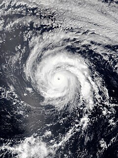
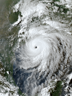
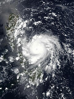
WSevere Tropical Cyclone Yasa was the strongest tropical cyclone in the South Pacific since Winston in 2016, as well as the fourth most intense tropical cyclone on record in the basin. It was also the second Category 5 severe tropical cyclone in 2020 after Harold in the 2019–20 South Pacific cyclone season. Yasa was the second tropical disturbance, as well as the first tropical cyclone and severe tropical cyclone of the 2020–21 South Pacific cyclone season. Yasa was first noted as an area of low pressure to the north of Port Vila in Vanuatu during December 10. Over the next few days, the system gradually developed further as it absorbed Tropical Depression 01F, before it was classified as a tropical cyclone and named Yasa by the Fiji Meteorological Service on December 13.
 W
WHurricane Delta was the record-tying fourth named storm of 2020 to strike Louisiana, as well as the record-breaking tenth named storm to strike the United States in that year. The twenty-sixth tropical cyclone, twenty-fifth named storm, ninth hurricane, and third major hurricane of the record-breaking 2020 Atlantic hurricane season, Delta formed from a tropical wave which was first monitored by the National Hurricane Center (NHC) on October 1. Moving westward, the tropical wave began to quickly organize and due to its imminent threat to land, it was designated a potential tropical cyclone late on October 4. The next day, the system sufficiently organized and was designated as Tropical Depression Twenty-six and soon thereafter, Tropical Storm Delta. Extremely rapid intensification ensued throughout October 5 into October 6, with Delta becoming a Category 4 hurricane within 28 hours of attaining tropical storm status. The rate of intensification was the fastest in the Atlantic basin since Hurricane Wilma in 2005. After peaking in intensity however, an unexpected slight increase in wind shear greatly disrupted the small core of Delta and the storm quickly weakened before making landfall in Puerto Morelos, Mexico, as a high-end Category 2 hurricane with 110 miles per hour. It weakened some more over land before emerging into the Gulf of Mexico, where it was downgraded to a Category 1 hurricane. After that, it began to restrengthen, regaining Category 3 status late on October 8. It then turned northward and reached a secondary peak intensity of 953 mb and winds of 120 mph early on October 9. Delta then began to turn more north-northeastward into an area of cooler waters, higher wind shear, and dry air, causing it to weaken back to Category 2 status. Delta then made landfall at 23:00 UTC near Creole, Louisiana with winds of 100 mph (155 km/h) and a pressure of 970 mb (28.64 inHg). The storm began to weaken more rapidly after landfall, becoming post-tropical just 22 hours later.
 W
WHurricane Douglas was a strong tropical cyclone that became the closest passing Pacific hurricane to the island of Oahu on record, surpassing the previous record held by Hurricane Dot in 1959. The eighth tropical cyclone, fourth named storm, first hurricane, and first major hurricane of the slightly below-average 2020 Pacific hurricane season, Douglas originated from a tropical wave which entered the basin in mid-July. Located in favorable conditions, the wave began to organize on July 19. It became a tropical depression on July 20 and a tropical storm the following day. After leveling off as a strong tropical storm due to dry air, Douglas began rapid intensification on July 23, becoming the season's first major hurricane the following day and peaking as a Category 4 hurricane. After moving into the Central Pacific basin, Douglas slowly weakened as it approached Hawaii. The storm later passed north of the main islands as a Category 1 hurricane, passing dangerously close to Oahu and Kauai, causing minimal damage, and resulting in no deaths or injuries. Douglas weakened to tropical storm status on July 28 as it moved away from Hawaii, before dissipating a day later.
 W
WTropical Storm Fay was the first tropical cyclone to make landfall in the U.S state of New Jersey since Irene in 2011. The sixth named storm of the very active 2020 Atlantic hurricane season, Fay was the earliest sixth named storm on record in the basin when it formed on July 9. Fay originated from a surface low that formed over the Northern Gulf of Mexico on July 3 and slowly drifted east before crossing over the Florida Panhandle and drifting across the Southeastern United States as a well-defined surface low, emerging off the coast of North Carolina on July 8. From there, the storm utilized favorable conditions for cyclogenesis and coalesced into a tropical storm on July 9. The storm intensified before shifting west and landfalling in New Jersey later on July 10. After making landfall, the storm lost deep convection and degenerated into a post-tropical cyclone on July 11.
 W
WVery Severe Cyclonic Storm Gati was the strongest tropical cyclone on record to make landfall in Somalia, and one of few tropical cyclones to do so in the country. The seventh depression, third cyclonic storm, and second very severe cyclonic storm of the 2020 North Indian Ocean cyclone season, Gati formed from an area of low pressure in the Arabian Sea, on 21 November. The storm then explosively intensified, becoming a very severe tropical cyclone and reaching its peak intensity, the following day. Gati weakened slightly before making landfall in northeastern Somalia on 22 November. Gati was the first hurricane-force cyclone to make landfall in Somalia on record. Gati then weakened and became disorganized as it moved inland. The JTWC issued its final advisory on Gati shortly after it moved into the Gulf of Aden on 23 November.
 W
WHurricane Genevieve was a strong tropical cyclone that almost made landfall on the Baja California Peninsula in August 2020. The twelfth tropical cyclone, seventh named storm, third hurricane, and second major hurricane of the 2020 Pacific hurricane season, Genevieve formed from a tropical wave that the National Hurricane Center (NHC) first started monitoring on August 10. The wave merged with a trough of low pressure on August 13, and favorable conditions allowed the wave to intensify into Tropical Depression Twelve-E at 15:00 UTC. Just six hours later the depression became a tropical storm and was given the name Genevieve. Genevieve quickly become a hurricane by August 17, and Genevieve began explosive intensification the next day. By 12:00 UTC on August 18, Genevieve reached its peak intensity with winds of 130 mph and a pressure of 950 mbar. Genevieve began to weaken the next day possibly due to cooler waters caused by Hurricane Elida, earlier that month. Genevieve weakened below tropical storm status around 18:00 UTC on August 20, as it passed close to Baja California Sur. Soon after, Genevieve began to lose its deep convection and became a post-tropical cyclone by 21:00 UTC on August 21, eventually dissipating off the coast of Southern California late on August 24.
 W
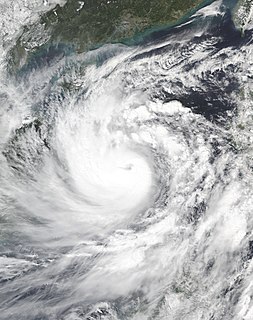
WTyphoon Goni, known in the Philippines as Super Typhoon Rolly, was an extremely powerful tropical cyclone that made landfall as a Category 5–equivalent super typhoon on Catanduanes in the Philippines and became the strongest landfalling tropical cyclone on record by 1-minute winds, eclipsing the previous record held by Haiyan and Meranti. The nineteenth named storm, ninth typhoon, and second super typhoon of the 2020 Pacific typhoon season, Goni originated as a tropical depression south of Guam on October 26. It was then named as Tropical Storm Goni on October 27. On the next day, Goni explosively intensified over the Philippine Sea, becoming a Category 5–equivalent super typhoon on October 30. Goni maintained Category 5 strength for over a day, before making landfall on Catanduanes at peak intensity, with 10-minute sustained winds of 220 km/h (140 mph), and 1-minute sustained winds of 315 km/h (195 mph), with a minimum central pressure of 905 hPa. It was the second-most intense tropical cyclone observed worldwide in 2020, after Cyclone Yasa, and one of the most intense tropical cyclones on record.
 W
WTyphoon Haishen, known in the Philippines as Typhoon Kristine, was a powerful tropical cyclone that became the first super typhoon of the 2020 Pacific typhoon season. Being also the tenth named storm and this season's fifth typhoon, Haishen's origins can be tracked back to a disorganised low pressure area situated near Guam. While the disturbance tracked south-westward and quickly organised, the JTWC issued a Tropical Cyclone Formation Alert (TCFA) on the system, and a day later, on September 1, the system became a tropical depression. The depression strengthened into Tropical Storm Haishen according to the Japan Meteorological Agency as it moved southwestward. At about 12:00 UTC on September 2, the Philippine Atmospheric, Geological and Astronomical Services Administration indicated that Haishen had entered the Philippine Area of Responsibility and was subsequently named Kristine. Later that day, Haishen became a typhoon. Intensification on September 3 was significant. Drifting northwestward into extremely favorable conditions, Haishen became a category 3-equivalent typhoon, acquiring a pinhole eye, before undergoing an eyewall replacement cycle (EWRC). Strengthening resumed soon after and the JTWC assessed wind speeds of 135 kt as it peaked as a Category 4 super typhoon and had attained a new, symmetrical, clear eye.
 W
WHurricane Hanna was the first of a record-tying six Atlantic hurricanes to make landfall in the United States during the extremely active 2020 Atlantic hurricane season, and the first to do so in Texas since Hurricane Harvey in 2017. Hanna developed from a tropical wave originating near Hispaniola. This disturbance dropped heavy rain over parts of Hispaniola, Cuba, and Florida. The wave gradually became more organized and developed into a tropical depression in the central portion of the Gulf of Mexico. The depression strengthened into a tropical storm on July 24, setting a new record for the earliest eighth-named storm in the basin, getting its name 10 calendar days before the previous record holder, Tropical Storm Harvey of 2005. Hanna steadily intensified as it drifted toward Southern Texas, becoming the season's first hurricane early on July 25. It then began to quickly strengthen before making landfall at 22:00 UTC later that day as a high-end Category 1 hurricane, with maximum sustained winds of 90 mph (150 km/h) and a minimum central pressure of 973 mbar. Hanna weakened quickly as it moved inland and turned west-southwest, eventually dissipating over Mexico on July 27.
 W
WSevere Tropical Cyclone Harold was a very powerful tropical cyclone which caused widespread destruction in the Solomon Islands, Vanuatu, Fiji, and Tonga during April 2020. It was the first Category 5 tropical cyclone in 2020. The seventh named storm of the 2019–20 Australian region cyclone season, eighth named storm, and fourth severe tropical cyclone of the 2019–20 South Pacific cyclone season, Harold was first noted as a developing tropical low within a trough of low pressure during April 1, while it was located to the east of Papua New Guinea. Over the next day, the system moved south-eastwards over the Solomon Sea, before it was classified as a tropical cyclone and named Harold by the Australian Bureau of Meteorology. The system moved into the Fiji Meteorological Service's area of responsibility on April 2 and began to explosively intensify by April 3, reaching Category 4 status by April 4 on both scales. The next day, it further strengthened into a Category 5 severe tropical cyclone, the highest rating on the Australian scale. It made landfall on Espiritu Santo on April 6. Shortly afterward, the Joint Typhoon Warning Center (JTWC) upgraded it to a Category 5-equivalent cyclone on the Saffir–Simpson scale. It maintained this status for only six hours before being downgraded back to Category 4.
 W
WTropical Storm Hernan was a small tropical cyclone that brought heavy rainfall and mudslides to southwest Mexico and made landfall in Baja California Sur as a tropical depression in late August 2020. The thirteenth tropical cyclone and eighth named storm of the below-average 2020 Pacific hurricane season, Hernan developed from a low-pressure area southwest of Mexico on August 26 as Tropical Depression Thirteen-E. The depression strengthened into Tropical Storm Hernan twelve hours after formation. Located within a high wind shear environment, Hernan barely strengthened and achieved peak intensity at 3:00 UTC on August 27 with 45 mph winds and a minimum barometric pressure of 1001 millibars. Passing just offshore Mexico, Hernan turned west and weakened to a tropical depression, and made landfall on the Baja California Peninsula on August 28, dissipating shortly thereafter. Although Hernan was located in very close proximity to Southwestern Mexico, its small size prevented the issuance of tropical storm watches or warnings in nearby coastal areas.
 W
WIntense Tropical Cyclone Herold was a powerful tropical cyclone that affected Madagascar and the Mascarene Islands in March 2020. Herold was the tenth zone of disturbed weather, ninth depression, eighth moderate tropical storm, sixth severe tropical storm, fifth tropical cyclone, and second intense tropical cyclone of the slightly above-average 2019–20 South-West Indian Ocean cyclone season. Herold formed on 13 March from a disorganized area of low pressure near Tromelin Island.
 W
WHurricane Isaias was a destructive Category 1 hurricane that caused extensive damage across the Caribbean and the East Coast of the United States while also spawning a large tornado outbreak that generated the strongest tropical cyclone-spawned tornado since Hurricane Rita in 2005. The ninth named storm and second hurricane of the extremely active and record breaking 2020 Atlantic hurricane season, Isaias originated from a vigorous tropical wave off the coast of Africa that was first identified by the National Hurricane Center on July 23. The tropical wave gradually became more organized, and obtained gale-force winds on July 28, before organizing into Tropical Storm Isaias on July 30. Isaias marked the earliest ninth named storm on record, surpassing 2005's Hurricane Irene by eight days. Isaias strengthened into a Category 1 hurricane the next day, reaching a peak intensity of 85 mph (140 km/h) and a minimum central pressure of 987 mbar. On August 1, the storm made landfall on North Andros, Bahamas and subsequently weakened to a tropical storm, before paralleling the east coast of Florida and Georgia. As Isaias approached the Carolina coastline, it reintensified back into a hurricane shortly before making landfall near Ocean Isle Beach, North Carolina, at 03:10 UTC on August 4. The storm proceeded to accelerate up the East Coast of the United States as a strong tropical storm, before transitioning into an extratropical cyclone over Quebec on August 5. Isaias's extratropical remnants persisted for another day, before dissipating on August 6.
 W
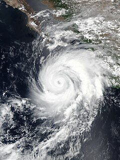
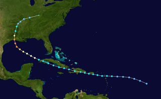
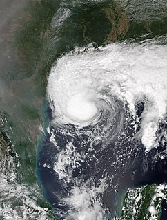
WHurricane Laura was a deadly and destructive Category 4 hurricane that tied with the 1856 Last Island hurricane as the strongest hurricane on record to make landfall in the U.S. state of Louisiana, as measured by maximum sustained winds. The twelfth named storm, fourth hurricane, and first major hurricane of the record-breaking 2020 Atlantic hurricane season, Laura originated from a large tropical wave that moved off the West African coast on August 16 and became a tropical depression on August 20. Laura intensified into a tropical storm a day later, becoming the earliest twelfth named storm on record in the North Atlantic basin, forming eight days earlier than 1995's Hurricane Luis.
 W
WHurricane Laura tied the record for the strongest hurricane to make landfall in Louisiana as measured by maximum sustained winds, along with the 1856 Last Island hurricane, and was overall the tenth-strongest hurricane to make landfall in the United States. The thirteenth tropical cyclone, twelfth named storm, fourth hurricane, and first major hurricane of the 2020 Atlantic hurricane season, Laura originated from a large tropical wave that moved off the West African coast on August 16. The tropical wave gradually organized, becoming a tropical depression on August 20. Though in only a marginally conducive environment for intensification, the depression nevertheless intensified into a tropical storm a day later, becoming the earliest twelfth named storm on record in the North Atlantic basin, forming eight days earlier than 1995's Hurricane Luis. The depression received the name Laura and tracked west-northwest towards the Lesser Antilles.
 W
WHurricane Marco was the first of two tropical cyclones to threaten the Gulf Coast of the United States within a three-day period, with the other being Hurricane Laura. The thirteenth named storm and third hurricane of the record-breaking 2020 Atlantic hurricane season, Marco developed from a fast-moving tropical wave west of the Windward Islands and south of Jamaica on August 20. The fast motion of the wave inhibited intensification initially, but as the wave slowed down and entered a more favorable environment, the system developed into a tropical depression, which in turn rapidly intensified into a strong tropical storm. Due to strong wind shear, Marco's intensification temporarily halted; however, after entering the warm waters of the Gulf of Mexico on August 23, Marco briefly intensified into a hurricane, only to quickly weaken later that evening due to another increase in wind shear. Marco made landfall near the mouth of the Mississippi River on the evening of August 24, as a weak tropical storm and subsequently weakened to a tropical depression before becoming a remnant low early on the next morning. Marco's remnants subsequently dissipated on August 26.
 W
WTyphoon Maysak, known in the Philippines as Typhoon Julian, was a deadly, damaging and powerful tropical cyclone that struck the Ryukyu Islands and the Korean Peninsula in September 2020. The third typhoon of the 2020 Pacific typhoon season, Maysak formed from a tropical disturbance. The disturbance gradually organized, receiving the name Julian from PAGASA as it became a tropical depression. As the depression strengthened, the JMA subsequently named the system Maysak. Maysak rapidly intensified into a strong typhoon before weakening and making landfall in South Korea.
 W
WHurricane Nana was a minimal Category 1 hurricane that caused moderate damage across the country of Belize in early September 2020. The sixteenth tropical cyclone, fourteenth named storm, and the fifth hurricane of the record-breaking 2020 Atlantic hurricane season, Nana originated from a tropical wave near the Lesser Antilles. The National Hurricane Center (NHC) began tracking the wave on August 27, giving it a low chance of formation. Contrary to predictions, the wave rapidly organized, though data failed to locate a closed circulation, and the system was not designated a tropical cyclone. However, the system continued organizing, and data from a hurricane hunter aircraft recorded tropical storm force winds along with a closed circulation; the NHC subsequently named the system Tropical Storm Nana on September 1. Nana rapidly intensified that day, though wind shear increased early the next day, preventing the storm from intensifying further. However, early on September 3, reconnaissance aircraft found that Nana had strengthened into a hurricane just before making landfall in Southern Belize. After landfall, it began to rapidly weaken. Early on September 4, its low-level center dissipated and it degenerated into a mid-level remnant low. The remnants moved into the Eastern Pacific, where they reformed into Tropical Storm Julio.
 W
WTropical Storm Nangka, also known in the Philippines as Tropical Depression Nika, was a weak tropical cyclone which impacted Hainan and parts of Indochina, which had been affected by Tropical Storm Linfa just days earlier. Nangka in total cause 4 deaths and 5 missing in China and Vietnam.
 W
WSevere Cyclonic Storm Nisarga was the strongest tropical cyclone to strike the Indian state Maharashtra in the month of June since 1891. It was also the first cyclone to impact Mumbai since Phyan of 2009. The third depression and second named cyclone of the annual cyclone season, Nisarga originated as a depression in the Arabian Sea and moved generally northward. On 2 June, the India Meteorological Department (IMD) upgraded the system to a cyclonic storm, assigning the name Nisarga. On the next day, Nisarga further intensified to a severe cyclonic storm and turned to the northeast, ultimately making landfall approximately 95 km (60 mi) south of Mumbai. Nisarga rapidly weakened once inland and dissipated on 4 June.
 W
WTropical Storm Noul, also known in the Philippines as Tropical Depression Leon, was a weak, but deadly tropical cyclone that impacted central Vietnam, which had been affected by Tropical Storm Sinlaku more than one month earlier. Noul originated from a tropical system in the Philippine Sea in September 15. The system was upgraded into a tropical depression later that same day by JMA, with JTWC and PAGASA following suit in 15:00 UTC, with PAGASA assigning the local name Leon to the developing tropical cyclone. As Leon was leaving the area of responsibility, Leon intensified into a tropical storm and was assigned the international name Noul by JMA. Noul would make landfall between Quảng Trị and Thừa Thiên-Huế provinces in September 18 before degenerating into a remnant low over Thailand later that day.
 W
WHurricane Paulette was the first tropical cyclone to make landfall in Bermuda since Gonzalo in 2014. The sixteenth named storm and sixth hurricane of the extremely active 2020 Atlantic hurricane season, Paulette developed from a tropical wave on September 7. Due to relatively favorable conditions, Paulette gradually strengthened into a strong tropical storm, though an increase in wind shear caused it to weaken. Wind shear continued to increase to the south of the system, but despite the shear, Paulette unexpectedly strengthened back into a strong tropical storm on September 11, with deep convection located just north of the center. A dry air inclusion caused the cyclone's structure to become disheveled on September 12, though Paulette quickly recovered and strengthened into a hurricane at 03:00 UTC on September 13. Paulette then developed a closed eyewall and a clear eye as it steadily strengthened and moved towards Bermuda. Early on September 14th, Paulette made landfall in northeastern Bermuda as a Category 1 hurricane while making a sharp turn to the north. It then further strengthened into a Category 2 hurricane as it moved away from the island, reaching its peak intensity on September 14 with winds of 105 mph (165 km/h) and a pressure of 965 mbar. On the evening of September 15, it began to weaken and undergo extratropical transition, which it completed on September 16. Paulette's extratropical remnants persisted and moved southwards then eastwards, and eventually regenerated into a tropical storm early on September 22 south of the Azores. This proved to be short lived, however, as the storm quickly weakened and became post-tropical again only a day later. The remnants persisted for another week before dissipating south of the Azores on September 30.
 W
WHurricane Sally was a destructive Atlantic hurricane which became the first hurricane to make landfall in the U.S. state of Alabama since Ivan in 2004, coincidentally on the same date. The eighteenth named storm, and seventh hurricane of the extremely active 2020 Atlantic hurricane season, Sally formed out of an area of disturbed weather which was first monitored over the Bahamas on September 10. The system grew a broad area of low-pressure on September 11, and was designated as a tropical depression late that day. Early the next day, the depression made landfall at Key Biscayne, and subsequently strengthened into Tropical Storm Sally that afternoon. Moderate northwesterly shear prevented significant intensification for the first two days, but convection continued to grow towards the center and Sally slowly intensified. On September 14, a center reformation into the center of the convection occurred, and data from a hurricane hunter reconnaissance aircraft showed that Sally rapidly intensified into a strong Category 1 hurricane. It further intensified into a Category 2 hurricane that evening. However, an increase in wind shear and upwelling of colder waters weakened Sally slightly back down to Category 1 on September 15. Despite this increase in wind shear, it unexpectedly re-intensified, reaching Category 2 status again early on September 16 before making landfall at peak intensity at 09:45 UTC on September 16 near Gulf Shores, Alabama, with maximum sustained winds of 105 mph (165 km/h). The storm rapidly weakened after landfall, becoming a remnant low early the next day.
 W
WTyphoon Saudel, known in the Philippines as Typhoon Pepito, was a typhoon which affected the Philippines, Vietnam and Southern China in October 2020. The seventeenth tropical storm and seventh typhoon of the 2020 Pacific typhoon season, Saudel formed from a tropical disturbance east of the Philippines. The disturbance gradually organized and crossed the Philippines as a tropical storm. Once the system emerged into the South China Sea, it began to rapidly organize and intensify, becoming a typhoon early on October 22.
 W
WTropical Storm Sinlaku was a weak but deadly tropical cyclone that impacted Vietnam, Thailand and Laos in August 2020. Beginning as a tropical depression on July 31 in the South China Sea, Sinlaku was the fifth storm of the 2020 Pacific typhoon season. It gradually organized as it took a slow west-northwest course, strengthening into a tropical storm the following day despite its monsoonal structure. The storm subsequently made landfall in Vietnam as a broad but weak tropical storm. Persistent land interaction weakened Sinlaku, leading to its dissipation on August 3.
 W
WHurricane Teddy was a large and powerful Cape Verde hurricane that was the fourth-largest Atlantic hurricane by diameter of gale-force winds recorded and produced large swells along the coast of the Eastern United States and Atlantic Canada in September 2020. The twentieth tropical depression, nineteenth named storm, eighth hurricane, and second major hurricane of the record-breaking 2020 Atlantic hurricane season, Teddy initially formed from a tropical depression that developed from a tropical wave on September 12. Initially, the depression's large size and moderate wind shear kept it from organizing, but it eventually intensified into Tropical Storm Teddy on September 14. After steadily intensifying for about a day, the storm rapidly became a Category 2 hurricane on September 16 before moderate wind shear caused the storm to fluctuate in intensity. It then rapidly intensified again on September 17 and became a Category 4 hurricane. Internal fluctuations and eyewall replacement cycles then caused the storm to fluctuate in intensity before it weakened some as it approached Bermuda. After passing east of the island as a Category 1 hurricane on September 21, Teddy restrengthened back to Category 2 strength due to baroclinic forcing. It weakened back down to Category 1 hurricane the next day before becoming a post-tropical as it approached Atlantic Canada early on September 23. It then weakened to a gale-force low and made landfall in Nova Scotia with winds of 65 mph. It executed a large loop as it accelerated first northward then eastward north of Newfoundland, briefly strengthening back to a storm-force low before weakening again and losing its identity on September 27.
 W
WSevere Tropical Cyclone Tino was a tropical cyclone which itself and an associated convergence zone caused significant damage across ten island nations in the South Pacific Ocean during January 2020. First noted as a tropical disturbance during January 11, to the southwest of Honiara in the Solomon Islands, the system gradually developed over the next few days as it moved eastwards in between the Solomon Islands and Vanuatu prior to being named Tino as it approached Fiji during January 16. Continuing to track south-eastward, Tino continued strengthening as it passed near Fiji, bringing copious amounts of rainfall to the area. Whilst losing latitude, the system continued to strengthen and peaked as a category 3 tropical cyclone on January 17, with signs of an eye forming. Shortly after peak intensity, Tino was impacted by high wind shear and decreasing sea surface temperatures, triggering a weakening trend. Tino moved out of the tropics shortly thereafter and became an extratropical cyclone during January 19.
 W
WSevere Tropical Storm Chalane was a tropical cyclone that made landfall in Madagascar, Mozambique, and Zimbabwe in December 2020. As the fourth tropical depression, third named storm, and second severe tropical storm of the 2020-21 South-West Indian Ocean cyclone season, Chalane developed out of a zone of disturbed weather which was first monitored RSMC La Réunion on 19 December. Despite conditions slowly become unfavorable, the system formed into a tropical depression on 23 December due to the presence of a Kelvin wave and an equatorial Rossby wave, as well as warm sea surface temperatures. The depression soon strengthened into Tropical Storm Chalane on the following day.
 W
WTropical Storm Krovanh, known in the Philippines as Tropical Depression Vicky, was a tropical cyclone which caused deadly flooding in the Philippines during December 2020. The thirty-first depression and 23rd named storm of the 2020 Pacific typhoon season, Krovanh originated from a tropical depression which was first monitored by PAGASA, late on December 17. The system strengthened with PAGASA naming it Vicky, meanwhile the JMA monitored it as a low pressure area. The depression then made several landfalls over the Philippines on December 18–19, before moving out of the PAR on December 20 as it strengthened into a tropical storm according to the JMA and was named Krovanh. However, Krovanh was downgraded back to a tropical depression the next day, with the JTWC issuing their final advisory on December 22.
 W
WTyphoon Bavi, known in the Philippines as Severe Tropical Storm Igme, was a powerful tropical cyclone that made landfall in North Korea in August 2020. The eighth named storm and third typhoon of the 2020 Pacific typhoon season, Bavi formed from a low pressure area depression on August 21 to the north of the Philippines and strengthened into a tropical storm on August 22. Bavi gradually strengthened as it skirted Taiwan and Okinawa, and became a typhoon on August 24. Passing over warm waters, Bavi turned to northwest and reached its peak intensity near Jeju Island on August 26. Thereafter, increasing wind shear and cooler waters caused Bavi to quickly weaken. Bavi made landfall in North Korea on August 27, and became an extratropical cyclone shortly thereafter.
 W
WTyphoon Hagupit, known in the Philippines as Severe Tropical Storm Dindo, was a Category 1 typhoon that heavily impacted Eastern China and South Korea in August 2020. It was the fourth named storm and the second typhoon of the annual typhoon season. The JMA began monitoring a tropical depression that developed in the Philippine Sea on July 30, with PAGASA assigning the name “Dindo” to the storm, later that day it strengthened into a tropical storm, according to the JMA. PAGASA issued its final advisory on Dindo early on August 3, as it moved out of their area of responsibility. Hagupit intensified into a typhoon on August 3, before making landfall in Wenzhou, China at 19:30 UTC that day at peak intensity. Hagupit subsequently weakened over China, before degenerating into an extratropical low on August 5. Hagupit's remnants persisted for another several days, as the storm moved eastward, before dissipating south of Alaska on August 14.
 W
WTyphoon Molave, known in the Philippines as Typhoon Quinta, was a strong tropical cyclone that caused widespread damage in the Philippines and Indochina in late October 2020, and became the strongest to strike the South Central Coast of Vietnam since Damrey in 2017. The eighteenth named storm and eighth typhoon of the annual typhoon season, Molave originated from a tropical depression that formed on October 23 east of Palau. At 15:00 UTC the next day, the depression was upgraded into Tropical Storm Molave as it drifted generally northwestward. Molave soon became a typhoon on October 25 as it turned west, shortly before making five landfalls in central Philippines. After striking the Philippines, Molave entered the South China Sea and began to re-intensify. Molave attained its peak intensity on October 27 before weakening again as it approached Vietnam. The typhoon struck Vietnam on October 28, before rapidly weakening as it headed further into Indochina. Molave later dissipated on October 30, over Myanmar.
 W
WTyphoon Vamco, known in the Philippines as Typhoon Ulysses, was a powerful and deadly Category 4-equivalent typhoon that struck the Philippines and Vietnam. It also caused the worst flooding in Metro Manila since Ketsana in 2009. The twenty-second named storm and tenth typhoon of the 2020 Pacific typhoon season, Vamco originated as a tropical depression northwest of Palau, where it slowly continued its northwest track until it made landfall in Quezon. After entering the South China Sea, Vamco further intensified in the South China Sea until it made its last landfall in Vietnam.
 W
WTyphoon Vongfong, known in the Philippines as Typhoon Ambo, was a strong tropical cyclone that impacted the Philippines in May 2020. Beginning as a tropical depression on May 10 east of Mindanao, Vongfong was the first storm of the 2020 Pacific typhoon season. It gradually organized as it took a slow northward course, strengthening into a tropical storm on May 12 and curving west thereafter. The next day, Vongfong entered a period of rapid intensification, becoming a typhoon and attaining 10-minute maximum sustained winds of 150 km/h (100 mph). The storm made landfall at this intensity near San Policarpo, Eastern Samar, at 04:15 UTC on May 14. The system tracked across Visayas and Luzon, making a total of seven landfalls. Persistent land interaction weakened Vongfong, leading to its degeneration into a tropical depression over the Luzon Strait on May 17.
 W
WSubtropical Storm Alpha was a unique subtropical cyclone that made landfall in Portugal, the first ever recorded occurrence for the country. The system was also the easternmost-forming (sub)tropical cyclone on record in the basin. The twenty-fourth cyclone and twenty-second named storm of the extremely active and record-breaking 2020 Atlantic hurricane season, Alpha originated from a large non-tropical low that was first monitored by the National Hurricane Center on 15 September. Initially not anticipated to transition into a tropical cyclone, the low gradually tracked south-southeastward for several days with little development. By 18 September, the low began to separate from its frontal features and exhibited sufficient organization to be classified as a subtropical cyclone as it approached the Iberian Peninsula, becoming a subtropical storm later that day. Alpha made landfall just north of Lisbon, Portugal during the evening of 18 September, then rapidly weakened and became a remnant low early the following day, before dissipating on 20 September.
 W
WTropical Storm Beta was a tropical cyclone that brought heavy rainfall, flooding, and severe weather to the Southeastern United States in September 2020. The twenty-second tropical depression and twenty-third tropical or subtropical storm of the record-breaking 2020 Atlantic hurricane season, Beta originally formed from a trough of low pressure that developed in the northeastern Gulf of Mexico on September 10. The low moved slowly southwestward, with development hampered initially by the development of nearby Hurricane Sally. After Sally moved inland over the Southeastern United States and weakened, the disturbance became nearly stationary in the southwestern Gulf, where it began to organize. By September 16, the storm had gained a low-level circulation center and enough organization to be designated as Tropical Depression Twenty-Two. The system held its intensity for a day under the influence of strong wind shear and dry air before attaining tropical storm strength. It slowly moved northward and intensified to a mid-range tropical storm before dry air and wind shear halted its intensification. Beta then became nearly stationary on September 19, before starting to move west towards the Texas coast the next day, weakening as it approached. On September 21, Beta made landfall near Matagorda Peninsula, Texas as a minimal tropical storm. It subsequently weakened to a tropical depression the next day before becoming a post-tropical early on September 23. Its remnants moved northeastward before the center elongated and merged with a cold front early on September 25.
 W
WHurricane Zeta was the record-tying sixth hurricane to make landfall in the United States and the record fifth named storm to strike Louisiana in 2020. The system was also the first tropical cyclone since Hurricane Sandy in 2012 to produce accumulating snow and one of only four tropical cyclones since 1804 to do so. The twenty-seventh named storm and eleventh hurricane of the exceptionally active 2020 Atlantic hurricane season, Zeta formed from a broad area of low pressure that formed in the western Caribbean Sea on October 19. After battling wind shear, the quasi-stationary low organized into Tropical Depression Twenty-Eight on October 24. The system strengthened into Tropical Storm Zeta early on October 25 before becoming a hurricane the next day as it began to move northwestward. Hurricane Zeta made landfall in the Yucatán Peninsula late on October 26 and weakened while inland to a tropical storm, before moving off the northern coast of the peninsula on October 27. After weakening due to dry air, Zeta reorganized and became a hurricane again, and eventually a Category 2 hurricane, as it turned northeastward approaching the U.S. Gulf Coast on October 28. It continued to strengthen until it reached its peak intensity of 110 mph (175 km/h) and a minimum pressure of 970 mbar (28.64 inHg) as it made landfall in Cocodrie, Louisiana, that evening. Zeta gradually weakened as it accelerated northeastward, and became post-tropical on October 29, as it moved through central Virginia. After bringing accumulating snow to parts of New England, Zeta accelerated across the north Atlantic, re-intensifying into a hurricane-force extratropical cyclone as it impacted the United Kingdom on November 1 and 2.
 W
WHurricane Eta was a devastating Category 4 hurricane that wreaked havoc across parts of Central America in early November 2020. The record-tying twenty-eighth named storm, twelfth hurricane and fifth major hurricane of the extremely active 2020 Atlantic hurricane season, Eta originated from a vigorous tropical wave in the eastern Caribbean Sea on October 31. The system rapidly organized as it progressed west, with the cyclone ultimately becoming a Category 4 hurricane on November 3. With a peak intensity of 150 mph (240 km/h) and 923 mbar, it was the third most intense November Atlantic hurricane on record, behind the 1932 Cuba hurricane, and Hurricane Iota just two weeks later. Some weakening took place as the system made landfall near Puerto Cabezas, Nicaragua, late that same day. Eta rapidly weakened to a tropical depression as it meandered across Central America for two days before moving north over water. It later reorganized over the Caribbean as it accelerated toward Cuba on November 7. Over the next five days, the system moved erratically, moving through the Florida Keys and stalling in the southern Gulf of Mexico, its intensity fluctuating along the way. After briefly regaining hurricane strength it weakened once more and accelerated across the Southeastern United States on November 12. It soon became extratropical and dissipated off the Eastern United States the next day.
 W
WHurricane Iota was the latest Atlantic hurricane to attain Category 5 intensity and only the second Category 5 Atlantic hurricane to occur within the month of November on record—the other being the 1932 Cuba hurricane. Iota caused severe damage to areas of Central America already devastated by Hurricane Eta just less than two weeks prior. The 31st and final tropical cyclone, 30th named storm, 13th hurricane, and sixth major hurricane of the record-breaking 2020 Atlantic hurricane season, Iota originated as a tropical wave that moved into the Eastern Caribbean on November 10. Over the next few days, the wave began to become better organized and by November 13, it developed into a tropical depression north of Colombia. The depression strengthened into Tropical Storm Iota six hours later. The storm was initially impacted by some wind shear, but a center relocation and relaxed shear allowed Iota to quickly strengthen into a hurricane on November 15, after which it underwent explosive intensification, becoming a Category 5 hurricane the following day. This made 2020 the fifth consecutive Atlantic hurricane season since 2016 to feature at least one Category 5 hurricane. After weakening slightly, Iota made landfall in northeastern Nicaragua as a high-end Category 4 hurricane, becoming the strongest recorded hurricane to make landfall in Nicaragua in November. Iota then rapidly weakened as it moved inland, dissipating on November 18.