 W
WDuring 2015, tropical cyclones formed within seven different tropical cyclone basins, located within various parts of the Atlantic, Pacific and Indian Oceans. During the year, a total of 134 tropical cyclones had formed this year to date. 92 tropical cyclones had been named by either a Regional Specialized Meteorological Center (RSMC) or a Tropical Cyclone Warning Center (TCWC).
 W
WThe 2015 Atlantic hurricane season was the last of three consecutive below average Atlantic hurricane seasons. It produced twelve tropical cyclones, eleven named storms, four hurricanes, and two major hurricanes. The Accumulated Cyclone Energy (ACE) for the season was 68% of the long-term median value. The hurricane season officially began on June 1, 2015, and ended on November 30, 2015. These dates historically describe the period each year when most tropical cyclones form in the North Atlantic basin. However, the first named storm, Ana, developed on May 8, nearly a month before the official start of the season, the first pre-season cyclone since Beryl in 2012 and the earliest since Ana in 2003. The formation of Ana marked the first in a series of six consecutive seasons with pre-season activity, spanning from 2015 to 2020. The season concluded with Kate transitioning into an extratropical cyclone on November 11, almost three weeks before the official end.
WThe 2015 Atlantic hurricane season was an event in the annual hurricane season in the north Atlantic Ocean. It was the third consecutive year to feature below-average tropical cyclone activity, with eleven named storms. The season officially began on June 1, 2015 and ended on November 30, 2015. These dates, adopted by convention, historically describe the period in each year when most tropical systems form. However, systems can and do form outside these dates, as did the season's first storm, Tropical Storm Ana, which developed on May 8; the season's final storm, Hurricane Kate, lost its tropical characteristics on November 11.
 W
WThe 2014–15 Australian region cyclone season was a slightly below average tropical cyclone season. The season officially ran from 1 November 2014, to 30 April 2015, however, a tropical cyclone could form at any time between 1 July 2014, and 30 June 2015, and would count towards the season total. During the season, tropical cyclones were officially monitored, by one of the five Tropical Cyclone Warning Centres (TCWCs) that are operated in this region.
 W
WThe 2015–16 Australian region cyclone season was the least active tropical cyclone season since reliable records started during 1969, with only three named tropical cyclones developing in the region. Reasons for the low activity during the year included a positive Indian Ocean Dipole occurring and the 2014–16 El Niño event. Ahead of the season starting; the Australian Bureau of Meteorology predicted that there was a 91% chance that the season would be below average. As the 2015–16 tropical cyclone year opened on 1 July 2015, the newly named Tropical Cyclone Raquel moved south-westward into the Australian region. Over the next couple of days, the system meandered around 160°E and moved through the Solomon Islands, before it was last noted on 5 July. The basin subsequently remained quiet with only several weak tropical lows developing, before the first named tropical cyclone of the season was named Stan during 29 January 2016.
 W
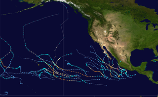
WThe 2015 Pacific hurricane season is the second-most active Pacific hurricane season on record, with 26 named storms, only behind the 1992 season. A record-tying 16 of those storms became hurricanes, and a record 11 storms further intensified into major hurricanes throughout the season. The Central Pacific, the portion of the Northeast Pacific Ocean between the International Date Line and the 140th meridian west, had its most active year on record, with 16 tropical cyclones forming in or entering the basin. Moreover, the season was the third-most active season in terms of accumulated cyclone energy, amassing a total of 287 units. The season officially started on May 15 in the Eastern Pacific and on June 1 in the Central Pacific; they both ended on November 30. These dates conventionally delimit the period of each year when most tropical cyclones form in the Northeast Pacific basin. However, the formation of tropical cyclones is possible at any time of the year. This was shown when a tropical depression formed on December 31. The above-average activity during the season was attributed in part to the very strong 2014–16 El Niño event.
WThe 2015 Pacific hurricane season was the second-most active Pacific hurricane season on record, and featured the strongest tropical cyclone ever observed in the Western Hemisphere: Hurricane Patricia. The season officially started on May 15 in the Eastern Pacific—east of 140°W—and on June 1 in the Central Pacific—between the International Date Line and 140°W—and ended on November 30. These dates typically cover the period of each year when most tropical cyclones form in the Northeastern Pacific tropical cyclone basin. The season's first storm, Hurricane Andres, developed on May 28; the season's final storm, Tropical Depression Nine-C, dissipated on December 31, well after the official end of the season.
 W
WDeep Depression ARB 02 was a weak tropical cyclone which brought heavy rains and flooding to the Indian state of Gujarat in June 2015. It was the third tropical cyclone and second deep depression of the 2015 North Indian Ocean cyclone season.
 W
WFollowing heavy rain, Gujarat state of India was affected by the flood in July 2015. The flood resulted in at least 72 deaths.
 W
WThe 2015 North Indian Ocean cyclone season was an event in the annual cycle of tropical cyclone formation. The North Indian Ocean cyclone season has no official bounds, but cyclones tend to form between months of April and December, with the peak from May to November. These dates conventionally delimit the period of each year when most tropical cyclones form in the northern Indian Ocean.
WThe 2015 North Indian Ocean cyclone season was a below-average tropical cyclone season which featured the highest number of deaths since the 2010 season. Despite inactivity in the Bay of Bengal caused by the ongoing El Niño, the season produced an above-average number of tropical cyclones in the Arabian Sea. The first storm of the season, Ashobaa, formed on 7 June, while the final storm of the season, Megh, ultimately dissipated on 10 November.
 W
WThe 2015 South India floods resulted from heavy rainfall generated by the annual northeast monsoon in November–December 2015. They affected the Coromandel Coast region of the South Indian states of Tamil Nadu and Andhra Pradesh. More than 500 people were killed and over 1.8 million people were displaced. With estimates of damages and losses ranging from nearly ₹200 billion (US$3 billion) to over ₹1 trillion (US$14 billion), the floods were the costliest to have occurred in 2015, and were among the costliest natural disasters of the year.
 W
WThe 2014–15 South Pacific cyclone season was a slightly-below average tropical cyclone season, with five tropical cyclones occurring within the basin between 160°E and 120°W. The season officially ran from November 1, 2014 to April 30, 2015. During the season, tropical cyclones were officially monitored by the Regional Specialized Meteorological Center (RSMC) in Nadi, Fiji and the Tropical Cyclone Warning Centers in Brisbane, Australia and Wellington, New Zealand. The United States Armed Forces through the Joint Typhoon Warning Center (JTWC) also monitored the basin and issued unofficial warnings for American interests. RSMC Nadi attaches a number and an F suffix to tropical disturbances that form in or move into the basin while the JTWC designates significant tropical cyclones with a number and a P suffix. RSMC Nadi, TCWC Wellington and TCWC Brisbane all use the Australian Tropical Cyclone Intensity Scale and estimate windspeeds over a period of ten minutes, while the JTWC estimated sustained winds over a 1-minute period, which are subsequently compared to the Saffir–Simpson hurricane wind scale (SSHWS).
 W
WThe 2015–16 South Pacific cyclone season was one of the most disastrous South Pacific tropical cyclone seasons on record, with a total of 50 deaths and $1.405 billion in damage. Throughout the season, 8 systems attained tropical cyclone status, whilst 5 became severe tropical cyclones. The most notable cyclone of the season by far was Winston, which attained a minimum pressure of 884 hPa, and maximum ten-minute sustained winds of 175 mph (280 km/h), making it the most intense tropical cyclone on record in the Southern Hemisphere. Winston went on to devastate Fiji, causing $1.4 billion in damage and 44 deaths across the country.
 W
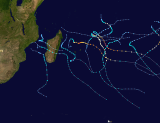
WThe 2014–15 South-West Indian Ocean cyclone season was an above average event in tropical cyclone formation. It began on November 15, 2014, and ended on April 30, 2015, with the exception for Mauritius and the Seychelles, for which it ended on May 15, 2015. These dates conventionally delimit the period of each year when most tropical and subtropical cyclones form in the basin, which is west of 90°E and south of the Equator. Tropical and subtropical cyclones in this basin are monitored by the Regional Specialised Meteorological Centre in Réunion.
 W
WThe 2015–16 South-West Indian Ocean cyclone season was a slightly below average event in tropical cyclone formation. The annual cyclone season began on November 15, 2015, with the first storm, Annabelle, forming four days following. The final and strongest storm, Fantala, dissipated on April 23, 2016, a week before the season ended on April 30 for most of the region. In Mauritius and the Seychelles, the cyclone season ended half a month later, on May 15. The season's activity was influenced by an ongoing El Niño, and a positive Indian Ocean Dipole.
 W
WThe 2015 Pacific typhoon season was a slightly above average season that produced 27 tropical storms, 18 typhoons, and nine super typhoons. The season ran throughout 2015, though most tropical cyclones typically develop between May and November. The season's first named storm, Mekkhala, developed on January 15, while the season's last named storm, Melor, dissipated on December 17. The season saw at least one named tropical system forming in each of every month, the first time since 1965. Similar to the previous season, this season saw a high number of super typhoons. Accumulated cyclone energy (ACE) during 2015 was extremely high, the second highest since the 1970, and the 2015 ACE has been attributed in part to anthropogenic warming.
 W
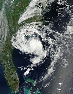
WTropical Storm Ana was the earliest tropical cyclone to make landfall in the United States in any given year in the Atlantic basin. A relatively rare pre-season system, Ana was the first tropical storm of the 2015 Atlantic hurricane season. It developed as a subtropical cyclone from a non-tropical low north of the Bahamas, and intensified to attain peak winds of 60 mph (97 km/h) before transitioning into a fully tropical cyclone early on May 9. Sustained in part by the warm waters of the Gulf Stream, Ana made landfall along the northeast coast of South Carolina early the next morning, becoming the earliest U.S. landfalling system on record. Overall, damage from the storm was minor. Heavy rainfall and gusty winds affected parts of the Carolinas, and some vulnerable beaches endured coastal flooding and several feet of erosion. Gusty winds damaged trees and powerlines, causing sporadic power outages, and a weak tornado was reported in association with Ana. In North Carolina, two deaths—one direct and one indirect—were attributed to the storm.
 W
WTropical Storm Bavi, known in the Philippines as Tropical Storm Betty, influenced the trade winds over the Pacific Ocean and was partially responsible for one of the strongest trade wind reversals ever observed. The system was first noted as a tropical disturbance during March 8, 2015, while it was located to the southeast of Kwajalein Atoll in the Marshall Islands. Over the next couple of days the system moved north-westwards through the Marshall Islands, before it was classified as a tropical depression during March 10. The system subsequently moved north-westwards and continued to develop further, before it was classified as the third tropical storm of the 2015 Pacific typhoon season and named Bavi by the Japan Meteorological Agency (JMA) during March 11. After continuing its north-westwards movement, the system peaked as a tropical storm during March 14, before it started to weaken as it approached the Mariana Islands. The system subsequently passed over Guam during the next day, before continuing its west-northwestwards movement as it gradually weakened over the next few days. The system entered the Philippine area of responsibility, where it was named Betty by PAGASA during March 17 as the system weakened into a tropical depression. The system was subsequently last noted during March 21, as it dissipated over the Philippines.
 W
WTropical Storm Bill was a tropical cyclone that produced widespread rainfall across East Texas, Oklahoma, the Midwest, and Mid-Atlantic. The second named storm of the season, Bill developed from a broad area of low pressure over the northwestern Gulf of Mexico on June 16. Because the system was already producing tropical storm force winds, it was immediately classified as Tropical Storm Bill. Initially continuing northwestward, Bill re-curved west-northwestward later on June 16. Around 12:00 UTC, the storm peaked with maximum sustained winds of 60 mph (95 km/h). Just under five hours later, Bill made landfall near on Matagorda Island, Texas, at the same intensity. The cyclone weakened to a tropical depression and turned northward early on June 17. Bill remained a tropical cyclone until late on June 18, when it degenerated into a remnant low. The remnant low moved east-northeastward until dissipating over West Virginia on June 21.
 W
WHurricane Blanca in 2015 was the earliest recorded tropical cyclone to make landfall on the Baja California Peninsula. Forming as a tropical depression on May 31, Blanca initially struggled to organize due to strong wind shear. However, once this abated, the system took advantage of high sea surface temperatures and ample moisture. After becoming a tropical storm on June 1, Blanca rapidly intensified on June 2–3, becoming a powerful Category 4 hurricane on the Saffir–Simpson hurricane wind scale; maximum sustained winds reached 145 mph (230 km/h) at this time. The hurricane's slow motion resulted in tremendous upwelling of cooler water, resulting in a period of weakening. Blanca gradually recovered from this and briefly regained Category 4 status on June 6 as it moved generally northwest toward the Baja California peninsula. Cooler waters and increased shear again prompted weakening on June 7 and the system struck Baja California Sur on June 8 as a weak tropical storm. It quickly degraded to a depression and dissipated early the next day.
 W
WHurricane Carlos was an unusually small tropical cyclone which affected the western coast of Mexico in June 2015. Forming as the third named storm and hurricane of the annual hurricane season, Carlos developed from a trough first noted by the National Hurricane Center on June 7. The disturbance gradually organized and was designated as a tropical depression three days later while south of the Mexican Pacific coast. Drifting slowly northwestward, the depression was upgraded further to a tropical storm. Although persistent wind shear and dry air hampered intensification early on, Carlos strengthened into a hurricane on June 13 after moving into a more favorable environment. However, the return of dry air and upwelling of cooler waters caused the system to deteriorate into a tropical storm. Paralleling the Mexican coast, Carlos later regained hurricane intensity on June 15 and attained peak winds of 90 mph (150 km/h) a day later. The reprieve was brief, however, as the onset of wind shear, land interaction, and dry air afterward led to rapid weakening. On June 17, Carlos degenerated into a remnant area of low pressure, having made landfall in Jalisco earlier that day. By the morning of June 18, Carlos was declared to have completely dissipated.
 W
WTyphoon Chan-hom, known in the Philippines as Typhoon Falcon, was a large, powerful and long-lived tropical cyclone that affected most countries in the western Pacific basin. The ninth named storm of the 2015 Pacific typhoon season, Chan-hom developed on June 29 from a westerly wind burst that also spawned Tropical Cyclone Raquel in the southern hemisphere. Chan-hom slowly developed while moving to the northwest, aided by warm waters but disrupted by wind shear. The storm meandered near the Northern Marianas Islands, passing over the island of Rota before beginning a steady northwest track. While near the island, the storm dropped heavy rainfall on neighboring Guam, causing flooding and minor power outages. Chan-hom intensified into a typhoon on July 7, and two days later passed between the Japanese islands of Okinawa and Miyako-jima. There, strong winds left 42,000 people without power, while 27 people were injured. Around that time, the storm caused a surge in the monsoon trough, in conjunction with Tropical Storm Linfa, which caused flooding and killed 16 people in the Philippines.
 W
WExtremely Severe Cyclonic Storm Chapala was a powerful tropical cyclone that caused moderate damage in Somalia and Yemen during November 2015. Chapala was the third named storm of the 2015 North Indian Ocean cyclone season. It developed as a depression on 28 October off western India, and strengthened a day later into a cyclonic storm. Chapala then rapidly intensified amid favorable conditions. On 30 October, the India Meteorological Department (IMD) estimated that Chapala attained peak three-minute sustained winds of 215 km/h (130 mph). The American-based Joint Typhoon Warning Center (JTWC) estimated sustained winds of 240 km/h (150 mph), making Chapala among the strongest cyclones on record in the Arabian Sea. After peak intensity, Chapala skirted the Yemeni island of Socotra on 1 November, becoming the first hurricane-force storm there since 1922. High winds and heavy rainfall resulted in an island-wide power outage, and severe damage was compounded by Cyclone Megh, which struck Yemen a week later.
 W
WSevere Tropical Storm Chedza was a deadly tropical cyclone that struck Madagascar in January 2015. It formed from the intertropical convergence zone and moved over Mozambique, After moving open waters, the system began organizing on January 14, becoming Tropical Storm Chedza two days later. It quickly intensified over the Mozambique Channel due to warm waters and favorable conditions, and the storm attained peak 10 minute sustained winds of 100 km/h (65 mph) on January 16. That day, Chedza moved ashore western Madagascar between Belo sur Mer and Morondava, and it quickly crossed the island while weakening. The storm briefly re-intensified, passing southwest of Réunion before turning to the southeast. Chedza became extratropical on January 19, and was last noted two days later.
 W
WHurricane Danny in was the first major hurricane to develop between the Lesser Antilles and Western Africa since Hurricane Julia in 2010. The fourth tropical cyclone, and first hurricane of the 2015 Atlantic hurricane season, Danny originated from a well-defined tropical wave that emerged over the Atlantic Ocean on August 14. Traveling west, the system gradually coalesced into a tropical depression by August 18. After becoming a tropical storm later that day, dry air slowed further development. On August 20–21, dry air became removed from the system, and Danny rapidly intensified into a Category 3 hurricane on the Saffir–Simpson hurricane wind scale. Its peak was short-lived as wind shear soon increased and prompted significant weakening. Degrading to a tropical storm by August 23, Danny approached the Lesser Antilles. It degenerated into a tropical wave as it traversed the archipelago on August 24 and was last noted over Hispaniola the following day.
 W
WTyphoon Dolphin was a powerful tropical cyclone that produced the first typhoon-force winds on Guam since Typhoon Pongsona in 2002. The seventh named storm of the 2015 Pacific typhoon season, Dolphin formed on May 6 in the vicinity of the Federated States of Micronesia (FSM). Moving eastward at first, the storm slowly organized before beginning a north and west-northwest trajectory. Dolphin intensified into a typhoon before passing between Guam and Rota on May 15, producing typhoon-force winds on both islands. It later rapidly intensified as it curved to the north. The American-based Joint Typhoon Warning Center (JTWC) designated Dolphin as a super typhoon, while the Japan Meteorological Agency (JMA) estimated 10 minute sustained winds of 185 km/h (115 mph). Dolphin turned to the northeast and weakened, becoming extratropical on May 20 and exiting the western Pacific basin on May 24.
 W
WTropical Storm Erika was one of the deadliest and most destructive natural disasters in Dominica since Hurricane David in 1979. The fifth named storm of the 2015 Atlantic hurricane season, Erika developed from a westward-moving tropical wave while well east of the Lesser Antilles. Hostile conditions, including dry air and wind shear, inhibited significant development, and Erika failed to acquire sustained winds beyond 50 mph (80 km/h). Contrary to predictions of a northwesterly recurvature, the cyclone persisted on a westerly course and passed through the Leeward Islands and emerged over the Caribbean Sea on August 27. Erika succumbed to adverse conditions the following day, dissipating as a tropical cyclone near the Dominican Republic. The remnant system persisted for several more days, ultimately moving across the Gulf of Mexico, before dissipating over Georgia on September 3.
 W
WSevere Tropical Storm Etau caused extensive and destructive floods across eastern Japan during early September 2015. Originating from a tropical disturbance near Guam on September 2, Etau was first classified a tropical depression on September 5. Tracking generally north, the cyclone gradually intensified and reached its peak strength with winds of 95 km/h (60 mph) on September 8. The following day, Etau made landfall in Honshu, Japan. It subsequently transitioned into an extratropical cyclone later that day over the Sea of Japan.
 W
WTyphoon Goni, known in the Philippines as Typhoon Ineng, was a powerful tropical cyclone that affected much of East Asia in late August 2015. Developing in tandem with Typhoon Atsani to its east, Goni formed on August 13, and passed through the Mariana Islands two days later. By that time, radar imagery showed a formative eye, signaling an rapidly intensifying storm. Goni evolved into an intense typhoon in the Philippine Sea before weakening and stalling north of Luzon. The typhoon re-intensified and attained peak winds of 185 km/h (115 mph) on August 23 while moving through the southern Ryukyu Islands. Goni weakened slightly and moved across the Japanese island of Kyushu. The tropical cyclone transitioned into an extratropical cyclone in the Sea of Japan on August 25, crossed into eastern Russia and China a day later, and dissipated on August 30.
 W
WTyphoon Halola, known in the Philippines as Typhoon Goring, was a small but long-lived tropical cyclone in July 2015 that traveled 7,640 km (4,750 mi) across the Pacific Ocean. The fifth named storm of the 2015 Pacific hurricane season, Halola originated from a Western Pacific monsoon trough that had expanded into the Central Pacific by July 5. Over the next several days, the system waxed and waned due to changes in wind shear before organizing into a tropical depression on July 10 while well southwest of Hawaii. The depression strengthened into Tropical Storm Halola on the next day as it traveled westward. Halola crossed the International Date Line on July 13 and entered the Western Pacific, where it was immediately recognized as a severe tropical storm. The storm further strengthened into a typhoon over the next day before encountering strong wind shear on July 16, upon which it quickly weakened into a tropical depression as it passed south of Wake Island. However, the shear relaxed on July 19, allowing Halola to reintensify. On July 21, Halola regained typhoon status and later peaked with 10-minute sustained winds of 150 km/h (90 mph) and a minimum pressure of 955 hPa. From July 23 onward, increasing wind shear and dry air caused Halola to weaken slowly. The system fell below typhoon intensity on July 25 as it began to recurve northwards. Halola made landfall over Kyushu on July 26 as a tropical storm and dissipated in the Tsushima Strait shortly after.
 W
WHurricane Dolores was a powerful and moderately damaging tropical cyclone whose remnants brought record-breaking heavy rains and strong winds to California. The seventh named storm, fourth hurricane, and third major hurricane of the record-breaking 2015 Pacific hurricane season, Dolores formed from a tropical wave on July 11. The system gradually strengthened, attaining hurricane status on July 13. Dolores rapidly intensified as it neared the Baja California peninsula, finally peaking as a Category 4 hurricane on the Saffir–Simpson scale with winds of 130 mph (215 km/h) on July 15. An eyewall replacement cycle began and cooler sea-surface temperatures rapidly weakened the hurricane, and Dolores weakened to a tropical storm two days later. On July 18, Dolores degenerated into a remnant low west of the Baja California peninsula.
 W
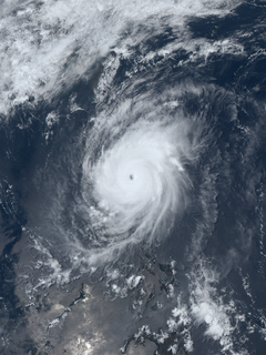
WHurricane Joaquin was a powerful tropical cyclone that devastated several districts of the Bahamas and caused damage in the Turks and Caicos Islands, parts of the Greater Antilles, and Bermuda. It was also the strongest Atlantic hurricane of non-tropical origin recorded in the satellite era. The tenth named storm, third hurricane, and second major hurricane of the 2015 Atlantic hurricane season, Joaquin evolved from a non-tropical low to become a tropical depression on September 28, well southwest of Bermuda. Tempered by unfavorable wind shear, the depression drifted southwestward. After becoming a tropical storm the next day, Joaquin underwent rapid intensification, reaching hurricane status on September 30 and Category 4 major hurricane strength on October 1. Meandering over the southern Bahamas, Joaquin's eye passed near or over several islands. On October 3, the hurricane weakened somewhat and accelerated to the northeast. Abrupt re-intensification ensued later that day, and Joaquin acquired sustained winds of 155 mph (250 km/h), just short of Category 5 strength.
 W
WHurricane Kate was the latest Atlantic hurricane to form in the Atlantic basin since Epsilon in 2005, as well as one of the northernmost November hurricanes on record. The eleventh and final named storm and hurricane of the 2015 Atlantic hurricane season, Kate formed out of a disorganized tropical wave that had moved off the coast of Africa on October 30. Unfavorable conditions prevented it from significantly organizing as it traversed the Atlantic. Once it neared the northern coast of Hispaniola on November 7, it began to become somewhat better organized. The next day it developed into a tropical depression; shortly afterwards it developed into Tropical Storm Kate. Kate moved northwest around an area of high pressure, gradually strengthening. On November 11, it intensified into a hurricane while simultaneously peaking in intensity. Shortly afterwards, it transitioned into an extratropical cyclone.
 W
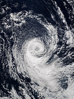
WSubtropical Cyclone Katie, unofficially named by researchers, was an unusual weather event in early 2015. After the 2014–15 South Pacific cyclone season had officially ended, a rare subtropical cyclone was identified outside of the basin near Easter Island, during early May, and was unofficially dubbed Katie by researchers. Katie was one of the few tropical or subtropical systems ever observed forming in the far Southeast Pacific, outside of the official basin boundary of 120°W, which marks the eastern edge of RSMC Nadi's and RSMC Wellington's warning areas, during the satellite era. Due to the fact that this storm developed outside of the official areas of responsibility of the warning agencies in the South Pacific, the storm was not officially included as a part of the 2014–15 South Pacific cyclone season. However, the Chilean Navy Weather Service issued High Seas Warnings on the system as an extratropical low.
 W
WCyclonic Storm Komen was an unusual tropical cyclone that originated near the southern coast of Bangladesh and later struck the same country while drifting over the northern Bay of Bengal. The second named storm of the 2015 season, Komen brought several days of heavy rainfall to Myanmar, Bangladesh, and India. It formed as a depression on July 26 over the Ganges delta and moved in a circular motion around the northern Bay of Bengal. Komen intensified into a 75 km/h (45 mph) cyclonic storm and moved ashore southeastern Bangladesh on July 30. The system turned westward over land and was last noted over eastern India on August 2.
 W
WTyphoon Koppu, known in the Philippines as Typhoon Lando, was a powerful and devastating tropical cyclone that struck Luzon in October 2015. It was the twenty-fourth named storm and the fifteenth typhoon of the annual typhoon season. Similar to Goni earlier in the year, Koppu originated from a tropical disturbance east of the Mariana Islands on October 10. Moving briskly west, the system consolidated into a tropical depression the following day and further into a tropical storm on October 13. Situated over the warm waters of the Philippine Sea, Koppu quickly deepened. The storm reached its peak intensity on October 17 with ten-minute sustained winds of 185 km/h (115 mph) according to the Japan Meteorological Agency (JMA). The Joint Typhoon Warning Center assessed Koppu to have been a Category 4-equivalent super typhoon with one-minute sustained winds of 240 km/h (150 mph). The storm subsequently made landfall at this strength near Casiguran, Philippines. Rapid weakening ensued due to interaction with the mountainous terrain of Luzon and the disheveled core of Koppu emerged over the West Philippine Sea on October 19. Unfavorable environmental conditions inhibited reorganization and the system diminished to a tropical depression on October 21.
 W
WCyclone Lam was the strongest storm to strike Australia's Northern Territory since Cyclone Monica in 2006. It formed from the monsoon trough on February 12 in the Coral Sea. For much of its duration, the system moved westward due to a ridge to the south. The system crossed over the Cape York Peninsula and moved into the Gulf of Carpentaria, whereupon it gradually organized due to warm waters and favorable outflow. On February 16, the Bureau of Meteorology (BoM) classified it as a Category 1 on the Australian tropical cyclone intensity scale and gave it the name Lam. The storm intensified further while drifting toward the Wessel Islands, developing an eye and strengthening to the equivalence of a minimal hurricane on February 18. It strengthened to reach maximum sustained winds of 185 km/h (115 mph) early on February 19 before turning to the southwest, making it a Category 4 cyclone. That day, it made landfall on Northern Territory between Milingimbi and Elcho Island at peak intensity, and it rapidly weakened over land. About six hours after Lam moved ashore, Cyclone Marcia struck Queensland as a Category 5 cyclone, marking the first time on record that two storms of Category 4 intensity struck Australia on the same day.
 W
WHurricane Linda was a strong tropical cyclone in September 2015 that resulted in heavy rains across portions of Mexico and the Southwestern United States. The seventeenth named storm, eleventh hurricane, and eighth major hurricane of the season, Linda developed southwest of Mexico from a low pressure area on September 5. Under warm sea surface temperatures and low to moderate wind shear, the system intensified into Tropical Storm Linda by September 6 and a hurricane by the next day. A well-defined eye soon formed within the storm's central dense overcast and Linda reached its peak intensity as a 125 mph (205 km/h) Category 3 major hurricane on the Saffir–Simpson hurricane wind scale on September 8. Thereafter, the storm moved into a stable environment and an area of lower sea surface temperatures, causing rapid weakening. Convective activity dissipated and Linda degenerated into a remnant low on September 10. The lingering system persisted southwest of Baja California, ultimately opening up into a trough on September 14.
 W
WSevere Tropical Storm Linfa, known in the Philippines as Severe Tropical Storm Egay, was a tropical cyclone that affected the northern Philippines, Taiwan and southern China in early July 2015. The tenth named storm of the annual typhoon season, Linfa developed on July 1 over in the Philippine Sea. It moved erratically westward toward the Philippines, eventually striking the island of Luzon on July 4. Linfa weakened across the island, but reorganized over the South China Sea. It turned northward and strengthened to near typhoon intensity, or winds of 120 km/h (75 mph), but weakened as it curved to the northwest toward southern China. On July 9, the storm made landfall along the Chinese province of Guangdong, dissipating the next day west of Hong Kong.
 W
WSevere Tropical Cyclone Marcia was a powerful tropical cyclone that made landfall at its peak strength over central Queensland, near Shoalwater Bay on 20 February 2015. The cyclone went on to affect various areas including Yeppoon and Rockhampton. It passed just to the west of Yeppoon as a Category 4 system, then traversed over the regional city of Rockhampton as a Category 2 system on the same day. Eventually, the cyclone weakened, moved southeast out to sea, before dissipating. Marcia caused at least A$750 million (US$587 million) worth of damage.
 W
WHurricane Marty was a tropical cyclone that produced heavy rains and flooding in several states in Southwestern and Western Mexico. The twentieth named storm and twelfth hurricane of the annual hurricane season, Marty developed from a tropical wave on September 26, 2015 to the southwest of Acapulco, Guerrero, in Mexico. Initially a tropical depression, the system strengthened into a tropical storm early on the following day. Due to favorable atmospheric conditions, Marty continued to intensify, but wind shear sharply increased as the storm approached a large mid- to upper-level trough. Despite this, the cyclone deepened further, becoming a hurricane on September 28 and peaking with sustained winds of 80 mph (130 km/h) shortly thereafter. Wind shear quickly took its toll on the hurricane, weakening it to a tropical storm early on September 29. About 24 hours later, Marty degenerated into a post-tropical low pressure area offshore Guerrero. The low further degenerated into a trough later on September 30, and eventually dissipated on October 4.
 W
WTyphoon Maysak, known in the Philippines as Typhoon Chedeng, was the most powerful pre-April tropical cyclone on record in the Northwestern Pacific Ocean. The fourth named storm of the 2015 Pacific typhoon season, Maysak originated as a tropical depression on March 26. The next day, the Japan Meteorological Agency (JMA) upgraded the depression to a tropical storm and assigned it the name Maysak. According to the JMA, Maysak became the second typhoon of the year on March 28. The typhoon explosively intensified into a Category 5 super typhoon on March 31, passing near the islands of Chuuk and Yap in the Federated States of Micronesia. After maintaining that intensity for 18 hours, Maysak weakened, made landfall over the Philippine island of Luzon as a minimal tropical storm, and dissipated shortly afterwards.
 W
WExtremely Severe Cyclonic Storm Megh is regarded as the worst tropical cyclone to ever strike the Yemeni island of Socotra, causing additional destruction there after Cyclone Chapala hit the same island. Megh formed on November 5, 2015, in the eastern Arabian Sea, and followed a path similar to Chapala. After moving northward, the cyclone turned to the west, and fueled by warm water temperatures, it quickly intensified. On November 7, the storm developed an eye in the center and began to rapidly intensify into a mature cyclone. By the next day, the India Meteorological Department estimated peak 3 minute sustained winds of 175 km/h (110 mph), and the American-based Joint Typhoon Warning Center estimated 1 minute winds of 205 km/h (125 mph). Shortly thereafter, the cyclone brushed the northern coast of Socotra. The storm steadily weakened thereafter, especially after it skirted the northern Somalia coast. After entering the Gulf of Aden, Megh turned to the west-northwest and struck southwestern Yemen on 10 November as a deep depression, dissipating shortly thereafter.
 W
WSevere Tropical Storm Mekkhala, known in the Philippines as Tropical Storm Amang, was an early-season tropical cyclone that made landfall over the Philippines in January 2015. Mekkhala killed three people in the Bicol Region and caused light crop damage. Notably, the storm disturbed Pope Francis’ visit to the country after the victims of Typhoon Haiyan on November 8, 2013. Although the storm also caused an airplane crash in Tacloban, nobody was hurt in the incident.
 W
WTyphoon Melor, known in the Philippines as Typhoon Nona, was a powerful tropical cyclone that struck the Philippines in December 2015. The twenty-seventh named storm and the eighteenth typhoon of the annual typhoon season, Melor killed 51 people and caused ₱7.04 billion in damage.
 W
WTyphoon Mujigae, known in the Philippines as Tropical Storm Kabayan, was the strongest storm to strike the province of Guangdong in the month of October. The storm affected the Philippines, southern China and northern Vietnam during early October 2015 as a strong typhoon. The typhoon originated from a weak tropical disturbance near Palau on September 28. The system subsequently developed into the twenty-second named storm of the annual typhoon season on October 1.
 W
WTyphoon Nangka was a large and powerful tropical cyclone that impacted central Japan in mid-July 2015. Nangka started its long-living journey as a tropical disturbance over the Marshall Islands and west of the International Dateline, becoming the eleventh named storm of the annual typhoon season on July 3. It quickly intensified while moving to the west-northwest, attaining typhoon status on July 6. Nangka moved through the Northern Marianas Islands, passing directly over the uninhabited island of Alamagan. Shortly thereafter, the typhoon attained peak winds; the Japan Meteorological Agency (JMA) estimated 10‑minute sustained winds of 185 km/h (115 mph), while the unofficial Joint Typhoon Warning Center (JTWC) estimated 1‑minute winds of 250 km/h (155 mph), making it a super typhoon. Nangka later weakened as it curved to the north, moving across central Japan on July 16 as a minimal typhoon. The storm weakened soon after, dissipating in the Sea of Japan on July 18.
 W
WTyphoon Noul, known in the Philippines as Typhoon Dodong, was a relatively small but powerful tropical cyclone that affected several areas but caused minor damage. The sixth named storm and third typhoon of the annual typhoon season, Noul formed as a tropical depression over the eastern Caroline Islands on May 2, 2015. It moved generally to the west and west-northwest, gradually intensifying into a tropical storm and later typhoon. On May 9, Noul began rapid deepening as it developed a well-defined eye. Early the next day, the Japan Meteorological Agency (JMA) estimated peak 10 minute sustained winds of 205 km/h (125 mph), while the American-based Joint Typhoon Warning Center (JTWC) estimated peak 1 minute winds of 260 km/h (160 mph), equivalent to Category 5 on the Saffir–Simpson hurricane wind scale. Noul struck northeastern Luzon in the Philippines at that intensity and greatly weakened. After passing east of Taiwan, the typhoon accelerated to the northeast and weakened due to unfavorable conditions. On May 12, Noul became extratropical south of Japan, and the remnants continued to the northeast for several days, dissipating on May 16.
 W
WSevere Tropical Cyclone Pam was tied with Cyclone Yasa in 2020 as the second most intense tropical cyclone of the south Pacific Ocean in terms of sustained winds and is regarded as one of the worst natural disasters in the history of Vanuatu. A total of 15–16 people lost their lives either directly or indirectly as a result of Pam with many others injured. The storm's impacts were also felt, albeit to a lesser extent, to other islands in the South Pacific, most notably the Solomon Islands, Tuvalu, and New Zealand. Pam is the third most intense storm of the South Pacific Ocean according to pressure, after Winston of 2016 and Zoe of 2002. It is also the second most intense tropical cyclone in 2015, only behind Hurricane Patricia. In addition, Pam is tied with Orson, Monica, Marcus, Fantala and Yasa for having the second strongest ten-minute maximum sustained winds in the Southern Hemisphere. Thousands of homes, schools and buildings were damaged or destroyed, with an estimated 3,300 people displaced as a result.
 W
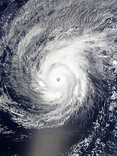
WHurricane Patricia was an exceptionally powerful tropical cyclone that became the strongest on record worldwide in terms of wind speed and the second-most intense on record worldwide in terms of pressure, behind Typhoon Tip in 1979, with a minimum atmospheric pressure of 872 mbar. Originating from a sprawling disturbance near the Gulf of Tehuantepec, south of Mexico, in mid-October 2015, Patricia was first classified a tropical depression on October 20. Initial development was slow, with only modest strengthening within the first day of its classification. The system later became a tropical storm and was named Patricia, the twenty-fourth named storm of the annual hurricane season. Exceptionally favorable environmental conditions fueled explosive intensification on October 22. A well-defined eye developed within an intense central dense overcast and Patricia grew from a tropical storm to a Category 5 hurricane in just 24 hours—a near-record pace. On October 23, the hurricane achieved its record peak intensity with maximum sustained winds of 215 mph (345 km/h). This made it the most intense tropical cyclone on record in the Western Hemisphere and the strongest globally in terms of one-minute maximum sustained winds.
 W
WHurricane Patricia was the most intense tropical cyclone ever recorded in the Western Hemisphere and the second-most intense worldwide in terms of barometric pressure. It also featured the highest one-minute maximum sustained winds ever recorded in a tropical cyclone. Originating from a sprawling disturbance near the Gulf of Tehuantepec in mid-October 2015, Patricia was first classified a tropical depression on October 20. Initial development was slow, with only modest strengthening within the first day of its classification. The system later became a tropical storm and was named Patricia, the twenty-fourth named storm of the annual hurricane season. Exceptionally favorable environmental conditions fueled explosive intensification on October 22. A well-defined eye developed within an intense central dense overcast and Patricia grew from a tropical storm to a Category 5 hurricane in just 24 hours—a near-record pace. The magnitude of intensification was poorly forecast and both forecast models and meteorologists suffered from record-high prediction errors.
 W
WTropical Cyclone Raquel was the first tropical cyclone to exist within the South Pacific Ocean during the month of July on record. The system was first noted during June 28, 2015, while it was located to the northeast of Honiara in the Solomon Islands within the South Pacific basin. Over the next few days the system moved south-westwards towards the Solomon Islands, under the influence of a ridge of high pressure and gradually developed further. The system was subsequently named Raquel during June 30, as it moved into the Australian region and developed into a Category 1 tropical cyclone on the Australian tropical cyclone intensity scale. Strong vertical wind shear subsequently limited further development of the system, with atmospheric convection surrounding the system displaced to the west and south of the system. The system subsequently weakened into a tropical depression during July 2, after it had recurved and move eastwards into the South Pacific basin. During that day atmospheric convection surrounding the system improved, as it started to move towards the south-southwest and the Australian region. Raquel subsequently passed near or over several of the Solomon Islands between July 3–5, before it was last noted to the south-west of Guadalcanal during July 5, as it rapidly lost its tropical characteristics.
 W
WHurricane Sandra was the latest-forming major hurricane in the northeastern Pacific basin, the strongest November Pacific hurricane on record, and the record eleventh major hurricane of the 2015 Pacific hurricane season. Originating from a tropical wave, Sandra was first classified as a tropical depression on November 23 well south of Mexico. Environmental conditions, including high sea surface temperatures and low wind shear, were highly conducive to intensification and the storm quickly organized. A small central dense overcast developed atop the storm and Sandra reached hurricane status early on November 25 after the consolidation of an eye. Sandra reached its peak intensity as a Category 4 hurricane on the Saffir–Simpson hurricane wind scale with winds of 150 mph (240 km/h) and a pressure of 934 mbar early on November 26. Thereafter, increasing shear degraded the hurricane's structure and weakening ensued. Rapid weakening took place on November 27 and Sandra's circulation became devoid of convection as it diminished to a tropical storm that evening. The cyclone degenerated into a remnant low soon thereafter and ultimately dissipated just off the coast of Sinaloa, Mexico, on November 29.
 W
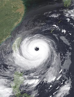
WTyphoon Soudelor, known in the Philippines as Typhoon Hanna, was the third most intense tropical cyclone worldwide in 2015 after Hurricane Patricia and Cyclone Pam as well as the strongest tropical cyclone of the 2015 Pacific typhoon season. Soudelor had severe impacts in the Northern Mariana Islands, Taiwan, and eastern China, resulting in 40 confirmed fatalities. Lesser effects were felt in Japan, South Korea and the Philippines. The thirteenth named storm of the annual typhoon season, Soudelor formed as a tropical depression near Pohnpei on July 29. The system strengthened slowly at first before entering a period of rapid intensification on August 2. Soudelor made landfall on Saipan later that day, causing extensive damage. Owing to favorable environmental conditions, the typhoon further deepened and reached its peak intensity with ten-minute maximum sustained winds of 215 km/h (130 mph) and a central atmospheric pressure of 900 hPa on August 3. The Joint Typhoon Warning Center assessed one-minute sustained winds at 285 km/h (180 mph), making Soudelor a Category 5-equivalent super typhoon. Steady weakening ensued thereafter as the storm moved generally west-northwest. Soudelor made landfall over Hualien, Taiwan, late on August 7 and emerged over in the Taiwan Strait early the next day. The typhoon soon moved inland over eastern China and degraded to a tropical depression by August 9.
 W
WSevere Tropical Cyclone Ula was a powerful and long-lived tropical cyclone during late December 2015 and mid-January 2016. It originated from a tropical disturbance on December 26, 2015, east of the Solomon Islands. Moving generally east, development was initially slow and the system finally reached cyclone strength—having gale-force winds—on December 30. The newly christened Tropical Cyclone Ula turned sharply south and rapidly intensified, attaining hurricane-strength the following day. A shift to the southwest brought the system close to the northern islands of Tonga on January 2, 2016. It subsequently brushed several islands in the Lau Group of Fiji before weakening. Nearly degrading to a tropical depression, Ula turned to the northwest and regained strength. After turning back to the southwest, it achieved its peak intensity as a Category 4 on the Australian scale with winds of 185 km/h (115 mph) on January 10. Thereafter, the storm bypassed Vanuatu to the southeast and New Caledonia to the east as it accelerated southward.
 W
WTropical Storm Vamco was a weak tropical cyclone which affected Indochina in mid-September 2015. Formed from a tropical disturbance on September 13, the system developed into a tropical storm and reached its peak intensity on September 14. Vamco made landfall in Vietnam and affected Laos, Thailand and Cambodia. The storm caused flooding in these countries and damages amounted to US$14.1 million. Fifteen people died in the floods.
 W
WTyphoon Dujuan, known in the Philippines as Typhoon Jenny, was the second most intense tropical cyclone of the Northwest Pacific Ocean in 2015 in terms of ten-minute maximum sustained winds, tied with Noul. The twenty-first named storm and the thirteenth typhoon of the 2015 Pacific typhoon season, Dujuan brought extremely powerful winds throughout the Yaeyama Islands and Taiwan in late September, causing 3 deaths in Taiwan. The typhoon also caused over ¥2.5 billion (US$392.9 million) damage in East China.