 W
WIn the south-west Indian Ocean, tropical cyclones form south of the equator and west of 90° E to the coast of Africa.
 W
WThe 1959–60 South-West Indian Ocean cyclone season featured the beginning of tropical cyclone naming in the basin.
 W
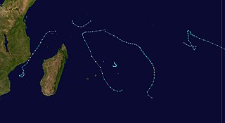
WThe 1960–61 South-West Indian Ocean cyclone season was one of the least active South-West Indian Ocean cyclone seasons on record. It only had 6 tropical depressions, 5 named storms, 4 tropical storms, and 1 cyclone, Doris. Additionally, none of its storms made landfall, therefore it had almost no deaths or damage. The season was also the second with named storms, the first being 1959–60.
 W
WThe 1961–62 South-West Indian Ocean cyclone season was a busy cyclone season, lasting from December to April.
 W
WThe 1962–63 South-West Indian Ocean cyclone season was an average cyclone season, although it began early with the first October storm since 1911. Two storms formed in December, both of them passing near the Mascarene Islands.
 W
WThe 1963–64 South-West Indian Ocean cyclone season was an average cyclone season.
 W
WThe 1964–65 South-West Indian Ocean cyclone season was an active cyclone season.
 W
WThe 1965–66 South-West Indian Ocean cyclone season was an average cyclone season.
 W
WThe 1966–67 South-West Indian Ocean cyclone season was an average cyclone season.
 W
WThe 1967–68 South-West Indian Ocean cyclone season was an above average cyclone season.
 W
WThe 1968–69 South-West Indian Ocean cyclone season was a below average cyclone season.
 W
WThe 1969–70 South-West Indian Ocean cyclone season was an active cyclone season.
 W
WThe 1970–71 South-West Indian Ocean cyclone season was an above-average cyclone season. The season officially ran from November 1, 1970, to April 30, 1971.
 W
WThe 1971–72 South-West Indian Ocean cyclone season was a below-average cyclone season. The season officially ran from November 1, 1971, to April 30, 1972.
 W
WThe 1974–75 South-West Indian Ocean cyclone season was a below-average cyclone season. The season officially ran from November 1, 1974, to April 30, 1975.
 W
WThe 1975–76 South-West Indian Ocean cyclone season was a below-average cyclone season. The season officially ran from November 1, 1975, to April 30, 1976.
 W
WThe 1976–77 South-West Indian Ocean cyclone season was a below-average cyclone season. The season officially ran from November 1, 1976, to April 30, 1977.
 W
WThe 1977–78 South-West Indian Ocean cyclone season was an above average cyclone season. The season officially ran from November 1, 1977, to April 30, 1978.
 W
WThe 1978–79 South-West Indian Ocean cyclone season was an average cyclone season. The season officially ran from November 1, 1978, to April 30, 1979.
 W
WThe 1979–80 South-West Indian Ocean cyclone season was an above-average cyclone season. The season officially ran from November 1, 1979, to April 30, 1980.
 W
WThe 1980–81 South-West Indian Ocean cyclone season was an average cyclone season.
 W
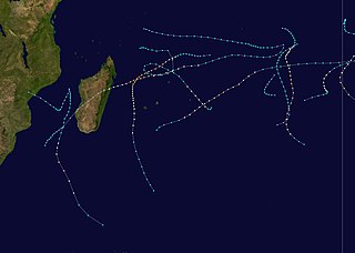
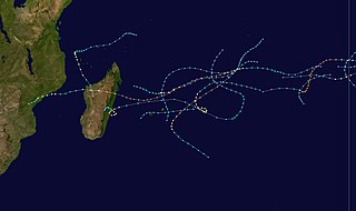
WThe 1981–82 South-West Indian Ocean cyclone season was destructive and deadly in Madagascar, where four cyclones killed 100 people and caused $250 million (USD) in damage. The season was fairly active, lasting from October to May. There were nine named storms that attained gale-force winds, or at least 65 km/h (40 mph). Five of the storms attained tropical cyclone status, which have 10 minute sustained winds of at least 120 km/h (75 mph).
 W
WThe 1982–83 South-West Indian Ocean cyclone season was least active cyclone season in the basin since 1961–1962. There were six systems that were named, although three of them – Arilisy, Clera, and Fely – failed to intensify beyond tropical depression status. No storms reached tropical cyclone status, according to the official warning agency for the basin, Météo-France, although the two strongest storms – Bemany and Elinah – peaked just below that intensity. The first named storm, Arilisy, formed on October 27, and dissipated without having affected land. However, the Joint Typhoon Warning Center (JTWC), which is an unofficial warning center for the basin, briefly tracked a tropical depression in July. The next storm was Bemany, which passed east of Mauritius near peak intensity in early December. Tropical Depression Clera existed briefly in the middle of September, and Tropical Storm Dadafy moved across the eastern portion of the basin in late December.
 W
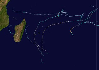
WThe 1983–84 South-West Indian Ocean cyclone season featured above normal activity and several deadly storms. There was steady storm activity from December through April due to favorable conditions, such as warm sea surface temperatures and an active monsoon. The first named storm – Andry – was tied for the strongest with Bakoly, Jaminy, and Kamisy. Cyclone Andry passed near Agaléga island within Mauritius, damaging or destroying every building there and killing one person. It later struck Madagascar, the first of three storms to strike the nation within two months, which collectively caused $25 million in damage and 42 deaths. The third of these storms, Tropical Storm Domoina, caused deadly flooding in southeastern Africa that killed 242 people and caused $199 million in damage. The storm destroyed more than 50 small dams in Madagascar and caused the worst flooding in Swaziland in 20 years. In addition three of the first storms affecting Madagascar, Cyclone Bakoly in December left $21 million in damage on Mauritius.
 W
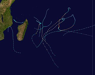
WThe 1984–85 South-West Indian Ocean cyclone season was an average cyclone season. Tropical cyclones in this basin are monitored by the Regional Specialised Meteorological Centre in Réunion. The first storm formed in mid-November, though it was not officially named. A few days later, the first official storm of the year (Anety) formed. In December, one storm formed. During January 1985, two tropical cyclones formed towards the end of the month. Three more systems developed in a short period of time in early to mid-February. After nearly two more months of inactivity, an unusually powerful late season storm developed (Helisaonina) in mid-April, which was the strongest storm of the year. While a number of storms during the season reached severe tropical storm status, only one of those intensified further. Even though two tropical cyclones this year made landfall, no known damage was recorded.
 W
WThe 1985–86 South-West Indian Ocean cyclone season was the first in which the Météo-France office (MFR) on Réunion tracked cyclones as far east as 90° E in Indian Ocean, south of the equator. Previously, the agency's area of responsibility was limited to 80° E. It was an active season with twelve named storms, of which five strengthened into tropical cyclone with 10 minute sustained winds of at least 120 km/h (75 mph). The first named storm was Tropical Storm Alifredy, which originated in the Mozambique Channel in late December and moved across Madagascar. However, the unofficial Joint Typhoon Warning Center (JTWC) tracked a short-lived storm in September.
 W
WThe 1986–87 South-West Indian Ocean cyclone season was below average due to an ongoing El Niño and a weak monsoon that suppressed convection and storms. There were only five named storms tracked by the Météo-France office (MFR) on Réunion. The United States-based Joint Typhoon Warning Center (JTWC) followed four other storms in the basin, which is the waters of the Indian Ocean south of the equator and west of 90° E to the coast of Africa. The JTWC tracked a storm on August 1 in the northeastern portion of the basin, unusual for the time of year. The first named storm was Severe Tropical Storm Alinina, which originated from the intertropical convergence zone east of Madagascar in the middle of January. However, there was an unnamed tropical depression that produced heavy rainfall in Réunion and Madagascar, causing two deaths in the latter country.
 W
WThe 1987–88 South-West Indian Ocean cyclone season was a moderately active cyclone season, with nine named storms. Four of the storms attained tropical cyclone status, which is the equivalent of a minimal hurricane with 10 minute sustained winds of at least 120 km/h (75 mph). The seasonal activity was evenly dispersed, officially beginning on December 9 when the Météo-France office (MFR) on Réunion started tracking Tropical Storm Ariny. The storm crossed 90° E from the adjacent Australian basin, one of two storms in the season to do so along with Cyclone Ezenina. There were also two storms tracked unofficially by the Joint Typhoon Warning Center (JTWC) in November.
 W
WThe 1988–89 South-West Indian Ocean cyclone season was an active season that featured several storms moving near or over the Mascarene Islands or Madagascar. The eleven tropical storms was two greater than average, of which five became tropical cyclones – a storm with maximum sustained winds over 10 minutes of 120 km/h (75 mph) or greater. Storms were monitored by the Météo-France office (MFR) on Réunion island in an official capacity, as well as the American Joint Typhoon Warning Center (JTWC) on an unofficial base. The season began early with Moderate Tropical Storm Adelinina forming in early November, and continued through the middle of April. Adelinina was one of two storms to form in November, the other being Tropical Cyclone Barisaona which crossed from the adjacent Australian basin.
 W
WThe 1989–90 South-West Indian Ocean cyclone season was an average cyclone season, with nine named storms and five tropical cyclones – a storm attaining maximum sustained winds of at least 120 km/h (75 mph). The season officially ran from November 1, 1989, to April 30, 1990. Storms were officially tracked by the Météo-France office (MFR) on Réunion while the Joint Typhoon Warning Center (JTWC) in an unofficial basis. The first storm, Cyclone Alibera, was the second longest-lasting tropical cyclone on record in the basin, with a duration of 22 days. Alibera meandered and changed directions several times before striking southeastern Madagascar on January 1, 1989, where it was considered the worst storm since 1925. The cyclone killed 46 people and left widespread damage. Only the final storm of the year – Severe Tropical Storm Ikonjo – also had significant impact on land, when it left $1.5 million in damage (1990 USD) in the Seychelles.
 W
WThe 1990–91 South-West Indian Ocean cyclone season was fairly quiet, although activity began early and the final named storm formed at a record late date. There were seven named storms classified by the Météo-France office (MFR) on Réunion, as well as three depressions; an additional depression was classified by the Joint Typhoon Warning Center (JTWC), an unofficial warning agency. The JTWC tracked storms in both September and October, although neither affected land. In late November, another short-lived depression formed in the northeastern portion of the basin. Activity remained minimal until January, when Tropical Storm Alison formed in the eastern portion of the basin. Later in the month, Cyclone Bella became the strongest storm of the season, reaching 10‑minute maximum sustained winds of 155 km/h (100 mph). It passed near the island of Rodrigues, becoming the worst cyclone there in 20 years and killing half of the population of one endangered species. Bella also likely caused a cargo ship to go missing with 36 people on board.
 W
WThe 1991–92 South-West Indian Ocean cyclone season was an average cyclone season in which most storms remained over open waters. At the time, the season lasted from November 15, 1991, to April 30, 1992, although this season began early when three tropical depressions formed before the official start. The second, designated Tropical Depression A2 by the Météo-France office (MFR) on Réunion, passed north of Madagascar on October 16 before weakening.
 W
WThe 1992–93 South-West Indian Ocean cyclone season lasted longer than normal, with the first storm Aviona forming on September 27 and the final storm Konita not dissipating until May 7. It was an above-average season, with four tropical cyclones – the equivalent of a minimal hurricane – along with six tropical storms, one subtropical depression, and several depressions including one that was named. The basin is defined as the area west of 90°E and south of the Equator in the Indian Ocean, which includes the waters around Madagascar westward to the east coast of Africa. Tropical cyclones in this basin are monitored by the Regional Specialised Meteorological Centre in Réunion (MFR), as well as by the Joint Typhoon Warning Center (JTWC).
 W
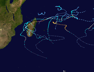
WThe 1993–94 South-West Indian Ocean cyclone season was the most active since the start of reliable satellite coverage in 1967, until it was surpassed by the 2018–19 South-West Indian Ocean cyclone season, 25 years later. Activity lasted from mid-November, when Moderate Tropical Storm Alexina formed, until mid-April, when Tropical Cyclone Odille became extratropical. Four tropical cyclones – Daisy, Geralda, Litanne, and Nadia – struck eastern Madagascar, of which Geralda was the costliest and deadliest. With gusts as strong as 350 km/h (220 mph) accompanied by heavy rainfall, Geralda destroyed more than 40,000 homes and left 356,000 people homeless. Geralda killed 231 people and caused more than $10 million in damage. Cyclone Nadia was the second deadliest cyclone, having killed 12 people in northern Madagascar and later severely damaging portions of northeastern Mozambique, killing about 240 people and leaving $20 million in damage in the latter country. In February, Cyclone Hollanda struck Mauritius near peak intensity, causing $135 million in damage and two deaths.
 W
WThe 1994–95 South-West Indian Ocean cyclone season was fairly active, with storms forming regularly from October through April. It was much less damaging than its predecessor, and most of the storms in the season remained over water or only brushed land. The first system was Tropical Depression A1, which formed in October and passed north of Madagascar. The first named storm was Albertine, which formed on November 23 in the northeastern portion of the basin and became one of three intense tropical cyclones. The last storm was Marlene, which was also an intense tropical cyclone and dissipated on April 11.
 W
WThe 1995–96 South-West Indian Ocean cyclone season was a moderately active season that included Cyclone Bonita, which was the first known tropical cyclone to cross from the southern Indian Ocean into the southern Atlantic Ocean. Tropical activity lasted for about six months from the middle of November 1995 to early May 1996. The first storm, Intense Tropical Cyclone Agnielle, formed in the adjacent Australian basin on November 16 and later reached peak winds in the south-west Indian Ocean. The next named storm after Agnielle was Bonita, which formed in early January and killed 42 people. The basin was most active in February, with two tropical cyclones, or the equivalent of a minimal hurricane, as well as a severe tropical storm. The first of these three was Doloresse, which killed 67 people due to a shipwreck in the Comoros. The next storm was Cyclone Edwige, which caused heavy crop damage on Mauritius before looping along the east coast of Madagascar. In March, both Cyclone Flossy and Tropical Storm Guylianne passed near the Mascarene Islands, producing heavy rainfall and gusty winds.
 W
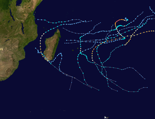
WThe 1996–97 South-West Indian Ocean cyclone season was the longest on record, with both an unusually early start and unusually late ending. Most activity was from November through February. According to the Météo-France office (MFR) at Réunion, there were 21 tropical disturbances, 14 of which intensified into tropical depressions. There were 12 named storms, beginning with Antoinette and proceeding sequentially until Lisette. In addition, the Joint Typhoon Warning Center also warned on storms in the region, which identified five other tropical storms. Five of the storms attained tropical cyclone status, or with 10–minute maximum sustained winds of at least 120 km/h (75 mph); of these, three strengthened further into intense tropical cyclones, with Daniella and Helinda tied for strongest storm of the season.
 W
WThe 1997–98 South-West Indian Ocean cyclone season was fairly quiet and had the latest start in 30 years. The first tropical disturbance originated on January 16, although the first named storm, Anacelle, was not upgraded until February 8, a record late start. The last storm to dissipate was an unusually late tropical depression in late July. Many of the storms suffered from the effects of wind shear, which contributed to there being only one tropical cyclone – equivalent to a minimal hurricane. The season also occurred during a powerful El Niño.
 W
WThe 1998–99 South-West Indian Ocean cyclone season was a quiet season that had the fourth-lowest number of days with tropical storm or tropical cyclone activity. Most of the storms formed either in the Mozambique Channel or in the far eastern portion of the basin, with five storms crossing from the adjacent Australian basin east of 90° E. As a result, few storms impacted Madagascar, and none made landfall on the African continent. Throughout most of the season, there was below-normal sea surface temperatures in the Indian Ocean east of Madagascar. In February, typically the peak in activity, Réunion island recorded its highest average monthly pressure since 1953. Due to generally unfavorable conditions, there were only six tropical storms tracked by the Météo-France office (MFR) on Réunion. There were only two tropical cyclones – a storm with winds of at least 120 km/h (75 mph).
 W
WThe 1999–2000 South-West Indian Ocean tropical cyclone season was the first on record in which two storms – Leon–Eline and Hudah – struck Mozambique at tropical cyclone intensity, or with maximum sustained winds of at least 120 km/h (75 mph). The most notable storm of the season was Eline, which was the third longest-lasting storm on record in the basin. It lasted for 29 days while traversing the southern Indian Ocean, making the strongest landfall in decades along eastern Madagascar in late February. The storm was the first in a series of three storms that struck the country in early 2000, along with Gloria in March and Hudah in April. Collectively, the three storms killed at least 316 people. The season started on November 1, 1999, and ended for most of the basin on April 30, 2000; for Mauritius and the Seychelles, the season continued until May 15. These dates conventionally delimit the period of each year when most tropical cyclones form in the basin;
 W
WThe 2000–01 South-West Indian Ocean cyclone season was a fairly quiet season with only five named storms, although there was an additional unnamed tropical storm and two subtropical cyclones with gale-force winds. It started early, with a tropical disturbance forming on August 1 – the first day of the cyclone year. However, the first named storm, Ando, was not named until January 2, which at the time was the 4th latest on record. Ando would become the most intense cyclone of the year, reaching peak winds of 195 km/h (120 mph) according to the Météo-France office (MFR) on Réunion, the official Regional Specialized Meteorological Center for the basin. The agency tracked storms south of the Equator and west of 90°E to the east coast of Africa.
 W
WThe 2001–02 South-West Indian Ocean cyclone season had the earliest named storm since 1992. Many storms formed in the north-east portion of the basin, and several more originated around Australia. The basin is defined as the waters of the Indian Ocean west of longitude 90°E to the coast of Africa and south of the equator. Eleven tropical storms formed, compared to an average of nine. Tropical systems were present during 73 days, which was significantly higher than the average of 58 for this basin.
 W
WThe 2002–03 South-West Indian Ocean cyclone season was one of the longest lasting and the third-most active season in the South-West Indian Ocean. Storms during the season impacted the Mascarene Islands, Seychelles, Madagascar, and countries in southeastern Africa. The season began early when an unnamed tropical storm struck Seychelles in September, becoming the most damaging storm there in 50 years. The next system, Atang, was the first named storm of the season, but was only a tropical depression; it was named due to the threat to an outer island of Mauritius. Atang later struck Tanzania in a climatologically unusual area in November, resulting in unconfirmed deaths of fishermen. The first named storm to reach tropical storm intensity was Boura, which brushed the Mascarene Islands with gusty winds and rainfall. In December, Cyclone Crystal threatened to strike Mauritius but instead veered eastward, and later, Tropical Storm Delfina lasted from late December through early January 2003. Delfina damaged or destroyed thousands of houses in Mozambique and Malawi, killing 54 people.
 W
WThe 2003–04 South-West Indian Ocean cyclone season featured the most intense tropical cyclone in the South-West Indian Ocean, Cyclone Gafilo, as well as nine other named storms. Tropical activity began on September 28 when Moderate Tropical Storm Abaimba formed at a low latitude. Activity continued until late May, following Severe Tropical Storm Juba, which marked the third year in a row that a storm formed in May. The final disturbance, one of sixteen, dissipated on May 24. Activity was near average, and the season was one of the longest on record.
 W
WThe 2004–05 South-West Indian Ocean cyclone season was a near average season, despite beginning unusually early on August 30 with the formation of an early-season tropical depression. Météo-France's meteorological office in Réunion (MFR) ultimately monitored 18 tropical disturbances during the season, of which 15 became tropical depressions. Two storms – Arola and Bento – formed in November, and the latter became the most intense November cyclone on record. Bento attained its peak intensity at a low latitude, and weakened before threatening land. Tropical Cyclone Chambo was the only named storm in December. In January, Severe Tropical Storm Daren and Cyclone Ernest existed simultaneously. The latter storm struck southern Madagascar, and five days later, Moderate Tropical Storm Felapi affected the same area; the two storms killed 78 people and left over 32,000 people homeless. At the end of January, Severe Tropical Storm Gerard existed as an unnamed tropical storm for 18 hours due to discrepancies between warning centers.
 W
WThe 2005–06 South-West Indian Ocean cyclone season was the fifth least-active on record. The Météo-France office on the island of Réunion tracked 13 tropical disturbances, of which six intensified into a moderate tropical storm. Three of these systems proceeded to attain tropical cyclone status – reaching 10 minute maximum sustained winds of at least 120 km/h (75 mph). The American-based Joint Typhoon Warning Center also tracked eight storms in the basin. Activity was below normal due to a powerful Walker circulation, which increased convection over the neighboring Australian basin, but suppressed activity in the western Indian Ocean. As a result, most of the storms developed near or entered from the Australian basin, crossing 90°E to enter the South-West Indian Ocean.
 W
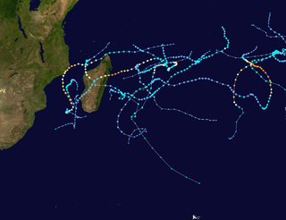
WThe 2006–07 South-West Indian Ocean cyclone season featured the second-most intense tropical cyclones for a season in the tropical cyclone basin, only behind the 2018–19 season. The basin contains the waters of the Indian Ocean south of the equator and west of 90°E. Météo-France's meteorological office in Réunion (MFR), the official Regional Specialized Meteorological Center for the South-West Indian Ocean, tracked 15 tropical disturbances, of which eleven attained gale-force winds. The season began in October 2006 with a short-lived tropical disturbance, followed by Anita in November, which was the first named storm of the season. Cyclone Bondo was the first of six intense tropical cyclones, which took a rare track through the southern Seychelles before making landfall on northwest Madagascar, killing 11 people. Severe Tropical Storm Clovis lasted from December 2006 to January 2007; it struck eastern Madagascar, killing four people.
 W
WThe 2007–08 South-West Indian Ocean cyclone season was the third most active tropical cyclone season, along with the 1985–86 season and behind the 1993–94 season and the 2018–19 season, with twelve named tropical cyclones developing in the region. It began on November 15, 2007, and ended on April 30, 2008, with the exception for Mauritius and the Seychelles, which ended May 15. These dates conventionally delimit the period of each year when most tropical cyclones form in the basin, which is west of 90°E and south of the Equator. Tropical cyclones in this basin are monitored by the Regional Specialised Meteorological Centre in Réunion.
 W
WThe 2008–09 South-West Indian Ocean cyclone season was a slightly above average event in tropical cyclone formation. It began on November 15, 2008, and officially ended on April 30, 2009, with the exception for Mauritius and the Seychelles, for which it ended on May 15, 2009. These dates conventionally delimit the period of each year when most tropical cyclones form in the basin, which is west of 90°E and south of the Equator. Tropical cyclones in this basin were monitored by the Regional Specialised Meteorological Centre in Réunion.
 W
WThe 2009–10 South-West Indian Ocean tropical cyclone season was a near average event in tropical cyclone formation. The season officially started on July 1, 2009, and ended on June 30, 2010, after incorporating the tropical cyclone season which ran from November 1 to April 30 for all areas except for Mauritius and the Seychelles, for which it ended on May 15, 2010. In this basin which officially runs from 30 to 90E, and is, to the south of the equator, the main warning center is the Regional Specialized Meteorological Center on La Reunion Island; however they delegate the naming of Cyclones to the Meteorological services of Mauritius and Madagascar.
 W
WThe 2010–11 South-West Indian Ocean cyclone season was the least active cyclone season on record in the basin, tied with 1982–83, producing only three systems of gale intensity. This was due to cooler than normal water temperatures and the Walker circulation – a broad atmospheric circulation – causing unusually moist conditions in the eastern Indian Ocean and unusually dry conditions in the western Indian Ocean. The basin includes the waters of the ocean south of the equator and west of 90º E to the eastern coast of Africa.
 W
WThe 2011–12 South-West Indian Ocean cyclone season was a slightly above average event in tropical cyclone formation. It began on November 15, 2011, and ended on April 30, 2012, with the exception for Mauritius and the Seychelles, for which it ended on May 15, 2012. These dates conventionally delimit the period of each year when most tropical cyclones form in the region; however, Severe Tropical Storm Kuena developed in early June after the season had officially ended. The basin is defined as the area west of 90°E and south of the Equator in the Indian Ocean, which includes the waters around Madagascar westward to the east coast of Africa. Tropical cyclones in this basin are monitored by the Regional Specialised Meteorological Centre in Réunion.
 W
WThe 2012–13 South-West Indian Ocean cyclone season was a slightly above average event in tropical cyclone formation in the Southern hemisphere tropical cyclone year starting on July 1, 2012, and ending on June 30, 2013. Within this basin, tropical and subtropical disturbances are officially monitored by the Regional Specialised Meteorological Centre on Réunion island, while the Mauritius and Madagascar weather services assign names to significant tropical and subtropical disturbances. The first tropical disturbance of the season developed on October 12 and rapidly developed into the earliest known intense tropical cyclone on record during October 14.
 W
WThe 2013–14 South-West Indian Ocean cyclone season was an above average event in tropical cyclone formation. The season officially began on July 1, 2013, though the first tropical system designated by Météo-France was a short-lived tropical disturbance that developed on July 8. However, the first named storm was Cyclone Amara in December. Bruce was the first very intense tropical cyclone since Edzani in 2010, which originated from the Australian region. The strongest system of the cyclone season was Hellen, also one of the most intense tropical cyclones over the Mozambique Channel. The season officially ended on June 30, 2014
 W
WThe 2014–15 South-West Indian Ocean cyclone season was an above average event in tropical cyclone formation. It began on November 15, 2014, and ended on April 30, 2015, with the exception for Mauritius and the Seychelles, for which it ended on May 15, 2015. These dates conventionally delimit the period of each year when most tropical and subtropical cyclones form in the basin, which is west of 90°E and south of the Equator. Tropical and subtropical cyclones in this basin are monitored by the Regional Specialised Meteorological Centre in Réunion.
 W
WThe 2015–16 South-West Indian Ocean cyclone season was a slightly below average event in tropical cyclone formation. The annual cyclone season began on November 15, 2015, with the first storm, Annabelle, forming four days following. The final and strongest storm, Fantala, dissipated on April 23, 2016, a week before the season ended on April 30 for most of the region. In Mauritius and the Seychelles, the cyclone season ended half a month later, on May 15. The season's activity was influenced by an ongoing El Niño, and a positive Indian Ocean Dipole.
 W
WThe 2016–17 South-West Indian Ocean cyclone season was a below-average season, with five tropical storms, three of which intensified into tropical cyclones. It officially began on November 15, 2016, and ended on April 30, 2017, with the exception for Mauritius and the Seychelles, for which it ended on May 15, 2017. These dates conventionally delimit the period of each year when most tropical and subtropical cyclones form in the basin, which is west of 90°E and south of the Equator. Tropical and subtropical cyclones in this basin were monitored by the Regional Specialised Meteorological Centre in Réunion, though the Joint Typhoon Warning Center issued unofficial advisories.
 W
WThe 2017–18 South-West Indian Ocean cyclone season was a below-average season that produced only 8 tropical storms, of which 6 became tropical cyclones. It was an event in the annual cycle of tropical cyclone and subtropical cyclone formation. It officially began on November 15, 2017, and officially ended on May 15, 2018, in Mauritius and the Seychelles. For the rest of the basin, the season ended on April 30, 2018. These dates conventionally delimit the period of each year when most tropical and subtropical cyclones form in the basin, which is west of 90°E and south of the Equator. Tropical and subtropical cyclones in this basin are monitored by the Regional Specialised Meteorological Centre in La Réunion.
 W
WTropical Cyclone Ava was a strong tropical cyclone that brought devastating impacts to parts of eastern Madagascar in January 2018. The first tropical depression, first named storm, and first tropical cyclone of the 2017–18 South-West Indian Ocean cyclone season, Ava formed as a weak area of disturbed weather well northeast of St. Brandon on December 27. Monitored by Météo-France La Réunion (MFR), the disturbance drifted southwest, before intensifying to a moderate tropical storm on January 3. Ava drifted south afterwards with little change in strength; then among favorable conditions near the coast of Madagascar Ava rapidly intensified to tropical cyclone intensity by early on January 5 shortly before making landfall in eastern Madagascar. After landfall, Ava pummeled the region with rainfall and flooding as it weakens into a moderate tropical storm. Ava exited the landmass on January 7 and became post-tropical southeast of southern Madagascar on January 9, slowly drifting southwards as a vigorous low before transitioning into an extratropical cyclone a day later. The extratropical cyclone moved out of basin by January 11.
 W
WThe 2018–19 South-West Indian Ocean cyclone season was the costliest and the most active season ever recorded since reliable records began in 1967. Additionally, it is also the deadliest cyclone season recorded in the South-West Indian Ocean, surpassing the 1891–92 season, in which the 1892 Mauritius cyclone devastated the island of Mauritius. The season was an event of the annual cycle of tropical cyclone and subtropical cyclone formation in the South-West Indian Ocean basin. It officially began on November 15, 2018, and ended on April 30, 2019, with the exception for Mauritius and the Seychelles, which it ended on May 15, 2019. These dates conventionally delimit the period of each year when most tropical and subtropical cyclones form in the basin, which is west of 90°E and south of the Equator. Tropical and subtropical cyclones in this basin are monitored by the Regional Specialised Meteorological Centre in Réunion.