 W
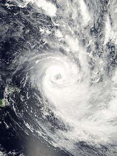
WSevere Tropical Cyclone Gita was the most intense tropical cyclone to impact Tonga since reliable records began. The second named storm and first major tropical cyclone of the 2017–18 South Pacific cyclone season, Gita originated from a monsoon trough that was active in the South Pacific in early February 2018. First classified as a tropical disturbance on 3 February, the nascent system meandered near Vanuatu for several days with little development. After acquiring a steady east trajectory near Fiji, it organized into a Category 1 tropical cyclone on 9 February near Samoa. Arcing south in a clockwise turn, the system rapidly intensified, and became a severe tropical cyclone on 10 February near Niue.
 W
WSevere Tropical Cyclone Heta was a powerful Category 5 tropical cyclone that caused moderate damage to the islands of Tonga, Niue, and American Samoa during late December 2003 and early January 2004. Heta formed on December 25, 2003; it reached a maximum intensity of 260 km/h (160 mph) and an estimated pressure of 915 hPa before dissipating on January 11, 2004. It was the first tropical cyclone to form in the area of responsibility of the regional specialised meteorological centre (RSMC) at Nadi, Fiji, during the 2003–04 South Pacific cyclone season.
 W
WSevere Tropical Cyclone Ofa was considered to be the worst tropical cyclone to affect Polynesia since Cyclone Bebe. The system was first noted on January 27, 1990, near Tuvalu, as a shallow tropical depression that had developed within the South Pacific Convergence Zone. The cloud pattern slowly organized, and on January 31, while located east of Tuvalu, Ofa attained cyclone intensity. Moving slowly southeast, Ofa developed storm-force winds. It attained hurricane-force winds on February 2. Cyclone Ofa reached peak intensity on February 4. Shortly after, its peak Ofa began to weaken over a less favourable environment. Ofa was declared an extratropical cyclone on February 8, though the system was still tracked by meteorologists until February 10.
 W
WSevere Tropical Cyclone Tino was a tropical cyclone which itself and an associated convergence zone caused significant damage across ten island nations in the South Pacific Ocean during January 2020. First noted as a tropical disturbance during January 11, to the southwest of Honiara in the Solomon Islands, the system gradually developed over the next few days as it moved eastwards in between the Solomon Islands and Vanuatu prior to being named Tino as it approached Fiji during January 16. Continuing to track south-eastward, Tino continued strengthening as it passed near Fiji, bringing copious amounts of rainfall to the area. Whilst losing latitude, the system continued to strengthen and peaked as a category 3 tropical cyclone on January 17, with signs of an eye forming. Shortly after peak intensity, Tino was impacted by high wind shear and decreasing sea surface temperatures, triggering a weakening trend. Tino moved out of the tropics shortly thereafter and became an extratropical cyclone during January 19.
 W
WSevere Tropical Cyclone Tusi was a tropical cyclone which affected the island nations of Tuvalu, Tokelau, Western Samoa, American Samoa, Niue and the Southern Cook Islands during January 1987. The precursor tropical depression to Cyclone Tusi developed on January 13, within a trough of low pressure near the island nation of Tuvalu. Over the next few days the system gradually developed further before it was named Tusi during January 16, after it had become equivalent to a modern-day category 1 tropical cyclone on the Australian tropical cyclone intensity scale. After being named the system gradually intensified as it moved southeastwards along the trough, between the islands of Fakaofo and Swains during January 17. Tusi's eye subsequently passed near or over American Samoa's Manu'a Islands early the next day, as the system peaked in intensity with 10-minute sustained wind speeds of 150 km/h (90 mph). The system subsequently posed a threat to the Southern Cook Islands, however this threat gradually diminished as Tusi moved southwards and approached 25S during January 20.
 W
WSevere Tropical Cyclone Waka was one of the most destructive tropical cyclones ever to affect the South Pacific Kingdom of Tonga. Waka originated within the near-equatorial trough in mid-December 2001, although the system remained disorganized for more than a week. The storm gradually matured and attained tropical cyclone status on December 29. Subsequently, Waka underwent rapid intensification in which it attained its peak intensity as a Category 4 severe tropical cyclone on December 31, with winds of 185 km/h (115 mph). Shortly thereafter, it passed directly over Vavaʻu, Tonga, resulting in widespread damage. By January 1, 2002, the cyclone began to weaken as it underwent an extratropical transition. The remnants of Waka persisted for several more days and were last observed near the Southern Ocean on January 6.
 W
WSevere Tropical Cyclone Winston was the most intense tropical cyclone in the Southern Hemisphere on record, as well as the strongest to make landfall in the Southern Hemisphere, with the possible exception of 1899's Cyclone Mahina in both regards. Winston is also the costliest tropical cyclone on record in the South Pacific basin. The system was first noted as a tropical disturbance on 7 February 2016, when it was located to the northwest of Port Vila, Vanuatu. Over the next few days, the system gradually developed as it moved southeast, acquiring gale-force winds by 11 February. The following day, it underwent rapid intensification and attained ten-minute maximum sustained winds of 175 km/h (110 mph). Less favourable environmental conditions prompted weakening thereafter. After turning northeast on 14 February, Winston stalled to the north of Tonga on 17 February. Due to a change in higher level steering, the storm drifted back to the west. In the process, Winston again rapidly intensified, reaching Category 5 intensity on both the Australian tropical cyclone scale and the Saffir–Simpson hurricane wind scale on 19 February. The storm passed directly over Vanua Balavu, where a national record wind gust of 306 km/h (190 mph) was observed.