 W
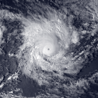
WSevere Tropical Cyclone Heta was a powerful Category 5 tropical cyclone that caused moderate damage to the islands of Tonga, Niue, and American Samoa during late December 2003 and early January 2004. Heta formed on December 25, 2003; it reached a maximum intensity of 260 km/h (160 mph) and an estimated pressure of 915 hPa before dissipating on January 11, 2004. It was the first tropical cyclone to form in the area of responsibility of the regional specialised meteorological centre (RSMC) at Nadi, Fiji, during the 2003–04 South Pacific cyclone season.
 W
WSevere Tropical Cyclone Keli was the first recorded post-season tropical cyclone to form in June within the South Pacific Ocean. The system formed on June 7, 1997, about 460 kilometers (285 mi) to the north of Tokelau. The depression gradually developed over the next few days while moving southwestward. It was designated as Tropical Cyclone Keli early the next day. Cyclone Keli intensified, slowly reaching its 10-minute peak wind speeds of 150 km/h, (90 mph), which made it a Category 3 severe tropical cyclone on the Australian Tropical Cyclone Intensity Scale. As it came under the influence of strong mid latitude westerlies and moved into an area of strong vertical wind shear, the cyclone started to weaken and was declared as extratropical on June 15.
 W
WSevere Tropical Cyclone Ofa was considered to be the worst tropical cyclone to affect Polynesia since Cyclone Bebe. The system was first noted on January 27, 1990, near Tuvalu, as a shallow tropical depression that had developed within the South Pacific Convergence Zone. The cloud pattern slowly organized, and on January 31, while located east of Tuvalu, Ofa attained cyclone intensity. Moving slowly southeast, Ofa developed storm-force winds. It attained hurricane-force winds on February 2. Cyclone Ofa reached peak intensity on February 4. Shortly after, its peak Ofa began to weaken over a less favourable environment. Ofa was declared an extratropical cyclone on February 8, though the system was still tracked by meteorologists until February 10.
 W
WCyclone Percy was the seventh named storm of the 2004–05 South Pacific cyclone season and the fourth and final severe tropical cyclone to form during the 2004–05 South Pacific cyclone season. Cyclone Percy originated as a tropical disturbance on February 23. Over the course of the next few days, the system organized while moving east-southeastward, before intensifying into a Category 1 tropical cyclone on the Australian region scale on February 26. The system quickly intensified, reaching Category 4 status later that day. On the next day, Percy was steered southward by a blocking ridge of high pressure, while stretched out the structure of the storm into an elliptical shape, weakening it back to Category 3 status. Afterward, the storm rapidly reintensified, reaching its peak intensity as a Category 5 tropical cyclone on March 2. Afterward, Percy encountered increasing wind shear and weakened once again, turning southeastward on the next day. On March 5, Percy transitioned into an extratropical storm, before dissipating soon afterward.
 W
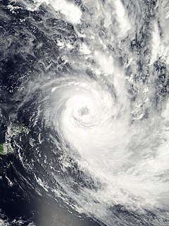
WSevere Tropical Cyclone Ron was the strongest tropical cyclone on record to impact Tonga. The system was first noted as a tropical depression, to the northeast of Samoa on January 1, 1998. Over the next day the system gradually developed further and was named Ron as it developed into a Category 1 tropical cyclone on the Australian tropical cyclone intensity scale during the next day. The system subsequently continued to move south-westwards and became a Category 3 severe tropical cyclone, as it passed near Swains Island during January 3.
 W
WSevere Tropical Cyclone Tusi was a tropical cyclone which affected the island nations of Tuvalu, Tokelau, Western Samoa, American Samoa, Niue and the Southern Cook Islands during January 1987. The precursor tropical depression to Cyclone Tusi developed on January 13, within a trough of low pressure near the island nation of Tuvalu. Over the next few days the system gradually developed further before it was named Tusi during January 16, after it had become equivalent to a modern-day category 1 tropical cyclone on the Australian tropical cyclone intensity scale. After being named the system gradually intensified as it moved southeastwards along the trough, between the islands of Fakaofo and Swains during January 17. Tusi's eye subsequently passed near or over American Samoa's Manu'a Islands early the next day, as the system peaked in intensity with 10-minute sustained wind speeds of 150 km/h (90 mph). The system subsequently posed a threat to the Southern Cook Islands, however this threat gradually diminished as Tusi moved southwards and approached 25S during January 20.
 W
WSevere Tropical Cyclone Val was considered to be the worst tropical cyclone to affect the Samoan Islands since the 1889 Apia cyclone.
 W
WSevere Tropical Cyclone Waka was one of the most destructive tropical cyclones ever to affect the South Pacific Kingdom of Tonga. Waka originated within the near-equatorial trough in mid-December 2001, although the system remained disorganized for more than a week. The storm gradually matured and attained tropical cyclone status on December 29. Subsequently, Waka underwent rapid intensification in which it attained its peak intensity as a Category 4 severe tropical cyclone on December 31, with winds of 185 km/h (115 mph). Shortly thereafter, it passed directly over Vavaʻu, Tonga, resulting in widespread damage. By January 1, 2002, the cyclone began to weaken as it underwent an extratropical transition. The remnants of Waka persisted for several more days and were last observed near the Southern Ocean on January 6.