 W
WAn atlas is a collection of maps; it is typically a bundle of maps of Earth or a region of Earth.
 W
WAndrees Allgemeiner Handatlas was a major cartographic work published in several German and foreign editions 1881–1937. It was named after Richard Andree (1835–1912) and published by Velhagen & Klasing, Bielefeld and Leipzig, Germany.
 W
WAtlante Veneto (1690-1701) was a comprehensive atlas published by the Franciscan geographer Vincenzo Maria Coronelli and intended as a continuation of the Blaeu Atlas Maior. This monumental work was published in thirteen folios and provided a wealth of detail covering ancient and modern cartographers and geographers, together with astronomical and historical data. These maps were engraved in a bold style and printed on fine white paper, the more important ones spread over two sheets, allowing for great detail.
 W
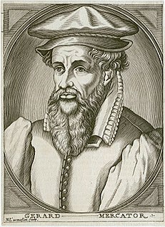
WGerardus Mercator was a 16th-century geographer, cosmographer and cartographer from the County of Flanders. He is most renowned for creating the 1569 world map based on a new projection which represented sailing courses of constant bearing as straight lines—an innovation that is still employed in nautical charts.
 W
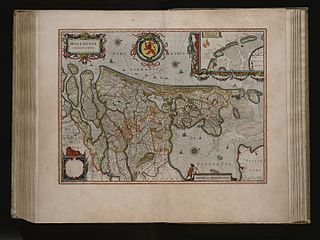
WThe Atlas der Neederlanden, or Atlas of the Netherlands, is a composite atlas which was presumably collected and composed by the publishing company Covens and Mortier in Amsterdam. The maps are gathered in nine volumes and show how the Low Countries, including Belgium and the former colonies of the Netherlands, have developed over the course of about two decades. The atlas contains more than 600 printed and manuscript maps and is preserved by the Special Collections of the University of Amsterdam.
 W
WThe Atlas des chemins vicinaux was produced in order to preserve the Belgian street network from possible usurpations. A law passed on 10 April 1841 led to the creation of an atlas of streets and roads in each town, to specify officially the Belgium public roads network.
 W
WThe Atlas do Visconde de Santarém known sometimes in English as the Viscount of Santarém's world atlas, is an important compendium lithographic reproductions of medieval European maps and navigation charts.
 W
WThe Atlas Maior is the final version of Joan Blaeu's atlas, published in Amsterdam between 1662 and 1672, in Latin, French, Dutch, German and Spanish, containing 594 maps and around 3,000 pages of text. It was the largest and most expensive book published in the seventeenth century. Earlier, much smaller versions, titled Theatrum Orbis Terrarum, sive, Atlas Novus, were published from 1634 onwards. Like Abraham Ortelius's Theatrum Orbis Terrarum (1570), the Atlas Maior is widely considered a masterpiece of the Golden Age of Dutch/Netherlandish cartography.
 W
WThe World Atlas is the Soviet and later Russian atlas of the world.
 W
WAtlas of Hồng Đức, known in Vietnamese as Hồng Đức bản đồ sách, sometimes called the Geography of Hồng Đức is a set of geographic maps of Dai Viet issued during the reign of Lê Thánh Tông, the 21st year of Hồng Đức era (1490). The atlas was made in the 8th year of Quang Thuận era (1467) when King Le Thanh Tong ordered the mandarins to draw maps from each province and send them to the Ministry of Households. The map was completed and issued in the 21st year of Hồng Đức era (1490). However, the original atlas was lost. The atlas presented the outline of the border and the administrative system of Dai Viet in the second half of the 15th century.
 W
WAtlas of Remote Islands: Fifty Islands I Have Never Set Foot On and Never Will is a book by Judith Schalansky originally published in Germany in 2009 by Mare Verlag (ISBN 978-3866481176). The atlas contains maps of 50 islands chosen by the author with accompanying descriptions of their natural and human histories, often written in a subjective, impressionistic style. It was the winner of the prize for the most beautiful German book of the year in 2009, the German Design Award in 2011, and the Red Dot Design Award in 2011. The English translation by Christine Lo was published by Penguin Books in 2010 under this title (ISBN 978-0-14311820-6) or as Pocket Atlas of Remote Islands: Fifty Islands I Have Not Visited and Never Will (ISBN 978-1-84614348-9).
 W
WThe Atlas van Loon was commissioned by Frederik Willem van Loon of Amsterdam. It consists of a large number of maps published between 1649 and 1676:Volumes I to IX: The Dutch edition of Joan Blaeu's Atlas Maior of 1663-1665 Volumes X, XI and XII: Blaeu's city books of Italy, covering the Papal States, Rome, Naples, and Sicily, all of 1663. Volumes XIII and XIV: Two volumes of the French edition of Blaeu's Atlas Maior, covering France and Switzerland, both of 1663. Volumes XV and XVI: Blaeu's Toonneel der Steeden, city books covering both the Northern and the Southern Netherlands, of 1649 Volume XVII: Pieter Goos's Zee-atlas ofte water-wereld of 1676 Volume XVIII: The French edition of Johannes Janssonius's Zeeatlas of 1657
 W
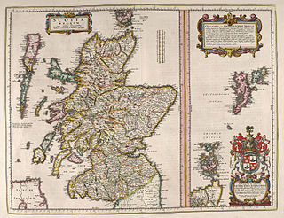
WThe Blaeu Atlas of Scotland is the first known Atlas of Scotland, compiled by Joan Blaeu, containing 49 engraved maps and 154 pages of descriptive text written in Latin and first published in 1654.
 W
WThe Bosatlas is a Dutch atlas. Used in most schools, it remains the best selling atlas in the Netherlands.
 W
WThe Atlas of the British Flora is a book by Franklyn Perring and S. Max Walters, published by the Botanical Society of the British Isles.
 W
WThe California Field Atlas is a 2017 book written and illustrated by Obi Kaufmann. It was published by Heyday Books, a Berkeley-based nonprofit small press. Through passages of nature writing and hundreds of watercolor paintings, the book details California's ecology and geography. Kaufmann, an artist and outdoorsman, was born in California and currently resides in Oakland. He prepared the book over the course of a year, drawing from a lifetime of experience hiking thousands of miles of California wilderness. With the California Field Atlas, he intended to foster geological literacy and conservation of the state's natural environment.
 W
WThe Catalan Atlas is a mediaeval world map, or mappamundi, created in 1375 that has been described as the most important map of the Middle Ages in the Catalan language, and as "the zenith of medieval map-work". Despite its name, it is not an atlas.
 W
WCedid Atlas is the first translation of the atlas in the Muslim world, printed and published in 1803 in Istanbul, then the capital of the Ottoman Empire. The full title name of the atlas reads as Cedid Atlas Tercümesi and in most libraries outside Turkey, it is recorded and referenced accordingly.
 W
WThe Cornaro Atlas is an extensive Venetian collection of nautical charts and tracts, currently held by the British Library.
 W
WDeLorme is a producer of personal satellite tracking, messaging, and navigation technology. The company’s main product, inReach, integrates GPS and satellite technologies. inReach provides the ability to send and receive text messages anywhere in the world by using the Iridium satellite constellation. By pairing with a smart phone, navigation is possible with access to free downloadable topographic maps and NOAA charts. On February 11, 2016, the company announced that it had been purchased by Garmin, a multinational producer of GPS products and services.
 W
WCarl Diercke was a German cartographer.
 W
WThe Doria Atlas is a 16th-century atlas commissioned by and named for the Genoese military leader Giovanni Andrea Doria. Likely compiled around 1570, it is a composite atlas featuring 186 printed and manuscript maps from two distinct atlases of the Lafreri school. It also contains rare Italian maps dating to the 1620s, in addition to a series of manuscript maps, written by little-known publishers during the 1620s and 1630s and detailing the commercial, political and military interests of the Doria family. As of the 21st century it is one of the world's most expensive books.
 W
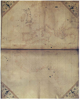
WThe Douce Atlas is an early 15th-century nautical atlas by an anonymous Italian cartographer, currently held by the Bodleian Library in Oxford, UK.
 W
WGeographers' A-Z Map Company Ltd. is the largest independent map publisher in the United Kingdom providing cartographic services, digital data products and paper mapping publications.
 W
WThe A–Z, or in full the Geographers' A–Z Street Atlas, is a name given to any one of a range of atlases of streets in the United Kingdom currently produced by Geographers' A–Z Map Company Limited. Its first atlas, of London, was originally compiled in the 1930s by Phyllis Pearsall. The company she founded now publishes street maps of many cities and towns in the UK.
 W
WThe Geography, also known by its Latin names as the Geographia and the Cosmographia, is a gazetteer, an atlas, and a treatise on cartography, compiling the geographical knowledge of the 2nd-century Roman Empire. Originally written by Claudius Ptolemy in Greek at Alexandria around AD 150, the work was a revision of a now-lost atlas by Marinus of Tyre using additional Roman and Persian gazetteers and new principles. Its translation into Arabic in the 9th century and Latin in 1406 was highly influential on the geographical knowledge and cartographic traditions of the medieval Caliphate and Renaissance Europe.
 W
WHistoAtlas is a free collection of historic geographic information of the human culture all over the world. This is achieved as a time enabled geographic information system (GIS) on the web. All information can be used and edited freely and is intended to be a resource for education, archaeologists, historians and others.
 W
WInternational Cloud Atlas is a cloud atlas that was first published in 1896 and has remained in print since then. Its initial purposes included aiding the training of meteorologists and promoting more consistent use of vocabulary describing clouds, which were both important for early weather forecasting. The first edition featured color plates of color photographs, then still a very new technology, but noted for being expensive. Numerous later editions have been published.
 W
WIslario general de todas las islas del mundo (1541) is a geography text in four volumes by Alonzo de Santa Cruz about the islands of the world.
 W
WThe Klencke Atlas, first published in 1660, is one of the world's largest atlases. Originating in The Netherlands, it is 1.75 metres tall by 1.9 metres wide when open, and so heavy the British Library needed six people to carry it.
 W
WThe cartographic Renaissance of the sixteenth century in Europe was based on a rapid increase in geographical knowledge sourced from exploration and discovery, and the European map of the world "had literally doubled in size within just over a century." Especially in the important trading centers of Rome and Venice, many individual maps were printed in Italy from about 1544. Each publisher worked independently, producing maps based upon his own customers' needs. These maps often varied greatly in size.
 W
WThe Macmillan Bible Atlas is a book on the geography, civilizations and cartography of the Holy Land. It describes the movements of biblical characters, trade routes and battles. It also refers to archaeological excavations; illustrations of artifacts; and a comparative chronology of early civilizations that relate to the Bible.
 W
WThe Medici-Laurentian Atlas, also known simply as the Medici Atlas, is an anonymous 14th-century set of maps, probably composed by a Genoese cartographer and explicitly dated 1351, although most historians believe it was composed, or at least retouched, later. The atlas is currently held by the Biblioteca Medicea Laurenziana in Florence, Italy.
 W
WThe Miller Atlas, also known as Lopo Homem-Reineis Atlas, is a richly illustrated Portuguese atlas dated from 1519, including a dozen charts. It is a joint work of the cartographers Lopo Homem, Pedro Reinel and Jorge Reinel, and illustrated by miniaturist António de Holanda.
 W
WMitchell's School Atlas is a series of textbooks written by Samuel Augustus Mitchell in the 19th century, and published by H. Cowperthwait & Company of Philadelphia, Pennsylvania.
 W
WThe National Atlas of the United States was an atlas published by the United States Department of the Interior from 1874 to 1997.
 W
WOregon Geographic Names is a compilation of the origin and meaning of place names in the U.S. state of Oregon, published by the Oregon Historical Society. The book was originally published in 1928. It was compiled and edited by Lewis A. McArthur. As of 2011, the book is in its seventh edition, which was compiled and edited by Lewis L. McArthur.
 W
WOur Dumb World is a parody of the standard desk atlas created by the staff of The Onion and published by Little, Brown and Company on October 30, 2007. It is The Onion's first book of entirely original content since 1999's Our Dumb Century.
 W
WPC Globe is an atlas for MS-DOS and Microsoft Windows, first released in 1989.
 W
WSpeculum Orbis Terrae was an atlas published by Cornelis de Jode in Antwerp in 1593. The atlas was largely a continuation of unfinished works of his father, Gerard de Jode, who died in 1591. Contemporary scholars consider many of de Jode's maps to be superior, both in detail and style, to those of the competing atlas of the time, Theatrum Orbis Terrarum, by Ortelius. However, de Jode's atlas never sold well.
 W
WStielers Handatlas, formally titled Hand-Atlas über alle Theile der Erde und über das Weltgebäude, was the leading German world atlas of the last three decades of the 19th and the first half of the 20th century. Published by Justus Perthes of Gotha it went through ten editions from 1816 to 1945. As with many 19th century publications, an edition was issued in parts; for example, the eighth edition was issued in 32 monthly parts.
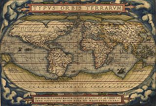
WTheatrum Orbis Terrarum is considered to be the first true modern atlas. Written by Abraham Ortelius, strongly encouraged by Gillis Hooftman and originally printed on 20 May 1570 in Antwerp, it consisted of a collection of uniform map sheets and supporting text bound to form a book for which copper printing plates were specifically engraved. The Ortelius atlas is sometimes referred to as the summary of sixteenth-century cartography. The publication of the Theatrum Orbis Terrarum (1570) is often considered as the official beginning of the Golden Age of Netherlandish cartography.
 W
WThomas Guide is the title of a series of paperback, spiral-bound atlases featuring detailed street maps of various large metropolitan areas in the United States, including Boise, Las Vegas, Los Angeles, Oakland, Phoenix, Portland, Reno-Tahoe, Sacramento, San Francisco, Seattle, Tucson, and Baltimore-Washington metropolitan area. Road Atlas titles are Arizona including Las Vegas, California Including portions of Nevada, and Pacific Northwest covering Washington, Oregon, Western Idaho, Southwestern British Columbia. The map books are usually arranged by county; for example, separate Thomas Guides have been published for Los Angeles County and San Diego County. There are also guides that will have two or three counties combined, or guides that cover a metropolitan area. Each guide has a detailed index of streets and points of interest, as well as arterial maps for easy page location.
 W
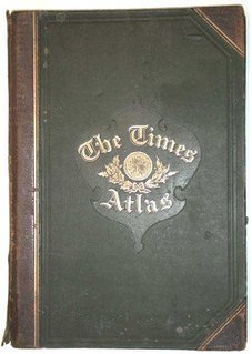
WThe Times Atlas of the World, rebranded The Times Atlas of the World: Comprehensive Edition in its 11th edition and The Times Comprehensive Atlas of the World from its 12th edition, is a world atlas currently published by HarperCollins Publisher L.L.C. Its most recent edition, the fifteenth, was published on 6 September 2018.
 W
WThe Topographic Atlas of Switzerland, also known as the Siegfried Atlas or Siegfried Map is an official map series of Switzerland. Its publication was begun by the Federal Topographic Bureau under Hermann Siegfried, and continued from 1870 to 1926. During this period the individual maps were drawn by different lithographers, including Walter Hauenstein, Georg Christian von Hoven and Rudolf Leuzinger. Since it is, in today's parlance, not strictly an atlas but a map series, map historians now describe it only by the expression Siegfried Map.
 W
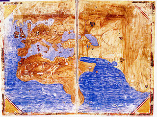
WThe Vallard Atlas is a world atlas, one of the Dieppe school of maps, produced in 1547. It is believed to have been owned by Nicolas Vallard, its authorship being unknown.
WVallard Atlas is an atlas produced in Dieppe, Northern France, in 1547. The atlas was ascribed to Nicolas Vallard. However, there is a degree of uncertainty over his authorship. Nowadays, it is believed that the Vallard Atlas was developed from an earlier Portuguese prototype.
 W
WA virtual globe is a three-dimensional (3D) software model or representation of the Earth or another world. A virtual globe provides the user with the ability to freely move around in the virtual environment by changing the viewing angle and position. Compared to a conventional globe, virtual globes have the additional capability of representing many different views on the surface of the Earth. These views may be of geographical features, man-made features such as roads and buildings, or abstract representations of demographic quantities such as population.
 W
WThe Atlas to Accompany the Official Records of the Union and Confederate Armies was published as a companion piece to the Official Records of the American Civil War. It contains maps and other images derived from materials generated by both Union and Confederate military personnel during the American Civil War.
 W
WA wind atlas contains data on the wind speed and wind direction in a region. These data include maps, but also time series or frequency distributions. A climatological wind atlas covers hourly averages at a standard height over even longer periods. But depending on the application there are variations in averaging time, height and period.
 W
WThe World Atlas of Wine by Hugh Johnson and Jancis Robinson, MW, is an atlas and reference work on the world of wine, published by Mitchell Beazley. It pioneered the use of wine-specific cartography to give wine a sense of place, and has since the first edition published in 1971 sold 4 million copies in 14 languages. Considered among the most significant wine publications to date, it remains one of the most popular books on wine, with the most recent eighth edition published in October 2019.
 W
WThe Zhifang Waiji was an atlas written by various Italian Jesuits in China in the early seventeenth century. The name literally refers to lands beyond the purview of the Zhifang Si, the Imperial cartography office. It was the first detailed atlas of global geography available in Chinese.