 W
WA star chart or star map, also called a sky chart or sky map, is a map of the night sky. Astronomers divide these into grids to use them more easily. They are used to identify and locate constellations and astronomical objects such as stars, nebulae, and galaxies. They have been used for human navigation since time immemorial. Note that a star chart differs from an astronomical catalog, which is a listing or tabulation of astronomical objects for a particular purpose. Tools utilizing a star chart include the astrolabe and planisphere.
 W
WAladin is an interactive software sky atlas allowing the user to visualize digitized astronomical images, superimpose entries from astronomical catalogues or databases, and interactively access related data and information from the SIMBAD database, the VizieR service and other archives for all known sources in the field.
 W
WChinese star maps are usually directional or graphical representations of Chinese astronomical alignments. Throughout the history of China, numerous star maps have been recorded. This page is intended to list or show the best available version of each star map. Star catalogs are also listed. For academic purposes, related star maps found in East Asia outside China are also listed.
 W
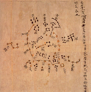
WThe Dunhuang map or Dunhuang Star map is one of the first known graphical representations of stars from ancient Chinese astronomy, dated to the Tang Dynasty (618–907). Before this map, much of the star information mentioned in historical Chinese texts had been questioned. The map provides a graphical verification of the star observations, and are part of a series of pictures on one of the Dunhuang manuscripts. The astronomy behind the map is explained in an educational resource posted on the website of the International Dunhuang Project, where much of the research on the map has been done. The Dunhuang Star map is to date the world's oldest complete preserved star atlas.
 W
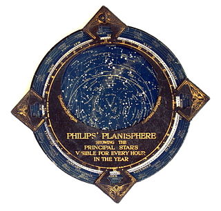
WIn astronomy, a planisphere is a star chart analog computing instrument in the form of two adjustable disks that rotate on a common pivot. It can be adjusted to display the visible stars for any time and date. It is an instrument to assist in learning how to recognize stars and constellations. The astrolabe, an instrument that has its origins in Hellenistic astronomy, is a predecessor of the modern planisphere. The term planisphere contrasts with armillary sphere, where the celestial sphere is represented by a three-dimensional framework of rings.
 W
WThe Rudolphine Tables consist of a star catalogue and planetary tables published by Johannes Kepler in 1627, using observational data collected by Tycho Brahe (1546–1601). The tables are named in memory of Rudolf II, Holy Roman Emperor, in whose employ Brahe and Kepler had begun work on the tables. The main purpose of the Rudolphine tables was to allow the computation of the positions of the then known planets of the Solar System, and they were considerably more precise than earlier such tables.
WChinese star maps are usually directional or graphical representations of Chinese astronomical alignments. Throughout the history of China, numerous star maps have been recorded. This page is intended to list or show the best available version of each star map. Star catalogs are also listed. For academic purposes, related star maps found in East Asia outside China are also listed.
 W
WUrania's Mirror; or, a view of the Heavens is a set of 32 astronomical star chart cards, first published in November 1824. They are illustrations based on Alexander Jamieson's A Celestial Atlas, but the addition of holes punched in them allow them to be held up to a light to see a depiction of the constellation's stars. They were engraved by Sidney Hall, and were said to be designed by "a lady", but have since been identified as the work of the Reverend Richard Rouse Bloxam, an assistant master at Rugby School.