A tracking system, also known as a locating system, is used for the observing of persons or objects on the move and supplying a timely ordered sequence of location data for further processing.
 W
WIn navigation, the course of a watercraft or aircraft is the cardinal direction in which the craft is to be steered. The course is to be distinguished from the heading, which is the compass direction in which the craft's bow or nose is pointed.
 W
WIn navigation, dead reckoning is the process of calculating current position of some moving object by using a previously determined position, or fix, by using estimations of speed, heading direction and course over elapsed time. The corresponding term in biology, used to describe the processes by which animals update their estimates of position or heading, is path integration.
 W
WIn the field of gesture recognition and image processing, finger tracking is a high-resolution technique developed in 1969 that is employed to know the consecutive position of the fingers of the user and hence represent objects in 3D. In addition to that, the finger tracking technique is used as a tool of the computer, acting as an external device in our computer, similar to a keyboard and a mouse.
 W
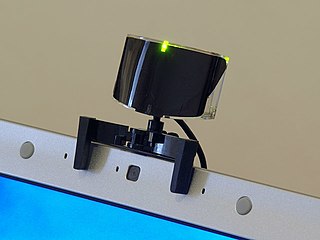
WFreeTrack is a general-purpose optical motion tracking application for Microsoft Windows, released under the GNU General Public License, that can be used with common inexpensive cameras. Its primary focus is head tracking with uses in virtual reality, simulation, video games, 3D modeling, computer aided design and general hands-free computing to improve computer accessibility. Tracking can be made sensitive enough that only small head movements are required so that the user's eyes never leave the screen.
 W
WMatch Analysis is a US company with headquarters in Emeryville, California. The company employs 70 staff in their offices and data collection facilities in California and Mexico City, Mexico.
 W
WMissile guidance refers to a variety of methods of guiding a missile or a guided bomb to its intended target. The missile's target accuracy is a critical factor for its effectiveness. Guidance systems improve missile accuracy by improving its Probability of Guidance (Pg).
 W
WPackage tracking or package logging is the process of localizing shipping containers, mail and parcel post at different points of time during sorting, warehousing, and package delivery to verify their provenance and to predict and aid delivery.
 W
WRailRadar GPS is a live tracker allowing users to watch the movements of passenger trains running in India on an interactive map. All passenger trains in India are operated by state-owned Indian Railways. In the first release the location and status of trains shown on the map was typically 15 to 30 minutes delayed from real-time. RailRadar was created when Indian Railways Center for Railway Information System (CRIS) and RailYatri joined hands, and the service was launched on 10 October 2012. RailRadar uses Google Maps as its web mapping software, and is accessible in the form of a website and a mobile app. RailRadar was discontinued by Indian Railways on 6 September 2013, before RailYatri relaunched it in November 2013. However the RailRadar service did not provide the actual running status or the actual location of the train, rather these locations were plotted based on the regular scheduled timetable.
 W
WRedtail Telematics is a provider of GPS enabled fleet tracking products. The company is based in North America with headquarters in the United Kingdom. Redtail's products use a technology solution known as VAM which includes features such asGPS jamming/tamper protection alerts Motion sensors Vehicle status engine detection Onboard diagnostics.
 W
WSmartWater is a traceable liquid and forensic asset marking system (taggant) that is applied to items of value to identify thieves and deter theft. The liquid leaves a long lasting and unique identifier, whose presence is invisible except under an ultraviolet black light.
A solar tracker is a device that orients a payload toward the Sun. Payloads are usually solar panels, parabolic troughs, fresnel reflectors, lenses or the mirrors of a heliostat.
 W
WTracking in hunting and ecology is the science and art of observing animal tracks and other signs, with the goal of gaining understanding of the landscape and the animal being tracked. A further goal of tracking is the deeper understanding of the systems and patterns that make up the environment surrounding and incorporating the tracker.
A Tracking trial is an event to encourage dogs to make use of their strongest facility, the ability to follow a scent trail. The competition emulates the finding of a lost person or article in a situation where the performance of the dog can be fairly assessed. Because of this, the tracks laid are straightforward, not the wanderings that may characterize a lost person, nor do they include deliberate attempts by the tracklayer to deceive the dog.
 W
WTrackIR is an optical motion tracking game controller for Microsoft Windows created by NaturalPoint Inc.. TrackIR tracks head motions with up to six degrees of freedom (6DOF) in later models, allowing handsfree view control for improved game immersiveness and situational awareness. Head position and orientation are measured by a purpose-built video camera, mounted on top of the user's monitor, which observes invisible infrared (IR) light reflected or emitted by markers on a rigid model worn by the user. TrackIR software is used to access and control the camera, as well as adjust tracking and manage game profiles. The ratio of actual head movement to virtual head movement can be changed, allowing the virtual head to turn 180 degrees whilst the user still looks at the monitor.
In virtual reality (VR), positional tracking detects the precise position of the head-mounted displays, controllers, other objects or body parts within Euclidean space. Because the purpose of VR is to emulate perceptions of reality, it is paramount that positional tracking be both accurate and precise so as not to break the illusion of three-dimensional space. Several methods of tracking the position and orientation of the display and any associated objects or devices have been developed to achieve this. All of said methods utilize sensors which repeatedly record signals from transmitters on or near the tracked object(s), and then send that data to the computer in order to maintain an approximation of their physical locations. By and large, these physical locations are identified and defined using one or more of three coordinate systems: the Cartesian rectilinear system, the spherical polar system, and the cylindrical system. Many interfaces have also been designed to monitor and control one’s movement within and interaction with the virtual 3D space; such interfaces must work closely with positional tracking systems to provide a seamless user experience.