 W
WA weather station is a facility, either on land or sea, with instruments and equipment for measuring atmospheric conditions to provide information for weather forecasts and to study the weather and climate. The measurements taken include temperature, atmospheric pressure, humidity, wind speed, wind direction, and precipitation amounts. Wind measurements are taken with as few other obstructions as possible, while temperature and humidity measurements are kept free from direct solar radiation, or insolation. Manual observations are taken at least once daily, while automated measurements are taken at least once an hour. Weather conditions out at sea are taken by ships and buoys, which measure slightly different meteorological quantities such as sea surface temperature (SST), wave height, and wave period. Drifting weather buoys outnumber their moored versions by a significant amount.
 W
WAlert, in the Qikiqtaaluk Region, Nunavut, Canada, is the northernmost permanently inhabited place in the world, located on Ellesmere Island at latitude 82°30'05" north, 817 kilometres (508 mi) from the North Pole. As of the 2016 census, the population was reported as 62. It takes its name from HMS Alert, which wintered 10 km (6.2 mi) east of the present station, off what is now Cape Sheridan, in 1875–1876.
 W
WBaccaro is a community in the Canadian province of Nova Scotia, located in the Barrington Municipal District.
 W
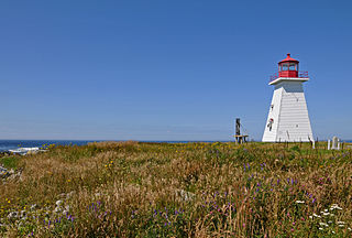
WBeaver Island is an island community of the Halifax Regional Municipality in the Canadian province of Nova Scotia. The weather station code is CWBV; due to its exposed location, Beaver Island can receive very powerful winds, especially from offshore. Since 1846 there has been a lighthouse on the island.
 W
WThe Berkeley Building is a 26-story, 495-foot (151 m) building located at 200 Berkeley Street, Boston, Massachusetts, USA. It is the second of the three John Hancock buildings built in Boston; it was succeeded by the John Hancock Tower. The building is known for the weather beacon at its summit, which broadcasts light patterns as weather forecasts. The Berkeley Building is the 20th-tallest building in the city.
 W
WBiały Słoń is a Polish name for an abandoned campus of the former Polish Astronomical and Meteorological Observatory of Warsaw University, located at remote area on the peak of Pip Ivan in the Chornohora range of the Carpathian Mountains, Ukraine. Currently the structure is used as a mountain shelter with a small search and rescue team with some rooms adopted for lodging and recovery.
 W
WBorder Beacon was a RCAF military installation in Labrador, located approximately 190 km west of the Town of Hopedale. Border Beacon was a bistatic radar Doppler Detection Station on the Mid-Canada Line system of early-warning radar stations.
 W
WThe Canada Life Building is a historic office building in Toronto, Ontario, Canada. The fifteen-floor Beaux Arts building was built by Sproatt & Rolph and stands at 285 feet (87 m), 321 feet (97.8 m) including its weather beacon.
 W
WEureka is a small research base on Fosheim Peninsula, Ellesmere Island, Qikiqtaaluk Region, in the Canadian territory of Nunavut. It is located on the north side of Slidre Fiord, which enters Eureka Sound farther west. It is the third-northernmost permanent research community in the world. The only two farther north are Alert, which is also on Ellesmere Island, and Nord, in Greenland. Eureka has the lowest average annual temperature and the lowest amount of precipitation of any weather station in Canada.
 W
WFalsterbo Lighthouse. To the north-east of the lighthouse is the city of Skanör-Falsterbo, to the south-east of the lighthouse are some of the finest sandy beaches in Sweden and surrounding the lighthouse is the golf course of the Falsterbo Golf Club.
 W
WFinnsbu was a Norwegian hunting, meteorological and radio station located on the King Frederick VI Coast, Southeastern Greenland.
 W
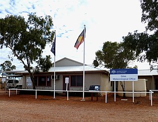
WGiles Weather Station is located in Western Australia near the Northern Territory border, about 750 kilometres (470 mi) west-south-west of Alice Springs and 330 kilometres (210 mi) west of Uluru. It is the only staffed weather station within an area of about 2,500,000 square kilometres (970,000 sq mi) and is situated mid-continent and near the core of the subtropical jetstream. This means it plays an important role as a weather and climate observatory for the country, particularly eastern and southeastern Australia, and particularly for rainfall predictions. The station is on the Great Central Road and the nearest township is the Warakurna Aboriginal settlement, 5 kilometres (3 mi) North. Giles is within the Shire of Ngaanyatjarraku and is in the foothills of the Rawlinson Ranges.
 W
WThe Hatteras Weather Bureau Station is a wood-frame building in Hatteras, North Carolina built in 1901 for what was then called the U.S. Weather Bureau. The then-remote location on the Outer Banks of North Carolina provided data on conditions in the Atlantic Ocean from a fixed location that was farther into the ocean environment than any on the Atlantic coast. The building served as a weather station from 1902 to 1946, when it was converted to living quarters for Weather Bureau personnel. In 1952 the property was turned over to the U.S. Coast Guard, which used it until 1958, when it was transferred to the National Park Service for use by Cape Hatteras National Seashore. From 1958 to 1976 the building was used as a research station, first by Duke University and later by North Carolina State University for investigations concerning marine invertebrates.
 W
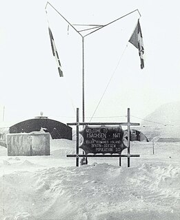
WIsachsen is a remote Arctic research-weather station named after the Norwegian explorer of the Arctic, Gunnar Isachsen. It is on the western shore of Ellef Ringnes Island in the Sverdrup Islands, in the territory of Nunavut in Canada. Isachsen Station was established to participate in a joint Canadian-American weather observation program. Isachsen Station operated from April 3, 1948 through September 19, 1978. Regular weather observations began on May 3, 1948. In October 1949, a Douglas C-47 Skytrain crash-landed near the station. No one was killed, but three on board were injured. The wreckage has been preserved by the cold weather and dry conditions.
 W
WKCCI, virtual and VHF digital channel 8, is a CBS-affiliated television station licensed to Des Moines, Iowa, United States. The station is owned by the Hearst Television subsidiary of Hearst Communications. KCCI's studios are located on Ninth Street in downtown Des Moines, and its transmitter is located in Alleman, Iowa. On cable, the station is available on Mediacom channel 8 in standard definition and on digital channel 808 in high definition.
KXTV, virtual and VHF digital channel 10, is an ABC-affiliated television station licensed to Sacramento, California, United States. The station is owned by Tegna Inc. KXTV's studios are located on Broadway, just south of U.S. Highway 50 at the south edge of downtown Sacramento, and its transmitter is located in Walnut Grove.
WMalay Falls is a small rural community on the Eastern Shore of Nova Scotia, Canada, in the Halifax Regional Municipality. The community is located along Route 374 and is about 11 km (6.8 mi) northeast of Sheet Harbour. The community is located along East River, and is adjacent to the Malay Falls Flowage, a lake along the river's course. Malay Falls was first settled in 1784. Colin Malay acquired land here in 1849, when the area was called Salmon River. The Government of Canada maintains a weather station in the community.
 W
WMalin Head is located on the Inishowen Peninsula, County Donegal, Ireland and is the most northerly point of mainland Ireland. The northernmost tip is the headland called Dúnalderagh and is located at latitude 55.38ºN. Malin Head gives its name to the Malin sea area. Malin Head encompasses an area north of the Black Mountain, there is no specific point which details the location of Malin Head and the area is peppered with many local place names of Norse and Irish origin. There is a weather station on the head, which is one of 22 such stations whose reports are broadcast as part of the BBC Shipping Forecast. A tower built in 1805 is situated on Altnadarrow also known locally as the Tower hill.
 W
WThe Mercantile National Bank Building is a 31-story, 159.4 m (523 ft) skyscraper at 1800 Main Street in the Main Street district of downtown Dallas, Texas. It is the former home of the Mercantile National Bank, which later became MCorp Bank. The design of the skyscraper features Moderne styling from the Art Deco era and was designed by Walter W. Ahlschlager. The building has a series of setbacks that is crowned by an ornamental four-sided clock along with a decorative weather spire. The Merc was the main element of a four-building complex that eventually spanned a full city block.
 W
WMolodyozhnaya was a Soviet, then Russian research station in East Antarctica at 67°40′S 45°50′E. After being mothballed in 1990, it was reopened in 2006 to operate on a seasonal basis. In Russian, the station is sometimes referred to as the capital of Antarctica.
 W
WThe Navy oceanographic meteorological automatic device (NOMAD) is an anchored automated weather station developed shortly after World War II and still used today.
Norwest Corporation was a banking and financial services company based in Minneapolis, Minnesota, United States. In 1998, it merged with Wells Fargo & Co. and since that time has traded under the Wells Fargo name.
 W
WThe Nottingham Weather Centre is a functioning observation and weather station located in Watnall, Nottinghamshire in England. The weather station is located 5.6 miles (9.0 km) from the city centre of Nottingham, and is the closest weather station to Nottingham with observations.
 W
WOne Rincon Hill is an upscale residential complex on the apex of Rincon Hill in San Francisco, California, United States. The complex, designed by Solomon, Cordwell, Buenz and Associates and developed by Urban West Associates, consists of two skyscrapers that share a common townhouse podium. It is part of the San Francisco Skyline and is visible from Mt. Diablo, Port of Oakland and San Francisco.
 W
WMS Polarfront was a Norwegian weather ship located in the North Atlantic Ocean. It was the last remaining weather ship in the world, maintained by the Norwegian Meteorological Institute.
 W
WProgress is a Russian research station in Antarctica. It is located at the Larsemann Hills antarctic oasis on the shore of Prydz Bay.
 W
WThe Remote Automatic Weather Stations (RAWS) system is a network of automated weather stations run by the U.S. Forest Service (USFS) and Bureau of Land Management (BLM) and monitored by the National Interagency Fire Center (NIFC), mainly to observe potential wildfire conditions.
 W
WA Road Weather Information System (RWIS) comprises automatic weather stations in the field, a communication system for data transfer, and central systems to collect field data from numerous ESS. These stations measure real-time atmospheric parameters, pavement conditions, water level conditions, and visibility. Central RWIS hardware and software are used to process observations from ESS to develop nowcasts or forecasts, and display or disseminate road weather information in a format that can be easily interpreted by a manager. RWIS data are used by road operators and maintainers to support decision making. Real-time RWIS data is also used by Automated Warning Systems (AWS). The spatial and temporal resolution can be that of a mesonet. The data is often considered proprietary although it is often ingested into numerical weather prediction models.
 W
WThe Ross-on-Wye weather station is a weather station, now fully automated, situated off the Walford Road in Ross-on-Wye, Herefordshire, England.
 W
WSevenstones Lightship is a lightship moored off the Seven Stones Reef which is nearly 15 miles (24 km) to the west-north-west (WNW) of Land's End, Cornwall, and 7 miles (11 km) east-north-east (ENE) of the Isles of Scilly. The reef has been a navigational hazard to shipping for centuries with seventy-one named wrecks and an estimated two hundred shipwrecks overall, the most infamous being the oil tanker Torrey Canyon on 18 March 1967. The rocks are only exposed at half tide. Since it was not feasible to build a lighthouse, a lightvessel was provided by Trinity House. The first was moored near the reef on 20 August 1841 and exhibited its first light on 1 September 1841. She is permanently anchored in 40 fathoms (73 m) and is 2.5 miles (4.0 km) north-east (NE) of the reef. Since 1987, the Sevenstones Lightship has been automated and unmanned.
 W
WSNOTEL is an automated system of snowpack and related climate sensors operated by the Natural Resources Conservation Service (NRCS) of the United States Department of Agriculture in the Western United States.
 W
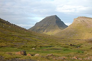
WSornfelli is a mountain plateau on the island of Streymoy in the Faroe Islands about 12 km from the capital Tórshavn. It is the site of a military station at 725m above sea level (asl). The Sornfelli Meteorological Station installed in 1999 is located in the middle of the 40,000 m2 Sornfelli Mountain top plateau, also at 725m asl.
WStorfjord was a Norwegian hunting, meteorological and radio station ("Storfjord/LMR") located in King Christian IX Land, Eastern Greenland.
WThe Sutton Bonington weather station is a functioning weather station located in Sutton Bonington, Nottinghamshire in England. The weather station is located 9.0 miles (14.5 km) from the city centre of Nottingham and 4.7 miles (7.6 km) from the town centre of Loughborough. The Sutton Bonington station was formerly Nottingham's main weather station.
WTorgilsbu was a Norwegian hunting, meteorological and radio station located on the King Frederick VI Coast, Southeastern Greenland.
 W
WThe Transmitter Hamburg-Billstedt is a broadcasting facility in Hamburg-Billstedt, established in 1934. It is owned and operated by the Norddeutscher Rundfunk public broadcasting service, but open to competitors, too.
 W
WThe VDNKh weather station is the principal weather station in Moscow, Russia. It opened in 1948 on the grounds of the All-Russia Exhibition Centre. Temperature and precipitation readings at VVC weather station form the official weather reports and historical statistics.
 W
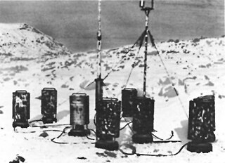
WWeather Station Kurt was an automatic weather station, erected by a German U-boat crew in northern Labrador, Dominion of Newfoundland in October 1943. Installing the equipment for the station was the only known armed German military operation on land in North America during the Second World War. After the war it was forgotten until its rediscovery in 1977.
WWestern Head is a community in the Canadian province of Nova Scotia, located in the Region of Queens Municipality. The Meteorological Service of Canada maintains a weather station in Western Head ID: CWWE.