 W
WThe Bangladesh–India border, known locally as the International Border (IB), is an international border running between Bangladesh and India that demarcates the eight divisions of Bangladesh and the Indian states.
 W
WBarahoti, located in the Indian state of Uttarakhand, is an 80 square kilometres (31 sq mi) sloping pasture under Indian administration claimed by China since June 1954. Barahoti was the first location in Indian territory to be claimed by China, and notably, the Chinese did not know the exact location of Barahoti when claiming it.
 W
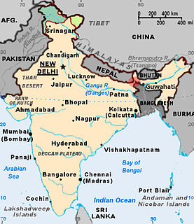
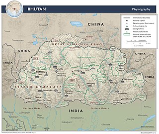
WThe Bhutan–India border is the international border separating Bhutan and India. The border is 699 km long, and adjoins the Indian states of Assam, Arunachal Pradesh, West Bengal, and Sikkim.
 W
WIndia has the 18th-largest exclusive economic zone (EEZ) with a total size of 2,305,143 km2 (890,021 sq mi). It includes the Lakshadweep island group in the Laccadive Sea off the southwestern coast of India and the Andaman and Nicobar Islands at the Bay of Bengal and the Andaman Sea. India's EEZ is bordered to the west by Pakistan, to the south by the Maldives and Sri Lanka and to the east by Bangladesh, Myanmar, Thailand, Malaysia and Indonesia.
 W
WThe India–Myanmar border is the international border between the India and Myanmar. The border is 1,468 km in length and runs from the tripoint with China in the north to the tripoint with Bangladesh in the south.
 W
WThe India–Nepal border is an open international border running between India and Nepal. The 1,770 km (1,099.83 mi) long border includes the Himalayan territories as well as Indo-Gangetic Plain. The current border was delimited after the Sugauli treaty of 1816 between Nepal and the British Raj. Following Indian independence, the current border was recognised as the border between Nepal and the Republic of India.
 W
WThe Pakistan–India Border, known locally as the International Border (IB), is an international border running between Pakistan and India. The border runs from the Line of Control (LoC), which separates Indian-administered Kashmir from Pakistan-administered Kashmir, in the north, to the Sir Creek in Rann of Kutch between the Indian state of Gujarat and the Sindh province of Pakistan, in the south.
 W
WThe Kalapani territory is an area under Indian administration as part of Pithoragarh district in the Uttarakhand state, but is also claimed by Nepal since 1997. According to Nepal's claim, it lies in Darchula district, Sudurpashchim Pradesh. The territory represents the basin of the Kalapani river, one of the headwaters of the Kali River in the Himalayas at an altitude of 3600–5200 meters. The valley of Kalapani, with the Lipulekh Pass at the top, forms the Indian route to Kailash–Manasarovar, an ancient pilgrimage site. It is also the traditional trading route to Tibet for the Bhotiyas of Uttarakhand and Tinkar valley.
 W
WThe Laccadive Sea or Lakshadweep Sea is a body of water bordering India, the Maldives, and Sri Lanka. It is located to the southwest of Karnataka, to the west of Kerala and to the south of Tamil Nadu. This warm sea has a stable water temperature through the year and is rich in marine life, the Gulf of Mannar alone hosting about 3,600 species. Mangaluru, Kannur, Kozhikode, Ponnani, Kochi, Alappuzha, Kollam, Thiruvananthapuram, Tuticorin, Colombo, and Malé are the major cities on the shore of the Laccadive Sea. Kanyakumari, the southernmost tip of peninsular India, also borders this sea.
The Land Ports Authority of India or LPAI is a statutory body working under the Ministry of Home Affairs, Government of India is responsible for creating, upgrading, maintaining and managing border infrastructure in India. It managess several Integrated Check Posts (ICPs) all across Borders of India.
WThe Siliguri Corridor, also known as the Chicken's Neck, is a narrow stretch of land of about 22 kilometres (14 mi) width, located in the Indian state of West Bengal, that connects India's northeastern states to the rest of India, with the countries of Nepal and Bangladesh lying on either side of the corridor. The Kingdom of Bhutan lies on the northern side of the corridor. The Kingdom of Sikkim formerly lay on the northern side of the corridor, until its merger with India in 1975.
 W
WThe Tetulia Corridor is a proposed 4 to 6 kilometres passage that would connect the political subdivision of Chopra in North Dinajpur district to the towns of Jalpaiguri and Mainaguri in Jalpaiguri district in the Indian state of West Bengal, through Tetulia Upazila in Bangladesh. The government of India has taken up the opening of the corridor with the government of Bangladesh. The corridor would reduce the travel distance by about 84 km (52 mi) and facilitate easier access to Northeast India.