 W
WGeology of Colombia refers to the geological composition of the Republic of Colombia that determines its geography. Most of the emerged territory of Colombia covers vast areas within the South American plate, whereas much submerged territory lies within the Caribbean plate and the Nazca plate.
 W
WThe Andean orogeny is an ongoing process of orogeny that began in the Early Jurassic and is responsible for the rise of the Andes mountains. The orogeny is driven by a reactivation of a long-lived subduction system along the western margin of South America. On a continental scale the Cretaceous and Oligocene were periods of re-arrangements in the orogeny. Locally the details of the nature of the orogeny varies depending on the segment and the geological period considered.
 W
WThe Caribbean Terrane is one of the geological provinces (terranes) of Colombia. The terrane, dating to the Late Cretaceous, is situated on the North Andes Plate and borders the La Guajira, Chibcha and underlying Tahamí Terrane along the regional Bucaramanga-Santa Marta Fault. The terrane overlies the Tahamí, Arquía and Quebradagrande Terranes along the Romeral Fault System.
WThe Chibcha Terrane, named after Chibcha, is the largest of the geological provinces (terranes) of Colombia. The terrane, the oldest explored domains of which date to the Meso- to Neoproterozoic, is situated on the North Andes Plate. The megaregional Romeral Fault System forms the contact of the terrane with the Tahamí Terrane. The contact with the Caribbean and La Guajira Terranes is formed by the regional Bucaramanga-Santa Marta Fault. The northeastern boundary is formed by the regional Oca Fault, bounding the La Guajira Terrane. The terrane is emplaced over the Río Negro-Juruena Province of the Amazonian Craton along the megaregional Eastern Frontal Fault System.
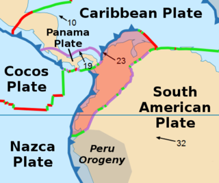
WThe Coiba Plate is a small tectonic plate (microplate) located off the coasts south of Panama and northwestern Colombia. It is named after Coiba, the largest island of Central America, just north of the plate offshore southern Panama. It is bounded on the west by the Cocos Plate, on the south by the Malpelo Plate, on the east by the North Andes Plate, and on the north by the Panama Plate. This microplate was previously assumed to be part of the Nazca Plate, forming the northeastern tongue of the Nazca Plate together with the Malpelo Plate. Bordering the Coiba Plate on the east are the north-south striking Bahía Solano Fault and east of that, the Serranía de Baudó, an isolated mountain chain in northwestern Chocó, Colombia.
The Colombian Geological Survey (CGS) is a scientific agency of the Colombian government in charge of contributing to the socioeconomic development of the nation through research in basic and applied geosciences of the subsoil, the potential of its resources, evaluating and monitoring threats of geological origin, managing the geoscientific knowledge of the nation, and studying the nuclear and radioactive elements in Colombia.
 W
WThe Guiana Shield is one of the three cratons of the South American Plate. It is a 1.7 billion-year-old Precambrian geological formation in northeast South America that forms a portion of the northern coast. The higher elevations on the shield are called the Guiana Highlands, which is where the table-like mountains called tepuis are found. The Guiana Highlands are also the source of some of the world's most well-known waterfalls such as Angel Falls, Kaieteur Falls and Kuquenan Falls.
WLa Guajira Terrane is one of the geological provinces (terranes) of Colombia. The terrane, dating to the Late Cretaceous, is situated on the North Andes Plate and borders the Caribbean, Tahamí and Chibcha Terranes along the Bucaramanga-Santa Marta Fault. The southern boundary is formed by the Oca Fault with the Chibcha Terrane.
WThe Malpelo Plate is a small tectonic plate (microplate) located off the coasts west of Ecuador and Colombia. It is the 57th plate to be identified. It is named after Malpelo Island, the only emerged part of the plate. It is bounded on the west by the Cocos Plate, on the south by the Nazca Plate, on the east by the North Andes Plate, and on the north by the Coiba Plate, separated by the Coiba Transform Fault (CTF). This microplate was previously assumed to be part of the Nazca Plate. The Malpelo Plate borders three major faults of Pacific Colombia, the north to south striking Bahía Solano Fault in the north and the Naya-Micay and Remolino-El Charco Faults in the south.
 W
WThis is a list of mining areas in Colombia. The mineral industry of Colombia is large and diverse; the country occupies the first place in mining areas per surface area in the world. In pre-Columbian times, mining of gold, silver, copper, emeralds, salt, coal and other minerals was already widespread. Precious metals as gold, and silver, platinum, nickel and coltan are located in different areas throughout the country. Colombia is the first producer of emeralds and as per February 2017 occupied a ninth position in the production of coal, produced in almost all of the departments of the country. Platinum is mostly found in the Western and Central Ranges of the Colombian Andes. Copper said to have been produced during colonial and later times apparently came from small shoots which may have been worked primarily for their gold content. The largest gold mine in Colombia is scheduled to start operations in Buriticá, Antioquia.
 W
WThe North Andes Plate or North Andes Block is a small tectonic plate (microplate) located in the northern Andes. It is squeezed between the faster moving South American Plate and the Nazca Plate to the southwest. Due to the subduction of the Malpelo and Coiba Plates, this area is very prone to volcanic and seismic activity, with many historic earthquakes.
 W
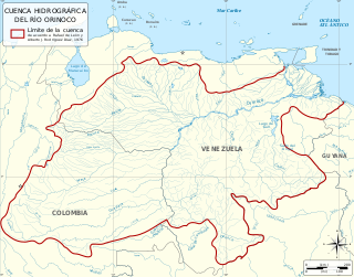
WThe Orinoco Basin is the part of South America drained by the Orinoco river and its tributaries. The Orinoco watershed covers an area of about 990000 km2, making it the third largest in South America, covering most of Venezuela and eastern part of Colombia.
 W
WThe Panama Plate is a microplate; a small tectonic plate that exists between two actively spreading ridges and moves relatively independently of its surrounding plates. The Panama plate is located between the Cocos Plate and Nazca Plate to the south and the Caribbean Plate to the north. Most of its borders are convergent boundaries including a subduction zone to the west. It consists, for the most part, of the nations of Panama and Costa Rica.
 W
WThe South American Plate is a major tectonic plate which includes the continent of South America as well as a sizable region of the Atlantic Ocean seabed extending eastward to the African Plate, with which it forms the southern part of the Mid-Atlantic Ridge.
WThe Tahamí or Tahamí-Panzenú Terrane is one of the geological provinces (terranes) of Colombia. The terrane, dating to the Permo-Triassic, is situated on the North Andes Plate. The contact with the Chibcha, Arquía and Quebradagrande Terranes is formed by the megaregional Romeral Fault System. A tiny terrane is located at the contact with the Quebradagrande Terrane; Anacona Terrane.