 W
WApple Island is a 35-acre (140,000 m2) island that lies in the middle of Orchard Lake, in Orchard Lake Village, Michigan. The island was formed during the region's last ice age, 10,000 to 12,000 years ago. Over 400 species of flora currently inhabit the island, including many rare varieties in Oakland County. Native Americans previously inhabited Apple Island, until ceding the island to the United States in the Treaty of Detroit. Currently, the West Bloomfield School District uses the island as an educational nature center.
 W
WThe colony of Canada was a French colony within the larger territory of New France, first claimed in the name of the king of France in 1535 during the second voyage of Jacques Cartier, later to become largely part of the modern country of Canada. The word "Canada" at this point referred to the territory along the Saint Lawrence River, then known as the Canada river, from Grosse Island in the east to a point between Quebec and Trois-Rivières, although this territory had greatly expanded by 1600. French explorations continued "unto the Countreys of Canada, Hochelaga, and Saguenay" before any permanent settlements were established. Even though a permanent trading post and habitation was established at Tadoussac in 1600, at the confluence of the Saguenay and Saint Lawrence rivers, it was under a trade monopoly and thus not constituted as an official French colonial settlement.
 W
WCharlotina was the suggested name for a popularly proposed British crown colony which was to be established in America following the end of the Seven Years' War, in which Great Britain had acquired a large portion of New France in 1763. However, the proposal was met with little official enthusiasm, as the British government's Royal Proclamation of 1763 forbade the creation of new colonies in the Mississippi and Ohio Valleys. Had such a colony been founded, it would have included the region lying west of the Maumee and Wabash rivers; north of the Ohio River; east of the upper Mississippi River; and south of the Great Lakes. These boundaries would include portions of modern-day Minnesota, Ohio, Indiana, and the entirety of Michigan, Illinois, and Wisconsin. Charlotina would have included modern-day cities such as Chicago, Milwaukee, Toledo, Detroit, Fort Wayne, and parts of Minneapolis and St. Paul.
 W
WFort Gratiot was an American stockade fort in Fort Gratiot, Michigan, in Saint Clair County, Michigan. The former location of the fort was listed on the National Register of Historic Places in 1980.
 W
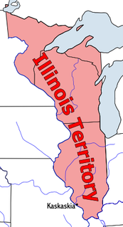
WThe Territory of Illinois was an organized incorporated territory of the United States that existed from March 1, 1809, until December 3, 1818, when the southern portion of the territory was admitted to the Union as the State of Illinois. Its capital was the former French village of Kaskaskia.
 W
W"Indian Reserve" is a historical term for the largely uncolonized area in North America acquired by Great Britain from France through the Treaty of Paris (1763) at the end of the Seven Years' War, and set aside in the Royal Proclamation of 1763 for use by Native Americans, who already inhabited it. The British government had contemplated establishing an Indian barrier state in the portion of the reserve west of the Appalachian Mountains, and bounded by the Ohio and Mississippi rivers and the Great Lakes. British officials aspired to establish such a state even after the region was assigned to the United States in the Treaty of Paris (1783) ending the American Revolutionary War, but abandoned their efforts in 1814 after losing military control of the region during the War of 1812.
 W
WThe Indiana Territory was created by a congressional act that President John Adams signed into law on May 7, 1800, to form an organized incorporated territory of the United States that existed from July 4, 1800, to December 11, 1816, when the remaining southeastern portion of the territory was admitted to the Union as the state of Indiana. The territory originally contained approximately 259,824 square miles (672,940 km2) of land, but its size was decreased when it was subdivided to create the Michigan Territory (1805) and the Illinois Territory (1809). The Indiana Territory was the first new territory created from lands of the Northwest Territory, which had been organized under the terms of the Northwest Ordinance of 1787. The territorial capital was the settlement around the old French fort of Vincennes on the Wabash River, until transferred to Corydon near the Ohio River in 1813.
 W
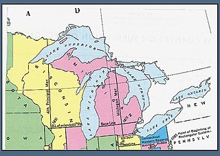
WThe Michigan meridian is the principal meridian used as a reference in the Michigan Survey, the survey of the U.S. state of Michigan in the early 19th century. It is located at 84 degrees, 21 minutes and 53 seconds west longitude at its northern terminus at Sault Ste. Marie, and varies very little from that line down the length of the state.
 W
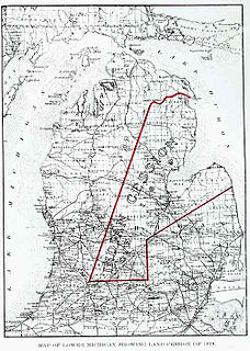
WThe Territory of Michigan was an organized incorporated territory of the United States that existed from June 30, 1805, until January 26, 1837, when the final extent of the territory was admitted to the Union as the State of Michigan. Detroit was the territorial capital.
 W
WThe Northwest Territory, also known as the Old Northwest and formally known as the Territory Northwest of the River Ohio, was formed in the United States after the American Revolutionary War. Established in 1787 by the Congress of the Confederation through the Northwest Ordinance, it was the nation's first post-colonial organized incorporated territory.
WThe Province of Quebec was a colony in North America created by Great Britain in 1763 after the Seven Years' War. During the war, Great Britain's forces conquered French Canada. As part of terms of the Treaty of Paris peace settlement, France gave up its claim to Canada and negotiated to keep the small but rich sugar island of Guadeloupe instead. By Britain's Royal Proclamation of 1763, Canada was renamed the Province of Quebec. The new British province extended from the coast of Labrador on the Atlantic Ocean, southwest through the Saint Lawrence River Valley to the Great Lakes and beyond to the confluence of the Ohio and Mississippi Rivers. Portions of its southwest were later ceded to the United States in the Treaty of Paris (1783) at the conclusion of the American Revolution although the British maintained a military presence there until 1796. In 1791, the territory north of the Great Lakes was divided into Lower Canada and Upper Canada.
 W
WSandy Creek is an 18.5-mile-long (29.8 km) creek located entirely within Monroe County in the U.S. state of Michigan. The creek rises in London Township in the north-central portion of the county and flows southeast into Lake Erie in Frenchtown Charter Township at Sterling State Park.
 W
WHenry Rowe Schoolcraft was an American geographer, geologist, and ethnologist, noted for his early studies of Native American cultures, as well as for his 1832 expedition to the source of the Mississippi River. He is also noted for his major six-volume study of Native Americans published in the 1850s.
 W
WThe Treaty of Chicago may refer to either of two treaties made and signed in the settlement that became Chicago, Illinois between the United States and the Odaawaa, Ojibwe, and Bodéwadmi Native American peoples. The first was in 1821 and the second in 1833.
 W
WThe Treaty of Detroit was a treaty between the United States and the Ottawa, Chippewa, Wyandot and Potawatomi Native American nations. The treaty was signed at Detroit, Michigan on November 17, 1807, with William Hull, governor of the Michigan Territory and superintendent of Indian affairs, the sole representative of the U.S.
 W
WThe Treaty of Saginaw, also known as the Treaty with the Chippewa, was made between Gen. Lewis Cass and Chief Mash Kee Yosh, Chief John Okemos, Chief Wasso and other Native American tribes of the Great Lakes region in what is now the United States, on September 24, 1819, proclaimed by the President of the United States on March 25, 1820, and placed in law as 7 Stat. 203.