 W
WThe Anker Site (11Ck-21) is located on the Little Calumet River near Chicago, Illinois. It is classified as a late Prehistoric site with Upper Mississippian Huber affiliation.
 W
WThe Cache River is a 92-mile-long (148 km) waterway in southernmost Illinois, in a region sometimes called Little Egypt. The basin spans 737 square miles (1,910 km2) and six counties: Alexander, Johnson, Massac, Pope, Pulaski and Union. Located at the convergence of four major physiographic regions, the river is part of the largest complex of wetlands in Illinois. The Cache River Wetlands — America's northernmost cypress/tupelo swamp — harbors 91 percent of the state's high quality swamp and wetland communities. It provides habitat for more than 100 threatened and endangered species in Illinois. In 1996, the Cache was designated a Wetland of International Importance by the Ramsar Convention.
 W
WThe Cahokia Mounds State Historic Site is the site of a pre-Columbian Native American city directly across the Mississippi River from modern St. Louis, Missouri. This historic park lies in south-western Illinois between East St. Louis and Collinsville. The park covers 2,200 acres (890 ha), or about 3.5 square miles (9 km2), and contains about 80 mounds, but the ancient city was much larger. At its apex around 1100 CE, Cahokia covered about 6 square miles (16 km2) and included about 120 manmade earthen mounds in a wide range of sizes, shapes, and functions. At this time at the apex of its population, it may have briefly exceeded contemporaneous London, which at that time was approximately 14,000–18,000.
 W
WThe Cahokia Woodhenge was a series of large timber circles located roughly 850 metres (2,790 ft) to the west of Monks Mound at the Mississippian culture Cahokia archaeological site near Collinsville, Illinois. They are thought to have been constructed between 900 and 1100 CE; with each one being larger and having more posts than its predecessor. The site was discovered as part of salvage archaeology in the early 1960s interstate highway construction boom, and one of the circles was reconstructed in the 1980s. The circle has been used to investigate archaeoastronomy at Cahokia. Annual equinox and solstice sunrise observation events are held at the site.
 W
WThe Crable Site is an archaeological site located on the Norman Crable farm in Fulton County, Illinois, near the Illinois River and Anderson Lake.
 W
WThe Cypress Creek National Wildlife Refuge is located in the Cache River watershed in southernmost Illinois, largely in Pulaski County, but with extensions into Union, Alexander, and Johnson counties. The refuge was established in 1990 under the authority of the Emergency Wetlands Resources Act of 1986. The refuge protects over 16,000 acres (65 km2) of the Cache River wetlands, and has a purchase boundary of 36,000 acres (146 km²) contiguous.
WThe Fisher Mound Group is a group of burial mounds with an associated village site located on the DesPlaines River near its convergence with the Kankakee River where they combine to form the Illinois River, in Will County, Illinois, about 60 miles southwest of Chicago. It is a multi-component stratified site representing several Prehistoric Upper Mississippian occupations as well as minor Late Woodland and Early Historic components.
 W
WFort Defiance, known as Camp Defiance during the American Civil War, is a former military fortification located at the confluence of the Ohio and Mississippi rivers near Cairo in Alexander County, Illinois. The strategic significance of the site has been known since prehistoric times with archaeological evidence of warfare dating to the Mississippian era. It is the southernmost park in the state of Illinois. At 279 feet (85 m) in elevation, Fort Defiance Point is also Illinois' lowest point.
WThe Gentleman Farm Site is located in LaSalle County, Illinois, on the Illinois River. It is a multi-component site with the main occupation being a Langford Tradition component of Upper Mississippian affiliation.
 W
WThe Grand Village of the Illinois, also called Old Kaskaskia Village, is a site significant for being the best documented historic Native American village in the Illinois River valley. It was a large agricultural and trading village of Native Americans of the Illinois confederacy, located on the north bank of the Illinois River near the present town of Utica, Illinois. French explorers Louis Joliet and Father Jacques Marquette came across it in 1673. The Kaskaskia, a tribe of the Illiniwek people lived in the village. It grew rapidly after a mission and fur trading post were established there in 1675, to a population of about 6,000 people in about 460 houses. Around 1691 the Kaskaskia and other Illiniwek moved further south, abandoning the site due to pressure from an Iroquois invasion from the northeast.
WThe Hotel Plaza Site (Ls-36) is located near Starved Rock, on the Illinois River across from the Zimmerman Site (aka Grand Village of the Illinois. It is a multi-component site representing Prehistoric, Protohistoric and early Historic periods, with the main occupation being an early Historic component associated with the French Fort St. Louis.
WThe Hoxie Farm Site (11Ck-4) is located on Thorn Creek in Calumet City in Cook County, Illinois, near the city of Chicago. It is classified as a late Prehistoric to Protohistoric/Early Historic site with Upper Mississippian Huber affiliation.
WThe Huber Site (11Ck-1) is located on Tinley Creek 2 miles west of Blue Island in Cook County, Illinois, near the city of Chicago. It is classified as a late Prehistoric site with Upper Mississippian affiliation.
WThe Knoll Spring site (11Ck-19), aka Au Sagaunashke Village, is located in the Sag Valley, Palos Hills, in Cook County, Illinois, near the city of Chicago. It is classified as a late Prehistoric site with Upper Mississippian Huber affiliation.
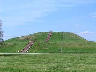
WMonks Mound is the largest Pre-Columbian earthwork in the Americas and the largest pyramid north of Mesoamerica. The beginning of its construction dates from 900–955 CE. Located at the Cahokia Mounds UNESCO World Heritage Site near Collinsville, Illinois, the mound size was calculated in 1988 as about 100 feet high, 955 feet long including the access ramp at the southern end, and 775 feet wide. This makes Monks Mound roughly the same size at its base as the Great Pyramid of Giza. The perimeter of its base is larger than the Pyramid of the Sun at Teotihuacan. As a platform mound, the earthwork supported a wooden structure on the summit.
WMound 34 is a small platform mound located roughly 400 metres (1,300 ft) to the east of Monks Mound at Cahokia Mounds near Collinsville, Illinois. Excavations near Mound 34 from 2002–2010 revealed the remains of a copper workshop, although the one of a kind discovery had been previously found in the late 1950s by archaeologist Gregory Perino, but lost for 60 years. It is so far the only remains of a copper workshop found at a Mississippian culture archaeological site.
WMound 72 is a small ridgetop mound located roughly 850 meters (2,790 ft) to the south of Monks Mound at Cahokia Mounds near Collinsville, Illinois. Early in the site's history, the location began as a circle of 48 large wooden posts known as a "woodhenge". The woodhenge was later dismantled and a series of mortuary houses, platform mounds, mass burials and eventually the ridgetop mound erected in its place. The mound was the location of the "beaded burial", an elaborate burial of an elite personage thought to have been one of the rulers of Cahokia, accompanied by the graves of several hundred retainers and sacrificial victims.
WThe Oak Forest Site (11Ck-53) is located in Oak Forest, Cook County, Illinois, near the city of Chicago. It is classified as a late Prehistoric to Protohistoric/Early Historic site with Upper Mississippian Huber affiliation.
WThe Palos site (Ck-26) is located on the Cal-Sag Canal in Cook County, Illinois, United States, near the city of Chicago. It is classified as a Protohistoric to early Historic site with Upper Mississippian affiliation.
 W
WThe Piasa or Piasa Bird is a Native American dragon depicted in one of two murals painted by Native Americans on bluffs (cliffsides) above the Mississippi River. Its original location was at the end of a chain of limestone bluffs in Madison County, Illinois at present-day Alton, Illinois. The original Piasa illustration no longer exists; a newer 20th-century version, based partly on 19th-century sketches and lithographs, has been placed on a bluff in Alton, Illinois, several hundred yards upstream from its origin. The location of the present-day mural is at 38.898055, -90.19915. The limestone rock quality on the new site is unsuited for holding an image, and the painting must be regularly restored. The original site of the painting was a high-quality layer of lithographic limestone, which was predominantly quarried away in the late 1870s by the Mississippi Lime Company.
 W
WThe Plum Island Site (Ls-2) is located in the Illinois River near Starved Rock, LaSalle County, Illinois, in the vicinity of the Hotel Plaza site and the Zimmerman site. It is a multi-component site representing Prehistoric, Protohistoric and early Historic periods, with the main occupation being a late Prehistoric to early Historic component with Upper Mississippian affiliation.