 W
WThe Northwest Indian War (1785–1795), also known as the Ohio War, Little Turtle's War, and by other names, was a war between the United States and the Western Confederacy, with support from the British, for control of the Northwest Territory. It followed centuries of conflict over this territory, first among Native American tribes, and then with the added shifting alliances among the tribes and the European powers of France and Great Britain, and their colonials. The United States Army considers it their first of the United States Indian Wars.
 W
WCampus Martius was a defensive fortification at the Marietta, Ohio settlement, and was home to Rufus Putnam, Benjamin Tupper, Arthur St. Clair, and other pioneers from the Ohio Company of Associates during the Northwest Indian War. Major Anselm Tupper was commander of the Campus Martius during the war. Construction began in 1788 and was fully completed in 1791. The Campus Martius was located on the east side of the Muskingum River, and upriver from its confluence with the Ohio River. A firsthand description of the fort is provided in Hildreth's Pioneer History, Campus Martius is the handsomest pile of buildings on this side of the Alleghany mountains, and in a few days will be the strongest fortification in the territory of the United States. It stands on the margin of the elevated plain on which are the remains of the ancient works [mounds], mentioned in my letter of May last, thirty feet above the high bank of the Muskingum, twenty-nine perches distant from the river, and two hundred and seventy-six from the Ohio. It consists of a regular square, having a block house at each angle, eighteen feet square on the ground, and two stories high; the upper story on the outside or face, jutting over the lower one, eighteen inches. These block houses serve as bastions to a regular fortification of four sides. The curtains are composed of dwelling houses two stories high, eighteen feet wide, and of different lengths.
 W
WThe Connecticut Western Reserve was a portion of land claimed by the Colony of Connecticut and later by the state of Connecticut in what is now mostly the northeastern region of Ohio. The Reserve had been granted to the Colony under the terms of its charter by King Charles II.
 W
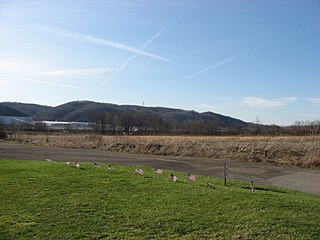
WThe Fallen Timbers Battlefield was the site of the Battle of Fallen Timbers on 20 August 1794. The battle, a decisive American victory over Native American and British opponents, effectively ended the Northwest Indian War, securing the Old Northwest for settlement. An area believed to be the battle site, located in Maumee, Ohio, was declared a National Historic Landmark in 1960. That site, now the Fallen Timbers State Memorial, is about 0.25 miles (0.40 km) south of the actual battlefield, which was identified in 1995, and much of which is now preserved as part of the Fallen Timbers Battlefield and Fort Miamis National Historic Site. The National Historic Site was established in 1999 as a partnership between the National Park Service, Toledo MetroParks, and the Ohio Historical Society.
 W
WFarmer's Castle was a defensive fortification built opposite the mouth of the Little Kanawha River on the Ohio River by a group of pioneers from the Ohio Company of Associates. It was located about 15 miles downriver of Marietta, Ohio, the first European-American settlement in the Northwest Territory. The pioneers had surveyed the land during the winter of 1788-89, and moved from Marietta to their new farms in April 1789. They called their town Belle-prairie, or modern day Belpre, Ohio. Adjacent to the island later known as Blennerhasset Island, the settlers began construction of Farmer's Castle during January 1791 for protection during the Northwest Indian War.The work was commenced the first week in January, and was prosecuted with the utmost energy, as their lives, apparently, depended on its completion. As fast as the block houses were built, the families moved into them. They were thirteen in number, arranged in two rows, with a wide street between, as shown in the engraving. The basement story was in general twenty feet square, and the upper about twenty-two feet, thus projecting over the lower one, and forming a defense from which to protect the doors and windows below, in an attack. They were built of round logs a foot in diameter, and the interstices nicely chinked and pointed with mortar. The doors and window shutters were made of thick oak planks, or puncheons, and secured with stout bars of wood on the inside. The larger timbers were hauled with ox-teams, of which they had several yokes, while the lighter for the roofs, gates, &c, were dragged along on hand sleds, with ropes, by the men. The drawing was much facilitated by a few inches of snow, which covered the ground. The pickets were made of quartered oak timber, growing on the plain back of the garrison, formed from trees about a foot in diameter, fourteen feet in length, and set four feet deep in the ground, leaving them ten feet high, over which no enemy could mount without a ladder. The smooth side was set outward, and the palisades strengthened and kept in their places by stout ribbons, or wall pieces, pinned to them with inch treenails on the inside. The spaces between the houses were filled up with pickets, and occupied three or four times the width of the houses, forming a continuous wall, or inclosure, about eighty rods in length and six rods wide. The palisades on the river side filled the whole space, and projected over the edge of the bank, leaning on rails and posts set to support them. They were sloped in this manner for the admission of air during the heat of summer.
 W
WThe First American Regiment was the first peacetime regular army infantry unit authorized by the Continental Congress after the American Revolutionary War. Organized in August 1784, it served primarily on the early American frontier beyond the Appalachian Mountains. In 1815, following the end of the War of 1812, it was consolidated with several other regiments to form the 3rd Infantry Regiment.
 W
WFort Defiance was built by General "Mad" Anthony Wayne in the second week of August 1794 at the confluence of the Auglaize and Maumee rivers. It was the one of a line of defenses constructed by American forces in the campaign leading to the Northwest Indian War's Battle of Fallen Timbers on August 20, 1794.
 W
WFort Frye was a triangular defensive fortification built by a group of pioneers from the Ohio Company of Associates who moved about twenty miles up the Muskingum River from the settlement of Marietta, Ohio to a location near the mouth of Wolf Creek. During 1789 the pioneers established settlements now known as Waterford and Beverly on the southwest and northeast banks of the Muskingum, respectively. The settlements were located about 13 miles downriver from a small group of pioneers at Big Bottom. During January and February 1791, following the massacre at Big Bottom and the start of the Northwest Indian War, the settlers built Fort Frye at Beverly. The form of the fort was triangular, which is rather uncommon in military defenses. But as they were in a hurry, and it saved them one line of curtains, while the block houses at the angles defended the sides just as well as in any other form, it was adopted. The base of the triangle rested on the river, distant only a few paces from the bank, and was about two hundred feet in length. One of the other sides was somewhat longer, so that the work was not a regular triangle. At each corner, was a two story block house, twenty feet square below, and a foot or two more above. The two longer sides were filled in with dwelling houses, some of which were two stories high, and others of a lesser height, while a considerable portion were built barrack fashion, with only one roof, pitched inward, so that the rain from it fell within the garrison. The spaces not occupied by buildings were filled in with stout pickets. Broad, substantial gates, near the northern block house, led out through the palisades into the highway and fields, while a smaller one in the curtain on the bank, called the water gate, afforded an opening to the river. A line of palisades, twelve feet high, at the distance of thirty feet, inclosed the whole, and descended to the river.
 W
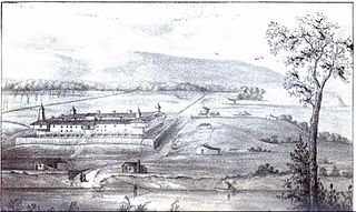
WFort Harmar was an early United States frontier military fort, built in pentagonal shape during 1785 at the confluence of the Ohio and Muskingum rivers, on the west side of the mouth of the Muskingum River. It was built under the orders of Colonel Josiah Harmar, then commander of the United States Army, and took his name. The fort was intended for the protection of Indians, i.e., to prevent pioneer squatters from settling in the land to the northwest of the Ohio River. "The position was judiciously chosen, as it commanded not only the mouth of the Muskingum, but swept the waters of the Ohio, from a curve in the river for a considerable distance both above and below the fort." It was the first frontier fort built in Ohio Country.
 W
WFort Jefferson was a fortification erected by soldiers of the United States Army in Oct. 1791 during the Northwest Indian War. Built to support a military campaign, it saw several years of active fighting. Today, the fort site is a historic site.
 W
WFort McIntosh was an early American log frontier fort situated near the confluence of the Ohio River and the Beaver River in what is now Beaver, Pennsylvania.
 W
WFort Miami (Miamis) was a British fort built in spring 1794 on the Maumee River in what was at the time territory of the United States, and designated by the federal government as the Northwest Territory. The fort was located at the eastern edge of present-day Maumee, Ohio, southwest of Toledo. The British built the fort to forestall a putative assault on Fort Detroit by Gen. "Mad" Anthony Wayne's army, then advancing northward in southwestern Ohio
 W
WFort Miami, originally called Fort St. Philippe or Fort des Miamis, was the name of a pair of French palisade forts built at Kekionga, a large Miami Indian village founded where the St. Joseph River and St. Marys River merge to form the Maumee River in northeastern Indiana, near the Ohio border.
 W
WFort Recovery was a United States Army fort ordered built by General "Mad" Anthony Wayne during what is now termed the Northwest Indian War. Constructed from late 1793 and completed in March 1794, the fort was built along the Wabash River, within two miles of what became the Ohio state border with Indiana. A detachment of Wayne's Legion of the United States held off an attack from combined Indian forces on June 30, 1794. The fort was used as a reference in drawing treaty lines for the 1795 Treaty of Greenville, and for later settlement. The fort was abandoned in 1796.
 W
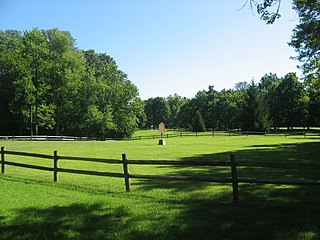
WFort St. Clair was a fort built during the Northwest Indian War near the modern town of Eaton, Preble County, Ohio. The site of the fort was listed on the National Register of Historic Places in 1970.
 W
WFort Washington was a fortified stockade with blockhouses built by order of Gen. Josiah Harmar starting in summer 1789 in what is now downtown Cincinnati, Ohio near the Ohio River. The physical location of the fort was facing the mouth of the Licking River, above present day Fort Washington Way. The fort was named in honor of President George Washington. The Fort was the major staging place and conduit for settlers, troops and supplies during the conquest and settlement of the Northwest Territory.
 W
WFort Wayne, situated on a portion of what is now Fort Wayne, Indiana, was a series of three successive military log stockades (forts) existing between 1794 and 1819 in the Miami Indian village of Kekionga on the portage between the St. Mary's and St. Joseph Rivers in northeastern Indiana near the Ohio border. The first fort with that name was built in 1794 by Captain Jean François Hamtramck under orders from General "Mad" Anthony Wayne as part of the campaign against the Miami Indians during the Northwest Indian War. It was named after General Wayne, who was victorious at the just prior Battle of Fallen Timbers. Wayne may have chosen the name himself—the fort was dedicated the day after he left it. The fort was officially occupied by the army on October 21, 1794. The fort was a basic stockade with few buildings, and was located near the present intersection of Berry and Clay streets.
 W
WThe Treaty of Fort Harmar (1789) was an agreement between the United States government and numerous Native American tribes with claims to the Northwest Territory.
 W
WThe Treaty of Amity, Commerce, and Navigation, Between His Britannic Majesty and the United States of America, commonly known as the Jay Treaty, and also as Jay's Treaty, was a 1795 treaty between the United States and Great Britain that averted war, resolved issues remaining since the Treaty of Paris of 1783, and facilitated ten years of peaceful trade between the United States and Britain in the midst of the French Revolutionary Wars, which began in 1792. The Treaty was designed by Alexander Hamilton and supported by President George Washington. It angered France and bitterly divided Americans. It inflamed the new growth of two opposing parties in every state, the pro-Treaty Federalists and the anti-Treaty Jeffersonian Republicans.
 W
WThe Legion of the United States was a reorganization and extension of the Continental Army from 1792 to 1796 under the command of Major General Anthony Wayne. It represented a political shift in the new United States, which had recently adopted the United States Constitution. The new Congressional and Executive branches authorized a standing army composed of professional soldiers, rather than relying on state militias.
 W
WLegionville was the first formal basic training facility for the military of the United States. The camp, which was established in winter 1792 under the command of Major General Anthony Wayne, was near present-day Baden, Pennsylvania, a suburb of Pittsburgh. It was used to train the soldiers which would become the Legion of the United States.
 W
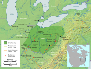
WThe Ohio Country was a name used in the mid- to late 18th century for a region of North America west of the Appalachian Mountains and north of the upper Ohio and Allegheny Rivers extending to Lake Erie. The area encompassed roughly all of present-day states of Ohio, northwestern West Virginia, Western Pennsylvania, and a wedge of southeastern Indiana.
 W
WPicketed Point Stockade was the last of three fortifications built at Marietta, Ohio. This defensive stockade was built by pioneers during the Northwest Indian War in 1791 on the east side of the mouth of the Muskingum River at its confluence with the Ohio River, and directly across the Muskingum from Fort Harmar. Colonel William Stacy superintended the construction of the stockade under direction of Colonel Ebenezer Sproat. Palisades or pickets were set from the Muskingum River eastward, meeting in the northeast corner of the fortification with another line of pickets built from the Ohio River northward, enclosing about four acres. Three block houses were immediately built: one on the Muskingum bank, at the western termination of the pickets; one in the northeast corner of the inclosure; and one on the Ohio bank. Near to the latter, and by that on the Muskingum, were strong gates, of a size to admit teams, the approaches to which were commanded by the block houses. These block houses were surmounted by sentry boxes, or turrets, the sides of which were secured with thick planks for the defense of the men when on guard.
 W
WThe Treaty of Fort Stanwix was a treaty finalized on October 22, 1784, between the United States and Native Americans from the six nations of the Iroquois League. It was signed at Fort Stanwix, in present-day Rome, New York, and was the first of several treaties between Native Americans and the United States after the American victory in the Revolutionary War.
 W
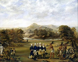
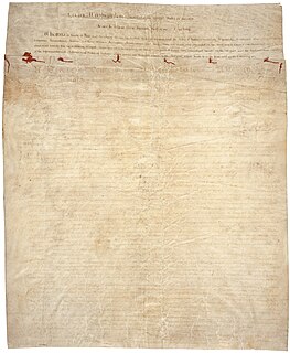
WThe Treaty of Greenville, formally titled Treaty with the Wyandots, etc., was a 1795 treaty between the United States and indigenous nations of the Northwest Territory including the Wyandot and Delaware peoples, which redefined the boundary between indigenous peoples' lands and territory for European American settlement.
 W
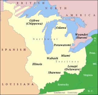
WThe Western Confederacy, or Western Indian Confederacy, was a loose confederacy of Native Americans in the Great Lakes region of the United States created following the American Revolutionary War. Formally, the confederacy referred to itself as the United Indian Nations, at their Confederate Council. It is also known as the Miami Confederacy, since many contemporaneous federal officials overestimated the influence and numerical strength of the Miami tribes based on the size of their principle city, Kekionga. The confederacy, which had its roots in pan-tribal movements dating to the 1740s, formed in an attempt to resist the expansion of the United States and the encroachment of American settlers into the Northwest Territory after Great Britain ceded the region to the U.S. in the 1783 Treaty of Paris. This resulted in the Northwest Indian War (1785–1795), in which the Confederacy won significant victories over the United States, but concluded with an U.S. victory at the Battle of Fallen Timbers. The Confederacy became fractured and agreed to peace with the United States, but the pan-tribal resistance was later rekindled by Tenskwatawa and his brother, Tecumseh.