 W
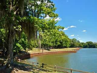
WThe Beaverdam Creek Archaeological Site,, is an archaeological site located on a floodplain of Beaverdam Creek in Elbert County, Georgia approximately 0.8 km from the creek's confluence with the Savannah River, and is currently inundated by the Richard B. Russell Lake. The site consisted of a platform mound and an associated village site. Beaverdam Creek is thought to have been the center of a Mississippian culture simple chiefdom with a small resident population. The primary period of mound construction and village occupation dated to the regional Savannah period of the Middle Mississippian period, specifically 1200–1300 CE, with the site's abandonment occurring sometime after 1300. The mound was 1.5 metres (4.9 ft) high, and its base measured 25 metres (82 ft) by 25 metres (82 ft). The village boundaries were delineated as 15,000 square meters.
WBell Field Mound Site is an archaeological site located on the western bank of the Coosawattee River below the Coosawatee’s junction with Talking Rock Creek. The site itself was destroyed by the construction of Carters Dam in the 1970s. With respect to the dam itself, Bell Field was located in front of the high dam along with the Sixtoe Mound and Little Egypt sites.
 W
WChickamauga and Chattanooga National Military Park, located in northern Georgia and southeastern Tennessee, preserves the sites of two major battles of the American Civil War: the Battle of Chickamauga and the Siege of Chattanooga. A detailed history of the park's development was provided by the National Park Service in 1998.
WThe Dyar site (9GE5) is an archaeological site in Greene County, Georgia, in the north central Piedmont physiographical region. The site covers an area of 2.5 hectares. It was inhabited almost continuously from 1100 to 1600 by a local variation of the Mississippian culture known as the South Appalachian Mississippian culture. Although submerged under Lake Oconee, the site is still important as one of the first explorations of a large Mississippian culture mound. The Dyar site is thought to have been one of the principal towns of the paramount chiefdom of Ocute, perhaps Cofaqui.
 W
WEtowah Indian Mounds (9BR1) are a 54-acre (220,000 m2) archaeological site in Bartow County, Georgia south of Cartersville, in the United States. Built and occupied in three phases, from 1000–1550 AD, the prehistoric site is located on the north shore of the Etowah River. Etowah Indian Mounds Historic Site is a designated National Historic Landmark, managed by the Georgia Department of Natural Resources. It is considered "the most intact Mississippian culture site in the Southeastia ", according to the Georgia State Parks and Historic Sites. It is revered as sacred by the Muscogee Creek and Cherokee peoples, who both occupied this area at varying times.
 W
WFort Daniel was a fort in Georgia, United States. Located on Hog Mountain in modern-day Gwinnett County, the fort was built in 1813, during the War of 1812, to protect settlers in the state's western regions from attacks. The site of the fort underwent archaeological excavation in 2007.
WFort Frederica National Monument, on St. Simons Island, Georgia, preserves the archaeological remnants of a fort and town built by James Oglethorpe between 1736 and 1748 to protect the southern boundary of the British colony of Georgia from Spanish raids. About 630 British troops were stationed at the fort.
WThe Fort Gaines Cemetery Site is a prehistoric mound, an archeological site, within the Fort Gaines Cemetery in Fort Gaines, Georgia.
WThe Joe Bell Site (9MG28) is an archaeological site located in Morgan County, Georgia underneath Lake Oconee, but prior to the 1970s, it was located south of the mouth of the Apalachee River on the western bank of the Oconee River. The junction of these two rivers could be seen from the site. This site was first visited by Marshall Williams in 1968 at the suggestion of the site’s landowner, Joe Bell, who had discovered various artifacts while the site was being regularly plowed. Because of Interstate construction, Marshall Williams and Mark Williams discovered this site during surface surveys and excavations of the plowed areas. The site was excavated and analyzed by Mark Williams as part of his PhD dissertation. During the 1969 excavations, four areas within the site were designated for excavation. In Areas 1-3 various five foot square units were excavated. No excavations were done in Area 4 in 1969. Large quantities of small potsherds were discovered during these excavations, and they ranged from the Duvall Phase in Area 1 to Bell Phase in Areas 2-4. As part of the 1969 excavations, a road grading machine took off the topsoil of twelve strips on the site. This uncovered Features 1 and 2, and they were completely excavated. In 1977, the site was revisited by Marshall Williams and Mark Williams. Since various plans threatened this site, major excavations took place from June 15, 1977 until September 16, 1977 by Mark Williams. Most of the work centered on Area 2 or the Bell Phase portion of the site. The Bell Phase portion of this site was probably no more the 1.5 acres (1 ha). Because of time constraints, only 17 of 55 features were excavated, and no more than a handful of the 1100 posts were excavated. A few trips were made back to the site the following year with the help of volunteers, and approximately 80% of the area stripped by heavy machinery was mapped. Some of the features were trash features that consisted of a circular pit filled with food residues and pottery sherds. Evidence of a large circular structure or rotunda was found at the site. It was the social, political, and religious center for the inhabitants. A large quantity of the features was small, circular, semi-subterranean structures that were probably used as sleeping quarters on cold nights. Another structure found was warm weather structures. One major trash feature was found that had been deposited in a single episode and was burned during or after deposition. Numerous sherds were found in this pit, and many reconstructable vessels were present. Ethnohistoric literature of the Southeast suggests that this feature was formed during a Busk or Green Corn ceremony. The ceremony has been described as the physical cleansing of the town.
WThe Kenimer Site is an archaeological site near Sautee Nacoochee, Georgia in White County. The site contains two earthwork mounds located on top of a natural hilltop.
 W
WThe King Archaeological Site (9FL5) is a protohistoric Native American archaeological site located on the Coosa River in Floyd County, Georgia. It is one of 5 large contemporaneous village sites located in a 20 kilometres (12 mi) section of the river. The site was a satellite village associated with the Coosa chiefdom centered on the Little Egypt Site located upstream.
 W
WThe Kolomoki Mounds is one of the largest and earliest Woodland period earthwork mound complexes in the Southeastern United States and is the largest in Georgia. Constructed from 350CE to 600CE, the mound complex is located in southwest Georgia, in present-day Early County near the Chattahoochee River.
WThe Lamar Mounds and Village Site (9BI2) is an important archaeological site on the banks of the Ocmulgee River in Bibb County, Georgia and several miles to the southeast of the Ocmulgee Mound Site. Both mound sites are part of the Ocmulgee National Monument, a national park and historic district created in 1936 and run by the U.S. National Park Service. Historians and archaeologists have theorized that the site is the location of the main village of the Ichisi encountered by the Hernando de Soto expedition in 1539.
 W
WLeake Mounds (9BR2) is an important archaeological site in Bartow County, Georgia built and used by peoples of the Swift Creek Culture. The site is 2 miles (3.2 km) west of Etowah Mounds on the Etowah River, although it predates that site by hundreds of years. Excavation of nearly 50,000 square feet (4,600 m2) on the site showed that Leake Mounds was one of the most important Middle Woodland period site in this area from around 300 BCE to 650 CE, a center with ties throughout the Southeast and Midwest. It was abandoned about 650 CE and not occupied again until by different peoples near the end of the Mississippian culture period, about 1500.
WThe Little Egypt site was an archaeological site located in Murray County, Georgia, near the junction of the Coosawattee River and Talking Rock Creek. The site originally had three platform mounds surrounding a plaza and a large village area. It was destroyed during the construction of the Dam of Carters Lake in 1972. It was situated between the Ridge and Valley and Piedmont sections of the state in a flood plain. Using Mississippian culture pottery found at the site archaeologists dated the site to the Middle and Late South Appalachian culture habitation from 1300 to 1600 CE during the Dallas, Lamar, and Mouse Creek phases.
WThe Little Mulberry Indian Mounds are a series of carefully stacked rock piles located in Little Mulberry Park, Dacula, Georgia. In 1990, architect Michael Garrow counted 200 of these stone mounds while surveying the land ahead of a proposed golf course residential development. The stone piles are typically circular or semicircular in shape. Most of those that have been examined archaeologically have revealed no cultural artifacts beyond the stone structure, while a few have been found to have historical 19th-century artifacts underneath them.
WLong Swamp Site is a 4-acre (16,000 m2) archaeological site in Cherokee County, Georgia on the north shore of the Etowah River near St Rt 372. The site consists of a South Appalachian Mississippian culture village with a palisade and a platform mound.
WThe Mandeville Site (9CY1) is an archaeological site in Clay County in southwest Georgia in the United States. The site now lies under the Walter F. George Reservoir, which is a part of the Chattahoochee River basin.
 W
WThe Nacoochee Mound is an archaeological site on the banks of the Chattahoochee River in White County, in the northeast part of the U.S. state of Georgia, at the junction of Georgia State Route 17 and Georgia State Route 75. First occupied as early as 100-500 CE, the site was later developed and occupied more intensively by peoples of the South Appalachian Mississippian culture from 1350 to 1600 CE. One of their characteristic platform mounds is located at the site. A professional archeological excavation revealed a total of 75 human burials, with artifacts that support dating of the site.
WOcmulgee Mounds National Historical Park in present-day Macon, Georgia, United States preserves traces of over ten millennia of culture from the Native Americans in the Southeastern Woodlands. Its chief remains are major earthworks built before 1000 CE by the South Appalachian Mississippian culture These include the Great Temple and other ceremonial mounds, a burial mound, and defensive trenches. They represented highly skilled engineering techniques and soil knowledge, and the organization of many laborers. The site has evidence of "17,000 years of continuous human habitation." The 702-acre (2.84 km2) park is located on the east bank of the Ocmulgee River. Present-day Macon, Georgia developed around the site after the United States built Fort Benjamin Hawkins nearby in 1806 to support trading with Native Americans.
WThe Punk Rock Shelter (9PM211) was an archaeological site found in Putnam County, Georgia. The site flooded in 1979, putting it 65 feet (20 m) under Lake Oconee. It was not a rock shelter, but a jumble of granite boulders or tors. These tors happened to create a shelter-like area. Due to poor land management in the 19th and 20th century associated with cotton farming, the shelter floor area is now underneath at least a meter deep of red clay and silt mud. The Native Americans at the site were most likely Hitchiti in ancestry.
WThe Rembert Mounds (9EB1) is an archaeological site in Elbert County, Georgia in the area that is now under the Clark Hill Reservoir on the Savannah River. The last excavation of the site occurred just before the reservoir was built; Joe Caldwell and Carl F. Miller conducted the excavation during a three-week period between January 12 and June 1, 1948. However, they are not the first people to examine the site. William Bartram first described the mounds in 1773 as: "an imposing group of one large and several smaller mounds standing adjacent to some extensive structures [which he called tetragon terraces]." In 1848, George White claimed "the smaller mounds had been nearly destroyed." Then, Charles C. Jones, Jr. stated that "only traces of the smaller mounds remained and the tetragon terraces were no more than gentle elevations." Less than 10 years later, in 1886, John P. Rogan excavated part of the site under Cyrus Thomas and found only the largest mound and one of the smaller mounds still standing. Rogan's excavation was the last before Caldwell and Miller's excavation in 1948. However, there was a flood in 1908 that almost completely destroyed the large mound.
 W
WRock Eagle Effigy Mound is an archaeological site in Putnam County, Georgia, U.S. estimated to have been constructed c. 1000 BC to AD 1000. The earthwork was built up of thousands of pieces of quartzite laid in the mounded shape of a large bird. Although it is most often referred to as an eagle, scholars do not know exactly what type of bird the original builders intended to portray. It is listed on the National Register of Historic Places (NRHP) because of its significance. The University of Georgia administers the site. It uses much of the adjoining land for a 4-H camp, with cottages and other buildings, and day and residential environmental education.
 W
WThe Roods Landing Site or Roods Creek Mounds (9SW1) is an archaeological site located south of Omaha, Stewart County, Georgia, United States at the confluence of Rood Creek and the Chattahoochee River. It is a Middle Woodland / Mississippian period Pre-Columbian complex of earthen mounds. It was entered on the National Register of Historic Places on August 19, 1975.
WThe Sixtoe Mound site (9MU100) is an archaeological site in Murray County, Georgia excavated by Arthur Randolph Kelly from 1962-1965 as a part of the Carters Dam project conducted for the National Park Service by the University of Georgia. The site consisted of a low platform mound and an associated village. The majority of the mound was excavated, while the village received little excavation.
WStallings Island is an archeological site with shell mounds, located in the Savannah River near Augusta, Georgia. The site is the namesake for the Stallings culture of the Late Archaic period and for Stallings fiber-tempered pottery, the oldest known pottery in North America. The site was declared a National Historic Landmark in 1961.
 W
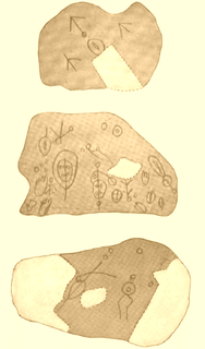
WTrack Rock is located in the Track Rock Gap Archaeological Area (9Un367) in the Brasstown Ranger District of the Chattahoochee National Forest in Georgia. This 52-acre (210,000 m2) area contains preserved petroglyphs of ancient Native American origin that resemble animal and bird tracks, crosses, circles and human footprints. Track Rock is explained by the Georgia Historical Marker placed there in 1988: This area is one of the best-known of the petroglyph, or marked stone, sites in Georgia. The six table-sized soapstone boulders contain hundreds of symbols carved or pecked into their surface. Archaeologists have speculated dates for the figures from the Archaic Period to the Cherokee Indians who lived here until the 19th Century. No one knows the exact meaning of the symbols or glyphs which represent animals, birds, tracks and geometric figures. The earliest written account (1834) was by Dr. Matthew Stephenson, who was director of the U.S. Branch Mint in Dahlonega. One of the favorite stories about Track Rock Gap was recorded by ethnographer James Mooney who gathered Cherokee stories. The Cherokee called this site Datsu'nalasgun'ylu and Degayelun'ha. Cherokee stories include an explanation that hunters paused in the gap and amused themselves by carving the glyphs: the marks were made in a great hunt when the animals were driven through the gap, and that the tracks were made when the animals were leaving the great canoe after a flood almost destroyed the world and while the earth and rocks were soft.