 W
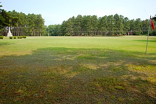
WAlamance Battleground is a North Carolina State Historic Site commemorating the Battle of Alamance. The historic site is located south of Burlington, Alamance County, North Carolina in the United States.
 W
WThe Battle of Alamance, which took place on May 16, 1771, was the final battle of the War of the Regulation, a rebellion in colonial North Carolina over issues of taxation and local control, considered by some to be the opening salvo of the American Revolution. Named for nearby Great Alamance Creek, the battle took place in what was then Orange County and has since become Alamance County in the central Piedmont area, about 6 miles (9.7 km) south of present-day Burlington, North Carolina.
 W
WAlbemarle County, established in 1664, is a former county located in the U.S. state of North Carolina. It contained what is now the northeastern portion of North Carolina.
 W
WThe Albemarle Settlements were the first permanent English settlements in what is now North Carolina, founded in the Albemarle Sound and Roanoke River regions, beginning about the middle of the 17th century. The settlers were mainly Virginians migrating south.
 W
WBath County is an extinct county formerly located in the British American colony of North Carolina. The county was established in 1696 and was abolished in 1739. The original three precincts of Bath County—Pamplicough, Wyckham and Archdale—were renamed in 1712 and became Beaufort, Hyde, and Craven counties when Bath County split in 1738.
 W
WThe Cane Creek Friends Meeting, founded in 1751, is considered the first established Quaker community in the Piedmont region of North Carolina. The site was occupied by British troops during the American Revolutionary War.
 W
WThe early province of Carolana was the land forming the southern English colonies, spanning from 31° to 36° north latitude. In 1629, King Charles I of England granted the territory to his attorney general Sir Robert Heath. The original charter claimed the land from Albemarle Sound in present-day North Carolina, to the St. Johns River in the south, just miles below the current Florida-Georgia state line. The region as a whole comprised the modern day states of Louisiana, Florida, Georgia, Alabama, and North and South Carolina. Charles I named the colony for himself, the name Carolana derives from Carolus, the Latin form of Charles.
 W
WCataloochee is a valley in the Great Smoky Mountains of North Carolina, located in the Southeastern United States. Now a recreational and historic area within the Great Smoky Mountains National Park, Cataloochee was once home to a substantial Appalachian community and Cherokee hunting ground.
 W
WThe Cherokee Nation was a legal, autonomous, tribal government in North America recognized from 1794 to 1907. It was often referred to simply as "The Nation" by its inhabitants. The government was disbanded in 1907, after its land rights had been extinguished, prior to the admission of Oklahoma as a state. During the late 20th century, the Cherokee people reorganized, instituting a government with sovereign jurisdiction known as the Cherokee Nation.
 W
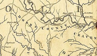
WDobbs County is a former county located in the Province of North Carolina and later the state of North Carolina. It was formed in 1758 from Johnston County, though the legislative act that created it did not become effective until April 10, 1759. It was named for Arthur Dobbs, Governor of the Province of North Carolina from 1754 to 1765.
 W
WFort San Juan was a late 16th-century fort built by the Spanish under the command of conquistador Juan Pardo in the native village of Joara, in what is now Burke County, North Carolina. Used as an outpost for Pardo's expedition into the interior of what was known to the Spaniards as "la Florida", Fort San Juan was the foremost of six forts built and garrisoned by Pardo in modern-day North Carolina, South Carolina, and Tennessee to extend Spain's effective control deeper into the North American continent.
 W
WThe Fundamental Constitutions of Carolina were adopted on March 1, 1669 by the eight Lords Proprietors of the Province of Carolina, which included most of the land between what is now Virginia and Florida. It replaced the Charter of Carolina and the Concessions and Agreements of the Lords Proprietors of the Province of Carolina (1665). The date March 1, 1669 was the date that proprietors confirmed the Constitutions and sent them to the Colony, but later on two other versions were introduced in 1682 and in 1698. Moreover, the proprietors suspended the Constitutions in 1690. Despite the claims of proprietors on the valid version of the Constitution, the colonists officially recognized the July 21, 1669 version, claiming that six proprietors had sealed the Constitutions as "the unalterable form and rule of Government forever" on that date. The earliest draft of this version in manuscript is believed to be the one found at Columbia, South Carolina archives.
 W
WThe Grand Model was a utopian plan for the Province of Carolina, founded in 1670. It consisted of a constitution coupled with a settlement and development plan for the colony. The former was titled the Fundamental Constitutions of Carolina. The word "constitutions" was synonymous with "articles." The document was composed of 120 constitutions, or articles. The settlement and development plan for the colony consisted of several documents, or "instructions," for guiding town and regional planning as well as economic development.
 W
WThe Granville District was an approximately 60-mile wide strip of land in the North Carolina colony adjoining the boundary with the Province of Virginia, lying between north latitudes 35° 34' and 36° 30'. From 1663 until 1779, the District was held under control of the descendants of Sir George Carteret, one of the original Lords Proprietor of the Province of Carolina. After 1729, the Granville District's land allotment totaled nearly half of the land in North Carolina.
 W
WJoara was a large Native American settlement, a regional chiefdom of the Mississippian culture, located in what is now Burke County, North Carolina, about 300 miles from the Atlantic coast in the foothills of the Blue Ridge Mountains. Joara is notable as a significant archaeological and historic site, where Mississippian and European artifacts have been found, in addition to an earthwork mound and remains of a 16th-century Spanish fort.
 W
WThe North Carolina pound, commonly known as the pound, was the currency of North Carolina until 1793. Initially, the British pound circulated, supplemented from 1709 by local paper money and the introduction of Colonial currency and the Pound denominations in 1712. Although these notes were denominated in pounds, shillings and pence, they were worth less than sterling, with 1 North Carolina shilling = 9 pence sterling. The first issue of paper money was known as "Old Tenor" money. In 1748, "New Tenor" paper money was introduced, worth 7½ times the Old Tenor notes.
 W
WThe Province of North Carolina was a British colony that existed in North America from 1712 to 1776, created as a proprietary colony. The power of the British government was vested in a governor of North Carolina, but the colony declared independence from Great Britain in 1776. The Province of North Carolina had four capitals: Bath (1712–1722), Edenton (1722–1743), Brunswick (1743–1770), and New Bern. The colony later became the states of North Carolina and Tennessee, and parts of the colony combined with other territory to form the states of Georgia, Alabama, and Mississippi.
 W
WOconaluftee is a river valley in the Great Smoky Mountains of North Carolina, located in the Southeastern United States. Formerly the site of a Cherokee village and Appalachian community, the valley's bottomland is now home to the main entrance to the North Carolina side of the Great Smoky Mountains National Park.
 W
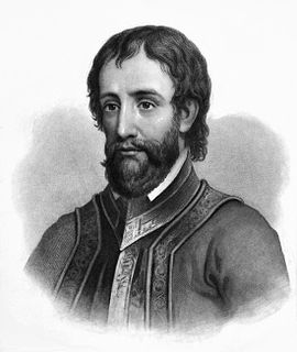
WJuan Pardo was a Spanish explorer who was active in the later half of the sixteenth century. He led a Spanish expedition through what is now North and South Carolina and into eastern Tennessee on the orders of Pedro Menéndez de Avilés, who had built Fort San Felipe (1566), and established Santa Elena, on present-day Parris Island; these were the first Spanish settlements in what is now South Carolina. While leading an expedition deeper in-country, Pardo founded Fort San Juan at Joara, the first European settlement (1567–1568) in the interior of North Carolina.
 W
WThe Province of Carolina was an English and later a British colony of North America. Carolina was founded in what is present-day North Carolina. Carolina expanded south and, at its greatest extent, nominally included the present-day states of North Carolina, South Carolina, Georgia, Alabama, Tennessee and Mississippi.
 W
WThe Roanoke Colony refers to two attempts by Sir Walter Raleigh to found the first permanent English settlement in North America. The English, led by Humphrey Gilbert, had claimed St. John's, Newfoundland, in 1583 as the first North American English colony by royal prerogative of Queen Elizabeth I. Roanoke was second. The first Roanoke colony was established by governor Ralph Lane in 1585 on Roanoke Island in what is now Dare County, North Carolina, United States. Following the failure of the 1585 settlement, a second colony led by John White landed on the same island in 1587, and became known as the Lost Colony due to the unexplained disappearance of its population.
 W
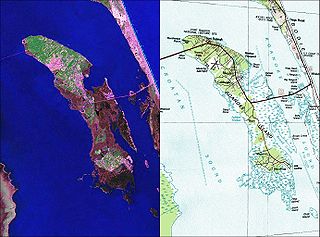
WRoanoke Island is an island in Dare County on the Outer Banks of North Carolina, United States. It was named after the historical Roanoke Carolina Algonquian people who inhabited the area in the 16th century at the time of English exploration.
 W
WThe Royal Colonial Boundary of 1665 marked the border between the Colony of Virginia and the Province of Carolina from the Atlantic Ocean westward across North America. The line follows the parallel 36°30′ north latitude that later became a boundary for several U.S. states as far west as the Oklahoma Panhandle, and also came to be associated with the Missouri Compromise of 1820.
 W
WHernando de Soto was a Spanish explorer and conquistador who was involved in expeditions in Nicaragua and the Yucatan Peninsula, and played an important role in Pizarro's conquest of the Inca Empire in Peru, but is best known for leading the first European expedition deep into the territory of the modern-day United States. He is the first European documented as having crossed the Mississippi River.
 W
WThe Spanish missions in the Carolinas were part of a series of religious outposts established by Spanish Catholics in order to spread the Christian doctrine among the local Native Americans. Spanish missions extended north almost to the site of present-day Charleston, and they remained until the arrival of the English (1670).
 W
WThe War of the Regulation, also known as the Regulator movement, was an uprising in British America's Carolina colonies, lasting from around 1765 to 1771, in which citizens took up arms against colonial officials, whom they viewed as corrupt. Though the rebellion did not change the power structure, some historians consider it a catalyst to the American Revolutionary War. Others like John Spencer Bassett take the view that the Regulators did not wish to change the form or principle of their government, but simply wanted to make the colony's political process more equal. They wanted better economic conditions for everyone, instead of a system that heavily benefited the colonial officials and their network of plantation owners mainly near the coast. Bassett interprets the events of the late 1760s in Orange and surrounding counties as "...a peasants' rising, a popular upheaval."
 W
WThe Watauga Association was a semi-autonomous government created in 1772 by frontier settlers living along the Watauga River in what is now Elizabethton, Tennessee. Although it lasted only a few years, the Watauga Association provided a basis for what later developed into the state of Tennessee and likely influenced other western frontier governments in the trans-Appalachian region. North Carolina annexed the Watauga settlement area, by then known as the Washington District, in November 1776. Within a year, the area was placed under a county government, becoming Washington County, North Carolina, in November 1777. This area covers the present day Washington County, Carter County, and other areas now located in the northeast part of the state of Tennessee.
 W
WYates Mill is a fully restored, circa 1756 gristmill located five miles (8 km) south of downtown Raleigh, North Carolina, United States. It is the centerpiece of Historic Yates Mill County Park, in central Wake County. The park features the restored mill; a visitor center with a museum focused on milling and on the natural history of the area, classrooms, an auditorium and space for research conducted by North Carolina State University faculty and students; a 20-acre (81,000 m2) lake; and extensive hiking trails. The park is managed as a native wildlife refuge with a mission to study and interpret the park's cultural, natural and agricultural heritage.