 W
WThe Maya civilization was a Mesoamerican civilization developed by the Maya peoples, and noted for its logosyllabic script—the most sophisticated and highly developed writing system in pre-Columbian Americas—as well as for its art, architecture, mathematics, calendar, and astronomical system. The Maya civilization developed in an area that encompasses southeastern Mexico, all of Guatemala and Belize, and the western portions of Honduras and El Salvador. This region consists of the northern lowlands encompassing the Yucatán Peninsula, and the highlands of the Sierra Madre, running from the Mexican state of Chiapas, across southern Guatemala and onwards into El Salvador, and the southern lowlands of the Pacific littoral plain. The overarching term "Maya" is a modern collective term that refers to the peoples of the region, however, the term was not used by the indigenous populations themselves since there never was a common sense of identity or political unity among the distinct populations. Today, the Maya peoples number well over 6 million people, speaking over twenty-eight surviving Mayan languages and residing in nearly the same area as their ancestors.
 W
WAncient Maya graffiti are a poorly studied area of folk art of the pre-Columbian Maya civilization. Graffiti were incised into the stucco of interior walls, floors, and benches, in a wide variety of buildings, including pyramid-temples, residences, and storerooms. Graffiti have been recorded at over 50 Maya sites, particularly clustered in the Petén Basin and southern Campeche, and the Chenes region of northwestern Yucatán. At Tikal, where a great quantity of graffiti have been recorded, the subject matter includes drawings of temples, people, deities, animals, banners, litters, and thrones. Graffiti were often inscribed haphazardly, with drawings overlapping each other, and display a mix of crude, untrained art, and examples by artists who were familiar with Classic-period artistic conventions.
 W
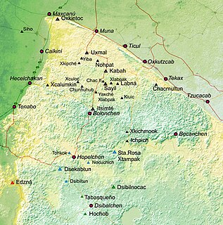
WBolonchén or Bolonchén de Rejón is a town in the Mexican state of Campeche, about 120 km East from the state capital, Campeche, in Hopelchén Municipality. As of 2010 the town had a population of 3,975 people. A short distance to the south of Bolonchén are located the caves of Xtacunbilxunan.
 W
WBonampak is an ancient Maya archaeological site in the Mexican state of Chiapas. The site is approximately 30 km (19 mi) south of the larger site of Yaxchilan, under which Bonampak was a dependency, and the border with Guatemala. While the site is not overly impressive in terms of spatial or architectural size, it is well known for the murals located within the three roomed Structure 1. The construction of the site's structures dates to the Late Classic period. In addition to being among the best-preserved Maya murals, the Bonampak murals are noteworthy for debunking early assumptions that the Maya were a peaceful culture of mystics, as the murals clearly depict war and human sacrifice.
 W
WClassic Maya is the oldest historically attested member of the Mayan language family. It is the main language documented in the pre-Columbian inscriptions of the Classic Era Maya civilization.
 W
WCalakmul is a Maya archaeological site in the Mexican state of Campeche, deep in the jungles of the greater Petén Basin region. It is 35 kilometres (22 mi) from the Guatemalan border. Calakmul was one of the largest and most powerful ancient cities ever uncovered in the Maya lowlands.
 W
WCaracol is the name given to a large ancient Maya archaeological site, located in what is now the Cayo District of Belize. It is situated approximately 40 kilometres south of Xunantunich and the town of San Ignacio Cayo, and 15 kilometers away from the Macal River. It rests on the Vaca Plateau at an elevation of 500 meters above sea-level, in the foothills of the Maya Mountains. Long thought to be a tertiary center, it is now known that the site was one of the most important regional political centers of the Maya Lowlands during the Classic Period. Caracol covered approximately 200 square kilometers, covering an area much larger than present-day Belize City and supported more than twice the modern city's population.
 W
WChactún is the name of an archaeological site of the Mesoamerican Maya civilization in the state of Campeche, Mexico, in the northern part of the Calakmul Biosphere Reserve. The site of approximately 54 acres is located in the lowlands of the Yucatán Peninsula, between the regions of Rio Bec and Chenes. There are some significant differences that have yet to be explained completely, which distinguish it from some of the other nearby sites.
 W
WCoba is an ancient Mayan city on the Yucatán Peninsula, located in the Mexican state of Quintana Roo. The site is the nexus of the largest network of stone causeways of the ancient Mayan world, and it contains many engraved and sculpted stelae that document ceremonial life and important events of the Late Classic Period of Mesoamerican civilization. The adjacent modern village bearing the same name, reported a population of 1,278 inhabitants in the 2010 Mexican federal census.
 W
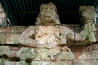
WCopán is an archaeological site of the Maya civilization in the Copán Department of western Honduras, not far from the border with Guatemala. This ancient Maya city mirrors the beauty of the physical landscape in which it flourished—a fertile, well-watered mountain valley in western Honduras at an elevation of 600 meters above mean sea level. It was the capital city of a major Classic period kingdom from the 5th to 9th centuries AD. The city was in the extreme southeast of the Mesoamerican cultural region, on the frontier with the Isthmo-Colombian cultural region, and was almost surrounded by non-Maya peoples.
 W
WEl Rey is an archaeological site of the pre-Columbian Mayan culture, located in the southeast of Mexico, in the tourist resort of Cancun, in the state of Quintana Roo.
 W
WEl Temblor is an archaeological site in Petén Department, Guatemala which was once the location of a settlement of the Maya civilization. First recorded in 1974 by Ian Graham of Harvard University's Peabody Museum, the little-known site represents a medium-sized and compact settlement about 18 kilometres (11 mi) south-south-east of the ruined Mayan city of Tikal and about 13 kilometres (8.1 mi) north-east of the ruins of Ixlu. It is situated in a wooded area called Paso del Carmen, a few kilometers east of the modern village of El Caoba. It is designated TMB in the Corpus of Maya Hieroglyphic Inscriptions.
 W
WEl Tintal is a Maya archaeological site in the northern Petén region of Guatemala, about 25 kilometres (16 mi) northeast of the modern-day settlement of Carmelita, with settlement dating to the Preclassic and Classic periods. It is close to the better known sites of El Mirador, to which it was linked by causeway, and Nakbé. El Tintal is a sizeable site that includes some very large structures and it is one of the four largest sites in the northern Petén; it is the second largest site in the Mirador Basin, after El Mirador itself. El Tintal features monumental architecture dating to the Middle Preclassic similar to that found at El Mirador, Nakbé and Wakna. Potsherds recovered from the site date to the Late Preclassic and Early Classic periods, and construction continued at the site in the Late Classic period.
WJoljaʼ is an archaeological site of the pre-Columbian Mayan civilization, located in the Chiapas highlands of central southern Mexico. Also known as Cueva de Jolja' in Spanish, the site is a cave which contains a painted mural and a number of inscriptions in the Mayan script which date back to the Early Classic period.
 W
WLabna is a Mesoamerican archaeological site and ceremonial center of the pre-Columbian Maya civilization, located in the Puuc Hills region of the Yucatán Peninsula. It is situated to the south of the large Maya site of Uxmal, in the southwest of the present-day state of Yucatán, Mexico. It was incorporated with Uxmal as a UNESCO World Heritage Site in 1996.
WAncient Mayan art is about the material arts of the Mayan civilization, an eastern and south-eastern Mesoamerican culture shared by a great number of kingdoms in present-day southern Mexico, Guatemala, Belize and western Honduras. Many regional artistic traditions existed side by side, usually coinciding with the changing boundaries of Maya polities. This civilization took shape in the course of the later Preclassic Period, when the first cities and monumental architecture started to develop and the hieroglyphic script came into being. Its greatest artistic flowering occurred during the seven centuries of the Classic Period.
 W
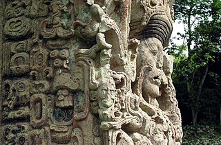
WMaya stelae are monuments that were fashioned by the Maya civilization of ancient Mesoamerica. They consist of tall, sculpted stone shafts and are often associated with low circular stones referred to as altars, although their actual function is uncertain. Many stelae were sculpted in low relief, although plain monuments are found throughout the Maya region. The sculpting of these monuments spread throughout the Maya area during the Classic Period, and these pairings of sculpted stelae and circular altars are considered a hallmark of Classic Maya civilization. The earliest dated stela to have been found in situ in the Maya lowlands was recovered from the great city of Tikal in Guatemala. During the Classic Period almost every Maya kingdom in the southern lowlands raised stelae in its ceremonial centre.
 W
WThe Mesoamerican Long Count calendar is a non-repeating, vigesimal (base 20) and octodecimal (base 18) calendar used by several pre-Columbian Mesoamerican cultures, most notably the Maya. For this reason, it is often known as the Maya Long Count calendar. Using a modified vigesimal tally, the Long Count calendar identifies a day by counting the number of days passed since a mythical creation date that corresponds to August 11, 3114 BCE in the Proleptic Gregorian calendar. The Long Count calendar was widely used on monuments.
 W
WPalenque, also anciently known as Lakamha, was a Maya city state in southern Mexico that flourished in the 7th century. The Palenque ruins date from ca. 226 BC to ca. 799 AD. After its decline, it was overgrown by the jungle of cedar, mahogany, and sapodilla trees, but has since been excavated and restored. It is located near the Usumacinta River in the Mexican state of Chiapas, about 130 km (81 mi) south of Ciudad del Carmen, 150 meters (490 ft) above sea level. It averages a humid 26 °C (79 °F) with roughly 2,160 millimeters (85 in) of rain a year.
 W
WPetexbatún is a small lake formed by a river of the same name, which is a tributary of the La Pasion river. It is near Sayaxché, located in the southern area of the Guatemalan department of Petén.
 W
WPlan de Ayutla is an archaeological site of the pre-Columbian Maya civilization. It is located in the municipality of Ocosingo of the Mexican state of Chiapas. The ruins are notable for having the earliest urban remains in the Upper Usumacinta region, as well as a unique ancient theater for elite use. The ancient identity of the site is subject to debate.
 W
WPuuc is the name of either a region in the Mexican state of Yucatán or a Maya architectural style prevalent in that region. The word puuc is derived from the Maya term for "hill". Since the Yucatán is relatively flat, this term was extended to encompass the large karstic range of hills in the southern portion of the state, hence, the terms Puuc region or Puuc hills. The Puuc hills extend into northern Campeche and western Quintana Roo.
 W
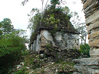
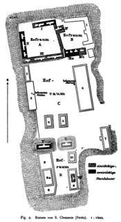
WSan Clemente is a ruin of the ancient Maya civilization in Guatemala. Its main period of occupation dates to the Classic period of Mesoamerican chronology. The ruins were first described in the late 19th century, before being visited by a number of investigators in the early part of the 20th century.
WSanta Elena Poco Uinic is a Classic Maya site in Chiapas, Mexico. It contains Stela 3, that has the date 9.17.19.13.16 5 K'ib' 14 Ch'en and a glyph that indicates an eclipse. An eclipse was recorded as occurring on July 16, 790 CE O.S., so this find has frequently been proposed as a way to establish a correlation between the Maya Calendar and the Julian Calendar.
 W
WTak'alik Ab'aj is a pre-Columbian archaeological site in Guatemala. It was formerly known as Abaj Takalik; its ancient name may have been Kooja. It is one of several Mesoamerican sites with both Olmec and Maya features. The site flourished in the Preclassic and Classic periods, from the 9th century BC through to at least the 10th century AD, and was an important centre of commerce, trading with Kaminaljuyu and Chocolá. Investigations have revealed that it is one of the largest sites with sculptured monuments on the Pacific coastal plain. Olmec-style sculptures include a possible colossal head, petroglyphs and others. The site has one of the greatest concentrations of Olmec-style sculpture outside of the Gulf of Mexico.
 W
WTamarindito is an archaeological site of the Maya civilization located along an escarpment in the Petén department of Guatemala. The city was the capital of the Petexbatún region of the southwestern Petén during the Early Classic period but was displaced by the newly founded conquest state of Dos Pilas. In the 8th century Tamarindito turned on its new overlord and defeated it. After the destruction of the Dos Pilas kingdom the region descended into chaos and suffered rapid population decline. The city was all but abandoned by the 9th century AD.
 W
WTonina is a pre-Columbian archaeological site and ruined city of the Maya civilization located in what is now the Mexican state of Chiapas, some 13 km (8.1 mi) east of the town of Ocosingo.
 W
WUaxactun is an ancient sacred place of the Maya civilization, located in the Petén Basin region of the Maya lowlands, in the present-day department of Petén, Guatemala. The site lies some 12 miles (19 km) north of the major center of Tikal. The name is sometimes spelled as Waxaktun.
 W
WWajxaklajun is a ruin of the ancient Maya civilization situated adjacent to the modern town of San Mateo Ixtatán, in the Huehuetenango Department of Guatemala. Wajxaklajun is considered to be the most important archaeological site in the San Mateo Ixtatán area. The site has been dated to the Classic period. The Chuj Maya consider the city to have been built by their ancestors. The site has similarities with other nearby highland Maya ruins; it is unusual for the presence of a number of stelae, a feature more associated with lowland sites during the Classic period, probably indicating some level of exchange with lowland cities.
 W
WXculoc is a village in Campeche, Mexico. This settlement of Maya people is located 20 kilometres south of Uxmal and the same distance west of Sayil.
 W
WXlapak is a small Maya archaeological site in the Yucatan Peninsula of southeastern Mexico. It is located in the heart of the Puuc region, about 4 kilometres (2.5 mi) from the archaeological site of Labná and a similar distance from Sayil, lying directly between the two sites. It consists of three main groups in a valley of the Puuc Hills in Yucatán State, a region of karst limestone forming the only major topographical feature of the peninsula. The closest town is Oxkutzcab, about 30 kilometres (19 mi) to the northeast.
 W
WYaxchilan is an ancient Maya city located on the bank of the Usumacinta River in the state of Chiapas, Mexico. In the Late Classic Period Yaxchilan was one of the most powerful Maya states along the course of the Usumacinta River, with Piedras Negras as its major rival. Architectural styles in subordinate sites in the Usumacinta region demonstrate clear differences that mark a clear boundary between the two kingdoms.