 W
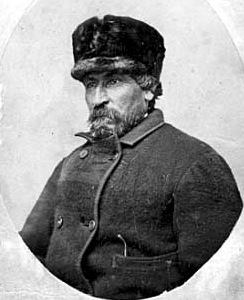
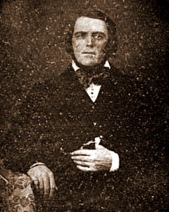
WGiacomo Costantino Beltrami was an Italian jurist, author, and explorer, best known for claiming to have discovered the headwaters of the Mississippi River in 1823 while on a trip through much of the United States. Beltrami County in Minnesota is named for him. He had an extensive network of notable figures for friends and acquaintances, such as members of the powerful Medici family.
 W
WPierre Bottineau was a Minnesota frontiersman.
 W
WJoseph Crétin was the first Roman Catholic Bishop of Saint Paul, Minnesota. Cretin Avenue in St. Paul, Cretin-Derham Hall High School, and Cretin Hall at the University of St. Thomas are named for him.
 W
WThe Treaty of Prairie du Chien may refer to any of several treaties made and signed in Prairie du Chien, Wisconsin between the United States, representatives from the Sioux, Sac and Fox, Menominee, Ioway, Winnebago and the Anishinaabeg Native American peoples.
 W
WFort Duquesne is a historical French former fur trade post. It was built circa 1750 and was first discovered in 1983. The following year, on November 15, 1984, the site was added to the National Register of Historic Places. The site is about two miles north of Little Falls, on the west side of the Mississippi River. Since 2004, the site is part of the Charles A. Lindbergh State Park, as a result of a law passed by the Minnesota Legislature.
 W
WFort Renville was a fur-trading post established by Joseph Renville and built in 1826. There are no visible remains at its site, a half mile from the Lac qui Parle Mission, in Lac qui Parle State Park near Watson, Minnesota, United States. It was a significant post during the fur-trading years, but fell out of use after Renville's death in 1846. The site was excavated in 1940 and is now held in preservation by the Minnesota Historical Society. It is not open to the public.
 W
WFort Ripley was a United States Army outpost on the upper Mississippi River in north-central Minnesota from 1848 to 1877. It was situated near government agencies for the Ho-Chunk and Ojibwe. By its very presence, however, the fort spurred immigration into the area by whites. The post, initially named Fort Marcy, was briefly renamed Fort Gaines and in 1850 was renamed again after Brigadier General Eleazer Wheelock Ripley, a distinguished soldier from the War of 1812. It was the second major military fort established in what would become Minnesota, after Fort Snelling in 1819.
 W
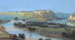
WFort Snelling is a former military fortification and National Historic Landmark in the U.S. state of Minnesota on the bluffs overlooking the confluence of the Minnesota and Mississippi rivers. It is on the Dakota homeland of Bdóte with a history spanning thousands of years. The military site was initially named Fort Saint Anthony, but it was renamed Fort Snelling once its construction was completed in 1825.
 W
WThe glacial history of Minnesota is most defined since the onset of the last glacial period, which ended some 10,000 years ago. Within the last million years, most of the Midwestern United States and much of Canada were covered at one time or another with an ice sheet. This continental glacier had a profound effect on the surface features of the area over which it moved. Vast quantities of rock and soil were scraped from the glacial centers to its margins by slowly moving ice and redeposited as drift or till. Much of this drift was dumped into old preglacial river valleys, while some of it was heaped into belts of hills at the margin of the glacier. The chief result of glaciation has been the modification of the preglacial topography by the deposition of drift over the countryside. However, continental glaciers possess great power of erosion and may actually modify the preglacial land surface by scouring and abrading rather than by the deposition of the drift.
 W
WFather Louis Hennepin, O.F.M. baptized Antoine, was a Belgian Roman Catholic priest and missionary of the Franciscan Recollet order and an explorer of the interior of North America.
 W
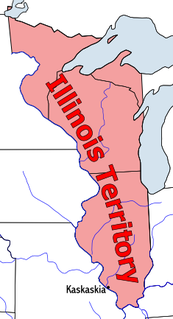
WThe Territory of Illinois was an organized incorporated territory of the United States that existed from March 1, 1809, until December 3, 1818, when the southern portion of the territory was admitted to the Union as the State of Illinois. Its capital was the former French village of Kaskaskia.
 W
W"Indian Reserve" is a historical term for the largely uncolonized area in North America acquired by Great Britain from France through the Treaty of Paris (1763) at the end of the Seven Years' War, and set aside in the Royal Proclamation of 1763 for use by Native Americans, who already inhabited it. The British government had contemplated establishing an Indian barrier state in the portion of the reserve west of the Appalachian Mountains, and bounded by the Ohio and Mississippi rivers and the Great Lakes. British officials aspired to establish such a state even after the region was assigned to the United States in the Treaty of Paris (1783) ending the American Revolutionary War, but abandoned their efforts in 1814 after losing military control of the region during the War of 1812.
 W
WThe Indiana Territory was created by a congressional act that President John Adams signed into law on May 7, 1800, to form an organized incorporated territory of the United States that existed from July 4, 1800, to December 11, 1816, when the remaining southeastern portion of the territory was admitted to the Union as the state of Indiana. The territory originally contained approximately 259,824 square miles (672,940 km2) of land, but its size was decreased when it was subdivided to create the Michigan Territory (1805) and the Illinois Territory (1809). The Indiana Territory was the first new territory created from lands of the Northwest Territory, which had been organized under the terms of the Northwest Ordinance of 1787. The territorial capital was the settlement around the old French fort of Vincennes on the Wabash River, until transferred to Corydon near the Ohio River in 1813.
 W
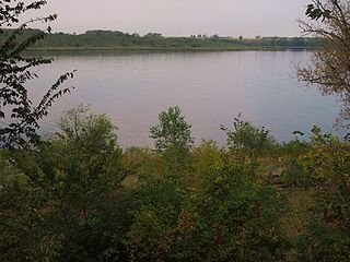
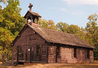
WLac qui Parle Mission is a pre-territorial mission in Chippewa County, Minnesota, United States, which was founded in June 1835 by Dr. Thomas Smith Williamson and Alexander Huggins after fur trader Joseph Renville invited missionaries to the area. Lac qui Parle is a French translation of the native Dakota name, meaning "lake which speaks". In the 19th century, the first dictionary of the Dakota language was written, and part of the Bible was translated into that language for the first time at a mission on the site of the park. It was a site for Christian missionary work to the Sioux for nearly 20 years. Renville was related to and had many friends in the native community, and after his death in 1846, the business was taken over by the "irreligious" Martin McLeod. The Indians became more hostile to the mission, and in 1854 the missionaries abandoned the site and relocated to the Upper Sioux Agency.
 W
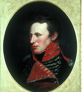
WHenry Leavenworth was an American soldier active in the War of 1812 and early military expeditions against the Plains Indians. He established Fort Leavenworth in Kansas, and named after him is the city of Leavenworth, Kansas, Leavenworth County, Kansas, and the Leavenworth Penitentiary.
 W
WSpanish Louisiana was a governorate and administrative district of the Viceroyalty of New Spain from 1762 to 1801 that consisted of a vast territory in the center of North America encompassing the western basin of the Mississippi River plus New Orleans. The area had originally been claimed and controlled by France, which had named it La Louisiane in honor of King Louis XIV in 1682. Spain secretly acquired the territory from France near the end of the Seven Years' War by the terms of the Treaty of Fontainebleau (1762). The actual transfer of authority was a slow process, and after Spain finally attempted to fully replace French authorities in New Orleans in 1767, French residents staged an uprising which the new Spanish colonial governor did not suppress until 1769. Spain also took possession of the trading post of St. Louis and all of Upper Louisiana in the late 1760s, though there was little Spanish presence in the wide expanses of the "Illinois Country".
 W
WThe Territory of Michigan was an organized incorporated territory of the United States that existed from June 30, 1805, until January 26, 1837, when the final extent of the territory was admitted to the Union as the State of Michigan. Detroit was the territorial capital.
 W
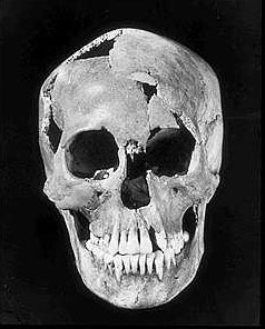
WMinnesota Woman, also known as Pelican Rapids-Minnesota Woman, is the skeletal remains of a woman thought to be 8,000 years old. The bones were found near Pelican Rapids, Minnesota on June 16, 1931, during construction on U.S. Route 59. The bones were brought to Dr. Albert Jenks at the University of Minnesota, who identified them as the bones of a woman who was 15 or 16 years old, but who had never borne children. The woman had two artifacts—a dagger made from an elk's horn and a conch shell pendant. The conch shell came from a snail species known as Busycon perversum, which had previously only been known to exist in Florida.
 W
WJoseph Nicolas Nicollet, also known as Jean-Nicolas Nicollet, was a French geographer, astronomer, and mathematician known for mapping the Upper Mississippi River basin during the 1830s. Nicollet led three expeditions in the region between the Mississippi and Missouri Rivers, primarily in Minnesota, South Dakota, and North Dakota.
 W
WThe Northwest Territory, also known as the Old Northwest and formally known as the Territory Northwest of the River Ohio, was formed in the United States after the American Revolutionary War. Established in 1787 by the Congress of the Confederation through the Northwest Ordinance, it was the nation's first post-colonial organized incorporated territory.
 W
WOld Crow Wing is a ghost town in Fort Ripley Township, Crow Wing County, Minnesota, United States, at the confluence of the Mississippi and Crow Wing rivers. Long occupied by the Ojibwe people, for over a century it was also the northernmost European-American settlement on the Mississippi.
 W
WPierre "Pig's Eye" Parrant, or Pierre Parent, was the first person of European descent to live within the borders of what would eventually become the city of Saint Paul, Minnesota. His exploits propelled him to local fame and infamy, with his name briefly adorning the village that would one day become Minnesota's capital city.
 W
WThe Pembina Region, also referred to as the Pembina District and Pembina Department, is the historic name of an unorganized territory of land that was ceded to the United States. The area included parts of what became North Dakota and a portion of central eastern to northeastern South Dakota. The eastern boundary was the Red River and included the Pembina River area. The region was formerly part of British Rupert's Land and the Red River Colony, that encompassed an area then known as the Assiniboia District, from 1763 to the signing of the Treaty of 1818. The treaty transferred the region that was south of the 49th parallel from the British to the United States.
 W
WZebulon Montgomery Pike was an American brigadier general and explorer for whom Pikes Peak in Colorado was named. As a U.S. Army officer he led two expeditions under authority of President Thomas Jefferson through the new Louisiana Purchase territory, first in 1805–1806 to reconnoiter the upper northern reaches of the Mississippi River, and then in 1806–1807 to explore the Southwest to the fringes of the northern Spanish-colonial settlements of New Mexico and Texas. Pike's expeditions coincided with other Jeffersonian expeditions, including the Lewis and Clark Expedition (1804–1806) and the Thomas Freeman and Peter Custis expedition up the Red River (1806).
 W
WAugustin Ravoux was a French Jesuit priest and missionary who served in the area preceding Roman Catholic Archdiocese of Saint Paul and Minneapolis, in Minnesota.
 W
WJoseph Rolette was a well-known American fur trader and politician during Minnesota's territorial era and the Civil War. His father was Jean Joseph Rolette, often referred to as Joe Rolette the elder, a French-Canadian and a trader himself. Joseph Rolette’s mother was Jane Fisher, who married Joe Rolette, Sr. in 1818 when she was either 13 or 14 years old. Jane's relatives took young Joseph to New York. Joseph's parents never divorced because they were Catholics, but the couple became separated in 1836. As part of the settlement, Joe Senior built what is today known as the Brisbois House for his estranged wife on Water Street, St. Feriole Island, Prairie du Chien, WI.
 W
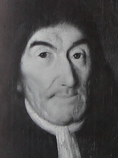
WHenry Rowe Schoolcraft was an American geographer, geologist, and ethnologist, noted for his early studies of Native American cultures, as well as for his 1832 expedition to the source of the Mississippi River. He is also noted for his major six-volume study of Native Americans published in the 1850s.
 W
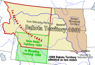
WThe territorial era of Minnesota lasted from the Louisiana Purchase in 1803 to Minnesota's achieving statehood in 1858. The Minnesota Territory itself was formed only in 1849 but the area had a rich history well before this. Though there was a long history of European presence in the area before 19th century, it was during the 19th century that the United States began to establish a firm presence in what would become Minnesota.
 W
WThe Convention respecting fisheries, boundary and the restoration of slaves between the United States and the United Kingdom, also known as the London Convention, Anglo-American Convention of 1818, Convention of 1818, or simply the Treaty of 1818, is an international treaty signed in 1818 between the above parties. This treaty resolved standing boundary issues between the two nations. The treaty allowed for joint occupation and settlement of the Oregon Country, known to the British and in Canadian history as the Columbia District of the Hudson's Bay Company, and including the southern portion of its sister district New Caledonia.
 W
WThe Treaty of La Pointe may refer to either of two treaties made and signed in La Pointe, Wisconsin between the United States and the Ojibwe (Chippewa) Native American peoples. In addition, the Isle Royale Agreement, an adhesion to the first Treaty of La Pointe, was made at La Pointe.
 W
WThe Treaty of Traverse des Sioux was signed on July 23, 1851, at Traverse des Sioux in Minnesota Territory between the United States government and Sioux Indian bands in Minnesota Territory. By this treaty, the Sioux ceded large tracts of territory and agreed to move on to reservations along the Minnesota River in exchange for annuities of cash and goods.
 W
WThe Territory of Wisconsin was an organized incorporated territory of the United States that existed from July 3, 1836, until May 29, 1848, when an eastern portion of the territory was admitted to the Union as the State of Wisconsin. Belmont was initially chosen as the capital of the territory. In 1837, the territorial legislature met in Burlington, just north of the Skunk River on the Mississippi, which became part of the Iowa Territory in 1838. In that year, 1838, the territorial capital of Wisconsin was moved to Madison.