 W
WAchter Kol was the name given to the region around the Newark Bay and Hackensack River in northeastern New Jersey by the first European settlers to it and was part of the 17th century province of New Netherland, originally administered by the Dutch West India Company. At the time of their arrival, the area was inhabited by the Hackensack and Raritan groups of Lenape.
 W
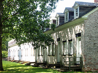
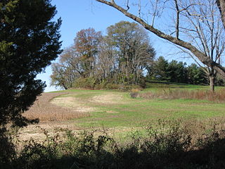
WAllaire Village is a living history museum located within New Jersey's Allaire State Park in Wall Township, Monmouth County, New Jersey. The property was initially an Indian ceremonial ground prior to 1650, by 1750 a sawmill had been established on the property by Issac Palmer. The village was later established as a bog iron furnace originally known as Williamsburg Forge 'Monmouth Furnace' was then renamed the Howell Works by Benjamin B. Howell. In 1822, it was then purchased by philanthropist James P. Allaire, who endeavoured to turn into a self-contained community. The wood burning furnace business collapsed in 1846 and the village closed. During its height, the town supported about 500 people. Following his death, the property passed through a number of family members before being used by the Boy Scouts who started to restore the buildings for use as a summer camp. Losing the lease, the property then passed to the State of New Jersey. Allaire Village and its existing buildings are now operated by a non-profit organization - Allaire Village, Inc. Historic interpreters work using period tools and equipment in the blacksmith, tinsmith, and carpentry shops, while the old bakery sells cookies, and general store serves as a museum store. The church building is frequently used for weddings. The site is also host to community events such as community band concerts, Antique sale, weekly Flea Markets and Square Dance Competitions.
 W
WBatsto Village is a historic unincorporated community located on CR 542 within Washington Township in Burlington County, New Jersey, United States. It is located in Wharton State Forest in the south central Pine Barrens, and a part of the Pinelands National Reserve. It is listed on the New Jersey and National Register of Historic Places, and is administered by the New Jersey Department of Environmental Protection's Division of Parks & Forestry. The name is derived from the Swedish bastu, bathing place ; the first bathers were probably the Lenni Lenape Native Americans.
 W
WBergen Square, at the intersection of Bergen Avenue and Academy Street in Jersey City, is in the southwestern part of the much larger Journal Square district. A commercial residential area, it contains an eclectic array of architectural styles including 19th-century row houses, Art Deco retail and office buildings, and is the site of the longest continually-used school site in the United States. Nearby are the Van Wagenen House and Old Bergen Church, two structures from the colonial period. St. George & St. Shenouda Coptic Orthodox Church founded by early Egyptian immigrants was one of the original Coptic congregations in New Jersey.
WBergen was a part of the 17th century province of New Netherland, in the area in northeastern New Jersey along the Hudson and Hackensack Rivers that would become contemporary Hudson and Bergen Counties. Though it only officially existed as an independent municipality from 1661, with the founding of a village at Bergen Square, Bergen began as a factorij at Communipaw circa 1615 and was first settled in 1630 as Pavonia. These early settlements were along the banks of the North River across from New Amsterdam, under whose jurisdiction they fell.
 W
WThe Boonton Iron Works were founded about 1770 by Samuel Ogden who, with others in his family, purchased a 6-acre (24,000 m2) tract along the Rockaway River, near Boonton, New Jersey, United States. Here rolling and slitting mills were erected that engaged in the manufacture of nail rods and bar iron. With the construction of the Morris Canal in 1830, the New Jersey Iron Company was organized. This company built a new plant costing $283,000 and imported skilled mechanics from England. Under Fuller & Lord (1852–1876) the enterprise tended to become an integrated industry with ore and timber reserves, canal boats, furnaces, mills and auxiliary plants. After 1881, the business slowly declined. The plant closed in 1911.
 W
WThe Charter of Freedoms and Exemptions, sometimes referred to as the Charter of Privileges and Exemptions, is a document written by the Dutch West India Company in an effort to settle its colony of New Netherland in North America through the establishment of feudal patroonships purchased and supplied by members of the West India Company. Its 31 articles establish ground rules and expectations of the patroons and inhabitants of the new colonies. It was ratified by the Dutch States-General on June 7, 1629.
 W
WThe territory which would later become the state of New Jersey was settled by Dutch and Swedish colonists in the early seventeenth century. In 1664, at the onset of the Second Anglo-Dutch War, English forces under Richard Nicolls ousted the Dutch from control of New Netherland, and the territory was divided into several newly defined English colonies. Despite one brief year when the Dutch retook the colony (1673–74), New Jersey would remain an English possession until the American colonies declared independence in 1776.
 W
WJasper Danckaerts was the founder of a colony of Labadists along the Bohemia River in what is now the US state of Maryland. He is known for his journal, kept while traveling through the territory which had previously been part of the New Netherland. Documenting his journey in 1679-1680, it offers a description of the landscape and the lifestyle of inhabitants of the region in the late 17th century.
 W
WThe Dominion of New England in America (1686–89) was an administrative union of English colonies covering New England and the Mid-Atlantic Colonies. Its political structure represented centralized control similar to the model used by the Spanish monarchy through the Viceroyalty of New Spain. The dominion was unacceptable to most colonists because they deeply resented being stripped of their rights and having their colonial charters revoked. Governor Sir Edmund Andros tried to make legal and structural changes, but most of these were undone and the Dominion was overthrown as soon as word was received that King James II had left the throne in England. One notable change was the introduction of the Church of England into Massachusetts, whose Puritan leaders had previously refused to allow it any sort of foothold.
 W
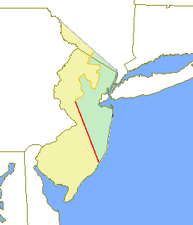
WThe Province of East Jersey, along with the Province of West Jersey, between 1674 and 1702 in accordance with the Quintipartite Deed were two distinct political divisions of the Province of New Jersey, which became the U.S. state of New Jersey. The two provinces were amalgamated in 1702. East Jersey's capital was located at Perth Amboy. Determination of an exact location for a border between West Jersey and East Jersey was often a matter of dispute.
 W
WEast Jersey Old Town Village is an open-air museum located in Johnson Park in Piscataway, New Jersey. The Village is a collection of Raritan Valley area historic buildings and includes original, reconstructed, and replicated 18th and 19th century vernacular architecture typical of farm and merchant communities of Central Jersey. It is home to a permanent exhibition about Raritan Landing, an 18th-century inland port once located just downstream on the river. Since 1989, the Middlesex County Office of Arts and History has had responsibility for the village.
 W
WThe Keith line was a line drawn through the Province of New Jersey, dividing it into the Province of West Jersey and the Province of East Jersey. The line was created by Surveyor-General George Keith in 1686, when he ran the first survey to mark out the border between West Jersey and East Jersey. The Keith line was intended to clarify disputes resulting from the 1676 Quintipartite Deed, which created the two territories.
 W
WMount Pleasant is a historic community located within the southeastern range of Mansfield Township and the northeastern range of Springfield Township, Burlington County, New Jersey. Mount Pleasant encompasses the intersection of Mount Pleasant Road and Gaunt's Bridge Road, 40°3′56″N 74°40′4″W. The intersection is located about three miles (5 km) east of Columbus and one mile (1.7 km) south of Georgetown.
 W
WNew Barbadoes Neck is the name given in the colonial era for the peninsula in northeastern New Jersey, USA between the lower Hackensack and Passaic Rivers, in what is now western Hudson County and southern Bergen County. The neck begins in the south at Kearny Point in the Newark Bay and is characterized by a ridge along the west and part of the New Jersey Meadowlands on the east.
 W
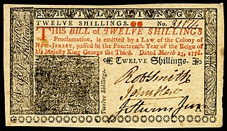
WThe pound was the money of account of New Jersey until 1793. Initially, the British pound and some foreign currencies circulated, supplemented from 1709 by local paper money. However, although the notes were denominated in pounds, shillings and pence, they did not have the same value as the British pound sterling or of other colonial currencies with denominations in pounds. A proclamation of Queen Anne, issued in 1704 and legislated by parliament in 1707, standardized the value of all colonial currencies at 6 colonial schillings to a full weight Spanish Milled Dollar, which was in turn equivalent to 4 shillings 6 pence sterling. This made a colonial schilling equivalent to nine pence sterling and a colonial pound equivalent to 2 troy oz 18 dwt 8 gr of silver. Currency issued at this rate was referred to as “Proclamation Money”.
 W
WThe New York – New Jersey Line War was a series of skirmishes and raids that took place for over half a century between 1701 and 1765 at the disputed border between two American colonies, the Province of New York and the Province of New Jersey.
 W
WNewark Academy is a coeducational private day school located in Livingston, in Essex County, New Jersey, United States, serving students in sixth through twelfth grades. The school has been accredited by the Middle States Association of Colleges and Schools Commission on Elementary and Secondary Schools since 1928.
 W
WOld Upper Springfield Friends Burying Ground is a cemetery located in Springfield Township and Wrightstown, in Burlington County, New Jersey.
 W
WThe Pahaquarry Copper Mine is an abandoned copper mine located on the west side of Kittatinny Mountain presently in Hardwick Township in Warren County, New Jersey in the United States. Active mining was attempted for brief periods during the mid-eighteenth, mid-nineteenth, and early twentieth centuries but was never successful despite developments in mining technology and improving mineral extraction methods. Such ventures were not profitable as the ore extracted proved to be of too low a concentration of copper. This site incorporates the mining ruins, hiking trails, and nearby waterfalls, and is located within the Delaware Water Gap National Recreation Area and administered by the National Park Service.
 W
WPavonia was the first European settlement on the west bank of the North River that was part of the seventeenth-century province of New Netherland in what would become the present Hudson County, New Jersey.
 W
WThe Peach Tree War, also known as the Peach War, was a large-scale attack on September 15, 1655 by the Susquehannock Indians and allied tribes on several New Netherland settlements along the North River.
 W
WCity Hall in Perth Amboy, Middlesex County, New Jersey, United States, is a historic building built in the early 18th century, listed on New Jersey Register of Historic Places and the National Register of Historic Places. It is now the oldest City Hall still in use in the United States.
 W
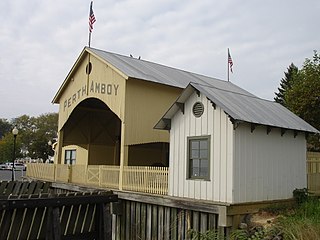
WThe Perth Amboy Ferry Slip, located on Arthur Kill in Perth Amboy, Middlesex County, New Jersey, United States, was once a vital ferry slip for boats in New York Harbor. It was added to the New Jersey Register of Historic Places and National Register of Historic Places in 1978. The ferry slip was restored in 1998 to its 1904 appearance. A replica of the ticket office has been constructed and is used as a small museum.
 W
WThe Province of New Jersey was one of the Middle Colonies of Colonial America and became New Jersey, a state of the United States in 1783. The province had originally been settled by Europeans as part of New Netherland, but came under English rule after the surrender of Fort Amsterdam in 1664, becoming a proprietary colony. The English then renamed the province after the Isle of Jersey in the English Channel. The Dutch Republic reasserted control for a brief period in 1673–1674. After that it consisted of two political divisions, East Jersey and West Jersey, until they were united as a royal colony in 1702. The original boundaries of the province were slightly larger than the current state, extending into a part of the present state of New York, until the border was finalized in 1773.
WThe Quintipartite Deed was a legal document that split the Province of New Jersey, dividing it into the Province of West Jersey and the Province of East Jersey from 1674 until 1702.
 W
WRaritan Landing is a historical unincorporated community located within Piscataway Township in Middlesex County, New Jersey, United States, which was once an inland port, the farthest upstream point ocean-going ships could reach along the Raritan River, across from New Brunswick. Begun in the early 18th century it remained vital until the mid 19th century, when most of the port was abandoned.
 W
WThe Road Up Raritan Historic District is located along River Road in Piscataway, Middlesex County, New Jersey. It is north of Raritan Landing, once an important inland port on the Raritan River during the 18th and 19th centuries. The name is taken from an earlier colonial era name for what was once a Lenape path, Assunpink Trail that became a main road parallel to the river. Piscataway Township itself was formed on December 18, 1666 as one of the first seven townships in East Jersey, and is one of the oldest municipalities in the state. The district includes nine of fourteen historic homes along an approximately 1.2 miles stretch of River Road. The Metlar-Bodine House and the Cornelius Low House are also in the immediate vicinity.
 W
WThe Schuyler Copper Mine is an abandoned, historic copper mine located in what is now North Arlington in Bergen County, New Jersey, United States. Operations began in 1715, making it the earliest copper mine in New Jersey and one of the oldest in the United States. In 1755, it was the site of the first use of a steam engine assembled in America. Later, starting in 1794, the first steam engine was manufactured in the United States near here. Shortly before and after, but not during, the revolutionary war, the mine was a major copper producer. Even though nothing remains of the mining operations above ground, the collapse of the underground shafts and tunnels caused damage as recently as 1989.
 W
WCasper Shafer was among the first settlers of the village of Stillwater along the Paulins Kill in Sussex County, New Jersey in the United States. A successful miller and early tavern owner, Shafer later served in the first sessions of the New Jersey Legislature during the American Revolution. During these sessions, New Jersey had become a newly independent state, established the first state constitution, ordered the state's last Royal Governor deposed and arrested, and actively supported and financed the Continental Army.
 W
WVriessendael was a patroonship on the west bank of the Hudson River in New Netherland, the seventeenth century North American colonial province of the Dutch Empire. The homestead or plantation was located on a tract of about 500 acres (2.0 km2) about an hour's walk north of Communipaw at today's Edgewater. It has also been known as Tappan, which referred to the wider region of the New Jersey Palisades, rising above the river on both sides of the New York/New Jersey state line, and to the indigenous people who lived there and were part of wider group known as Lenape. It was established in 1640 by David Pietersen de Vries, a Dutch sea captain, explorer, and trader who had also established settlements at the Zwaanendael Colony and on Staten Island. The name can roughly be translated as De Vries' Valley. De Vries also owned flatlands along the Hackensack River, in the area named by the Dutch settlers Achter Col. Parts of Vriessendael were destroyed in 1643 in reprisal for the slaughter of Tappan and Wecquaesgeek Native Americans who had taken refuge at Pavonia and Corlears Hook. The patroon's relatively good relations with the Lenape prevented the murder of the plantation's residents, who were able to seek sanctuary in the main house, and later flee to New Amsterdam. The incident was one of the first of many to take place during Kieft's War, a series of often bloody conflicts with bands of Lenape, who had united in face of attacks ordered by the Director of New Netherland.
WWest Jersey and East Jersey were two distinct parts of the Province of New Jersey. The political division existed for 28 years, between 1674 and 1702. Determination of an exact location for a border between West Jersey and East Jersey was often a matter of dispute.
 W
W