 W
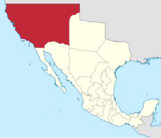
WThe Californias, occasionally known as the Three Californias or Two Californias, are a region of North America spanning the United States and Mexico, consisting of the U.S. state of California and the Mexican states of Baja California and Baja California Sur. Historically, the term Californias was used to define the vast northwestern region of Spanish America, as the Province of the Californias, and later as a collective term for Alta California and the Baja California Peninsula.
 W
WThe Viceroyalty of New Spain was an integral territorial entity of the Spanish Empire, established by Habsburg Spain during the Spanish colonization of the Americas. It covered a huge area that included much of North America, northern parts of South America and several Pacific Ocean archipelagos, namely Philippines and Guam. It originated in 1521 after the fall of Tenochtitlan, the main event of the Spanish conquest, and officially created on 18 August 1521 as a kingdom, the first of four viceroyalties Spain created in the Americas. Its first viceroy was Antonio de Mendoza y Pacheco, and the capital of the kingdom was Mexico City, established on the ancient Tenochtitlan.
WThe Provincias Internas, also known as the Comandancia y Capitanía General de las Provincias Internas, was an administrative district of the Spanish Empire created in 1776 to provide more autonomy for the frontier provinces of the Viceroyalty of New Spain, present-day northern Mexico and the Southwestern United States. The goal of its creation was to establish a unified government in political, military and fiscal affairs. Nevertheless, the Commandancy General experienced significant changes in its administration because of experimentation to find the best government for the frontier region as well as bureaucratic in-fighting. Its creation was part of the Bourbon Reforms and was part of an effort to invigorate economic and population growth in the region to stave off encroachment on the region by foreign powers. During its existence, the Commandancy General encompassed the Provinces of Sonora y Sinaloa, Nueva Vizcaya, Las Californias, Nuevo México, Nuevo Santander, Nuevo Reyno de León, Coahuila and Texas.
WThe Viceroyalty of New Spain was an integral territorial entity of the Spanish Empire, established by Habsburg Spain during the Spanish colonization of the Americas. It covered a huge area that included much of North America, northern parts of South America and several Pacific Ocean archipelagos, namely Philippines and Guam. It originated in 1521 after the fall of Tenochtitlan, the main event of the Spanish conquest, and officially created on 18 August 1521 as a kingdom, the first of four viceroyalties Spain created in the Americas. Its first viceroy was Antonio de Mendoza y Pacheco, and the capital of the kingdom was Mexico City, established on the ancient Tenochtitlan.
 W
WAlta California, also known as Nueva California, among other names, was a province of New Spain, formally established in 1804. Along with the Baja California peninsula, it had previously comprised the province of Las Californias, but was split off into a separate province in 1804. Following the Mexican War of Independence, it became a territory of Mexico in April 1822 and was renamed Alta California in 1824. The claimed territory included all of the modern US states of California, Nevada and Utah, and parts of Arizona, Wyoming, Colorado and New Mexico. In the 1836 Siete Leyes government reorganization, the two Californias were once again combined. That change was undone in 1846, but rendered moot by the U.S. military occupation of California in the Mexican-American War.
 W
WJuan Bautista de Anza was born in the Spanish province of New Navarre in Viceroyalty of New Spain. Of Basque descent, he served as an expeditionary leader, military officer, and politician primarily in California and New Mexico under the Spanish Empire. He is credited as one of the founding fathers of Spanish California and served as an official within New Spain as Governor of the Province of New Mexico.
 W
WBaja California Territory was a Mexican territory from 1824 to 1931, that encompassed the Baja California Peninsula of present-day northwestern Mexico. It replaced the Baja California Province (1773–1824) of the Spanish colonial Viceroyalty of New Spain, after Mexican independence. Along with Alta California, the two territories were split from the Spanish The Californias region.
 W
WBranciforte, originally named Villa de Branciforte, was the last of only three secular pueblos founded by the Spanish colonial government of Alta California. The pueblo was established in 1797 on the eastern bluff of the San Lorenzo River, facing Mission Santa Cruz on the west side of the river. The pueblo never prospered, and the area was annexed into the city of Santa Cruz, California in 1905.
 W
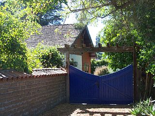
WThe Branciforte Adobe, also known as the Craig-Lorenzana Adobe, is the only remaining dwelling from the Villa de Branciforte, the settlement that was established in 1797 at the time of the Mission Santa Cruz.
 W
WCabrillo National Monument is at the southern tip of the Point Loma Peninsula in San Diego, California, United States. It commemorates the landing of Juan Rodríguez Cabrillo at San Diego Bay on September 28, 1542. This event marked the first time a European expedition had set foot on what later became the West Coast of the United States. The site was designated as California Historical Landmark #56 in 1932. As with all historical units of the National Park Service, Cabrillo was listed on the National Register of Historic Places on October 15, 1966.
 W
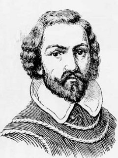
WJuan Rodríguez Cabrillo was an Iberian maritime explorer best known for investigations of the West Coast of North America, undertaken on behalf of the Spanish Empire. He was the first European to explore present-day California, navigating along the coast of California in 1542–1543.
 W
WThe California Genocide consisted of actions from the 18th to late 19th century by the Spanish, Mexican and especially United States federal, state, and local governments that resulted in the dramatic decrease of the indigenous population of California. Between 1849 and 1870—following the U.S. occupation of California in 1846—it is conservatively estimated that American colonists murdered some 9,500 California Natives, and acts of enslavement, kidnapping, rape, child separation and displacement were widespread, encouraged, carried out by and tolerated by state authorities and militias.
 W
WCalifornios are Hispanic people native to the U.S. state of California. California's Spanish-speaking community has resided there since 1683 and is made up of varying Criollo Spaniard, Mestizo, and Indigenous Californian origins. Alongside the Tejanos of Texas and Neomexicanos of New Mexico and Colorado, Californios are part of the larger Chicano/Mexican-American/Hispano community of the United States, which has inhabited the American Southwest and the West Coast since the 16th century.
 W
WThe Capture of Monterey by the United States Navy and Marine Corps occurred in 1842. After hearing false news that war had broken out between the United States and Mexico, the commander of the Pacific Squadron Thomas ap Catesby Jones sailed from Lima, Peru with three warships to Monterey, California. The Americans' objective was to take control of the capital city before a suspected British cession could be achieved.
 W
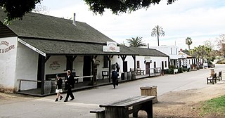
WThe Cosmopolitan Hotel and Restaurant in the Old Town San Diego State Historic Park is a registered national historic landmark, built in the early 19th century by Juan Bandini and later purchased by Albert Seeley to serve as a stagecoach hotel. In 2010, restorations and added fine dining restaurant revived the hotel to its 1870s charm, making it again a focal point of the original downtown area.
 W
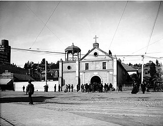
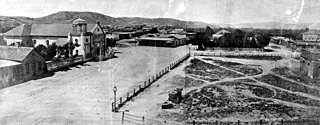
WThe El Pueblo de Los Ángeles Historical Monument, also known as Los Angeles Plaza Historic District and formerly known as El Pueblo de Los Ángeles State Historic Park, is a historic district taking in the oldest section of Los Angeles, known for many years as El Pueblo de Nuestra Señora la Reina de los Ángeles del Río de Porciúncula. The district, centered on the old plaza, was the city's center under Spanish (1781–1821), Mexican (1821–1847), and United States rule through most of the 19th century. The 44-acre park area was designated a state historic monument in 1953 and listed on the National Register of Historic Places in 1972.
 W
WFort Guijarros was a Spanish fort in what is now San Diego, California, USA. The name means "Fort Cobblestones" in English. It was built in 1797 on Ballast Point as the first defensive fortifications for San Diego Bay. It was involved in the Battle of San Diego, a naval battle between the fort and an American trading vessel. The site is registered as California Historical Landmark #69.
 W
WLa Iglesia de Nuestra Señora la Reina de los Ángeles,, is a historic Roman Catholic church in El Pueblo de los Ángeles Historical Monument in northern downtown Los Angeles, California, United States. The church was founded by the Spanish in the early 19th century when modern-day California was under Spanish rule and known as Alta California in the Viceroyalty of New Spain.
 W
WEl Pueblo de Nuestra Señora la Reina de los Ángeles, shortened to Pueblo de los Ángeles, was the Spanish civilian pueblo settled in 1781, which by the 20th century became the American metropolis of Los Angeles. The pueblo was built using labor from the adjacent village of Yaanga and was totally dependent on local Indigenous labor for its survival.
 W
WThe Mohave Trail was a Native American trade route between Mohave Indian villages on the Colorado River and settlements in coastal Southern California.
 W
WOld Town San Diego State Historic Park, located in the Old Town neighborhood of San Diego, California, is a state protected historical park in San Diego. It commemorates the early days of the City of San Diego and includes many historic buildings from the period 1820 to 1870. The park was established in 1968. In 2005 and 2006, California State Parks listed Old Town San Diego as the most visited state park in California.
 W
WThe Pious Fund of the Californias is a fund, originating in 1697, to sponsor the Roman Catholic Jesuit Spanish missions in Baja California, and Franciscan Spanish missions in Alta California in the Viceroyalty of New Spain from 1769 to 1823, and originally administered by the Jesuits. It became the object of litigation between the US and Mexican governments in the 19th century, with the resolution making legal history in The Hague in 1902.
 W
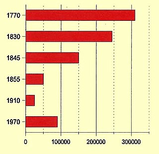
WThe Population of Native California refers to the population of Indigenous peoples of California. Estimates prior to and after European contact have varied substantially. Pre-contact estimates range from 133,000 to 705,000 with some recent scholars concluding that these estimates are low.
 W
WThe Portolá expedition was a Spanish voyage of exploration in 1769–1770 that was the first recorded European land entry and exploration of the interior of the present-day U.S. state of California. It was led by Gaspar de Portolá, governor of Las Californias, the Spanish colonial province that included California, Baja California, and other parts of present-day Mexico and the United States. The expedition led to the founding of Alta California and contributed to the solidification of Spanish territorial claims in the disputed and unexplored regions along the Pacific coast of North America.
 W
WThis timeline of the Portolá expedition tracks the progress during 1769 and 1770 of the first European exploration-by-land of north-western coastal areas in what became Las Californias, a province of Spanish colonial New Spain. Later, the region was administratively-split into Baja and Alta. The first section of the march was on the Baja California peninsula, and the northern section of the expedition's trail was in today's U.S.A. state of California.
 W
WThe Portolá Trail Campsite 2 or Portolá Trail Campsite No. 2 is the spot of the first Europeans to travel and camp overnight in what is now Beverly Hills, California. The Portolá expedition camped at the site on August 3, 1769. The Portolá Trail Campsite No. 2 was designated a California Historic Landmark (No.665) on Nov. 5, 1958. The Portolá Trail Campsite is located in what is now 325 South La Cienega Boulevard between Olympic Boulevard and Gregory, in Beverly Hills. in Los Angeles County. Military officer Gaspar de Portolá was the commander of the expedition for the Spanish Empire with the goal of the Spanish colonization of the Americas. The expedition led to the founding of the first mission in the Los Angeles Basin, the Mission Vieja, on September 8, 1771 and of Alta California. The expedition arrived at Portolá Trail Campsite No. 2 from the Portolá Trail Campsite No. 1 in what is now Elysian Park. They came to camp site 1 from the San Gabriel Valley, were the Mission San Gabriel would be built later in 1776. As they depart Portolá Trail Campsite No. 2 they traveled west towards Santa Monica Bay. At San Monica Bay the expedition turned and traveled north to were the future Mission San Fernando would be built in 1797. Form San Fernando the expedition turned west to Ventura, the site of the future Mission San Buenaventura built in 1782.Listed on the state historic mark #665 at the site:Don Gaspar de Portolá (1723–1786) – Expedition Leader would become the first Governor of the Californias. Captain Don Fernando Rivera y Moncada (1725–1781) – soldier and became the third Governor of The Californias. Lieutenant Don Pedro Fages (1734–1794) – soldier, became Lieutenant Governor under Gaspar de Portolá. Sgt. José Francisco Ortega (1734–1798) – soldier and early settler of Alta California. Future leader of the Presidio of San Diego. Father Juan Crespí (1721–1782) – recorded the complete expedition. Founder of first mission in area. Father Francisco Gómez – served as chaplain for the expedition, a Father from Mission San Diego, later moved to Mission Carmel.
 W
WThe Portolá Trail Campsite or Portolá Trail Campsite No. 1 is the spot of the first Europeans to travel and camp overnight in what is now Central Los Angeles, California. The Portolá expedition camped at the site on August 2, 1769. The Portolá Trail Campsite No. 1 was designated a California Historic Landmark (No.655) on Sept. 26, 1958. The Portolá Trail Campsite is located in what is now the Elysian Park entrance, at the NW corner of North Broadway and Elysian Park Drive in the City of Los Angeles in Los Angeles County. The campsite is near the Los Angeles River, which they used as their water supply for the camp. Military officer Gaspar de Portolá was the commander of the expedition for the Spanish Empire with the goal of the Spanish colonization of the Americas. The expedition led to the founding of the first mission in the Los Angeles Basin, the Mission Vieja, on September 8, 1771 and of Alta California. The expedition arrived at Portolá Trail Campsite No. 1 from the San Gabriel Valley, were the Mission San Gabriel would be built later in 1776. As they depart Portolá Trail Campsite No. 1 they traveled west towards Santa Monica Bay, stopping at Portolá Trail Campsite 2, which is in present day Beverly Hills. Portolá Trail Campsite 2 is also a California Historic Landmark (No.665). At San Monica Bay the expedition turned and traveled north to were the future Mission San Fernando would be built in 1797. Form San Fernando the expedition turned west to Ventura, the site of the future Mission San Buenaventura built in 1782.Listed on the State Marker 655:Don Gaspar de Portolá (1723–1786) – Expedition Leader would become the first Governor of the Californias. Captain Don Fernando Rivera y Moncada (1725–1781) – soldier and became the third Governor of The Californias. Lieutenant Don Pedro Fages (1734–1794) – soldier, became Lieutenant Governor under Gaspar de Portolá. Sgt. José Francisco Ortega (1734–1798) – soldier and early settler of Alta California. Leader of the Presidio of San Diego. Father Juan Crespí (1721–1782) – recorded the complete expedition. Founder of first mission in area. Father Francisco Gómez – served as chaplain for the expedition, a Father from Mission San Diego, later move to Mission Carmel.
 W
WThis article describes the present Diocese of Monterey in California. The entity previously known as the Diocese of Monterey from 1849 until 1859, and subsequently known as the Diocese of Monterey-Los Angeles from 1859 until 1922, is the present Archdiocese of Los Angeles. The entity known as the Diocese of Monterey-Fresno from 1922 until 1967 was canonically suppressed with the simultaneous erection of the present Diocese of Monterey in California and the present Diocese of Fresno.
 W
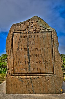
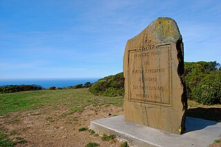
WThe San Francisco Bay Discovery Site is a marker commemorating the first recorded European sighting of San Francisco Bay. In 1769, the Portola expedition traveled north by land from San Diego, seeking to establish a base at the Port of Monterey described by Sebastian Vizcaino in 1602. When they reached Monterey, however, they were not sure it was the right place and decided to continue north. The party reached San Pedro Creek on October 31 and camped there for four nights, while scouts led by José Francisco Ortega climbed Sweeney Ridge, where they could see over the ridge toward the east, and so became the first Europeans to see San Francisco Bay on November 1.
 W
WSan Juan Bautista State Historic Park is a California state park encompassing the historic center of San Juan Bautista, California, United States. It preserves a significant concentration of buildings dating to California's period of Spanish and Mexican control. It includes the Mission San Juan Bautista, the Jose Castro House, and several other buildings facing the historic plaza. It became a state park in 1933 and was declared a National Historic Landmark in 1970. It is also a site on the Juan Bautista de Anza National Historic Trail.
 W
WSpanish claims to the West Coast of North America date to the papal bull of 1493, and the Treaty of Tordesillas. In 1513, this claim was reinforced by Spanish explorer Vasco Núñez de Balboa, the first European to sight the Pacific Ocean, when he claimed all lands adjoining this ocean for the Spanish Crown. Spain only started to colonize the claimed territory north of present-day Mexico in the 18th century, when it settled the northern coast of Las Californias (California).
 W
WThe Spanish missions in California comprise a series of 21 religious outposts or missions established between 1769 and 1833 in what is now the U.S. state of California. Founded by Catholic priests of the Franciscan order to evangelize the Native Americans, the missions led to the creation of the New Spain province of Alta California and were part of the expansion of the Spanish Empire into the most northern and western parts of Spanish North America.
 W
WYerba Buena was the original name of the settlement that later became San Francisco, California. Located near the northeastern end of the San Francisco Peninsula, between the Presidio of San Francisco and the Mission San Francisco de Asís, it was originally intended as a trading post for ships visiting San Francisco Bay. The settlement was arranged in the Spanish style around a plaza that remains as the present day Portsmouth Square.