 W
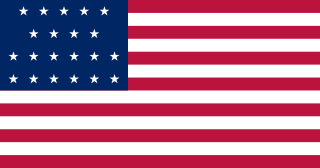
WThe Territory of Alabama was an organized incorporated territory of the United States. The Alabama Territory was carved from the Mississippi Territory on August 15, 1817 and lasted until December 14, 1819, when it was admitted to the Union as the twenty-second state.
 W
WThe Battle of Mobile was a British attempt to recapture the town of Mobile, in the British province of West Florida, from the Spanish during the Anglo-Spanish War. The Spanish had previously captured Mobile in March 1780. On January 7, 1781, a British attack against a Spanish outpost on the east side of Mobile Bay was repulsed, and the German leader of the expedition was killed.
 W
WThe Battle of Talladega was fought between the Tennessee Militia and the Red Stick Creek Indians during the Creek War, in the vicinity of the present-day county and city of Talladega, Alabama, in the United States.
 W
WWest Florida was a colony of the Kingdom of Great Britain from 1763 until 1783 when it was ceded to Spain as part of the Peace of Paris.
 W
WA casquette girl but also known historically as a casket girl or a Pelican girl, was a woman brought from France to the French colonies of Louisiana to marry. The name derives from the small chests, known as casquettes, in which they carried their clothes.
 W
WCherokee history is the written and oral lore, traditions, and historical record maintained by the living Cherokee people and their ancestors. In the 21st century, leaders of the Cherokee people define themselves as those persons enrolled in one of the three federally recognized Cherokee tribes: The Eastern Band of Cherokee Indians, The Cherokee Nation, and The United Keetoowah Band of Cherokee Indians. The first live predominantly in North Carolina; the latter two tribes are based in Oklahoma. The Cherokee people have extensive written records, including detailed genealogical records, preserved in the Cherokee language, the Cherokee syllabary, and in the English language.
 W
WThe Cherokee Nation was a legal, autonomous, tribal government in North America recognized from 1794 to 1907. It was often referred to simply as "The Nation" by its inhabitants. The government was disbanded in 1907, after its land rights had been extinguished, prior to the admission of Oklahoma as a state. During the late 20th century, the Cherokee people reorganized, instituting a government with sovereign jurisdiction known as the Cherokee Nation.
 W
WThe Choctaw Corner is a former Native American boundary location near the modern border between Clarke and Marengo counties in Alabama, United States. It was established as the northernmost terminus for a mutually agreed upon boundary line between the Choctaw and Creek peoples during the Mississippi Territory period. This boundary line, now known as the “Old Indian Treaty Boundary,” starts at the Alabama River cut-off in southernmost Clarke County and follows a northward path through the county along the drainage divide between the Tombigbee and Alabama rivers to the Choctaw Corner, then turns ninety degrees to the west and follows the modern county-line between Clarke and Marengo to the Tombigbee River.
 W
WThe Creek War (1813–1814), also known as the Red Stick War and the Creek Civil War, was a regional war between opposing Creek factions, European empires and the United States, taking place largely in today's Alabama and along the Gulf Coast. The major conflicts of the war took place between state militia units and the "Red Stick" Creeks.
 W
WAndrew Dexter Jr., was an American lawyer, financier, and speculator. He is known for committing one of the first major financial frauds in the United States, and for being the founder of Montgomery, Alabama.
 W
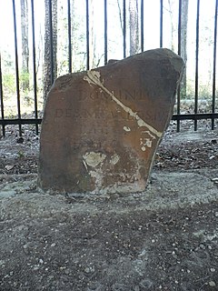
WEllicott's Stone, also known as the Ellicott Stone, is a boundary marker in northern Mobile County, Alabama. It was placed on April 10, 1799 by a joint U.S.-Spanish survey party headed by Andrew Ellicott. It was added to the National Register of Historic Places on April 11, 1973.
WFort Armstrong was a stockade fort built in present-day Cherokee County, Alabama during the Creek War.
WFort Bainbridge was an earthen fort located along the Federal Road on what is today the county line between Macon and Russell counties in Alabama.
WFort Bibb was a stockade fort built in present-day Butler County, Alabama during the First Seminole War.
WFort Bowyer was a short-lived earthen and stockade fortification that the United States Army erected in 1813 on Mobile Point, near the mouth of Mobile Bay in what is now Baldwin County, Alabama, but then was part of the Mississippi Territory. The British twice attacked the fort during the War of 1812.
WFort Crawford was a fort that once provided defense for settlers in what is today East Brewton, Alabama.
WFort Decatur was an earthen fort established in March 1814 on the banks of the Tallapoosa River. The fort was located on the east bank of the Tallapoosa River, near the modern community of Milstead. Fort Decatur was also located near the Creek town of Tukabatchee. It was most likely named for Stephen Decatur.
 W
WFort Mitchell Historic Site is a park and an archaeological site in Fort Mitchell, Alabama, that was declared a National Historic Landmark in 1990. The park features a reconstruction of the 1813 stockade fort that was an important United States military post in the Creek War, a museum with exhibits about the fort's history, and a collection of historic carriages, a restored 19th-century log home, and a visitor center.
 W
WFort Sinquefield is the historic site of a wooden stockade fortification in Clarke County, Alabama, near the modern town of Grove Hill. It was built by early Clarke County pioneers as protection during the Creek War and was attacked in 1813 by Creek warriors.
WFort Stoddert, also known as Fort Stoddard, was a stockade fort in the Mississippi Territory, in what is today Alabama. It was located on a bluff of the Mobile River, near modern Mount Vernon, close to the confluence of the Tombigbee and Alabama Rivers. It served as the western terminus of the Federal Road which ran through Creek lands to Fort Wilkinson in Georgia. The fort, built in 1799, was named for Benjamin Stoddert, the secretary to the Continental Board of War during the American Revolution and Secretary of the Navy during the Quasi War. Fort Stoddert was built by the United States to keep the peace by preventing its own settlers in the Tombigbee District from attacking the Spanish in the Mobile District. While under the command of Captain Edmund P. Gaines, Aaron Burr was held as a prisoner at the fort after his arrest at McIntosh in 1807 for treason against the United States. In July 1813, General Ferdinand Claiborne brought the Mississippi Militia to Fort Stoddert as part of the Creek War. The site declined rapidly in importance after the capture of Mobile by the United States in 1813 and the establishment of the Mount Vernon Arsenal in 1828.
WFort Strother was a stockade fort at Ten Islands in the Mississippi Territory, in what is today St. Clair County, Alabama. It was located on a bluff of the Coosa River, near the modern Neely Henry Dam in Ragland, Alabama. The fort was built by General Andrew Jackson and several thousand militiamen in November 1813, during the Creek War and was named for Captain John Strother, Jackson's chief cartographer. The fort was rectangular in shape and had blockhouses at each corner. It also included a supply building, eight hospital huts, and twenty-five tents.
WFort Williams was a supply depot built in early 1814 in preparation for the Battle of Horseshoe Bend. It was located in Alabama on the southeast shore where Cedar Creek met the Coosa River, near Talladega Springs.
 W
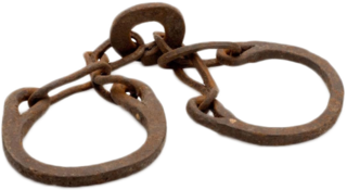
WNative Americans living in the American Southeast were enslaved through warfare and purchased by European colonists throughout the 17th, 18th, and 19th centuries, as well as held in captivity through Spanish-organized forced labor systems in Florida. Emerging colonies in Virginia, Carolina, and Georgia imported Native Americans and incorporated them into chattel slavery systems, where they intermixed with slaves of African descent, who would come to outnumber them. Their demand for slaves affected communities as far west as present-day Illinois and the Mississippi River and as far south as the Gulf Coast. The trade in enslaved Native Americans sent tens of thousands of them outside the region to New England and the Caribbean as a profitable export.
 W
WFort Toulouse and Fort Jackson are two forts that shared the same site at the fork of the Coosa River and the Tallapoosa River, near Wetumpka, Alabama.
 W
WThe Territory of Mississippi was an organized incorporated territory of the United States that existed from April 7, 1798, until December 10, 1817, when the western half of the territory was admitted to the Union as the State of Mississippi. The eastern half was redesignated as the Alabama Territory until it was admitted to the Union as the State of Alabama on December 14, 1819.
 W
WNeamathla was a leader of the Red Stick Creek (1750s–1841). His name, in the Hitchiti (Mikasuki) language, means "fat next to warrior", "fat" being a reference to great courage. The Hitchiti language had no written form, but modern scholars agree that Eneah Emathla is the "proper" spelling of his name in English; however, there were two other men also named Eneah Emathla, so the modern convention is to use the spelling Neamathla for the leader.
 W
WThe Province of North Carolina was a British colony that existed in North America from 1712 to 1776, created as a proprietary colony. The power of the British government was vested in a governor of North Carolina, but the colony declared independence from Great Britain in 1776. The Province of North Carolina had four capitals: Bath (1712–1722), Edenton (1722–1743), Brunswick (1743–1770), and New Bern. The colony later became the states of North Carolina and Tennessee, and parts of the colony combined with other territory to form the states of Georgia, Alabama, and Mississippi.
 W
WThe Old Mobile Site was the location of the French settlement La Mobile and the associated Fort Louis de La Louisiane, in the French colony of New France in North America, from 1702 until 1712. The site is located in Le Moyne, Alabama, on the Mobile River in the Mobile-Tensaw River Delta. The settlement served as the capital of French Louisiana from 1702 until 1711, when the capital was relocated to the site of present-day Mobile, Alabama. The settlement was founded and originally governed by Pierre Le Moyne d'Iberville. Upon the death of d'Iberville, the settlement was governed by his younger brother, Jean-Baptiste Le Moyne de Bienville. The site can be considered a French colonial counterpart to the English settlement at Jamestown, Virginia. The settlement site and fort were listed on the National Register of Historic Places on May 6, 1976. The Old Mobile Site was determined eligible for designation as a National Historic Landmark on January 3, 2001.
 W
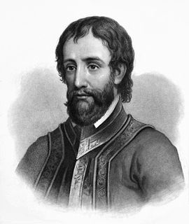
WHernando de Soto was a Spanish explorer and conquistador who was involved in expeditions in Nicaragua and the Yucatan Peninsula, and played an important role in Pizarro's conquest of the Inca Empire in Peru, but is best known for leading the first European expedition deep into the territory of the modern-day United States. He is the first European documented as having crossed the Mississippi River.
 W
WSpanish Florida was the first major European land claim and attempted settlement in North America during the European Age of Discovery. La Florida formed part of the Captaincy General of Cuba, the Viceroyalty of New Spain, and the Spanish Empire during Spanish colonization of the Americas. While its boundaries were never clearly or formally defined, the territory was initially much larger than the present-day state of Florida, extending over much of what is now the southeastern United States, including all of present-day Florida plus portions of Georgia, Alabama, Mississippi, North Carolina, South Carolina, and Louisiana. Spain's claim to this vast area was based on several wide-ranging expeditions mounted during the 16th century. A number of missions, settlements, and small forts existed in the 16th and to a lesser extent in the 17th century; eventually they were abandoned due to pressure from the expanding English and French colonial projects, the collapse of the native populations, and the general difficulty in becoming agriculturally or economically self-sufficient. By the 18th century, Spain's control over La Florida did not extend much beyond a handful of forts near St. Augustine, St. Marks, and Pensacola, all within the boundaries of present-day Florida.
WThe Tombigbee District, also known as the Tombigbee, was one of two areas, the other being the Natchez District, that were the first in what was West Florida to be colonized by British subjects from the Thirteen Colonies and elsewhere. This later became the Mississippi Territory as part of the United States. The district was also the first area to be opened to white settlement in what would become the state of Alabama, outside of the French colonial outpost of Mobile on the Gulf Coast. The Tombigbee and Natchez districts were the only areas populated by whites in the Mississippi Territory when it was formed by the United States in 1798.
 W
WThe Treaty of Fort Jackson was signed on August 9, 1814 at Fort Jackson near Wetumpka, Alabama following the defeat of the Red Stick resistance by United States allied forces at the Battle of Horseshoe Bend. It occurred on the banks of the Tallapoosa River near the present city of Alexander City, Alabama. The U.S. force, led by General Andrew Jackson, consisted mainly of the West Tennessee Militia and 39th United States Infantry, allied with several groups of Cherokee and Lower Creek friendly to the American side. The Upper Creek were led by Chief Menawa, who fled with hundreds of survivors into Florida, where they allied with the Seminole. The surrender ended the Creek War, which the United States was fighting simultaneously with the War of 1812.
 W
WWest Florida was a region on the northern coast of the Gulf of Mexico that underwent several boundary and sovereignty changes during its history. As its name suggests, it was formed out of the western part of former Spanish Florida, along with lands taken from French Louisiana; Pensacola became West Florida's capital. The colony included about two thirds of what is now the Florida Panhandle, as well as parts of the modern U.S. states of Louisiana, Mississippi, and Alabama.
 W
WThe Yazoo lands were the central and western regions of the U.S. state of Georgia, when its western border stretched back to the Mississippi River. The Yazoo lands were named for the Native American Yazoo tribe, that lived on the lower course of the Yazoo River, in what is now the state of Mississippi.