 W
WAgarak is a village in the Aragatsotn Province of Armenia. It is located on Amberd River. The modern settlement was founded in 1919 by emigrants from Van and Bitlis.
 W
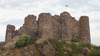
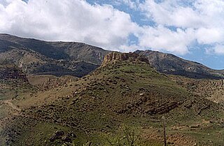
WAmberd is a 10th-century fortress located 2,300 meters (7,500 ft) above sea level, on the slopes of Mount Aragats at the confluence of the Arkashen and Amberd rivers in the province of Aragatsotn, Armenia. The name translates to "fortress in the clouds" in Armenian. It is also the name incorrectly attributed to Vahramashen Church, the 11th-century Armenian church near the castle. The village of Byurakan is 6.4 kilometres (4.0 mi) from the site of Amberd.
 W
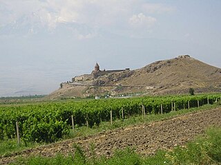
WAreni is a village in the Vayots Dzor Province of Armenia. It is best known for its wine production, although the majority of wine produced locally is from the nearby village of Getap. The church of S. Astvatsatsin is a single-nave two-aisled domed Armenian church completed in the year 1321, and is located atop a plateau overlooking the Arpa River and Areni. It was designed by the architect and sculptor Momik who is best known for his high-relief carvings at the monastery of Noravank. Nearby are also the 13th century ruins of lord Tarsaitch Orbelian of Syunik's palace, moved from Yeghegis to Areni during that time. Ruins of a 13th-century bridge built by Bishop Sarkis in 1265-1287 are one kilometer northeast of the church. At the same location are the remains of an older bridge.
 W
WThe Areni-1 cave complex is a multicomponent site, and late Chalcolithic/Early Bronze Age ritual site and settlement, located near the Areni village in southern Armenia along the Arpa River.
 W
WThe Areni-1 winery is a 6100-year-old winery that was discovered in 2007 in the Areni-1 cave complex in the village of Areni in the Vayots Dzor province of Armenia by a team of Armenian and Irish archaeologists. The excavations were carried out by Boris Gasparyan of the Institute of Archaeology and Ethnography of the National Academy of Sciences of Armenia and Ron Pinhasi from University College Cork (Ireland), and were sponsored by the Gfoeller Foundation (USA) and University College Cork. In 2008 the University of California, Los Angeles (UCLA) also joined the project with Gregory Areshian as co-director of the Areni Project. Since then the excavations have been sponsored by UCLA and the National Geographic Society as well. The excavations of the winery were completed in 2010.
 W
WArgishtikhinili was a town in the ancient kingdom of Urartu, established during the expansion of the Urartians in the Transcaucasus under their king Argishti I, and named in his honour. It lasted between the 8th and 6th centuries BC. The ruins of the Argishtikhinili fortifications are 15 kilometres (9 mi) southwest of the present-day town of Armavir, Armenia, between the villages of Nor-Armavir and Armavir in the Armenian marz of Armavir. The town was founded on the left bank of the middle reaches of the Aras River. Over the centuries, the river channel has shifted to several kilometres south of the town.
 W
WArmavir was a large commercial city and the capital of ancient Armenia during the reign of the Orontid Dynasty. It is located 1 km west of the 17th-century village of Armavir.
 W
WArtashat ; Hellenized as Artaxata and Artaxiasata, was a large commercial city and the capital of ancient Armenia during the reign of king Artaxias I; the founder of the Artaxiad Dynasty of the ancient Kingdom of Armenia. The name of the city is derived from Iranian languages and means the "joy of Arta". Founded by King Artaxias I in 176 BC, Artaxata served as the capital of the Kingdom of Armenia from 185 BC until 120 AD, and was known as the "Vostan Hayots".
 W
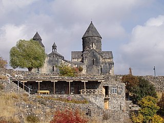
WAruchavank or the Cathedral of Aruch is situated on a rocky plateau at the western foot of Mount Aragats in the village of Aruch in the Aragatsotn Province of Armenia. According to wall inscriptions on the east wall and manuscripts written by historians Ghevond, Hovhannes Draskhanakerttsi, and Stepanos Asoghik, the church and adjoining building for residence were commissioned by Prince Grigor Mamikonian and his wife Heghine/Heline between 661-682 AD. Architecturally it is one of the most important Armenian churches of the Middle Ages and also one of the largest.
 W
WBaghaberd is a 4th to 12th century Armenian fortress located along a ridge overlooking the Voghji River, 14 kilometres (9 mi) northwest of the village of Kapan in the Syunik Province of Armenia. Baghaberd is at an elevation of 1,438 metres (4,718 ft).
 W
WBerdavan Castle is on a hilltop near the border with Azerbaijan, near the village of Berdavan in the Tavush Province of Armenia. Berdavan Castle is 664 metres (2,178 ft) above sea level.
 W
WBjni Fortress, is a medieval Armenian fortress located in the village of Bjni in the Kotayk Province of Armenia. It sits upon the top and along the sides of a mesa that divides the village nearly in half. The larger portion of which is located west of the mesa and curves south, while a smaller portion is east. The walls of the fortress may only be seen from the western side of the village, and are easiest reached via a narrow dirt road that forks and goes up the side of the hill past some residences. Bjni Fortress is 1,504 metres (4,934 ft) above sea level.
 W
WCarahunge, also called Zorats Karer, Karahunj, Qarahunj and Carenish, is a prehistoric archaeological site near the town of Sisian in the Syunik Province of Armenia. It is also often referred to in international tourist lore as the "Armenian Stonehenge".
 W
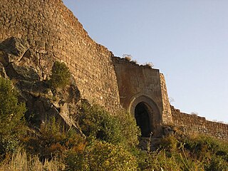
WDashtadem Fortress is a substantial fortress of the 10th to 19th centuries located at the southern outskirts of Dashtadem village in the Aragatsotn Province of Armenia. In a cemetery 1.7 km (1.1 mi) south of Dashtadem, lies the restored 7th-century Kristapori Vank which may be viewed in the distance from the fortress.
WErebuni Fortress, also known as Arin Berd, is an Urartian fortified city, located in Yerevan, Armenia. It is 1,017 metres (3,337 ft) above sea level. It was one of several fortresses built along the northern Urartian border and was one of the most important political, economic and cultural centers of the vast kingdom. The name Yerevan itself is derived from Erebuni.
 W
WErtij is a fort built during the 13th century. It is situated upon a hill adjacent to the village of Arpi in the Vayots Dzor Province of Armenia. Nearby in the gorge carved by the Arpa River is the cave shrine of Jrovank.
 W
WThe fortress of Halidzor is along a hill overlooking the Voghji River to the north, near the village of Kapan, which is 1 kilometre (0.6 mi) southwest in the Syunik Province of Armenia. Halidzor Fortress is 1,051 metres (3,448 ft) above sea level.
WHorom Citadel is an ancient Bronze Age through Urartian fortification atop two large hills south of the main road and opposite of the dam and Kamut Reservoir. It is about 1 kilometre (0.6 mi) east of the village of Horrom in the Shirak Province of northwestern Armenia. Not far from this location in Ghak and Shvaghtapa are two Urartian cyclopean forts.
 W
WKakavaberd or Kaqavaberd (Armenian: Կաքավաբերդ, Eastern Armenian Kak’avaberd; also known as Geghi Berd, Keghi Berd or Kegh is a fortress on a ridge overlooking the Azat River gorge at Khosrov Forest State Reserve in Ararat Province, Armenia. Kakavaberd is 1,516 metres above sea level.
WKarchaghbyur is a town in the Gegharkunik province of Armenia. A walled settlement abandoned in the 1st century BCE, of the Persian or Hellenistic period, is being excavated.
 W
WKhrber is situated in the mountains 8 kilometers south-east from the ruins of the fortified Urartian city of Teyseba, also known as Odzaberd and Ishkanaberd. Geographically it is located at the south-east corner of Lake Sevan, which can be seen in the distance at a highpoint amongst the ruins. The name is derived from the local dialect of the villages near south-east Lake Sevan and roughly translates to “ruins”. It was once the location of an ancient town, but now only its ruins remain. Foundations of large rectangular stone structures, portions of fortified thick walls, and a large cemetery with ancient tombs, headstones, and khachkars may still be seen. The majority of the oldest graves are located at the base of a hill just south of the ruins of Khrber. Within the ruins, there is a memorial of seven khachkars named Yot Verk Matur meaning "Seven Wounds Chapel". It is from approximately the 14th century and is dedicated to seven lords of seven villages that died during this time. Another more ancient cemetery lies beyond the large foothill just south of Khrber.
 W
WLori Fortress is an 11th-century Armenian fortress located near the Lori Berd village in Lori Province, Armenia. The fortress was built by David Anhoghin to become the capital of Kingdom of Tashir-Dzoraget in 1065.
 W
WMeghri Fortress, is an 11th-century Armenian fortress located in the town of Meghri, located on a hill overlooking the old section of the town from the north. Built in 1083, the fortress was founded during the 11th century and entirely rebuilt during the 18th century.
 W
WMetsamor site is the remains of an old fortress located to the southwest of the Armenian village of Taronik, in the Armavir Province.
WNor Geghi is a major village in the Kotayk Province of Armenia, located around 22 km north of the capital Yerevan, near the town of Nor Hachen. As of the 2011 census, the population of the village is 5,319.
 W
WOdzaberd is located upon a hill east of the town of Tsovinar and at the south-east corner of Lake Sevan in the Gegharkunik Province of Armenia. Odzaberd is situated at a height of 1,921 metres (6,302 ft).
 W
WProshaberd is a fortress built in the 13th century by Prince Prosh Khaghbakian. It is about 7 kilometres (4 mi) south of the town of Vernashen in the Vayots Dzor Province of Armenia. Almost one kilometer east is the 14th century Spitakavor Church dedicated to Saint Astvatsatsin.
WSardari Berd sits on the right before the cemetery in the village of Sardarapat in the Armavir Province of Armenia.
 W
WThe Shengavit Settlement is an archaeological site in present-day Yerevan, Armenia located on a hill south-east of Yerevan Lake. It was inhabited during a series of settlement phases from approximately 3000 BC cal to 2500 BC cal in the Kura Araxes (Shengavitian) Period of the Early Bronze Age and irregularly re-used in the Middle Bronze Age until 2200 BC cal. The town occupied an area of six hectares. It appears that Shengavit was a societal center for the areas surrounding the town due to its unusual size, evidence of surplus production of grains, and metallurgy, as well as its monumental 4 meter wide stone wall. Three smaller village sites of Moukhannat Tepe, Khorumbulagh, and Tairov have been identified and were located outside the walls of Shengavit. Its pottery makes it a type site of the Kura-Araxes or Early Transcaucasian Period and the Shengavitian culture area.
 W
WSmbataberd is a fortress located upon the crest of a hill between the villages of Artabuynk and Yeghegis in the Vayots Dzor Province of Armenia.
 W
WTegher Monastery is an early 13th-century Armenian monastery and church located on the southeastern slopes of Mount Aragats near the modern village of Tegher, and across the gorge from the village of Byurakan in the Aragatsotn Province of Armenia. It was built for Princess Khatun, the wife of Prince Vache I Vachutian who had purchased the district of Aragatzotn from the Zakarian brothers. The architect Vardapet Aghbayrik designed Tegher and the monasteries of Saghmosavank and Hovhannavank during the 13th century. The monastery survived intact during a time when Mongol invasions plagued the lands.
 W
WTeishebaini was the capital of the Transcaucasian provinces of the ancient kingdom of Urartu. It is located near the modern city of Yerevan in Armenia. The site was once a fortress and governmental centre with towered and buttressed perimeter walls, massive gates, a parade ground within its walls, and storage rooms that entirely occupied the ground floor. The site of the city, palace and citadel together measure over 0.45 km2. The name Karmir Blur translates to "Red Hill" because of the hill's reddish hue. It became this color after the city was set on fire and the upper walls which were made of tuff fell and crumbled because of the heat. After the tuff was heated by the fire, it took on a more intense red color and therefore the hill became red. The lower portions of the walls were left standing after the fire since they were built with a stronger stone. Teishebaini is situated at a height of 901 metres (2,956 ft).
 W
WThe Temple of Garni is the only standing Greco-Roman colonnaded building in Armenia and the former Soviet Union. Built in the Ionic order in the village of Garni, Armenia, it is the best-known structure and symbol of pre-Christian Armenia.
 W
WTsrviz Chapel or Moro-Dzoro, is a medieval Armenian chapel located near the village of Lusahovit in the Tavush Province of Armenia.
 W
WUshiberd is an Iron Age fortress located upon a hill just outside the village of Ushi in the Aragatsotn Province of Armenia. It has almost completely collapsed except for portions of the walls that once surrounded the fortress, located around the edge of the hill before it descends. Within the area that was once the interior of the fortress are large piles of large stones that once made up the fortification walls and structures within. Just below the hill is Saint Sargis Monastery of the 7th–13th centuries. It sits at the far side of what was once a settlement site from the 3rd–1st millennia BC. Nearby, down the main road that leads back into Ushi from the monastery and fortress, is a small chapel from the 10th century.
 W
WVorotnaberd is an important fortress along a ridge overlooking the Vorotan gorge, between the villages of Vaghatin and Vorotan in the Syunik Province of Armenia. Vorotnaberd is 1,365 metres (4,478 ft) above sea level.
 W
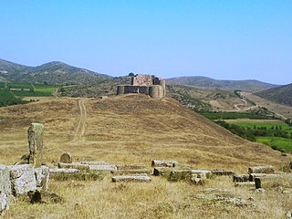
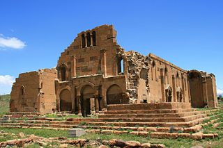
WYererouk, also Yereruyk or Ererouk, is an archeological site characterized by the presence of an ancient Armenian church near the village of Anipemza in the Shirak Province of Armenia. Yererouk was built on a plateau near the Akhurian River which defines the frontier with Turkey, about 5 km southeast of the ancient city of Ani.
 W
WYerevan is the capital and largest city of Armenia and one of the world's oldest continuously inhabited cities. Situated along the Hrazdan River, Yerevan is the administrative, cultural, and industrial center of the country. It has been the capital since 1918, the fourteenth in the history of Armenia and the seventh located in or around the Ararat plain. The city also serves as the seat of the Araratian Pontifical Diocese; the largest diocese of the Armenian Apostolic Church and one of the oldest dioceses in the world.
 W
WYot Verk Matur is a small monument erected around the late 14th-century in remembrance of seven lords of seven villages. Local folklore tells that when the Turko-Mongol conqueror Timur Lenk came into Armenia, he made war against the seven lords. As a result of the battles, the lords were killed and their villages were destroyed by Timur. Seven khachkars were placed in a row upon a low-rock wall enclosure as a memorial to the lords. The center khachkar dominates the others.
 W
WZvartnots Cathedral is a 7th-century centrally planned aisled tetraconch type Armenian cathedral built by the order of Catholicos Nerses the Builder from 643-652. Now in ruins, it is located at the edge of the city of Vagharshapat (Etchmiadzin) in Armavir Province of Armenia.