 W
WThe Trail of Tears was a series of forced relocations of approximately 60,000 Native Americans between 1830 and 1850 by the United States government. Members of the Cherokee, Muscogee (Creek), Seminole, Chickasaw, and Choctaw nations were forcibly removed from their ancestral homelands in the Southeastern United States to areas to the west of the Mississippi River that had been designated as 'Indian Territory'. The forced relocations were carried out by government authorities following the passage of the Indian Removal Act in 1830. The Cherokee removal in 1838 was brought on by the discovery of gold near Dahlonega, Georgia in 1828, resulting in the Georgia Gold Rush.
 W
WHighway 180 is a state highway of 1.65 miles (2.66 km) in Fayetteville. The route begins at Interstate 49/US 62/US 71/Highway 16 and runs east through Fayetteville to US 71 Business. Highway 180 is designated as part of the Trail of Tears National Historic Trail as well as Arkansas Heritage Trails System designations as the Butterfield Trail, Trail of Tears, and Civil War Trails.
 W
WAHighway 265 is a designation for three state highways in Northwest Arkansas. The southern segment of 19.70 miles (31.70 km) runs from Highway 170 near Strickler north to I-49/US 71/Highway 112 in south Fayetteville. A second segment begins in east Fayetteville at Highway 16 and runs north through Springdale to Highway 94 in Rogers. Further north, a third segment of 3.324 miles (5.349 km) runs from Highway 94 in Pea Ridge north to the Missouri state line. The highways are maintained by the Arkansas Department of Transportation (ARDOT).
 W
WBlue Spring Heritage Center is a 33-acre (13 ha) privately owned tourist attraction in the Arkansas Heritage Trails System containing native plants and hardwood trees in a setting of woodlands, meadows, and hillsides. It is located at Highway 62 West, five miles (8 km) west of Eureka Springs, Arkansas, and open daily to the public during warmer months for a fee.
 W
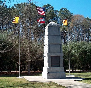
WBlythe Ferry was a ferry across the Tennessee River in Meigs County, Tennessee. In 1838, the ferry served as a gathering point and crossing for the Cherokee Removal, commonly called the Trail of Tears, in which thousands of Cherokee were forced to move west to Oklahoma from their homeland in the southeastern United States.
 W
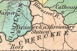
WThe Brainerd Mission was a Christian mission to the Cherokee in present-day Chattanooga, Tennessee. The associated Brainerd Mission Cemetery is the only part that still remains, and is listed on the National Register of Historic Places.
 W
WCadron Settlement Park is a 150-acre public park located in Conway, Arkansas. The park is operated by the city of Conway under a lease from the United States Army Corps of Engineers. It was established on October 14, 1979, and features a reconstructed blockhouse, a boat launching ramp, hiking trails, restrooms, picnic areas, pavilion, handicapped trails and parking areas, and interpretive signs. The Faulkner County Historical Society hosts public events in the blockhouse.
 W
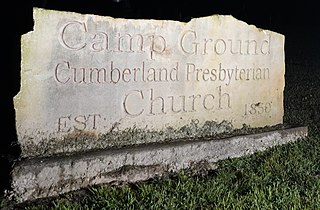
WThe Campground Church and Cemetery Site is a historic church and cemetery complex located at 50 Tunnel Lane near Anna, Illinois. The site began as a religious campground and local cemetery for the area's Presbyterian congregation; a church was added to the site in 1906. In 1838–39, when the Trail of Tears passed through Illinois, Cherokee who were removed from their homeland used the site as a campground. The campground included two springs, which were used as a source of fresh water for the Cherokee and their animals, and a gristmill run by local landowner George Hileman. In addition, several Cherokee children are buried in unmarked graves in the cemetery; the Trail of Tears was deadly for many of those who were forced to travel it, and children were among the most common victims. It is suspected that Hileman allowed the Cherokee to bury their dead in the local cemetery out of sympathy, as his own sons had died recently, though he may have also done so out of a sense of obligation toward fellow Christians.
 W
WThe Carrollton Road-Carrollton Segment is a historic 19th-century road in Boone County, Arkansas. It extends for more than 4 miles (6.4 km) eastward from Carrollton, which was once the county seat of Carroll County. The roadways matching the documented 1837 alignment of the road are County Road 417, Terrapin Creek Road, and Dunkard Road, up to its junction with Green Hill Road. This stretch of dirt road has retained a 19th-century rural character, and is further significant as a route taken by Native American parties on the Trail of Tears in 1838.
 W
WCherokee removal, part of the Trail of Tears, refers to the forced relocation between 1836 and 1839 of an estimated 16,000 members of the Cherokee Nation and 1,000-2,000 of their slaves; from their lands in Georgia, South Carolina, North Carolina, Tennessee, and Alabama to the Indian Territory in the then Western United States, and the resultant deaths along the way and at the end of the movement of an estimated 4,000 Cherokee and unknown number of slaves.
 W
WThe Chief Vann House is the first brick residence in the Cherokee Nation, and has been called the "Showplace of the Cherokee Nation". Owned by the Cherokee Chief James Vann, the Vann House is a Georgia Historic Site on the National Register of Historic Places and one of the oldest remaining structures in the northern third of the state of Georgia. It is located in Murray County, on the outskirts of Chatsworth in northwest Georgia, which has a commanding view of the land around it and of the Cohutta Mountains, about 10 miles (16 km) to the east.
 W
WChief White Eagle was a Native American politician and American civil rights leader who served as the hereditary chief of the Ponca from 1870 until 1904. His 34-year tenure as the Ponca head of state spanned the most consequential period of cultural and political change in their history, beginning with the unlawful Ponca Trail of Tears in 1877 and continuing through his successful effort to obtain justice for his people by utilizing the American media to wage a public relations campaign against the United States and President Rutherford B. Hayes. His advocacy against America's Indian removal policy following the Ponca Trail of Tears marked a shift in public opinion against the federal government's Indian policy that ended the policy of removal, placing him at the forefront of the nascent Native American civil rights movement in the second half of the 19th century.
 W
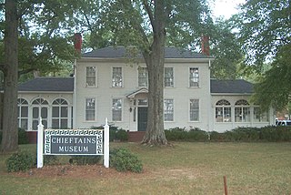
WChieftains Museum, also known as the Major Ridge Home, is a two-story white frame house built around a log house of 1792 in Cherokee country. It was the home of the Cherokee leader Major Ridge— notable for his role in negotiating and signing the Treaty of New Echota of 1835, which ceded the remainder of Cherokee lands in the Southeast to the United States. He was part of a minority group known as the Treaty Party, who believed that relocation was inevitable and wanted to negotiate the best deal with the United States for their people. The chiefs had agreed they could not go to war against the United States on the removal issue, but most other Cherokee opposed Ridge and the Treaty Party. He and some other members of the Treaty Party were murdered after removal to the Cherokee Nation in Indian Territory for having ceded the tribe's communal lands, as this was considered a capital crime.
 W
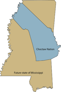
WThe Choctaw Trail of Tears was the attempted ethnic cleansing and relocation by the United States government of the Choctaw Nation from their country, referred to now as the Deep South, to lands west of the Mississippi River in Indian Territory in the 1830s by the United States government. A Choctaw miko (chief) was quoted by the Arkansas Gazette as saying that the removal was a "trail of tears and death." Since removal, the Choctaw have developed since the 20th century as three federally recognized tribes: the largest, the Choctaw Nation of Oklahoma; the Mississippi Band of Choctaw Indians, and the Jena Band of Choctaw Indians in Louisiana.
 W
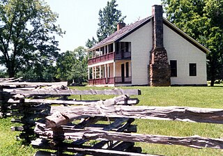
WThe Hair Conrad Cabin is a historic log cabin in Bradley County, Tennessee, United States, and the oldest residential structure in the county.
 W
WThe Dancing Rabbit Creek Treaty Site is a historic Choctaw Native American gathering place in rural Noxubee County, Mississippi. Located near a freshwater spring above the floodplain of Dancing Rabbit Creek in the southwestern part of the county, it was the site of a treaty negotiation between the Choctaw and the federal government in 1830, resulting in the Treaty of Dancing Rabbit Creek, in which the Choctaw agreed to surrender their ancestral lands for territory in what is now Oklahoma. It was the first treaty negotiated after passage of the Indian Removal Act, and served as a model for other treaties passed pursuant to that act. It also led to the Choctaw Trail of Tears. The site, now marked by a stone memorial and a small Choctaw cemetery, was designated a National Historic Landmark in 1996.
 W
WFort Mitchell Historic Site is a park and an archaeological site in Fort Mitchell, Alabama, that was declared a National Historic Landmark in 1990. The park features a reconstruction of the 1813 stockade fort that was an important United States military post in the Creek War, a museum with exhibits about the fort's history, and a collection of historic carriages, a restored 19th-century log home, and a visitor center.
 W
WFort Smith National Historic Site is a National Historic Site located in Fort Smith, Arkansas, along the Arkansas River. The first fort at this site was established by the United States in 1817, before this area was established as part of Indian Territory. It was later replaced and the second fort was operated by the US until 1871. This site was designated as a National Historic Landmark in 1961.
 W
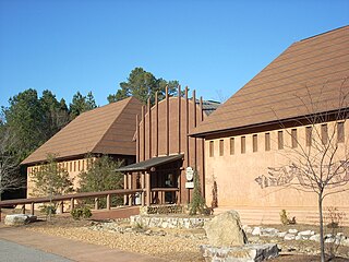
WThe Funk Heritage Center in Waleska, Georgia, is Georgia's official frontier and southeastern Indian interpretive center. Located on the campus of Reinhardt University, the center houses a gallery of Native American artifacts and artwork, as well as a theater, which features a short film on the history of Native Americans in the southeastern United States. A small souvenir shop is also available.
 W
WThe Henegar House is a historic house in Charleston, Tennessee. Constructed in 1849, it is the oldest remaining brick structure in Bradley County. It was listed on the National Register of Historic Places (NRHP) in 1976.
 W
WThe Indian Removal Act was signed into law on May 28, 1830, by United States President Andrew Jackson. The law authorized the president to negotiate with southern Native American tribes for their removal to federal territory west of the Mississippi River in exchange for white settlement of their ancestral lands. The act has been referred to as a unitary act of systematic genocide, because it discriminated against an ethnic group in so far as to make certain the death of vast numbers of its population. The Act was signed by Andrew Jackson and it was strongly enforced under his administration and that of Martin Van Buren, which extended until 1841.
 W
WThe John Bridges Tavern and Store Site is a historic tavern complex site located along Illinois Route 146 near Buncombe, Illinois. The tavern and store were built in the early 1830s by either John Bridges, Sr., or his son John Bridges, Jr. In 1838 and 1839, the Trail of Tears passed through southern Illinois, and the tavern and store served as a stopping place for Cherokee who had been removed from their homeland. Additionally, a spring on the property provided a water source for the Cherokee and their animals. The tavern burned down in 1940, and the complex has been partially demolished, but some remains of the store still stand and archaeological investigations have been conducted at the site.
 W
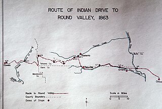
WThe Nome Cult Trail is a northern Californian historic trail located in present-day Mendocino National Forest which goes along Round Valley Road and through Rocky Ridge and the Sacramento Valley. It is also known as the Konkow Trail of Tears. On 28 August 1863 all Konkow Maidu were to be at the Bidwell Ranch in Chico to be taken to the Round Valley Reservation at Covelo in Mendocino County. Any Indians remaining in the area were to be shot. 435 Maidu were rounded up and marched under guard west out of the Sacramento Valley and through to the Coastal Range. 461 Native Americans started the trek, 277 finished. They reached Round Valley on 18 September 1863.
 W
WMoccasin Bend Archeological District is an archeological site in Chattanooga, Tennessee, that is part of the Chickamauga and Chattanooga National Military Park unit. The National Park Service refers to it as one of the "most unique units found in the entire National Park Service." The area contains remnants of 12,000 years of continuous human habitation and therefore serves as a fascinating area with a rich history and unique cultural significance. For many years, there was little recognition of the historical significance of the area, and years of industrial development occurred on and around sites of archeological importance. After decades of campaigning by concerned citizens, private organizations, local officials, the Friends of Moccasin Bend National Park, and finally a state representative, the area was officially recognized as a National Archeological District in 2003. Moccasin Bend is currently undergoing a process of renovation and restoration that will allow the area to fulfill the National Park Service's mission of preserving "natural and cultural resources" for the "enjoyment, education, and inspiration of this and future generations."
 W
WNeamathla was a leader of the Red Stick Creek (1750s–1841). His name, in the Hitchiti (Mikasuki) language, means "fat next to warrior", "fat" being a reference to great courage. The Hitchiti language had no written form, but modern scholars agree that Eneah Emathla is the "proper" spelling of his name in English; however, there were two other men also named Eneah Emathla, so the modern convention is to use the spelling Neamathla for the leader.
 W
WNew Echota was the capital of the Cherokee Nation in the Southeast United States from 1825 to their forced removal in the late 1830s. New Echota is located in present-day Gordon County, in northwest Georgia, 3.68 miles north of Calhoun, and south of Resaca next to present day New Town also called Ustanali. The site has been preserved as a state park and a historic site, and it was designated as a National Historic Landmark District in 1973.
 W
WThe Old Wire Road is a historic road in Missouri and Arkansas. Several local roads are still known by this name. It followed an old Native American route, the Great Osage Trail across the Ozarks and became a road along a telegraph line from St. Louis, Missouri, to Fort Smith, Arkansas. This route was also used by the Butterfield Overland Mail. It was known as the "Wire Road" while the telegraph line was up, but when the line was later removed, it simply became known as the "Old Wire Road". In St. Louis, where the road begins at Jefferson Barracks, it is called Telegraph Road. From St. Louis to Springfield, Missouri, it became designated Route 14.
 W
WPea Ridge National Military Park is a United States National Military Park located in northwest Arkansas near the Missouri border. The park protects the site of the Battle of Pea Ridge, fought March 7 and 8, 1862. The battle was a victory for the Union, and helped it gain control of the crucial border state of Missouri.
 W
WRattlesnake Springs is a historic site in Bradley County, Tennessee listed on the National Register of Historic Places (NRHP) in 1975.
 W
WRed Clay State Historic Park is a state park located in southern Bradley County, Tennessee established in 1979. The park is also listed as an interpretive center along the Cherokee Trail of Tears. It encompasses 263 acres (1.06 km2) of land and is located just above the Tennessee-Georgia stateline.
WReynoldsburg-Paris Road, in Benton County, Tennessee near Camden, Tennessee, was listed on the National Register of Historic Places in 2005. It runs through woodland within the Nathan Bedford Forrest State Park. It is a dirt-surfaced road about 10 to 18 feet wide.
 W
WRoss's Landing in Chattanooga, Tennessee, is the last site of the Cherokee's 61-year occupation of Chattanooga and is considered to be the embarkation point of the Cherokee removal on the Trail of Tears. Ross's Landing Riverfront Park memorializes the location, which is listed on the National Register of Historic Places.
 W
WThe Springfield to Fayetteville Road-Elkhorn Tavern Segment is a section of historic 19th-century roadway in Pea Ridge National Military Park in northwestern Arkansas. It is a dirt road, about 1 mile (1.6 km) long and 18 to 20 feet wide, that was built in 1835. The first major road through northwestern Arkansas, it connected Fayetteville, Arkansas with Springfield, Missouri. The road was part of the major northern route of the Trail of Tears, the forcible remove in the late 1830s of Native Americans from east of the Mississippi River to what is now Oklahoma. The road was also actively used by both Union and Confederate forces during the American Civil War, and was the major route of advance by Confederate forces leading to the Battle of Pea Ridge, whose battlefield is preserved by the park.
 W
WThlocklo Tustenuggee was one of the most prominent Seminole leaders in the Second Seminole War. He spoke English fluently, and also spoke Muscogee. Tustenuggee was one of the three leaders of the 300 Seminoles who fought in the battle that became known as the Dade Massacre. During the war, he and Halleck Tustenuggee, another prominent Seminole leader in the war, met with General Walker Keith Armistead to negotiate, but negotiations broke down and the war resumed. As the war waned, Armistead used money to bribe several Seminole leaders to surrender, but Tustenuggee refused to be bribed and he continued to lead his band in fighting. When the war ended, his Seminole band was one of the few that remained in Florida. In 1843, Tustenuggee and 26 of his followers were forcibly migrated from Florida to New Orleans, Louisiana. They were transported by the USS Lawrence along with 65 other Native Americans and three black slaves. Tustenuggee then committed suicide by swallowing powdered glass. His death was reported in newspapers, as were the deaths of other prominent Native American leaders who died in connection with the Trail of Tears.
 W
WTrail of Tears State Park is a public recreation area covering 3,415 acres (1,382 ha) bordering the Mississippi River in Cape Girardeau County, Missouri. The state park stands as a memorial to those Cherokee Native Americans who died on the Cherokee Trail of Tears. The park's interpretive center features exhibits about the Trail of Tears as well as displays and specimens of local wildlife. An archaeological site in the park was added to the National Register of Historic Places in 1970.
 W
WThe Treaty of Dancing Rabbit Creek was a treaty signed on September 27, 1830, and proclaimed on February 24, 1831, between the Choctaw American Indian tribe and the United States Government. This was the first removal treaty carried into effect under the Indian Removal Act. The treaty ceded about 11 million acres (45,000 km2) of the Choctaw Nation in what is now Mississippi in exchange for about 15 million acres (61,000 km2) in the Indian territory, now the state of Oklahoma. The principal Choctaw negotiators were Chief Greenwood LeFlore, Musholatubbee, and Nittucachee; the U.S. negotiators were Colonel John Coffee and Secretary of War John Eaton.
 W
WThe Treaty of New Echota was a treaty signed on December 29, 1835, in New Echota, Georgia, by officials of the United States government and representatives of a minority Cherokee political faction, the Treaty Party.
 W
WThe Treaty of Pontotoc Creek was a treaty signed on October 20, 1832 by representatives of the United States and the Chiefs of the Chickasaw Nation assembled at the National Council House on Pontotoc Creek, Mississippi. The treaty ceded the 6,283,804 million acres of the remaining Chickasaw homeland in Mississippi in return for Chickasaw relocation on an equal amount of land west of the Mississippi River.
 W
WUnto These Hills is an outdoor historical drama during summers at the 2,800-seat Mountainside Theatre in Cherokee in western North Carolina. It is the third-oldest outdoor historical drama in the United States, after The Lost Colony in Manteo in eastern North Carolina, and The Ramona Pageant in Southern California. The first version of the play was written by Kermit Hunter and opened on July 1, 1950, to wide acclaim.
 W
WWalk in My Soul is a 1985 historical novel by Lucia St. Clair Robson.