 W
WCarson Sink is a playa in the northeastern portion of the Carson Desert in present-day Nevada, United States of America, that was formerly the terminus of the Carson River. Today the sink is fed by drainage canals of the Truckee-Carson Irrigation District. The southeastern fringe of the sink, where the canals enter, is a wetland of the Central Basin and Range ecoregion.
 W
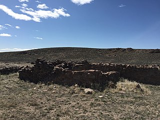
WCold Springs Pony Express Station Ruins, in Churchill County, Nevada near Frenchman, are the ruins of a Pony Express station built in 1860 or 1861. The ruins were listed as a 9.9-acre (4.0 ha) historic site on the National Register of Historic Places in 1972.
 W
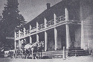
WCove Fort is a fort, unincorporated community, and historical site located in Millard County, Utah. It was founded in 1867 by Ira Hinckley at the request of Brigham Young. One of its distinctive features is the use of volcanic rock in the construction of the walls, rather than the wood used in many mid-19th-century western forts. This difference in construction is the reason it is one of very few forts of this period still surviving.
 W
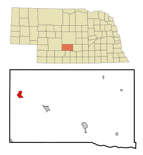
WCozad is a city in Dawson County, Nebraska, United States. The population was 3,977 at the 2010 census. The town is on the Great Plains of central Nebraska, along the Union Pacific Railroad and U.S. Route 30, just north of the Platte River. The 100th meridian, which roughly marks the eastward boundary of the arid plains, passes just west of the town as is marked nearby on a prominent sign across U.S. 30. In the early 1860s, the meridian was a stop along the Pony Express.
 W
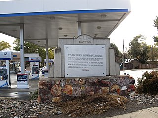
WDayton is an unincorporated community and census-designated place (CDP) in Lyon County, Nevada, United States. The population was 8,964 at the 2010 census. Dayton is the first Nevada settlement and home to the oldest hotel in Nevada. The micronation of Molossia is located in Dayton.
 W
WDobytown is a ghost town in Kearney County, Nebraska, United States, three miles west of Fort Kearny. Officially named Kearney City, the community was established in 1859. The town was given the common name of Dobytown because it contained mostly adobe buildings. Although the community no longer exists, the site was added to the National Register of Historic Places in 1974. The site is located at an altitude of 2,129 feet (649 m).
 W
WEightmile is a locale on the Goshute Indian Reservation in White Pine County, Nevada. It is located along Spring Creek.
 W
WElwood is a city in Doniphan County, Kansas, United States, located west across the Missouri River from Saint Joseph, Missouri. As of the 2010 census, the city population was 1,224.
 W
WEly is the largest city and county seat of White Pine County, Nevada, United States. Ely was founded as a stagecoach station along the Pony Express and Central Overland Route. In 1906 copper was discovered. Ely's mining boom came later than the other towns along US 50. The railroads connecting the transcontinental railroad to the mines in Austin, Nevada and Eureka, Nevada have long been removed, but the railroad to Ely is preserved as a heritage railway by the Nevada Northern Railway and known as the Ghost Train of Old Ely. As of the 2010 census, the population was 4,255.
 W
WFairfield is a town in Utah County, Utah, United States. It is part of the Provo–Orem, Utah Metropolitan Statistical Area. It is located in the southwest corner of Cedar Valley about 50 miles (80 km) southwest of Salt Lake City and 5 miles (8.0 km) south of Cedar Fort on Utah State Route 73, west of Utah Lake. The population was 119 at the 2010 census.
 W
WFairview is a ghost town in Churchill County, Nevada, in the United States of America.
 W
WFort Caspar was a military post of the United States Army in present-day Wyoming, named after 2nd Lieutenant Caspar Collins, a U.S. Army officer who was killed in the 1865 Battle of the Platte Bridge Station against the Lakota and Cheyenne. Founded in 1859 along the banks of the North Platte River as a trading post and toll bridge on the Oregon Trail, the post was later taken over by the Army and named Platte Bridge Station to protect emigrants and the telegraph line against raids from Lakota and Cheyenne in the ongoing wars between those nations and the United States. The site of the fort, near the intersection of 13th Street and Wyoming Boulevard in Casper, Wyoming, is listed in the National Register of Historic Places and is now owned and operated by the City of Casper as the Fort Caspar Museum and Historic Site.
 W
WFort Churchill State Historic Park is a state park of Nevada, United States, preserving the remains of a United States Army fort and a waystation on the Pony Express and Central Overland Routes dating back to the 1860s. The site is one end of the historic Fort Churchill and Sand Springs Toll Road. The park is in Lyon County south of the town of Silver Springs, on U.S. Route 95 Alternate, eight miles (13 km) south of U.S. Route 50. Fort Churchill was designated a National Historic Landmark in 1961. A 1994 park addition forms a corridor along the Carson River.
 W
WFort Laramie was a significant 19th-century trading post, diplomatic site, and military installation located at the confluence of the Laramie and the North Platte rivers. They joined in the upper Platte River Valley in the eastern part of the U.S. state of Wyoming. The fort was founded as a private trading post in the 1830s to service the overland fur trade; in 1849, it was purchased by the United States Army. It was located east of the long climb leading to the best and lowest crossing point of the Rocky Mountains at South Pass and became a popular stopping point for migrants on the Oregon Trail. Along with Bent's Fort on the Arkansas River, the trading post and its supporting industries and businesses were the most significant economic hub of commerce in the region.
 W
WFort Ruby, also known as Camp Ruby, was built in 1862 by the United States Army, during the American Civil War, in the "wilderness of eastern Nevada." It protected the overland mail coaches and Pony Express, in order to maintain links and communication between residents of California and the Union. It was operated 1862 to 1869, in territory dominated by bands of the Western Shoshone. The fort was located at the east entrance to the Overland Pass from Ruby Valley, near Hobson on the west side of Ruby Lake.
 W
WFountain Place is an unincorporated community in El Dorado County, California. It lies at an elevation of 7785 feet. It was a station for the Pony Express that was between Woodford's Station and Yank's Station.
 W
WFriday's Station, on US 50 between Kingsbury Grade and Loop Road in Stateline, Nevada, is a two-story wood-frame white building built as a Pony Express station and inn in 1860. In 1986, it was known as Park Cattle Company Residence and was listed on the National Register of Historic Places. The two-story wood-frame white building is visible from U.S. Route 50 near the California-Nevada border at Stateline, Nevada.
WFriday's Station, on US 50 between Kingsbury Grade and Loop Road in Stateline, Nevada, is a two-story wood-frame white building built as a Pony Express station and inn in 1860. In 1986, it was known as Park Cattle Company Residence and was listed on the National Register of Historic Places. The two-story wood-frame white building is visible from U.S. Route 50 near the California-Nevada border at Stateline, Nevada.
 W
WGandy is a unincorporated community in the northwestern corner of Millard County, Utah, United States, located just east of the Nevada-Utah state line.
 W
WGenoa is an unincorporated town in Douglas County, Nevada, United States. Founded in 1851, it was the second settlement in what became the Nevada Territory. It is situated within Carson River Valley and is approximately 42 miles (68 km) south of Reno at 39.005,-119.846. The population was 939 at the 2010 census. It is home to the third oldest bar in the state of Nevada which opened in 1853.
 W
WGothenburg is a city in Dawson County, Nebraska, United States. It is part of the Lexington, Nebraska Micropolitan Statistical Area. The population was 3,574 at the 2010 census.
 W
WThe Hollenberg Pony Express Station, also known as Cottonwood Pony Express Station, is the most intact surviving station of the Pony Express in the United States. It was built by Gerat H. Hollenberg in 1858, to serve travelers on the Oregon and California Trails, and was used by the Pony Express when it was established in 1860. The station is owned by the state of Kansas and is operated by the Kansas Historical Society as Hollenberg Pony Express Station State Historic Site. It was designated a National Historic Landmark in 1961.
 W
WHot Springs Hotel and Brewery was a Utah Pony Express station, inn and brewery founded in 1856 by Porter Rockwell at Point of the Mountain, modern-day Bluffdale, Utah. It was a contract Pony Express station, ten miles south of Trader's Rest station. Rockwell is known historically as the bodyguard of early Mormon leader and Utah settler Brigham Young. The brewery was Utah's first and at its peak made 500 gallons of beer a day.
 W
WIbapah is a small unincorporated community in far western Tooele County, Utah, United States, near the Nevada state line.
 W
WJulesburg is the statutory town that is the county seat and the most populous municipality of Sedgwick County, Colorado, United States. The population was 1,225 at the 2010 United States Census. It is close to the Nebraska border.
 W
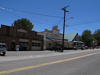
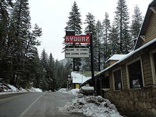
WKyburz is a small unincorporated community in El Dorado County, California. It is located along the South Fork of the American River and U.S. Route 50, and is surrounded by the Eldorado National Forest. Its elevation is 4058 feet above sea level.
WLake Valley is an unincorporated community in El Dorado County, California. It extends for 8 miles (13 km) along the Upper Truckee River from Lake Tahoe to Meyers, at an elevation of 6207 feet.
 W
WLexington is a city in Dawson County, Nebraska, United States. The population was 10,230 at the 2010 census. It is the county seat of Dawson County. Lexington is located in southern Nebraska, on the Platte River, southeast of North Platte. It sits along the route of U.S. Route 30 and the Union Pacific Railroad. In the 1860s, Lexington was the location of a stop along the Pony Express.
 W
WMartinez is a city in and the county seat of Contra Costa County, California, in the East Bay of the San Francisco Bay Area. The population was 35,824 at the 2010 census. The downtown is notable for its large number of preserved old buildings and antique shops. Martinez is located on the southern shore of the Carquinez Strait in the San Francisco Bay Area, directly facing the city center of Benicia and the southeastern end of Vallejo, California.
 W
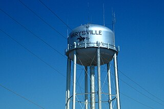
WMarysville is a city in and the county seat of Marshall County, Kansas, United States. As of the 2010 census, the city population was 3,294.
 W
WMeyers is a small unincorporated community in El Dorado County, California, United States, along U.S. Route 50 in the northern Sierra Nevada. It is 6 miles (10 km) south of South Lake Tahoe in the Lake Tahoe area and lies at an elevation of 6,352 feet. Established in 1851, Meyers started out as a stagecoach stop, trading post and Pony Express station. The town is now registered as California Historical Landmark #708. It serves as a popular stop on the way into and out of the Tahoe Basin for travelers on Highways 50 and 89.
 W
WMound House is a small unincorporated community in Lyon County, Nevada on U.S. Route 50 that is situated between Nevada's capital, Carson City, and Dayton. Its elevation is 4,974 feet (1,516 m). It is in Lyon County, one of eight Nevada counties that allow for legalized prostitution, and is home to four brothels.
 W
WMurray is a city situated on the Wasatch Front in the core of Salt Lake Valley in the U.S. state of Utah. Named for territorial governor Eli Murray, it is the state's fourteenth largest city. According to the 2010 census, Murray has approximately 46,746 residents. Murray shares borders with Taylorsville, Holladay, South Salt Lake and West Jordan, Utah. Once teeming with heavy industry, Murray's industrial sector now has little trace and has been replaced by major mercantile sectors. Known for its central location in Salt Lake County, Murray has been called the Hub of Salt Lake County. Unlike most of its neighboring communities, Murray operates its own police, fire, power, water, library, and parks and recreation departments and has its own school district. While maintaining many of its own services, Murray has one of the lowest city tax rates in the state.
 W
WOgallala is a city in and the county seat of Keith County, Nebraska, United States. The population was 4,737 at the 2010 census. In the days of the Nebraska Territory, the city was a stop on the Pony Express and later along the transcontinental railroad. The Ogallala Aquifer was named after the city.
 W
WPacheco is a census-designated place (CDP) in Contra Costa County, California, United States, in the San Francisco Bay Area. The population was 3,685 at the 2010 census. It is located 5.5 miles north of Walnut Creek, 19 miles (31 km) miles northeast of Oakland, California, and 27 miles (43 km) miles northeast of San Francisco.
 W
WPlacerville is a city in and the county seat of El Dorado County, California. The population was 10,389 at the 2010 census, up from 9,610 at the 2000 census. It is part of the Sacramento–Arden-Arcade–Roseville Metropolitan Statistical Area.
 W
WPoint of Rocks is an unincorporated community in Sweetwater County, Wyoming, United States. As of the 2000 census, Point of Rocks had a total population of three, when it was a census-designated place (CDP).
 W
WThe Pony Express Bible is a Protestant Bible that was distributed to the Pony Express riders in 1860 and 1861.
 W
WThe Reese River is a 181-mile-long (291 km) tributary of the Humboldt River, located in central Nevada in the western United States.
 W
WRock Creek Station was a stagecoach and Pony Express station in southeastern Nebraska, three miles northeast of the present-day village of Endicott. The site is preserved as Rock Creek Station State Historical Park.
 W
WThe Ruby Valley Pony Express Station, located at 1515 Idaho St. in Elko, Nevada, was built in 1860 in Ruby Valley, Nevada. It was moved in 1960 approximately 60 miles (97 km) to Elko, during the centennial anniversary year for the Pony Express, and then restored, and is listed on the National Register of Historic Places. The building is significant as one of only two surviving Pony Express buildings in Nevada, out of 43 stations in Nevada.
 W
WThe Sand Springs Station is a historic site in Churchill County, Nevada that was listed on the National Register of Historic Places in 1980. A Pony Express station existed there in 1860. The ruins are located within the boundaries of the Sand Mountain Recreation Area.
 W
WSchellbourne, formerly known as Fort Schellbourne and Schell Creek Station is an unincorporated community located in White Pine County in Nevada, United States, located 43 miles (69 km) north of Ely. The town was a stopover along the Central Overland Route, Pony Express and original routing of the Lincoln Highway. It is today Nevada Historical Marker number 51. The site was listed on the National Register of Historic Places in 1972. Its boundaries were increased in 1977.
 W
WSimpson Park is a valley south of Grass Valley, Nevada that contained a Pony Express station location of Pony Express Division Four.
WStagecoach is an unincorporated community and census-designated place (CDP) in Lyon County, Nevada, United States, located east of Reno. Its name is likely derived from its place as the Overland Stagecoach station at Desert Well. Typically, the mail that was heading towards California was delivered on a steamship through Panama. But in 1857, the Overland mail company was created, and the Desert Well station was a dual stop for both the stagecoach line and the Pony Express.
WStillwater is a 19th-century ghost town of Churchill County, Nevada. Stillwater became the county seat of Churchill County in 1868, when the town was an important mail stage stop. In 1903 the seat of government moved to Fallon, Nevada.
 W
WStrawberry is a small unincorporated community on the South Fork American River, 3.25 miles (5 km) south-southwest of Pyramid Peak, along U.S. Route 50 in the foothills of the Sierra Nevada. The sign on the highway reads population 50.