 W
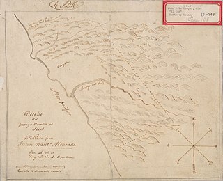
WRancho Las Camaritas was an Alta California 18.57 acres land grant to José de Jesús Noé on January 21, 1840 by Governor Juan Bautista Alvarado. Millions of acres of California land was given at no charge to men between 1784–1846 by the Spanish (1784–1810) or Mexican governments (1819–1846) mostly for military service to raise cattle on. About 300 of the 800 Land grants were sizable varying from a few thousand to 1.5 million acres – see List of ranchos of California for the larger grants. Following the Mexican–American War, the land grants were challenged with most of them falling into American hands. Only one land grant has remained undeveloped. Las Camaritas' ownership was disputed in court by the U.S. government from 1856 until 1882 due to conflicting documentation presented by its American owner Ferdinand Vassault after a string of sales initiated by Jose Noe sometime between 1842–46.
 W
WRancho Aguaje de la Centinela was a 2,219-acre (8.98 km2) Mexican land grant in present-day Los Angeles County, California given in 1837 to Ygnacio Machado. The name means "Sentinel of Waters" in Spanish, and refers to the artesian water in the area exemplified by Centinela Springs. Rancho Aguaje de la Centinela included parts of present-day Westchester and Inglewood.
 W
WRancho Los Alamitos takes its name from an 1834 Mexican partition of the 1784 Rancho Los Nietos, a Spanish concession, covering an area in present-day California's southwestern Los Angeles County and northwestern Orange County. Los Alamitos means the Little Cottonwoods or Poplars in Spanish, after the native Fremont Cottonwood trees there.
 W
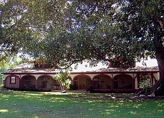
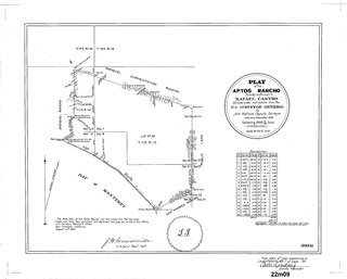
WRancho Aptos was a 6,686-acre (27.06 km2) Mexican land grant in present day Santa Cruz County, California given in 1833 by Governor José Figueroa to Rafael Castro. The grant on the Monterey Bay was immediately downcoast of his sister, Martina Castro's Rancho Soquel, and upcoast of his father, José Joaquín Castro's Rancho San Andrés. Rancho Aptos went from Seacliff State Beach to Rio del Mar and included present day Aptos.
 W
WRancho Arroyo de Las Nueces y Bolbones was a 17,782-acre (71.96 km2) Mexican land grant in present-day Contra Costa County, California given in 1834 by Governor José Figueroa to Juana Sanchez de Pacheco.
 W
WRancho Bodega was a 35,487-acre (143.61 km2) Mexican land grant in present day Sonoma County, California given in 1844 by Governor Manuel Micheltorena to Stephen Smith. Bodega takes its name from the Peruvian explorer Juan Francisco de la Bodega y Quadra who discovered Bodega Bay in 1775. The grant extended along the Pacific coast from the Russian River on the north to Estero Americano on the south, and included the present-day town of Bodega Bay. Only a small part of Bodega is within the grant.
 W
WRancho La Bolsa Chica was an 8,107-acre (32.81 km2) Mexican land grant in present day coastal northwestern Orange County, California given in 1841 by Governor Juan Alvarado to Joaquín Ruiz. The name means "little pocket", and refers to pockets of land amongst the marsh wetlands of the Santa Ana River estuary. The rancho lands include the present day city of Huntington Beach, the community of Sunset Beach, and the significant Bolsa Chica Ecological Reserve.
 W
WRancho La Brea was a 4,439-acre (17.96 km2) Mexican land grant in present-day Los Angeles County, California, given in 1828 to Antonio Jose Rocha and Nemisio Dominguez by José Antonio Carrillo, the alcalde of Los Angeles. Rancho La Brea consisted of one square league of land of what is now Wilshire's Miracle Mile, Hollywood, and parts of West Hollywood. The grant included the famous La Brea Tar Pits.
 W
WRancho Butano was a 4,439-acre (17.96 km2) Mexican land grant in present-day San Mateo County, California given in 1838 by Governor Juan Alvarado and confirmed in 1844 by Governor Manuel Micheltorena to Ramona Sanchez. The name Butano can be traced back to 1816. It speculated that Californios called a drinking cup made from the horn of a bull or other animal a butano. A First American origin is possible but has not been established. At one time, the grant was in Santa Cruz County 1850-1868; a boundary adjustment transferred the land to San Mateo County. The grant extended along the Pacific coast between Rancho Pescadero and Rancho Punta del Año Nuevo, with Butano Creek on the north to Arroyo de los Frijoles on the south, and encompassed present-day Bean Hollow State Beach and Butano State Park.
 W
WRancho Cahuenga was a 388-acre (1.57 km2) Mexican land grant in the San Fernando Valley, in present-day Los Angeles County, California given in 1843 by governor Manuel Micheltorena to José Miguel Triunfo. Rancho Cahuenga is now a part of the city of Burbank, with the Los Angeles River channel running through it. Rancho Cahuenga is often confused with the nearby Campo de Cahuenga, near what is now Universal City, where in 1847 the Articles of Capitulation were signed, ending the Mexican-American War in Alta California.
 W
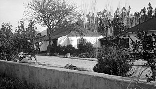
WRancho Camulos, now known as Rancho Camulos Museum, is a ranch located in the Santa Clara River Valley 2.2 miles (3.5 km) east of Piru, California and just north of the Santa Clara River, in Ventura County, California. It was the home of Ygnacio del Valle, a Californio alcalde of the Pueblo de Los Angeles in the 19th century and later elected member of the California State Assembly. The ranch was known as the Home of Ramona because it was widely believed to have been the setting of the popular 1884 novel Ramona by Helen Hunt Jackson. The novel helped to raise awareness about the Californio lifestyle and romanticized "the mission and rancho era of California history."
 W
WRancho Cañada de los Osos y Pecho y Islay was a 32,431-acre (131.24 km2) Mexican land grant in Los Osos Valley and the southern Estero Bay headlands, in present-day San Luis Obispo County, California.
 W
WRancho Cañada de San Miguelito was a 8,877-acre (35.92 km2) Mexican land grant in present-day Ventura County, California, given in 1846 by Governor Pío Pico to Ramón Rodríguez. The name means valley of San Miguelito. The grant extended between the Pacific coast and the west bank of the Ventura River. On the east bank of the Ventura River was Rancho Cañada Larga o Verde and to the south was Rancho San Miguel, Rancho Ex-Mission San Buenaventura, and present day Ventura.
 W
WRancho Cañada del Corte de Madera was a 3,566-acre (14.43 km2) Mexican land grant in present day Santa Clara County, California given in 1833 by Governor José Figueroa to José Domingo Peralta and Máximo Martínez. The name translates as "the valley where lumber is cut". The grant was located west of today's I-280, and south of San Francisquito Creek near Searsville Lake, and covered most of the Portola Valley.
 W
WRancho Cañada Larga o Verde was a 6,659-acre (26.95 km2) Mexican land grant in present day Ventura County, California given in 1841 by Governor Juan B. Alvarado to Joaquina Alvarado. The grant extended along Sulphur Canyon Creek, east of the Ventura River, between Ventura and Ojai. To the west, across the Ventura River was Rancho Cañada de San Miguelito; to the north Rancho Ojai; and to the south and east Rancho Ex-Mission San Buenaventura.
 W
WRancho Corral de Piedra was a 30,911-acre (125.09 km2) Mexican land grant in present day San Luis Obispo County, California consisting of two square leagues given in 1841 by Governor Juan B. Alvarado to José María Villavicencio, with an extension of five square leagues given in 1846, by Governor Pio Pico. The grant was located between present day San Luis Obispo and Arroyo Grande, and bounded on the south by Arroyo Grande Creek.
WRancho el Corte de Madera was a 13,316-acre (53.89 km2) Mexican land grant in present day Santa Clara County, California given in 1844 by Governor Manuel Micheltorena to Máximo Martínez. The name translates as "the place where lumber is cut". The roughly triangular shaped grant was west of today's I-280, and bounded on the north by Alambique Creek and San Francisquito Creek, on the south by Los Trancos Creek and Matadero Creek, and on the west by what is now Skyline Boulevard. The grant surrounded Rancho Cañada del Corte de Madera which extended along the Portola Valley. The land grant included parts of present day Woodside, Ladera and Stanford University.
 W
WRancho Cucamonga was a 13,045-acre (52.79 km2) Mexican land grant in present-day San Bernardino County, California, given in 1839 to the dedicated soldier, smuggler and politician Tiburcio Tapia by Mexican governor Juan Bautista Alvarado. The grant formed parts of present-day Rancho Cucamonga and Upland. It extended easterly from San Antonio Creek to what is now Hermosa Avenue, and from today's Eighth Street to the mountains.
 W
WTapia Adobe was the home of Tiburcio Tapia (1789–1845). Tiburcio Tapia was a Mexican soldier, politician, then became a merchant, winery owner and ranch owner, in what is now Cucamonga, California. The place of Tapia Adobe (home) was designated a California Historic Landmark (No.360) on October 9, 1939. Tiburcio Tapía received the land to built his Adobe and Rancho Cucamonga from a 1839 13,045-acre (52.79 km2) Mexican land grant in present-day San Bernardino County, California The land grant was from Mexican governor Juan Bautista Alvarado. The grant formed parts of present-day Rancho Cucamonga and Upland. It extended easterly from San Antonio Creek to what is now Hermosa Avenue, and from today's Eighth Street to the mountains.
 W
WRancho El Sur was a 8,949.06-acre (36.22 km2) Mexican land grant in present-day Monterey County, California on the Big Sur coast given in 1834 by Governor José Figueroa to Juan Bautista Alvarado. The grant extended from the mouth of Little Sur River inland about 2.5 miles (4.0 km) over the coastal mountains and south along the coast past the mouth of the Big Sur River to Cooper's Point. In about 1892, the rancho land plus an additional 3,000 acres (1,200 ha) of resale homestead land was divided into two major parcels. The southern 4,800 acres (1,900 ha) became the Molera Ranch, later the foundation of Andrew Molera State Park. The northern 7,100 acres (2,900 ha) formed the El Sur Ranch.
 W
WRancho Los Encinos was a Spanish grazing concession, and later Mexican land granted cattle and sheep rancho and travelers way-station on the El Camino Real in the San Fernando Valley, in present-day Encino, Los Angeles County, California. The original 19th-century adobe and limestone structures and natural warm springs are now within the Los Encinos State Historic Park.
 W
WRancho Feliz was a 4,448-acre (18.00 km2) Mexican land grant in present day San Mateo County, California given in 30 April 1844 by Governor Manuel Micheltorena to Domingo Féliz. The grant extended north from Rancho Cañada de Raymundo along the San Andreas Valley, west of San Andreas Lake up to Sweeney Ridge.
 W
WRancho Los Feliz was a 6,647-acre (26.90 km2) Spanish land concession in present-day Los Angeles County, California given in 1795 by Spanish Governor Pedro Fages to José Vicente Feliz. The land of the grant includes Los Feliz and Griffith Park, and was bounded on the east by the Los Angeles River.
 W
WRancho Guadalasca was a 30,594-acre (123.81 km2) Mexican land grant in present-day Ventura County, California given in 1836 by Governor Mariano Chico to Ysabel Yorba. The grant was in the southern part of the county, bordering on Los Angeles County. The grant extended along the Pacific coast near Point Mugu for about eight miles, and extending into the interior along Guadalasca Creek in the Santa Monica Mountains for about ten miles.
 W
WRancho Guajome was a 2,219-acre (8.98 km2) Mexican land grant in present-day San Diego County, California given in 1845 by Governor Pío Pico to Andrés and José Manuel, Indians. The name comes from a Luiseño phrase involving the word "frog", likely wakhavumi "frog pond" or waxáawu-may "little frog". The grant was south of San Luis Rey River and Rancho Monserate and north of present-day Vista. The site is now registered as California Historical Landmark #940.
 W
WGualala is an unincorporated community in Mendocino County in the U.S. state of California. It is located north of The Sea Ranch and south of Point Arena, California. Gualala shares its southern border with the southern border of Mendocino County. It is located on the Pacific coast at the mouth of the Gualala River, on State Route 1. It serves as a commercial center for the surrounding area. Gualala was once a logging town, but tourism is now its central economic activity.
 W
WRancho Milpitas was a 4,458-acre (18.04 km2) Mexican land grant in Santa Clara County, California. The name comes from the Nahuatl word for maize and could be translated "little cornfields". The grant included what is now the city of Milpitas.
 W
WRancho Moro y Cayucos was a 8,045-acre (32.56 km2) Mexican land grant in present-day San Luis Obispo County, California given in 1842 by Governor Juan B. Alvarado to Martin Olivera and Vicente Feliz (Felis). The grant extended along the Pacific Coast from just north of present-day Cayucos south to Moro Creek just north of present-day Moro Bay.
WRancho Nipomo was a 37,888-acre (153.33 km2) Mexican land grant in present day San Luis Obispo County, California given in 1837 by Governor Juan B. Alvarado to William Goodwin Dana. The grant encompassed present day Nipomo. The ranch is designated as a California Historical Landmark.
 W
WRancho Olompali was a 8,877-acre (35.92 km2) Mexican land grant in present-day Marin County, California given in 1834 by governor Manuel Micheltorena to Camilo Ynitia, son of a Coast Miwok chief. The name Olómpali comes from the Coast Miwok language and likely means southern village or southern people. The land grant is between present-day Novato and Petaluma. A part of this land now comprises the Olompali State Historic Park.
 W
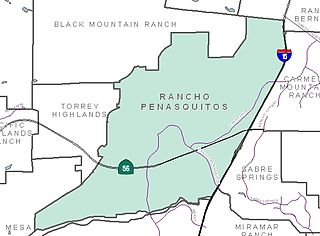
WRancho Peñasquitos is a suburban community in the northeastern part of the city of San Diego, California. It is named after the first Mexican land grant in the county, Rancho Santa Maria de Los Peñasquitos. Peñasquitos means "little cliffs" in Spanish. It abuts Los Peñasquitos Canyon Preserve, an open space preserve that offers hiking, biking, and equestrian trails. The community is commonly abbreviated "PQ."
 W
WRancho Petaluma Adobe is a historic ranch house in Sonoma County, California. It was built from adobe bricks in 1836 by order of Mariano Guadalupe Vallejo. It was the largest privately owned adobe structure built in California and is the largest example of the Monterey Colonial style of architecture in the United States. A section of the former ranch has been preserved by the Petaluma Adobe State Historic Park and it is both a California Historic Landmark and a National Historic Landmark. The Rancho Petaluma Adobe State Historic Park is located on Adobe Road on the east side of the present-day town of Petaluma, California.
 W
WRancho Piedra Blanca was a large, 48,806-acre (197.51 km2) Mexican land grant in present-day San Luis Obispo County, California given in 1840 by Governor Juan Alvarado to José de Jesús Pico. The name means "white rock" and refers to rocks painted white by its bird population. The grant extended south along the Pacific Coast below Big Sur from Ragged Point to Pico Creek, where it adjoins Rancho San Simeon. The land grant includes the original townsite and post office for San Simeon, the Hearst Ranch headquarters, and Hearst Castle.
 W
WRancho Potrero Y Rincon de San Pedro Regalado was one of the smallest Mexican land grants in Alta California. Unlike the huge ranchos comprising tens of thousands of acres, this one was only 500 varas by 600 varas of the pasture land (potrero) originally belonging to Mission Santa Cruz.
 W
WRancho de las Pulgas was a 35,240-acre (142.6 km2) 1795 Spanish land grant in present-day San Mateo County, California to José Darío Argüello. The literal translation is "Ranch of the Fleas", probably named after a village of the local Lamchin people. The grant was bounded by San Mateo Creek on the north and San Francisquito Creek on the south, and extended about one league from San Francisco Bay to the hills. The grant encompassed present-day San Mateo, Belmont, San Carlos, Redwood City, Atherton and Menlo Park.
 W
WRancho Punta del Año Nuevo was a 17,753-acre (71.84 km2) Mexican land grant in present day San Mateo County, California given in 1842 by Governor Juan B. Alvarado to Simeon Castro. At the time, the grant was in Santa Cruz County; an 1868 boundary adjustment gave the land to San Mateo County. The grant extended along the Pacific coast from Rancho Butano and Arroyo de los Frijoles on the north, past Pigeon Point, Franklin Point to Point Año Nuevo on the south.
 W
WRancho Rincon de Musalacon was a 8,867-acre (35.88 km2) Mexican land grant in present-day Sonoma County, California given in 1846 by Governor Pío Pico to Francisco Berreyesa. The grant extended along both sides of the Russian River and encompassed present-day Cloverdale and Asti.
 W
WRancho El Rio de Santa Clara o la Colonia was a 44,883-acre (181.64 km2) Mexican land grant in present-day Ventura County, California given in 1837 by Governor Juan B. Alvarado to Valentine Cota et al. The grant extended from the Santa Clara River south to the present-day Point Mugu Naval Air Station, and the boundary of Rancho Guadalasca, and east from the Pacific Ocean to the present-day 101 Freeway, and the boundary of Rancho Santa Clara del Norte. The grant encompassed present-day Colonia and Oxnard.
 W
WRancho Roblar de la Miseria was a 16,887-acre (68.34 km2) Mexican land grant in present-day Sonoma County, California given in 1845 by Governor Pío Pico to Juan Nepomuceno Padilla. "El Roblar de la Miseria" means "The Oak of the Misery". The grant extended along the Petaluma River from Hessel, Roblar, Liberty and Two Rock south to Petaluma.
 W
WRancho Rodeo de las Aguas was a 4,539-acre (18.37 km2) land grant in present day Beverly Hills, Los Angeles County, California given to María Rita Quinteros Valdez de Villa in 1838.
 W
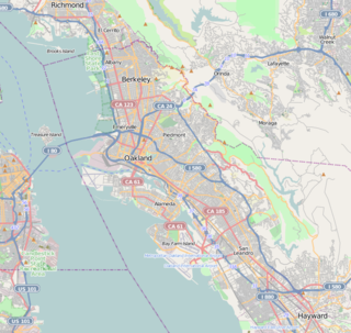
WRancho San Antonio, also known as the Peralta Grant, was a 44,800-acre (181 km2) land grant by Governor Pablo Vicente de Solá, the last Spanish governor of California, to Don Luís María Peralta, a sergeant in the Spanish Army and later, commissioner of the Pueblo of San José, in recognition of his forty years of service. The grant, issued on August 3, 1820, embraced the sites of the cities of San Leandro, Oakland, Alameda, Emeryville, Piedmont, Berkeley, and Albany.
 W
WRancho San Francisco was a land grant in present-day northwestern Los Angeles County and eastern Ventura County, California. It was a grant of 48,612 acres (19,673 ha) by Governor Juan B. Alvarado to Antonio del Valle, a Mexican army officer, in recognition for his service to Alta California. It is not related to the city of San Francisco.
 W
WRancho San Geronimo was a 8,893-acre (35.99 km2) Mexican land grant in present-day San Luis Obispo County, California given in 1842 by Governor Juan Alvarado to Rafael Villavicencio. The granted extended along the Pacific coast from south of present-day Harmony to north of Cayucos. Villa Creek, which retains the Villavicencio name, runs through the center of the grant. Rancho Geronimo adjoined Rancho Moro y Cayucos, down coast to the southeast.
 W
WRancho San Jose de Buenos Ayres was a 4,438-acre (17.96 km2) Mexican land grant in present day Los Angeles County, California given by Governor Micheltorena in 1843 to Maximo Alanis. The area that was given to Alanis now occupies Westwood, UCLA, Holmby Hills, and Bel Air, Los Angeles. The ranch extended from what is now Sepulveda Boulevard to Beverly Hills.
 W
WRancho San José y Sur Chiquito was a 8,876-acre (35.92 km2) Mexican land grant in present-day Big Sur, in Monterey County, California, given in 1835 to Teodoro Gonzalez and re-granted by Governor Juan Alvarado the same year to Marcelino Escobar. The grant, including Point Lobos, was located south of the Carmel River, extending inland along the coastal mountains, and south along the Pacific coast. It included San Jose Creek, Malpaso Creek, Soberanes Creek, Tres Pinos Creek, Garrapata Creek, and ended on the north side of Palo Colorado Canyon. The map drawn c. 1853 indicated a road or trail was already present along the coast.
 W
WRancho San Lorenzo was a 26,722-acre (108.14 km2) Mexican land grant given in 1841 by Governor Juan Alvarado to Guillermo Castro a career soldier posted to the Pueblo of San José. The land grant included present day Hayward, San Lorenzo, and Castro Valley, including Crow Canyon, Cull Canyon, and Palomares Canyons.
WRancho San Lucas was a 8,875-acre (35.92 km2) Mexican land grant in the Salinas Valley, in present-day Monterey County, California given in 1842 by Governor Juan B. Alvarado to Rafael Estrada. The grant extended along the west bank of the Salinas River south of present-day San Lucas.
 W
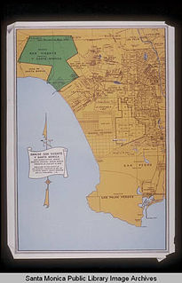
WRancho San Vicente y Santa Monica was a 33,000-acre (130 km2) Mexican land grant in present-day Los Angeles County, California given by governor Juan Alvarado in 1839 to Francisco Sepulveda, a soldier and citizen of Los Angeles. The rancho included what are now Santa Monica, Brentwood, Mandeville Canyon, and parts of West Los Angeles.
 W
WRancho Santa Ana del Chino was a 22,193-acre (89.81 km2) Mexican land grant in the Chino Hills and southwestern Pomona Valley, in present-day San Bernardino County, California.
 W
WRancho Santa Margarita y Las Flores was a 133,440-acre (540.0 km2) Mexican land grant in present-day northwestern San Diego County, California given by governor Juan Alvarado in 1841 to Andrés Pico and Pio Pico. The grant was located along the Pacific coast, and encompassed present-day San Onofre State Beach and Camp Pendleton. The site is now registered as California Historical Landmark #1026.
 W
WRancho Santa Rosa was a 47,815-acre (193.50 km2) Mexican land grant in present day Riverside County, California given in 1846 by Governor Pio Pico to Juan Moreno. At the time of the US patent, Rancho Santa Rosa was a part of San Diego County. Riverside County was created by the California Legislature in 1893 by taking land from both San Bernardino and San Diego Counties. The site is now registered as a California Historical Landmark.
 W
WRancho Simi, also known as Rancho San José de Nuestra Señora de Altagracia y Simí, was a 113,009-acre (457 km2) Spanish land grant in what is now eastern Ventura and western Los Angeles counties granted in 1795 to Santiago Pico. After Santiago Pico's death in 1815, the Rancho was regranted to Santiago's sons Javier Pico and his two brothers, Patricio Pico and Miguel Pico by Diego de Borica. The name derives from Shimiji, the name of a Chumash village in the Simi Valley for thousands of years before the Spanish arrival.
 W
WRancho Soquel was a 1,668-acre (6.75 km2) Mexican land grant in present-day Santa Cruz County, California given in 1833 by Governor José Figueroa to Martina Castro. In 1844, Martina Castro was granted by Governor José Figueroa a further 32,702-acre (132.34 km2) grant known as the Soquel Augmentation. The Rancho Soquel grant along Monterey Bay includes present-day Soquel and Capitola. Rancho Aptos of her brother Rafael Castro formed the south boundary of the grant. The much-larger Soquel Augmentation grant lay inland from both of these, and comprised mainly mountain watershed land.
 W
WRancho Temescal was a farming outpost of Mission San Luis Rey de Francia, one of the 21 Franciscan missions established in California by Spain during the late 18th and early 19th centuries. The Mission was located on the coast where Oceanside, California is today. The Rancho was settled in 1819 by Leandro Serrano, and became the first non-native settlement within the boundaries of what would become Riverside County, California.
 W
WRancho Thompson was a 35,533-acre (143.80 km2) Mexican land grant in present-day San Joaquin County and Stanislaus County, California given in 1846 by Governor Pío Pico to Alpheus Basil Thompson. The rectangular grant was 2 leagues along both sides of the Stanislaus River by 4 leagues – mostly north of the river. The grant encompassed present-day Riverbank and Oakdale.
 W
WRancho Tzabaco was a 15,439-acre (62.48 km2) Mexican land grant in present-day Sonoma County, California given in 1843 by Governor Manuel Micheltorena to José German Piña. The grant extended along Dry Creek, a tributary of the Russian River, north west of present-day Healdsburg and encompassed present-day Geyserville and the Dry Creek Valley AVA. The grant was immediately north of Henry D. Fitch's Rancho Sotoyome.
 W
WRancho Las Vírgenes was a 17,760-acre (71.9 km2) land grant in the Santa Monica Mountains and Simi Hills, in present day western Los Angeles County, California. The lands of the Rancho Las Vírgenes included present day Agoura Hills, Oak Park, and Westlake Village and part of the Santa Monica Mountains.