 W
WDiauehi or Daiaeni was a tribal union of possibly proto-Armenian, Hurrian or proto-Kartvelian groups, located in northeastern Anatolia, that was formed in the 12th century BC in the post-Hittite period. It is mentioned in the Urartian inscriptions. It is usually identified with the Yonjalu inscription of the Assyria king Tiglath-Pileser I's third year. Diauehi is a possible locus of Proto-Kartvelian; it has been described as an "important tribal formation of possible proto-Georgians" by Ronald Grigor Suny (1994). Although the exact geographic extent of Diauehi is still unclear, many scholars place it in the Pasinler Plain in today's northeastern Turkey, while others locate it in the Armenian–Georgian marchlands as it follows the Kura River. Most probably, the core of the Diauehi lands may have extended from the headwaters of the Euphrates into the river valleys of Çoruh to Oltu. The Urartian sources speak of Diauehi's three key cities – Zua, Utu and Sasilu; Zua is frequently identified with Zivin Kale and Ultu is probably modern Oltu, while Sasilu is sometimes linked to the early medieval Georgian toponym Sasire, near Tortomi. The region roughly corresponded to the previous Hayasa-Azzi territory.
 W
WDidnauri is a Late Bronze Age/Early Iron Age archaeological site in Georgia, located in the steppes of the Shiraki Plain in the country's southeasternmost municipality of Dedoplistsqaro. The National Agency for Cultural Heritage Preservation of Georgia, which supports the ongoing field works, has described it as "the largest ever ancient settlement" unearthed in the South Caucasus. The site is inscribed on the list of the Immovable Monuments of Cultural Heritage of Georgia.
 W
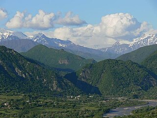
WGebi is an old village in the northern part of Georgian republic, in the region of Racha. From the northern slopes of Caucasus Gebi is bordered by Russia. Gebi with other two villages creates one ethno-cultural area, called Mtaracha. Gebi covers a territory of 355 km².
WGrakliani Hill is an archaeological excavation site in eastern Georgia near Kaspi, showing evidence of human presence possibly going back 300,000 years.
 W
WMartkopi is a village in Gardabani Municipality of Georgia. It is located on the left side of Ialno range, in the gorges of the rivers Alikhevi and Tevali, and is at an altitude of 770 meters. It is 55 kilometres from Gardabani and 12 kilometres from Vaziani. According to 2014 census, the village is populated by 7397 residents.
 W
WOni is a town in Racha-Lechkhumi and Kvemo Svaneti region (mkhare), Georgia. Historically and ethnographically, it is part of Racha, a historic highland province in western Georgia. The town also serves as an administrative center of the Oni district (raioni).
 W
WPichvnari is the site of a Colchian settlement; its ancient name is unknown. It is within modern Georgia, on the coast at the confluence of the Choloki and Ochkhamuri rivers, about 10 kilometres north of the seaside resort of Kobuleti.
 W
WTelavi is the main city and administrative center of Georgia's eastern province of Kakheti. Its population consists of some 19,629 inhabitants. The city is located on the foothills of the Tsiv-Gombori Range at 500–800 m (1,600–2,600 ft) above sea level.
 W
WTsnori is a town in Georgia’s Kakheti region. It is located in the Alazani Valley near the town Sighnaghi and has a population of 4,815.