 W
WThe Sierra Madre del Sur is a mountain range in southern Mexico, extending 1,000 kilometres (620 mi) from southern Michoacán east through Guerrero, to the Isthmus of Tehuantepec in eastern Oaxaca.
 W
WThe Sierra Madre del Sur pine–oak forests is a subtropical coniferous forest ecoregion of the Sierra Madre del Sur mountain range of southern Mexico.
 W
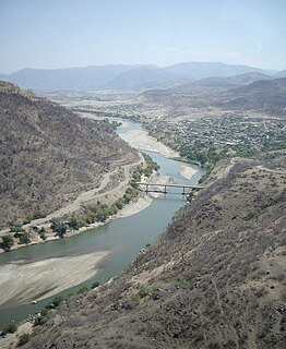
WThe Balsas River is a major river of south-central Mexico.
 W
WCerro Teotepec is a mountain summit located in the Mexican state of Guerrero. It is 3,550 meters high and is located in the Sierra Madre del Sur. It is located in the municipalities of Atoyac de Álvarez and General Heliodoro Castillo.
 W
WChilpancingo de los Bravo is the capital and second-largest city of the state of Guerrero, Mexico. In 2010 it had a population of 187,251 people. The municipality has an area of 2,338.4 km2 (902.9 sq mi) in the south-central part of the state, situated in the Sierra Madre del Sur, on the bank of the Huacapa River. The city is on Mexican Federal Highway 95 which connects Acapulco to Mexico City. It is served by Chilpancingo National Airport, which is one of the five airports in the state.
 W
WChilpancingo de los Bravo is one of the 81 municipalities of Guerrero, in south-western Mexico.
 W
WThe Isthmus of Tehuantepec is an isthmus in Mexico. It represents the shortest distance between the Gulf of Mexico and the Pacific Ocean. Prior to the opening of the Panama Canal, it was a major shipping route known simply as the Tehuantepec Route. The name is taken from the town of Santo Domingo Tehuantepec in the state of Oaxaca; this was derived from the Nahuatl term tecuani-tepec.
 W
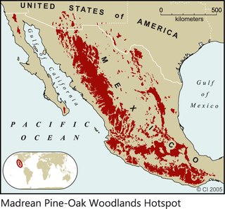
WThe Madrean pine–oak woodlands are an ecoregion of the Tropical and subtropical coniferous forests biome, located in North America. They are subtropical woodlands found in the mountains of Mexico and the southwestern United States.
 W
WZumpango del Río is the capital of Eduardo Neri Municipality, within the state of Guerrero, in central−western Mexico.