 W
WHighway 5 or the Trans-Samaria Highway, is one of Israel's main highways, connecting the Mediterranean coast immediately north of Tel Aviv with the central Sharon plain and eastwards to Ariel and other Israeli settlements in the northern West Bank.
 W
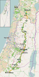
WHighway 60 or is a south-north intercity road in Israel and the West Bank that stretches from Beersheba to Nazareth.
 W
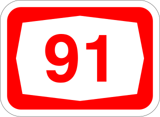
WHighway 91 is an east-west highway in northern Israel and the Golan Heights. It extends through the Jordan Rift Valley and the central Golan Heights. It begins in the west at Mahanayim junction with Highway 90, and it ends in the east at Zivan junction near the Israeli settlement Ein Zivan, where it meets Highway 98. The road is 28 km long.
 W
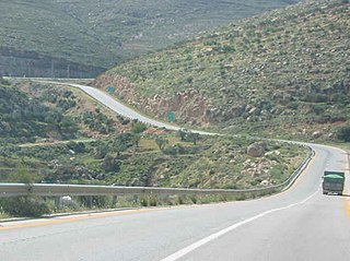
WHighway 98 is the primary north-south highway in the Golan Heights. It is shaped like an archer's bow, and it runs parallel to the ceasefire line of the occupied territory with the rest of Syria. The route runs from Tzemah junction south of the Kinneret, first through the Yarmuk valley, then it rises up a steep slope into the Golan Heights and crosses it until it reaches the lowest cable-car station on Mount Hermon. There it meets Route 999. Highway 98 is steep compared to the highways in Israel, rising from 210 meters below sea level at the Kinneret to 1600 meters above sea level on the Hermon.
 W
WHighway 99 is an east-west highway in the Finger of the Galilee in far northeast of Israel and the Golan Heights. It begins in the west at HaMetzodot junction in Kiryat Shmona, and it ends in the east at the Druze city of Mas'ade. After it reaches the Banias tributary, the road follows the path of Sa'ar River. Highway 99 is 24 km long.
 W
WRoute 417 is an intercity road in Israel and the West Bank that stretches from the west side of Jerusalem to Ma'ale Adumim and Highway 1 east to the Jordan Valley.
 W
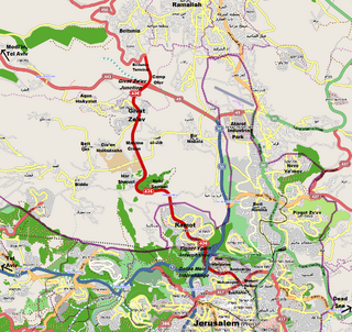
WRoute 436 is a regional arterial road in Israel and the West Bank between Jerusalem and Givat Ze'ev. The southern portion begins as a major urban artery in Jerusalem's predominantly Hareidi neighborhoods leading to Highway 50, to Highway 1 and to the northern neighborhood of Ramot. Further north, the road runs alongside portions of Israel's West Bank Barrier as it approaches Givat Ze'ev. It crosses Route 443 to the Tel Aviv area and Highway 45 to Atarot and ends at the Beitunia section of the security barrier. The speed limit begins at 50 km/h along its urban section becoming 70 km/h as it passes through Ramot and then becoming 90 km/h as it leaves the Jerusalem municipality northwards. The road officially ends at the Beitunya cargo transfer terminal.
 W
WRoute 443 is also known as Ma'ale Beit Horon, following the ancient east-west trade route connecting the Via Maris and the Way of the Patriarchs. It is the main highway connecting Tel Aviv and Gush Dan with Jerusalem via Modi'in. While technically listed as a regional road, it is for the most part a divided, four-lane highway which utilises some grade separation and interchanges, as well as major at-grade intersections, and thus is not classified as a motorway, even though there is a short motorway section on its western end, connecting it to westbound Highway 1.
 W
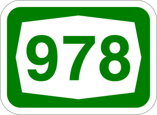
WRoute 978 is a regional north-south Israeli highway in the Golan Heights.
 W
WRoute 999 is an east–west regional route in the northern Golan Heights, which Israel captured from Syria in the Six-Day War in 1967. For almost its entire length its access is restricted to Israeli army vehicles. It begins from Sion adjacent to the community Snir and the village Ghajar, where it splits north from Highway 99. About 2 km after this junction stands an IDF checkpoint. After the checkpoint the road moves in a northeast direction and climbs steeply on Shebaa farms in parallel with the international border between Golan Heights and Lebanon. The road passes near the Shebaa farms while it passes on its steep course in the Mount Hermon nature reserve. For the entire length of the road, IDF installations are standing, and it ends its length of 29 km with another IDF checkpoint near the lower cable-car of Mount Hermon, where it meets Highway 98.
 W
WAllon Road is the name given by Israel to Routes 458, 508, and 578 in the West Bank, running roughly south-north along the eastern watershed of the Samarian and Judaean Mountains between Highway 1 near Kfar Adumim east of Jerusalem and Highway 90 at Mehola in the central Jordan Valley.
 W
WThe Petroleum Road or Tapline Road is a privately owned north–south asphalt road in the Golan Heights. It is 47 km (29 mi) long. It begins near Mount Peres on the east edge of the central Golan, and ends in the northern Golan near the Israeli-occupied Golan-Lebanese frontier, nearby Ghajar.
 W
WRoute 959 is a regional east-west highway in the Golan Heights. It proceeds from Gonen junction in the west until Baron Junction in the east.