 W
WRoyal Air Force Chelveston or more simply RAF Chelveston is a former Royal Air Force station located on the south side of the B645, 5 miles (8.0 km) east of Wellingborough, near the village of Chelveston in Northamptonshire, England. During the Second World War the airfield was occupied by both the Royal Air Force and the United States Army Air Forces. It was given the USAAF designation Station 105.
 W
WRAF Collyweston is a former Royal Air Force satellite station located 3.2 miles (5.1 km) south west of Stamford, Lincolnshire and 11 miles (18 km) north east of Corby, Northamptonshire, England.
 W
WRoyal Air Force Croughton or more simply RAF Croughton is a Royal Air Force station which is currently a United States Air Force communications station in Northamptonshire, England. It is southeast of the village of Croughton. The station is home to the 422nd Air Base Group and operates one of Europe's largest military switchboards and processes approximately a third of all U.S. military communications in Europe.
 W
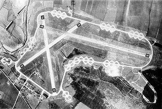
WRoyal Air Force Deenethorpe or more simply RAF Deenethorpe is a former Royal Air Force station located 2 miles (3.2 km) east of Corby, Northamptonshire, England.
 W
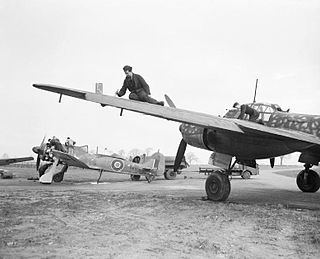
WRoyal Air Force Grafton Underwood or more simply RAF Grafton Underwood is a former Royal Air Force station located 4 miles (6.4 km) northeast of Kettering, Northamptonshire, England.
 W
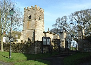
WGreatworth is a village in the civil parish of Greatworth and Halse about 4 miles (6.4 km) north-west of Brackley, South Northamptonshire, England. The parish also includes the hamlet of Halse. In 2011 the settlement had a population of 708. The 2011 Census recorded the parish population as 890.
 W
WRoyal Air Force Station Harrington or more simply RAF Harrington is a former Royal Air Force station in England about 5.6 miles (9.0 km) west of Kettering in Northamptonshire south of the village of Harrington off the A14 road. During the early Cold War, it was a Thor missile site, designed to deliver atomic warheads to the Soviet Union. The nuclear missile site is now protected as a Grade II listed building as an example of Cold War architecture.
 W
WRoyal Air Force Kings Cliffe or more simply RAF Kings Cliffe is a former Royal Air Force station located near Kings Cliffe, Northamptonshire, 12 miles (19 km) west of Peterborough in Cambridgeshire. The airfield was built with hard-surfaced runways and a perimeter track, these were extended early in 1943.
 W
WRAF Lilbourne is a former Royal Air Force station which was located 5.2 miles (8.4 km) south of Lutterworth, Leicestershire, England.
 W
WRoyal Air Force Peterborough or more simply RAF Peterborough is a former Royal Air Force installation in Cambridgeshire located 2 miles (3.2 km) northwest of Peterborough city centre and 9.4 miles (15.1 km) southeast of Stamford, Lincolnshire, England.
 W
WRoyal Air Force Station Polebrook or more simply RAF Polebrook is a former Royal Air Force station located 3.5 miles (5.6 km) east-south-east of Oundle, at Polebrook, Northamptonshire, England. The airfield was built on Rothschild estate land starting in August 1940.
 W
WRoyal Air Force Desborough or more simply RAF Desborough is a former Royal Air Force airfield located in Northamptonshire, England
 W
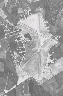
WRoyal Air Force Station Silverstone or more simply RAF Silverstone is a former Royal Air Force (RAF) station, the site is now used as Silverstone Circuit. It straddles the Northamptonshire and Buckinghamshire border and is named after the nearby village of Silverstone. It is 10 miles (16 km) south west of Northampton, 11.1 miles (17.9 km) west of Milton Keynes, Buckinghamshire and 13.9 miles (22.4 km) east of Banbury, Oxfordshire, England and was opened in 1943 during the Second World War.
 W
WRoyal Air Force Spanhoe or more simply RAF Spanhoe is a former Royal Air Force station in Northamptonshire, England. The airfield is located approximately 4 miles (6.4 km) east of Uppingham; about 80 miles (130 km) north-northwest of London
 W
WSywell Aerodrome is the local aerodrome serving the town of Northampton, Wellingborough, Kettering and Rushden, as well as wider Northamptonshire. The aerodrome is located 5 nautical miles northeast of Northampton and was originally opened in 1928 on the edge of Sywell village.