 W
WAjo Air Force Station is a closed United States Air Force General Surveillance Radar station. It is located 6.4 miles (10.3 km) northwest of Ajo, Arizona. It was closed in 1969 by the Air Force, and the radar site turned over to the Federal Aviation Administration (FAA).
 W
WBaudette Air Force Station is a closed United States Air Force General Surveillance Radar station. It is located 3.1 miles (5.0 km) south-southwest of Baudette, Minnesota. It was closed in 1979.
 W
WBethel Air Force Station is a closed United States Air Force General Surveillance Radar station. It was located 402 miles (647 km) west of Anchorage, Alaska.
 W
WCanadian Forces Station Lowther is a closed General Surveillance Radar station. It is located 12.7 miles (20.4 km) east-southeast of Mattice-Val Côté, Ontario. It was closed in 1987.
 W
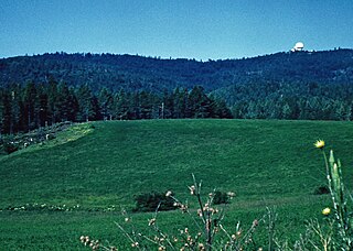
WCottonwood Air Force Station is a former United States Air Force General Surveillance Radar station. The radar site was located at the summit of Cottonwood Butte, 5.7 miles (9.2 km) west-northwest of Cottonwood in Idaho County, Idaho. It was closed in 1965 and transferred to the state of Idaho in 1974, when it was converted to its present use as a minimum-security correctional facility.
 W
WCrystal Springs Air Force Station is a closed United States Air Force General Surveillance Radar station. It is located in Crystal Springs, Mississippi. It was closed in 1968.
 W
WFort Yukon Long Range Radar Site is a radar site of the United States Air Force. It is located 1.6 miles (2.6 km) east-southeast of Fort Yukon, Alaska.
 W
WKotzebue Air Force Station is a closed United States Air Force General Surveillance Radar station. It is located 4 miles (6.4 km) south of Kotzebue, Alaska.
 W
WLewistown Air Force Station is a closed United States Air Force General Surveillance Radar station. It is located 7.0 miles (11.3 km) east-southeast of Hilger, Montana. It was closed in 1971.
 W
WMiddleton Island Air Force Station is a closed United States Air Force General Surveillance Radar station. It was located on Middleton Island, in the Gulf of Alaska, 173 miles (278 km) south of Anchorage, Alaska.
 W
WNaval Air Station Joint Reserve Base New Orleans is a base of the United States military located in Belle Chasse, unincorporated Plaquemines Parish, Louisiana, United States. NAS JRB New Orleans is home to a Navy Reserve strike fighter squadron and a fleet logistics support squadron, the 159th Fighter Wing of the Louisiana Air National Guard, Coast Guard Air Station New Orleans, a detachment of a Marine Corps Reserve light helicopter attack squadron, as well as other US Navy & US Army activities. The base has a 24/7 operating schedule to support both the 159 FW's NORAD air sovereignty/homeland defense requirements and for Coast Guard Air Station New Orleans search and rescue/maritime law enforcement/port security missions. It contains a military airport known as Alvin Callender Field which is located three nautical miles (6 km) south of the central business district of New Orleans. The base's predecessor, NAS New Orleans, occupied the current location of the University of New Orleans's principal campus until 1957.
 W
WOhlson Mountain Air Force Station is a closed United States Air Force General Surveillance Radar station. It was located 118 miles (190 km) south-southwest of Anchorage, Alaska.
 W
WPort Isabel Air Force Station is a closed United States Air Force General Surveillance Radar station. It is located 18.7 miles (30.1 km) north-northeast of Brownsville, Texas. It was closed in 1961.
 W
WTexas Tower 2 was a former United States Air Force Texas Tower General Surveillance Radar station, first operational in 1955. It was located 110 miles (180 km) east of Cape Cod, Massachusetts, in 56 feet (17 m). The tower was closed in 1963 and dismantled.
 W
WTexas Tower 3 was a former United States Air Force Texas Tower General Surveillance Radar station, first operational in November 1956. 50 miles (80 km) southeast of the coast of Nantucket, Massachusetts, in 80 feet of water. The tower was closed in 1963 and dismantled.
 W
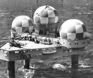
WTexas Tower 4 was a United States Air Force Texas Tower General Surveillance Radar station, located 63 miles (101 km) south-southwest off the coast of Long Island, New York in 185 feet (56 m) of water. The tower was the site of an accident and was destroyed by a winter storm on January 15, 1961. None of the twenty-eight airmen and civilian contractors who were manning the station survived.
WUnalakleet Air Force Station is a closed United States Air Force General Surveillance Radar station. It was located 394 miles (634 km) west of Fairbanks, Alaska.