 W
WFort Ballance is a former coastal artillery battery on Point Gordon on Wellington's Miramar Peninsula.
 W
WThe Battle of Ohaeawai was fought between British forces and local Māori during the Flagstaff War in July 1845 at Ohaeawai in the North Island of New Zealand. Te Ruki Kawiti, a prominent rangatira (chief) was the leader of the Māori forces. The battle was notable in that it established that the fortified pā could withstand bombardment from cannon fire and that frontal assaults by soldiers would result in serious troop losses.
 W
WThe remains of Fort Buckley, in Wellington, New Zealand, overlook the Interislander ferry terminal, the Wellington Harbour & the Wellington Motorway towards the Hutt Valley.
 W
WThe Cameron Blockhouse is a timber blockhouse in Wanganui, New Zealand, built during the New Zealand Wars in the mid-1800s. It is a rare surviving example of a privately constructed redoubt from that era.
 W
WCoastal fortifications were constructed in New Zealand in two main waves: around 1885 as a response to fears of an attack by Russia, and in World War II due to fears of invasion by the Japanese.
 W
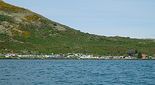
WThe settlement of Harington Point lies within the boundaries of the city of Dunedin, New Zealand. It is located at the Otago Heads, at the northeastern end of Otago Peninsula, close to the entrance of Otago Harbour. The mouth of the harbour is at its narrowest at Harington Point, only some 400 metres separating the point from the mudflats at Aramoana on the opposing coast.
 W
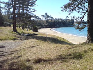
WHuriawa, commonly known as Huriawa Peninsula or Karitane Peninsula, is a headland on the coast of Otago, New Zealand. It is located 35 kilometres north of Dunedin city centre, immediately to the southeast of the settlement of Karitane.
 W
WMotuihe Island lies between Motutapu and Waiheke islands in the Hauraki Gulf of New Zealand, near Auckland. The island measures 179 ha, of which around 18 ha are remnants of coastal forest. The island is a recreation reserve controlled by the Department of Conservation (DOC) and administered by the Motuihe Trust. It is a popular spot for day trips, accessible by 30-minute ferry trip from Auckland, by seaplane, or by private boat. The island is known for its beautiful beaches.
 W
WMount Taupiri is a hill at the southern end of the Taupiri Range in the Waikato. The highest peak in the range, it rises to 288 metres above sea level and overlooks Taupiri township immediately to its south. It is separated from the Hākarimata Range to the south by the Taupiri Gorge, through which the Waikato River flows from the Waikato Basin to the Lower Waikato. The Mangawara Stream joins the Waikato River at the base of the hill.
 W
WTakarunga / Mount Victoria is the highest volcano on Auckland's North Shore, rising to 87 m. Its age is currently unknown. Its lava flows now line much of Devonport's waterfront. An important pa (fortification) once occupied its slopes, and some of the pa's earthworks can still be seen. A scoria mound known as Duders Hill, on Takarunga / Mount Victoria's southern slopes was mostly quarried away. The name Mount Victoria comes from Queen Victoria and the name Takarunga means "the hill standing above". Jules Dumont d'Urville climbed the hill in 1827.
 W
WMaungauika is a volcano forming a headland called North Head at the east end of the Waitematā Harbour in Auckland, New Zealand, in the suburb of Devonport. Known for its sweeping views over the harbour and the Hauraki Gulf, since 1885 the head was mainly used by the military as a coastal defence installation, which left a network of accessible old bunkers and tunnels as its legacy, forming part of the attraction. The site was protected as part of Hauraki Gulf Maritime Park in 1972 and listed as a Category I historic place in 2001. As part of a 2014 Treaty of Waitangi claim settlement the volcanic cone was officially named Maungauika and the reserve renamed Maungauika / North Head Historic Reserve. Maungauika is the Māori word for Mountain of Uika.
 W
WRipapa Island is located just off the shore of Lyttelton Harbour (Whakaraupo) has played many roles in the history of New Zealand. The island initially played a key role in an internal struggle for the South Island Ngāi Tahu tribe in the early 19th Century. Between 1873 and 1885 the island was used as a quarantine station for ships arriving from Britain to the nearby port in Lyttelton, though 1880 saw the use of the quarantine buildings as a prison, notably for members of the Parihaka Māori settlement in Taranaki during its passive resistance campaign against the surveying and selling of its land by the government. The quarantine buildings were dismantled when the Island was incorporated into the coastal defence scheme.
 W
WRuapekapeka is a pā 20 kilometres (12 mi) southeast of Kawakawa in the Northland Region of New Zealand. It is one of the largest and most complex pā in New Zealand, that was designed specifically to counter the cannons of the British forces. The earthworks can still be seen.
 W
WStony Batter is a historic defence installation at the northeastern end of Waiheke Island, Auckland, New Zealand. It is sited within a 50-acre scenic reserve of the same name, owned by the New Zealand Department of Conservation (DOC). The park serves double duty as a historical and nature reserve, containing unusual rock formations, three significant bush blocks and three concrete gun emplacements with an extensive tunnel system, reputed to be the largest in New Zealand.
 W
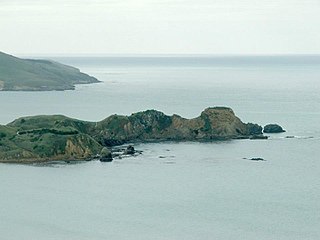
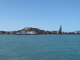
WTaiaroa Head is a headland at the end of the Otago Peninsula in New Zealand, overlooking the mouth of the Otago Harbour. It lies within the city limits of Dunedin. The nearest settlement, Otakou, lies three kilometres to the south.
 W
WTe Ahuahu is a 373 m high basaltic scoria cone, in the Kaikohe-Bay of Islands volcanic field in New Zealand.
 W
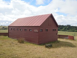
WThe Upper Hutt Blockhouse also known as the Wallaceville Blockhouse is a 19th-century American-style military blockhouse situated in Upper Hutt, New Zealand. One of very few such blockhouses built in New Zealand, it is preserved as a Category I historic place. It was built in late 1860 as part of a larger Stockade and was one of two Blockhouses and Stockades built in the Hutt Valley that year. It was occupied by the Hutt Battalion of the Wellington Militia from December 1860 to May 1861 without coming under hostile attack.
 W
WWrights Hill Fortress is a counter bombardment coastal artillery battery in the Karori suburb of Wellington, New Zealand. It was built between 1942 and 1947 and is predominantly underground, with numerous tunnels linking the war shelters, gun emplacements, magazines, plotting rooms and engine room - which are, at some points, over 50 feet underground. The fort was intended to house three 9.2" Mk. XV guns, but only two guns were installed and the fort never saw action. After World War II was over, fort commanders fired both of the guns. The fall of the shot was observed in Cook Strait and these test firings were deemed a success. In 1960, somewhat ironically, both of the guns were sold to the Japanese as scrap metal, the very nation Wrights Hill Fortress was constructed to defend Wellington against. The design of the fort is similar to the Stony Batter and Whangaparaoa 9.2" Mk. XV batteries, near Auckland.