 W
WIn October 1857, an expedition led by Edward Fitzgerald Beale was tasked with establishing a trade route along the 35th parallel from Fort Smith, Arkansas to Los Angeles, California.
 W
WBetween 1913 and 1938, Joseph Hampton Rich, a resident of Mocksville, North Carolina, took it upon himself to keep the memory of Daniel Boone and his travels alive. He did this by placing 358 metal tablets between Virginia Beach, Virginia and San Francisco, California. Although many of the tablets are associated with locations visited by Boone, many were simply placed wherever Mr. Rich could collect the necessary donations from schools, communities, etc. to erect a monument. He established the Boone Trail Highway Association to further his project. From the mid-1920s to the mid-1930s, the Association published a newsletter which detailed the efforts to install new monuments.
 W
WThe Boston Post Road was a system of mail-delivery routes between New York City and Boston, Massachusetts, that evolved into one of the first major highways in the United States.
 W
WThe Vincennes Trace was a major trackway running through what are now the American states of Kentucky, Indiana, and Illinois. Originally formed by millions of migrating bison, the Trace crossed the Ohio River near the Falls of the Ohio and continued northwest to the Wabash River, near present-day Vincennes, before it crossed to what became known as Illinois. This buffalo migration route, often 12 to 20 feet wide in places, was well known and used by American Indians. Later European traders and American settlers learned of it, and many used it as an early land route to travel west into Indiana and Illinois. It is considered the most important of the traces to the Illinois country.
 W
WThe California Trail was an emigrant trail of about 3,000 mi (4,800 km) across the western half of the North American continent from Missouri River towns to what is now the state of California. After it was established, the first half of the California Trail followed the same corridor of networked river valley trails as the Oregon Trail and the Mormon Trail, namely the valleys of the Platte, North Platte, and Sweetwater rivers to Wyoming. In the present states of Wyoming, Idaho, and Utah, the California and Oregon trails split into several different trails or cutoffs.
 W
WThe Cherokee Path was the primary route from Charleston to Columbia, South Carolina in Colonial America, connecting all of the Cherokee territories.
 W
WThe National Road was the first major improved highway in the United States built by the federal government. Built between 1811 and 1837, the 620-mile (1,000 km) road connected the Potomac and Ohio Rivers and was a main transport path to the West for thousands of settlers. When improved in the 1830s, it became the second U.S. road surfaced with the macadam process pioneered by Scotsman John Loudon McAdam.
WThe National Road was the first major improved highway in the United States built by the federal government. Built between 1811 and 1837, the 620-mile (1,000 km) road connected the Potomac and Ohio Rivers and was a main transport path to the West for thousands of settlers. When improved in the 1830s, it became the second U.S. road surfaced with the macadam process pioneered by Scotsman John Loudon McAdam.
 W
WEl Camino Real is the name that the Spanish gave to a trail they cleared in the 1680s, mostly over the traditional trails of Native Americans, from St. Augustine westward to the Spanish missions in north Florida. Before this time, transpeninsular traffic in La Florida between the western mission settlements and the capital depended on water routes from Apalachee to St. Augustine. Agricultural commodities produced in Apalachee were carried by canoes to the Gulf of Mexico and southward on the coast to the mouth of the Suwanee River, then upriver to a location on the Santa Fe River. There they were loaded onto pack animals or the backs of Indian burderners (porters) for the remainder of the overland trip. Provisions and funds from the real situado were sent on the same route in reverse.
 W
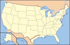
WThe El Camino Real de los Tejas National Historic Trail is a national historic trail covering the U.S. section of El Camino Real de Los Tejas, a thoroughfare from the 18th-century Spanish colonial era in Spanish Texas, instrumental in the settlement, development, and history of Texas. The National Park Service designated El Camino Real de los Tejas National Historic Trail as a unit in the National Trails System in 2004.
 W
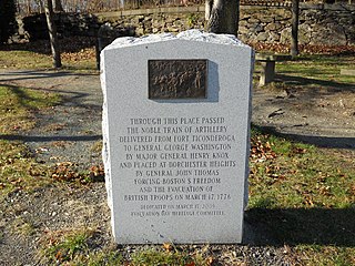
WThe Henry Knox Trail, also known as the Knox Cannon Trail, is a network of roads and paths that traces the route of Colonel Henry Knox's "noble train of artillery" from Crown Point to the Continental Army camp outside Boston, Massachusetts early in the American Revolutionary War.
WThe National Road was the first major improved highway in the United States built by the federal government. Built between 1811 and 1837, the 620-mile (1,000 km) road connected the Potomac and Ohio Rivers and was a main transport path to the West for thousands of settlers. When improved in the 1830s, it became the second U.S. road surfaced with the macadam process pioneered by Scotsman John Loudon McAdam.
WThe National Road was the first major improved highway in the United States built by the federal government. Built between 1811 and 1837, the 620-mile (1,000 km) road connected the Potomac and Ohio Rivers and was a main transport path to the West for thousands of settlers. When improved in the 1830s, it became the second U.S. road surfaced with the macadam process pioneered by Scotsman John Loudon McAdam.
WThe National Road was the first major improved highway in the United States built by the federal government. Built between 1811 and 1837, the 620-mile (1,000 km) road connected the Potomac and Ohio Rivers and was a main transport path to the West for thousands of settlers. When improved in the 1830s, it became the second U.S. road surfaced with the macadam process pioneered by Scotsman John Loudon McAdam.
 W
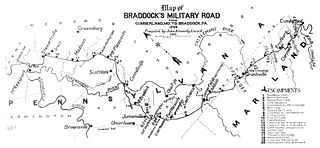
WNemacolin's Trail, or less often Nemacolin's Path, was an ancient Native American trail that crossed the great barrier of the Allegheny Mountains via the Cumberland Narrows Mountain pass, connecting the watersheds of the Potomac River and the Monongahela River in the present-day United States of America. Nemacolin's Trail connected what are now Cumberland, Maryland and Brownsville, Pennsylvania.
 W
WThe Santa Fe, Prescott and Phoenix Railway (SFP&P) was a common carrier railroad that later became an operating subsidiary of the Atchison, Topeka and Santa Fe Railway in Arizona. At Ash Fork, Arizona, the SFP&P connected with Santa Fe's operating subsidiary, the Atlantic & Pacific Railroad mainline, that ran from California to Chicago. The SFP&P's 195-mile (314 km) line extended the Santa Fe Railway south into Phoenix. The SFP&P extended another 100 miles (160 km) to the east from Phoenix to Florence and Winkelman via the Phoenix and Eastern Railroad. The SFP&P also served several mines in the Prescott area through its various subsidiary railroads.
 W
WThe Sauk Trail was originally a Native American trail running through what are present-day Illinois, Indiana and Michigan in the United States. From west to east, the trail ran from Rock Island on the Mississippi River to the Illinois River near modern Peru then along the north bank of that river to Joliet, and on to Valparaiso, Indiana. Then it ran northeasterly to La Porte and into southern Michigan running through Niles, Sturgis, Ypsilanti, and ending at the Detroit River near Detroit.
 W
WThe Southwest Trail was a 19th-century pioneer route that was the primary passageway for American settlers bound for Texas.
 W
WThe Wilderness Road was one of two principal routes used by colonial and early national era settlers to reach Kentucky from the East. Although this road goes through the Cumberland Gap into southern Kentucky and northern Tennessee, the other is sometimes called the "Cumberland Road" because it started in Fort Cumberland in Maryland. Despite Kentucky Senator Henry Clay's advocacy of this route, early in the 19th century, the northern route was selected for the National Road, connecting near Washington, Pennsylvania into the Ohio Valley of northern Kentucky and Ohio.