 W
WThe Arbitration Rock was set in 1769 as the boundary marker between the two Long Island townships of Newtown and Bushwick. Since Newtown was in Queens County and Bushwick in Kings County, this rock the size of a Volkswagen Beetle also served to mark the dividing line between these two colonial New York counties.
 W
WThe Black Hills land claim is an ongoing land dispute between Native Americans from the Sioux Nation and the United States government. The land in question was pledged to the Sioux Nation in the Fort Laramie Treaty of April 29, 1868, but effectively nullified without the Nation's consent in the Indian Appropriations Bill of 1876. That bill “denied the Sioux all further appropriation and treaty-guaranteed annuities” until they gave up the Black Hills. A Supreme Court case was ruled in favor of the Sioux in 1980. The Sioux have outstanding issues with the ruling and have not collected the funds. As of 2011, the award was worth over $1 billion.
 W
WDuring the American colonial era, the colonies of New York and Connecticut often disputed the precise location of their shared border, leading to a border dispute that eventually gave the colonies their modern shapes. Though the dispute was officially resolved in 1731, effects of the boundary conflict persisted until well after both colonies gained statehood as part of the United States following the American Revolution.
 W
WCarter Lake is a city in Pottawattamie County, Iowa, United States, and a suburb of Omaha, Nebraska, and sits surrounding the south and west sides of the region's major airport, Eppley Airfield. The population was 3,785 at the 2010 census.
 W
WEllis Island is a federally owned island in New York Harbor that was the United States' busiest immigrant inspection station. From 1892 to 1924, approximately 12 million immigrants arriving at the Port of New York and New Jersey were processed there under federal law. Today, it is part of the Statue of Liberty National Monument, accessible to the public only by ferry. The north side of the island is the site of the main building, now a national museum of immigration. The south side of the island, including the Ellis Island Immigrant Hospital, is only open to the public through guided tours.
 W
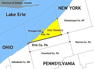
WThe Erie Triangle is a roughly 300-square-mile tract of American land that was the subject of several competing colonial-era claims and which was eventually acquired by the U.S. federal government and sold to Pennsylvania so that the state would have access to a freshwater port on Lake Erie. The Erie Triangle land makes up a large portion of present-day Erie County, Pennsylvania.
 W
WThe Honey War was a bloodless territorial dispute in 1839 between Iowa Territory and Missouri over their border.
 W
WLiberty Island is a federally owned island in Upper New York Bay in the United States. Its most notable feature is the Statue of Liberty, a large statue by Frédéric Auguste Bartholdi that was dedicated in 1886. Long known as Bedloe's Island, it was renamed by an act of the United States Congress in 1956. Part of New York State, the island is an exclave of the New York City borough of Manhattan, surrounded by the waters of Jersey City, New Jersey.
 W
WMechanicsville is an unincorporated community in New Castle County, Delaware.
 W
WNew York v. Connecticut, 4 U.S. 1 (1799), was a lawsuit heard by the Supreme Court of the United States between the State of New York against the State of Connecticut in 1799 that arose from a land dispute between private parties. The case was the first case in which the Supreme Court exercised its original jurisdiction under Article III of the United States Constitution to hear controversies between two states.
 W
WThe New York – New Jersey Line War was a series of skirmishes and raids that took place for over half a century between 1701 and 1765 at the disputed border between two American colonies, the Province of New York and the Province of New Jersey.
 W
WThe Pennamite–Yankee Wars or Yankee–Pennamite Wars were a series of conflicts consisting of the First Pennamite War (1769–1770), the Second Pennamite War (1774), and the Third Pennamite War (1784), in which the Wyoming Valley along the North Branch of the Susquehanna River was disputed between settlers from Connecticut (Yankees) and Pennsylvania (Pennamites).
 W
WThe Piscataqua River border dispute was a dispute between the US states of Maine and New Hampshire over ownership of Seavey’s Island in the Piscataqua River, which forms the border between Maine and New Hampshire. The dispute was settled in 2002 by the US Supreme Court in favor of Maine.
 W
WThe Tennessee River is the largest tributary of the Ohio River. It is approximately 652 miles (1,049 km) long and is located in the southeastern United States in the Tennessee Valley. The river was once popularly known as the Cherokee River, among other names, as many of the Cherokee had their territory along its banks, especially in eastern Tennessee and northern Alabama. Its current name is derived from the Cherokee village Tanasi.
 W
WThe Tennessee-Georgia water dispute is an ongoing territorial dispute between the U.S. States of Tennessee and Georgia about whether or not the border between the two states should have been located further north, allowing a small portion of the Tennessee River to be located in Georgia. The dispute has existed since the 19th century, but was further fueled by the increase in demand for water due to the rapid growth of the Atlanta metropolitan area which began in the latter 20th century.
 W
WTurtle Island is a 1.5-acre (0.61 ha) island in the western portion of Lake Erie in the United States. The island has an unusual political status, as its jurisdiction is divided between the U.S. states of Michigan and Ohio, even though the island has no residents or current use. Turtle Island is located about five miles (8.0 km) northeast of the mouth of the Maumee River in Maumee Bay. Today, the island houses several abandoned structures and the ruins of Turtle Island Light, a lighthouse dating back to 1866. According to the Census Bureau, most of the island lies in Jerusalem Township in Lucas County, Ohio with the smaller Michigan portion being part of Erie Township.
 W
WThe Twelve-Mile Circle is an approximately circular arc which forms most of the boundary between the Commonwealth of Pennsylvania and the State of Delaware in the United States. It is not actually a circle, but rather a combination of different circular arcs that have been feathered together.
 W
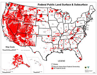
WThe State of Utah passed legislation in 2012—the Utah Transfer of Public Lands Act—to require the Federal government to grant the majority of federal land in the state to the state of Utah after 2014. According to Donald J. Kochan, the federal government promised to transfer these lands to the State in the Utah Enabling Act of 1894.
 W
WThe Wedge is a 1.068-square-mile tract of land along the borders of Delaware, Maryland and Pennsylvania. Ownership of the land was disputed until 1921; it is now recognized as part of Delaware. The tract was created primarily by the shortcomings of contemporary surveying techniques when the boundaries were defined in the 18th century. It is bounded on the north by an eastern extension of the east–west portion of the Mason–Dixon line, on the west by the north–south portion of the Mason–Dixon line, and on the southeast by the Twelve-Mile Circle around New Castle, Delaware. The crossroads community of Mechanicsville, Delaware lies within the area today.
 W
WThe West Florida Controversy included two border disputes that involved Spain and the United States in relation to the region known as West Florida over a period of 37 years. The first dispute commenced immediately after Spain received the colonies of West and East Florida from the Kingdom of Great Britain following the American Revolutionary War. Initial disagreements were settled with Pinckney's Treaty of 1795.
 W
WTwo Supreme Court cases, Wisconsin v. Michigan, 295 U.S. 455 (1935) and Wisconsin v. Michigan, 297 U.S. 547 (1936), settled a territorial dispute between Wisconsin and Michigan.
 W
WYohogania County was created by the new state of Virginia in 1776, in an area long disputed between Virginia and Pennsylvania. The county ceased to exist after the border dispute between the two states was resolved in the 1780s. Thus, it is sometimes referred to as a "lost county," although 1.5 million people live within the territory it once claimed, which encompasses two entire counties and parts of four others in two states.