 W
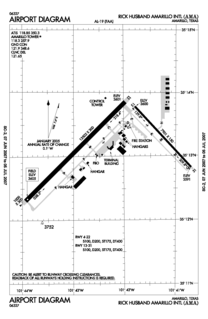
WRick Husband Amarillo International Airport is a public airport six miles (10 km) east of downtown Amarillo, in Potter and Randall Counties, Texas, United States. The airport was renamed in 2003 after NASA astronaut and Amarillo native Rick Husband, who died in the Space Shuttle Columbia disaster in February of that year.
 W
WBelleville Air Force Station is a closed United States Air Force General Surveillance Radar station. It is located 2 miles (3.2 km) southeast of Belleville, Illinois. It was closed in 1968.
 W
WCartwright Air Station is a closed General Surveillance Radar station. It is located 145.2 miles (233.7 km) east-northeast of CFB Goose Bay, Newfoundland and Labrador. It was closed in 1968.
 W
WCrystal Springs Air Force Station is a closed United States Air Force General Surveillance Radar station. It is located in Crystal Springs, Mississippi. It was closed in 1968.
 W
WBangor Air National Guard Base is a United States Air National Guard base. Created in 1927 as the commercial Godfrey Field, the airfield was taken over by the U.S. Army just before World War II and renamed Godfrey Army Airfield and later Dow Army Airfield. It became Dow Air Force Base in 1947, when the newly formed U.S. Air Force took over many Army air assets. In 1968, the base was sold to the city of Bangor, Maine, to become Bangor International Airport but has since continued to host Maine Air National Guard units under a lease agreement with the city.
 W
WEufaula Air Force Station is a closed United States Air Force General Surveillance Radar station. It is located 6.4 miles (10.3 km) west of Eufaula, Alabama. It was closed in 1968.
 W
WGettysburg Air Force Station is a closed United States Air Force General Surveillance Radar station. It is located 2.6 miles (4.2 km) north of Gettysburg, South Dakota. It was closed in 1968.
 W
WHanna City Air Force Station is a closed United States Air Force General Surveillance Radar station. It is located 1.6 miles (2.6 km) west-northwest of Hanna City, Illinois. It was closed in 1968. It is still in use by the Federal Aviation Administration as a Joint Surveillance System radar station.
 W
WHopedale Air Station is a General Surveillance Radar station that the USAF closed in 1968. It is located north of the community of Hopedale, Newfoundland and Labrador 147.8 miles (237.9 km) west-northwest of CFB Goose Bay, Newfoundland and Labrador, Canada.
 W
WHutchinson Air Force Station is a closed United States Air Force station. It is located 2 miles (3.2 km) west-southwest of Yoder, Kansas. It was closed for all military use in 1968. It was operated alongside Hutchinson Air National Guard Base when it was operational.
 W
WJames Connally Air Force Base was a United States Air Force base located north of Waco, Texas. After its closure in 1968, the airport reopened as TSTC Waco Airport.
 W
WKirksville Air Force Station is a closed United States Air Force General Surveillance Radar station. It is located 7.1 miles (11.4 km) north of Kirksville, Missouri. It was closed by the Air Force in 1968. Today the radar site is used by the Federal Aviation Administration (FAA) as a Joint Surveillance System (JSS) site.
 W
WLima Site 85 was a clandestine, military installation in the Royal Kingdom of Laos guarded by the Hmong "Secret Army", the Central Intelligence Agency, and the United States Air Force used for Vietnam War covert operations against communist targets in ostensibly neutral Laos under attack by the Vietnam People's Army. Initially created for a CIA command post to support a local stronghold, the site was expanded with a 1966 TACAN area excavated on the mountaintop where a 1967 command guidance radar was added for Commando Club bombing of northern areas of North Vietnam. The site ended operations with the Battle of Lima Site 85 when most of the U.S. technicians on the mountaintop were killed, including CMSgt Richard Etchberger. For his heroism and sacrifice, Etchberger received the Air Force Cross posthumously. The operation remained classified, however, and the existence of the award was not publicly acknowledged until 1998. After the declassification of LS 85 and a reevaluation of his actions, Etchberger was awarded the Medal of Honor in 2010.
 W
WPhoenix Goodyear Airport is a public airport 1.15 miles southwest of Goodyear, in Maricopa County, Arizona.
 W
WSanta Rosa Island Air Force Station is a closed United States Air Force General Surveillance Radar station. It is located 5.6 miles (9.0 km) south-southwest of Lompoc, California. It was closed in 1968 by the Air Force, and turned over to the Federal Aviation Administration (FAA).
 W
WLookout Mountain Air Force Station (LMAFS) is a former defense site which today is a private residence in the Laurel Canyon neighborhood of Los Angeles, California. The USAF military installation produced motion pictures and still photographs for the United States Department of Defense and the Atomic Energy Commission (AEC) from 1947–1969.
 W
WOklahoma City Air Force Station is a closed Cold War United States Air Force air defense and communications-electronics headquarters and radar station. It was located 10 miles (16 km) east-southeast of Oklahoma City, Oklahoma, just to the southeast of Tinker Air Force Base. It ceased to be a separate Air Force installation on 1 October 1983, when it merged with Tinker.
 W
WOlathe Air Force Station is a former United States Air Force radar station that was located in Gardner, Kansas. It was located next to Naval Air Station Olathe, now the grounds of New Century AirCenter.
 W
WOmaha Air Force Station is a closed United States Air Force General Surveillance Radar station. It is located 7.5 miles (12.1 km) north of Omaha, Nebraska. It was closed in 1968.
 W
WPickstown Air Force Station is a closed United States Air Force General Surveillance Radar station. It is located 3.1 miles (5.0 km) east-northeast of Pickstown, South Dakota. It was closed in 1968.
 W
WSaint Anthony Air Station is a closed General Surveillance Radar station. It is located 292.5 miles (470.7 km) north-northwest of St. John's, Newfoundland and Labrador, Canada. It was closed in 1968.
 W
WSundance Air Force Station is a closed United States Air Force General Surveillance Radar station. It is located 6.3 miles northwest of Sundance, Wyoming. It was closed in 1968.
 W
WWest Mesa Air Force Station is a closed United States Air Force General Surveillance Radar station. It is located 9.5 miles (15.3 km) west of Albuquerque, New Mexico. It was closed by the Air Force in 1968 and turned over to the Federal Aviation Administration (FAA). The site is now data-tied into the Joint Surveillance System (JSS).
 W
WWinnemucca Air Force Station is a closed United States Air Force General Surveillance Radar station. It is located 3.1 miles (5.0 km) north-northwest of Winnemucca, Nevada. It was closed in 1968.