 W
WThe Corona program was a series of American strategic reconnaissance satellites produced and operated by the Central Intelligence Agency Directorate of Science & Technology with substantial assistance from the U.S. Air Force. The Corona satellites were used for photographic surveillance of the Soviet Union (USSR), the People's Republic of China, and other areas beginning in June 1959 and ending in May 1972.
 W
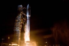
WThe Defense Support Program (DSP) is a program of the USAF that operated the reconnaissance satellites which form the principal component of the Satellite Early Warning System used by the United States.
 W
WDiscoverer 1 was the first of a series of satellites which were part of the CORONA reconnaissance satellite program. It was launched on a Thor-Agena A rocket on 28 January 1959 at 21:49:16 GMT from Vandenberg Air Force Base in California. It was a prototype of the KH-1 satellite, but did not contain either a camera or a film capsule. It was the first satellite launched toward the South Pole in an attempt to achieve polar orbit, but was unsuccessful. A CIA report, later declassified, concluded that "Today, most people believe the DISCOVERER 1 landed somewhere near the South Pole."
 W
WDiscoverer 9 was an American military reconnaissance satellite, launched on 4 February 1960 as a part of the DISCOVERER program, at 18:51:00 GMT, from Vandenberg Air Force Base on the Thor-Agena launch vehicle. The Thor cut off 20 seconds early and left the Agena without sufficient velocity or attitude control. It began tumbling and the engine shut down after only 20 seconds of operation, sending the payload into the Pacific Ocean. At liftoff, an improper disconnect of a pad umbilical also caused a loss of helium pressurization gas in the Agena's propellant tanks.
 W
WDiscoverer 14 was a spy satellite used in the Corona program managed by Advanced Research Projects Agency (ARPA) of the Department of Defense and the United States Air Force. On 19 August 1960, usable photographic film images of the Soviet Union taken by the satellite were recovered by a C-119 recovery aircraft. This was the first successful recovery of film from an orbiting satellite and the first mid-air recovery of an object returning from Earth orbit.
 W
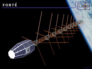
WThe Fast On-orbit Rapid Recording of Transient Events is a lightweight satellite which was launched at about 8:30 AM on August 29, 1997 into a circular 800-kilometer (500 mi) low Earth orbit which is inclined 70 degrees relative to the Earth's equator, using a Pegasus XL rocket. It was developed and launched by the Sandia National Laboratory in cooperation with Los Alamos National Laboratory, as a testbed for technologies applicable to U.S. nuclear detonation detection systems used to monitor compliance with arms control treaties, and later to study lightning from space. The project was sponsored by the United States Department of Energy, and cost about US$35 million. It utilizes optical sensors, RF sensors, and an "event classifier" in order to make observations, including monitoring Very High Frequency (VHF) lightning emissions in the ionosphere occurring from between 50 to 600 miles above the surface of the Earth, and it will be a component of the VHF Global Lightning and Severe Storm Monitor (V-GLASS) system. Its primary mission is to record and analyze bursts of RF energy rising from the surface of the Earth. FORTE is 7-foot (2.1 m) tall, weighs 470-pound (210 kg), and is the first all-composite spacecraft, its framework being made entirely of graphite-reinforced epoxy. It consists of three decks with aluminum honeycomb cores, and composite facing to support the onboard instruments.
 W
WGalactic Radiation and Background (GRAB) was the covername for a series of five Project Dyno ELINT intelligence satellites, the first surveillance satellites operated by the U.S. Naval Research Laboratory (NRL) shortly after the Cold War U-2 incident of 1960. Though only two of the five satellites made it into orbit, they returned a wealth of information on Soviet air defense radar capabilities.
 W
WISAT is a spacecraft developed by the U.S. Air Force Research Laboratory's Space Vehicles Directorate to test technology for intelligence, surveillance, and reconnaissance spacecraft.
 W
WKH-5 ARGON was a series of reconnaissance satellites produced by the United States from February 1961 to August 1964. The KH-5 operated similarly to the Corona series of satellites, as it ejected a canister of photographic film. At least 12 missions were attempted, but at least 7 resulted in failure. The satellite was manufactured by Lockheed. Launches used Thor-Agena rockets flying from Vandenberg Air Force Base, with the payload being integrated into the Agena.
 W
WBYEMAN codenamed LANYARD, the KH-6 was the unsuccessful first attempt to develop and deploy a very high-resolution optical reconnaissance satellite by the United States National Reconnaissance Office. Launches and launch attempts spanned the period from March to July 1963. The project was quickly put together to get imagery of a site near Leningrad suspected of having anti-ballistic missiles. The satellite carried Itek's "E-5" camera developed for the SAMOS program, which had been cancelled. The camera had a focal length of 1.67 m (66 in) and could discern objects on the ground 1.8 m (6 ft) in size. The ground swath of the camera was 14 x 74 km. The satellite weighed 1,500 kg, and had a single re-entry vehicle in which exposed film was returned to earth for a mid-air aircraft recovery. The KH-6 was manufactured by Lockheed Martin and launched from Vandenberg Air Force Base on Thor-Agena D rockets.
 W
WBYEMAN codenamed GAMBIT, the KH-7 was a reconnaissance satellite used by the United States from July 1963 to June 1967. Like the older CORONA system, it acquired imagery intelligence by taking photographs and returning the undeveloped film to earth. It achieved a typical ground-resolution of 2 ft (0.61 m) to 3 ft (0.91 m). Though most of the imagery from the KH-7 satellites was declassified in 2002, details of the satellite program remained classified until 2011.
 W
WThe KH-8 was a long-lived series of reconnaissance satellites of the "Key Hole" (KH) series used by the United States from July 1966 to April 1984, and also known as Low Altitude Surveillance Platform. The satellite ejected "film-bucket" canisters of photographic film that were retrieved as they descended through the atmosphere by parachute. Ground resolution of the mature satellite system was better than 4 inches (0.10 m). There were 54 launch attempts of the 3,000 kilogram satellites, all from Vandenberg Air Force Base, on variants of the Titan III rocket. Three launches failed to achieve orbit. The first one was satellite #5 on April 26, 1967 which fell into the Pacific Ocean after the Titan second stage developed low thrust. The second was satellite #35 on May 20, 1972 which suffered an Agena pneumatic regulator failure and reentered the atmosphere. A few months later, pieces of the satellite turned up in England and the US managed to arrange for their hasty return. The third failure was satellite #39 on June 26, 1973 which suffered a stuck Agena fuel valve. The Bell 8096 engine failed to start and the satellite burned up in the atmosphere. The KH-8 was manufactured by Lockheed. The camera system/satellite was manufactured by Eastman Kodak's A&O Division in Rochester, New York.
 W
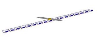
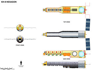
WKH-9, commonly known as Big Bird or KeyHole-9, was a series of photographic reconnaissance satellites launched by the United States between 1971 and 1986. Of twenty launch attempts by the National Reconnaissance Office, all but one were successful. Photographic film aboard the KH-9 was sent back to Earth in recoverable film return capsules for processing and interpretation. The best ground resolution achieved by the main cameras was better than 0.6 metres.
 W
WThe KH-10 was the classified designation for the reconnaissance mission and equipment of the experimental Manned Orbiting Laboratory (MOL).
 W
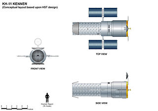
WThe KH-11 KENNEN is a type of reconnaissance satellite first launched by the American National Reconnaissance Office in December 1976. Manufactured by Lockheed in Sunnyvale, California, the KH-11 was the first American spy satellite to use electro-optical digital imaging, and so offer real-time optical observations.
 W
WThe Manned Orbiting Laboratory (MOL) was part of the United States Air Force (USAF) human spaceflight program. The project was developed from early USAF concepts of crewed space stations to be used for satellite reconnaissance purposes, and was a successor to the canceled Boeing X-20 Dyna-Soar military reconnaissance space plane. MOL evolved into a single-use laboratory, for which crews would be launched on 30-day missions, and return to Earth using a Gemini B spacecraft derived from NASA's Gemini spacecraft.
 W
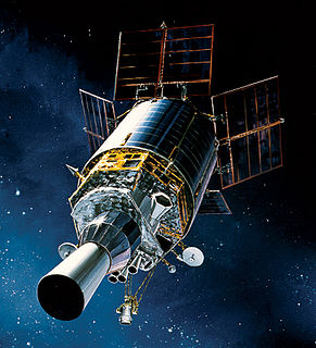
WThe Missile Defense Alarm System, or MIDAS, was a United States Air Force Air Defense Command system of 12 early-warning satellites that provided limited notice of Soviet intercontinental ballistic missile launches between 1960 and 1966. Originally intended to serve as a complete early-warning system working in conjunction with the Ballistic Missile Early Warning System, cost and reliability concerns limited the project to a research and development role. Three of the system's 12 launches ended in failure, and the remaining nine satellites provided crude infrared early-warning coverage of the Soviet Union until the project was replaced by the Defense Support Program. MiDAS represented one element of the United States's first generation of reconnaissance satellites that also included the Corona and SAMOS series. Though MIDAS failed in its primary role as a system of infrared early-warning satellites, it pioneered the technologies needed in successor systems.
 W
WThe Micro-satellite Technology Experiment (MiTEx) is a microsatellite-based mission launched into geosynchronous orbit 21 June 2006 aboard a Delta II rocket. The USAF described the mission as a "technology demonstration" for the Defense Advanced Research Projects Agency (DARPA), the United States Air Force (USAF) and the United States Navy.
 W
WThe Naval Ocean Surveillance System (NOSS) is a series of signals intelligence satellites that have conducted electronic signals intelligence for the U.S. Navy since the early 1970s. The first series of satellites were codenamed "White Cloud" or "PARCAE", while second and third-generation satellites have used the codenames "Ranger" and "Intruder".
 W
WOrion, also known as Mentor or Advanced Orion, is a class of United States spy satellites that collect signals intelligence (SIGINT) from space. Operated by the National Reconnaissance Office (NRO) and developed with input from the Central Intelligence Agency (CIA), five have been launched from Cape Canaveral on Titan IV and Delta IV rockets since 1995.
 W
WThe SAMOS or SAMOS-E program was a relatively short-lived series of reconnaissance satellites for the United States in the early 1960s, also used as a cover for the initial development of the KH-7 GAMBIT system. Reconnaissance was performed with film cameras and television surveillance from polar low Earth orbits with film canister returns and transmittals over the United States. SAMOS was first launched in 1960 from Vandenberg Air Force Base.
 W
WThe Space-Based Infrared System (SBIRS) is a consolidated system intended to meet the United States' infrared space surveillance needs through the first two to three decades of the 21st century. The SBIRS program is designed to provide key capabilities in the areas of missile warning, missile defense and battlespace characterization via satellites in geosynchronous earth orbit (GEO), sensors hosted on satellites in highly elliptical orbit (HEO), and ground-based data processing and control. SBIRS ground software integrates infrared sensor programs of the U.S. Air Force (USAF) with new IR sensors.
 W
WTACOMSAT was an communications satellite designed and built by Hughes Aircraft Corporation under the direction of the United States Air Force Space and Missile Systems Organization (SAMSO). TACOMSAT was used by the United States Department of Defense to explore the feasibility of geostationary satellite communications between ground stations comprising fixed bases, military field units, aircraft, and ships.
 W
WTacSat-1 was an experimental satellite built by the Naval Research Laboratory on behalf of the United States Department of Defense (DOD) Office of Force Transformation (OFT). It was the planned payload of the sixth launch of the SpaceX Falcon 1. It was however never launched into space. The second satellite in the series, TacSat-2, launched before TacSat-1 and this led to the cancellation of TacSat-1's launch.
 W
WTacSat-2 was an experimental satellite built by the USAF's Air Force Research Laboratory with an operational life expected to be not more than one year as part of the 'Advanced Concept Technology Demonstration' program.
 W
WTacSat-3 was the third in a series of U.S. military reconnaissance satellites. It was assembled in an Air Force Research Laboratory Space Vehicles Directorate facility at Kirtland Air Force Base, New Mexico. The TacSat satellites are all designed to demonstrate the ability to provide real-time data collected from space to combatant commanders in the field. TacSat-3 includes three distinct payloads: the Advanced Responsive Tactically Effective Military Imaging Spectrometer (ARTEMIS) hyperspectral imager, the Ocean Data Telemetry Microsatellite Link and the Space Avionics Experiment.
 W
WTacSat-4 is the fourth in a series of U.S. military experimental reconnaissance and communication satellites. The Naval Research Laboratory (NRL) is the program manager. The Office of Naval Research (ONR) sponsored the development of the payload and funded the first year of operations. The Office of the Director of Defense Research and Engineering (DDR&E) funded the standardized spacecraft bus and the Operationally Responsive Space Office (ORS) funded the launch that will be performed by the Air Force's Space and Missile Systems Center (SMC).
WDuring the second half of 2002, the Naval Research Laboratory studied the tactical application of space assets. Relatively new technologies and processes in the areas of microsatellites, affordable and quick-response launch vehicles, and the classified SIPRNET made tactical use of space assets possible in the relatively near term. The DOD's Office of Force Transformation (OFT) agreed with the core findings of the study and decided to start an Operationally Responsive Space Initiative consisting of a series of experiments. TacSat-1 is the first experiment in this OFT initiative. The TacSat-1 experiment received go-ahead on May 7, 2003.
 W
WUSA-230, also known as SBIRS-GEO 1, is an American military satellite and part of the Space-Based Infrared System. It was launched on May 7, 2011 from Cape Canaveral, atop an Atlas V rocket.
 W
WUSA-247, also known as NRO Launch 39 or NROL-39, is an American reconnaissance satellite, operated by the National Reconnaissance Office. The USA-247 launch received a relatively high level of press coverage due to the mission's choice of logo, which depicts an octopus sitting astride the globe with the motto "Nothing Is Beyond Our Reach". The logo was extensively criticized in light of the 2013 surveillance disclosures.
 W
WUSA-273, also known as SBIRS-GEO 3, is an American military satellite and part of the Space-Based Infrared System. It was launched on January 21, 2017 from Cape Canaveral, atop an Atlas V rocket.
 W
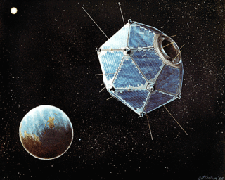
WVela was the name of a group of satellites developed as the Vela Hotel element of Project Vela by the United States to detect nuclear detonations to monitor compliance with the 1963 Partial Test Ban Treaty by the Soviet Union.