 W
WAlexandreion (Greek), or Alexandrium (Latin), called Sartaba in the Mishna and Talmud and Qarn Sartaba in Arabic, was an ancient hilltop fortress constructed by the Hasmoneans between Scythopolis and Jerusalem on a pointy barren hill towering over the Jordan Valley from the west. It was likely named after Hasmonean king Alexander Jannæus.
 W
WAn ancient underground quarry in the Jordan Valley was discovered in 2009 by University of Haifa archeologists. The quarry is located about 3 miles (5 km) north of Jericho, West Bank.
 W
WBetar fortress was an ancient, terraced farming village in the Judean highlands. The Betar fortress was the last standing Jewish fortress in the Bar Kokhba revolt of the 2nd century CE, destroyed by the Roman army of Emperor Hadrian in the year 135.
 W
WThe Bir el Qutt inscriptions are the Old Georgian Byzantine mosaic inscriptions written in the Georgian Asomtavruli script which were excavated at a St. Theodore Georgian monastery in 1952 by Italian archaeologist Virgilio Canio Corbo near Bir el Qutt, in the Judaean Desert, 6 km south-east of Jerusalem and 2 km north of Bethlehem. The whole complex was built of reddish limestone.
 W
WThe Bull Site in the West Bank is an open air ancient cult installation from 12th century BCE Canaan, and is the find spot for the Bull statuette.
 W
WEin Feshkha is a nature reserve and archaeological site on the northwestern shore of the Dead Sea, about three kilometers south of Qumran in the West Bank. Within the reserve is a group of springs of brackish water. The nature reserve consists of an open section with pools of mineral water for bathing surrounded by high foliage and a section that is closed to visitors to protect the native flora and fauna.
 W
WEl Khiam(الخیام) is an archaeological site near Wadi Khureitun in the Judaean Desert in the West Bank, on the shores of the Dead Sea.
 W
WEmmaus Nicopolis, was the Roman name for one of the towns associated with the Emmaus of the New Testament, where Jesus is said to have appeared after his death and resurrection. Emmaus was the seat of the Roman Emmaus, whereas Nicopolis was the name of the city from the 3rd century CE until the conquest of Palestine by the Muslim forces of the Rashidun Caliphate in 639. In the modern age, the site was the location of the Palestinian Arab village of Imwas, near the Latrun junction, between Jerusalem and Tel Aviv, before its destruction in 1967. The site today is inside Canada Park, a place maintained by the Israel Nature and Parks Authority, although the archaeological site has been cared for by a resident French Catholic community since 1993.
 W
WThe Eshtemoa Synagogue, located 15 km south of Hebron in as-Samu, West Bank, refers to the remains of an ancient Jewish synagogue dating from around the 4th–5th century CE.
WEt-Tell is an archaeological site in the West Bank that is popularly thought to be the biblical city of Ai.
 W
WWadi al-Far'a or Nahal Tirza is a stream in the northern West Bank that empties into the Jordan River south of Damia Bridge. It is the largest stream in the West Bank. Wadi al-Far'a is located in the rugged area of the West Bank and cuts east through the Jordan Valley, passing through the Palestinian village of Wadi al-Far'a. The Tirzah Reservoir is used to collect the floodwater of Wadi al-Far'a before it flows into the Jordan River.
 W
WGibeon was a Canaanite and Israelite city north of Jerusalem. According to Joshua 10:12 and Joshua 11:19, the pre-conquest inhabitants of Gibeon, the Gibeonites, were Hivites; according to 2 Samuel 21:2 they were Amorites. The remains of Gibeon are located on the southern edge of the Palestinian village of al-Jib.
WGilgal I is an archaeological site in the Jordan Valley, West Bank, dated to the Neolithic period. The site is located eight miles north of ancient Jericho. The features and artifacts unearthed at Gilgal I shed important light on agriculture in the Levant.
 W
WThe Hasmonean royal winter palaces are a complex of Hasmonean and Herodian buildings from the Second Temple period, which were discovered in the western plain of Jericho valley, at Tulul Abu al-'Alayiq, near the place where the Roman road connecting Jericho with Jerusalem enters Wadi Qelt. Two tells are located on either side of Wadi Qelt.
 W
WHerodium (Latin) or Herodion, also known as Har Hordus and Jabal al-Fureidis is a truncated-cone-shaped hill, 12 kilometres (7.5 mi) south of Jerusalem and 5 kilometres (3.1 mi) southeast of Bethlehem, in the Judaean Desert, West Bank. It is located between the Palestinian villages of Za'atara and Jannatah, and north of the Israeli settlement of Sdeh Bar.
 W
WHisham's Palace is an important early Islamic archaeological site of the Umayyad dynasty from the first half of the 8th century. It is located five km north of the town of Jericho, at Khirbat al-Mafjar in the West Bank. Spreading over 60 hectares, it consists of three main parts: a palace, an ornate bath complex, and an agricultural estate. Also associated with the site is a large park or agricultural enclosure (ḥayr) which extends east of the palace. An elaborate irrigation system provided the complex with water from nearby springs.
 W
WHyrcania was an ancient fortress in the Judean Desert. The site was rebuilt during the Byzantine period as a monastery called Kastellion.
 W
WKhirbet Ibziq, Kh. Ibzîk, the ruin of Ibzîk, p.n. is the name of a village with two ruins in the West Bank, separated by one kilometer and referred to in the Manasseh Hill Country Survey as Khirbet Ibziq and Khirbet Ibziq. They are about twenty kilometers northeast of Nablus. The "Lower" site is to the northeast of the "Upper" site.
 W
WThe Jericho synagogue dates to the late 6th or early 7th century CE and was discovered in Jericho in 1936. All that remains from the ancient prayer house is its mosaic floor, which contains an Aramaic inscription presenting thanks to the synagogue donors, and a well-preserved central medallion with the inscription "Shalom al Yisrael", "Peace on Israel". This led to the site also being known as Shalom Al Yisrael Synagogue.
 W
WKhirbet el-Mastarah is an archeological site that includes the largest of the complex oval compound type habitation sites located in the middle Jordan Valley in the West Bank.
 W
WKhirbet Kefireh is a modern Palestinian village just north of Qatanna, West Bank on a hilltop covering about 4-5 acres. It appears in the Survey of Western Palestine map compiled in the 1870s, and most Bible dictionaries identify it with Chephirah.
 W
WKhirbet Tibnah, is located on the West Bank, between the villages Deir Nidham and Nabi Salih.
 W
WThe Laura of Euthymius was a laura in the present-day West Bank founded by Saint Euthymius the Great (377–473) in 420. After its final abandonment in the 13th century, it was repurposed as a caravanserai and became known as Khan el-Ahmar, the Red Caravanserai, khan being an originally Persian word for inn or caravanserai.
 W
WMamre, full Hebrew name Elonei Mamre, refers to an ancient cultic shrine originally focused on a single holy tree, growing since time immemorial at Hebron in Canaan. Talmudic sources refer to the site as Beth Ilanim or Botnah, where it was one of the three most important "fairs", or market places, in Judea. Mamre lies approximately halfway between Halhul and historical Hebron, 4 kilometres north of the latter.
 W
WNaaran is an ancient Jewish village dating to the 5th and 6th century CE, located in the West Bank. Remains of the village have been excavated north of Jericho, in Ephraim, between Bethel and Jericho. The mosaic floor of a synagogue was discovered at the site featuring a large zodiac design. Naaran is mentioned in Joshua 16:7 and 1 Chronicles 7:28 as a town in the eastern part of Ephraim. Eusebius, in his Onomasticon, makes mention of the site, saying that in his day it was "a village inhabited by Jews, five [Roman] miles from Jericho." The site is also named in the writings of Josephus, under its name, and in the Midrash Rabba. Aramaic inscriptions and mosaics from the synagogue are displayed at an archaeology museum established by the Israeli archaeologist Yitzhak Magen at the Good Samaritan Inn.
 W
WAn-Nabi Samwil, also called al-Nabi Samuil, is a Palestinian village of nearly 220 inhabitants in the West Bank, within the Jerusalem Governorate, located four kilometers north of Jerusalem. The village consists of a few houses. The Palestinian population has been removed by the Israeli authorities from the village houses to a new location slightly down the hill.
WTell en-Nasbeh, likely the biblical city of Mizpah in Benjamin, is a 3.2 hectare tell located on a low plateau 12 kilometers (7.5 mi) northwest of Jerusalem in the West Bank. The site lies adjacent to an ancient roadway connecting Jerusalem with the northern hill country, which is how Tell en-Nasbeh gained importance as Judah's northern border fortress during its prime phase of occupation in the Iron Age. There are also archaeological remains at the site and in surrounding cave tombs that have been dated to the Early Bronze I, Iron I, Babylonian and Persian, Hellenistic, Roman and Byzantine Periods.
 W
WNetiv HaGdud is a moshav and Israeli settlement in the West Bank. Located in the Jordan Valley around twenty kilometres north of Jericho, it falls under the jurisdiction of Bik'at HaYarden Regional Council. In 2019 it had a population of 212.
 W
WThe politics of archaeology in Israel and Palestine refers to the significance of archaeology in the politics and social fabric of Israel and Palestine. Many important developments in Levantine archaeology have occurred within Israel and Palestine.
 W
WQubur Bene Isra'in or Qubur Bani Isra'il, are four, formerly five, huge stone structures dated to the Middle Bronze Age, which rise from a rocky plateau overlooking Wadi Qelt in the West Bank, about 3.5 miles northeast of Jerusalem, between Hizma and Geva Binyamin along Highway 437.
 W
WQumran is an archaeological site in the West Bank managed by Israel's Qumran National Park. It is located on a dry marl plateau about 1.5 km (1 mi) from the northwestern shore of the Dead Sea, near the Israeli settlement and kibbutz of Kalya.
 W
WQumran Caves are a series of caves, some natural, some artificial, found around the archaeological site of Qumran in the Judaean Desert of the West Bank. It is in these caves that the Dead Sea Scrolls were discovered.
WShechem, also spelled Sichem, was a Canaanite city mentioned in the Amarna letters, and is mentioned in the Hebrew Bible as the first capital of the Kingdom of Israel. According to Joshua 21:20–21 it was located in the tribal territorial allotment of the tribe of Ephraim. Traditionally associated with Nablus, it is now identified with the nearby site of Tell Balata in Balata al-Balad in the West Bank.
WShemouniyeh is a Heavy Neolithic archaeological site of the Qaraoun culture in the Palestinian Tubas Governorate in the northeastern West Bank, located five kilometers southwest of Tubas. It is located on a plateau over the north of the Wadi Fa'rah, a little north-west of Deishun. Nearby is the Qaraoun culture occupational site of Wadi Sallah. Large numbers of massive flint tools and debris from this factory site were found and linked to this little known culture that was identified at over 25 sites in Lebanon. Tools found included picks, adzes, borers and flake scrapers.
 W
WShiloh was an ancient city in Samaria mentioned in the Hebrew Bible and Christian Old Testament. It has been positively identified with modern Khirbet Seilun, a tell or archaeological mound, called in Modern Hebrew Tel Shiloh. It is located in the West Bank, to the west of the modern Israeli settlement town of Shilo and to the north of the Palestinian town of Turmus Ayya. Relative to other archaeological sites, it is south of ancient Lebonah and 16 kilometres (10 mi) north of Bethel.
WShuqba cave is an archaeological site near the town of Shuqba in the western Judaean Mountains in the Ramallah and al-Bireh Governorate of the West Bank.
 W
WSokho is the name given to two ancient towns in the territorial domain of Judah as mentioned in the Hebrew Bible, in what is now the West Bank. Both towns were given the name Shuweikah in Arabic, a diminutive of the Arabic shawk, meaning "thorn". The remains of both have since been identified.
 W
WSusya is the site of an ancient Jewish village in the southern Judaean Mountains of the West Bank, a Palestinian settlement established perhaps as early as the 1830s and a religious communal Israeli settlement under the jurisdiction of Har Hevron Regional Council established in 1983.
 W
WDothan was a location mentioned twice in the bible. It has been identified with Tel Dothan, also known as Tel al-Hafireh, located adjacent to the Palestinian town of Bir al-Basha, and ten kilometers southwest of Jenin, near Dotan Junction of Route 60.
 W
WTel Rumeida/Jabla al-Rahama is an agricultural and residential area in the West Bank city of Hebron. Within it lies an archaeological tell whose remains go back to the Chalcolithic period. It may have been a Canaanite royal city. Some Jewish scholars believe it was the location of biblical Hebron. It is also the location of a Palestinian neighbourhood and an Israeli settlement.
 W
WTell Balata is the site of the remains of an ancient Canaanite/Israelite city located in the Palestinian West Bank. The built-up area of Balata, a Palestinian village and suburb of Nablus, covers about one-third of the tell, and overlooks a vast plain to the east. The Palestinian village of Salim is located 4.5 kilometers (2.8 mi) to the east.
 W
WTell Maon was a biblical town in the Hebron Hills, formerly known simply as Maon, rising 863 metres (2,831 ft) above sea level. The town, now a ruin, is mentioned in Joshua 15:55 and in 1 Samuel 25:2, and is located about 6 kilometres (3.7 mi) southeast of Yatta.
WTi'inik, also transliterated Ta'anakh, Ti’innik or Taanach, is a Palestinian village in the West Bank, located 13 km Northwest of the city of Jenin in the northern West Bank.
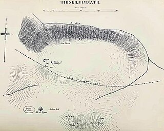
WTimnath-heres or Timnath-serah, later Thamna, was the town given by the Israelites to Joshua according to the Hebrew Bible. He requested it and the people gave it to him "at the order of the Lord". He built up the town and lived in it.
WTirzah was a town in the Samarian highlands northeast of Shechem; it is generally identified with the site of Tell el-Far'ah (North), northeast of modern city of Nablus, in the immediate vicinity of the Palestinian village of Wadi al-Far'a and the Far'a refugee camp, although Conder and Kitchener suggested that the ancient city may have actually been where Tayasir is now located, based on its phonemes. Conversely, biblical researchers, Robinson and Guérin, suggested identifying the town with Talluza.
 W
WThe Tomb of Joshua is, according to tradition, the burial site of the biblical figure Joshua. According to the biblical book bearing his name, Joshua died at the age of 110 and his burial site was in a location of his own inheritance at Timnath-serah, which is in the hill country of the Tribe of Ephraim, north of the mountain of Gaash.
 W
WThe Tower of Jericho is an 8.5-metre-tall (28 ft) stone structure, built in the Pre-Pottery Neolithic A period around 8000 BCE. It is among the earliest stone monuments of humanity.
 W
WWadi Murabba'at, also known as Nahal Darga, is a ravine cut by a seasonal stream which runs from the Judean desert east of Bethlehem past the Herodium down to the Dead Sea 18 km south of Khirbet Qumran in the West Bank. It was here in caves that Jewish fighters hid out during the Bar Kochba revolt, leaving behind documents that include some letters signed by Simon Bar Kochba.
WThe Wadi Qelt Synagogue is the name given by some to a building controversially identified by its excavator, archaeologist Ehud Netzer, as a Hasmonean-period synagogue. It is part of the royal winter palace complex built by the Hasmoneans in the warm desert oasis of Jericho, west of the town proper. It dates from between 70 and 50 BCE, and if it did indeed serve as a synagogue, it would be one of the oldest synagogues ever found.
 W
WThe Wall of Jericho was a Pre-Pottery Neolithic A (PPNA) defensive or flood protection wall suggested to date to approximately 8000 BC. If interpreted as an "urban fortification", the Wall of Jericho is the oldest city wall discovered by archaeologists anywhere in the world. It is built of undressed stones and is located at the archaeological mound known as Tell es-Sultan, in the city of Jericho on the West Bank.