 W
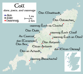
WDùn an Achaidh, sometimes Anglicised as Dun Acha, is a dun located near the village of Acha on the Inner Hebridean island of Coll. It is considered the best preserved dun on the island. The site of Dùn an Achaidh is located at grid reference NM18335456. According to local tradition, the dun was the stronghold of, and named after, the son of a Norse king. The early 20th century antiquary Erskine Beveridge considered it as one of the four most interesting fortifications on Coll.
 W
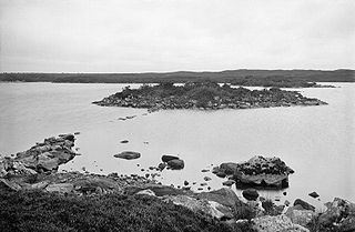
WDùn Anlaimh, also known as Dùn Amhlaidh, and Eilean nan Cinneachan, is a crannog, located within Loch nan Cinneachan on the Inner Hebridean island of Coll. Upon the crannog there are the remains of walls and several buildings. These remains are not unlike those of other fortified islands found throughout the Outer Hebrides, and it is likely that Dùn Anlaimh dates from the late Middle Ages. According to local tradition on Coll, the fort was once the home of a Norse chieftain who was defeated in battle somewhere nearby. The early 20th century antiquary Erskine Beveridge considered it as one of the four most interesting fortifications, on Coll. The site of Dùn Anlaimh is located at grid reference NM18845684. The RCAHMS classifies the site as a 'crannog' and an 'island dwelling'.
 W
WDùn Beic is a dun located on the Inner Hebridean island of Coll. It is located at grid reference NM15495644 and is thought to date to between 1000 BCE to 1000 CE. The etymology of the dun's name is uncertain; one possibility is that it could be made up of a personal name. The dun appears in local legend as being one of several fortresses held by Norsemen, who were defeated in battle against the ancestor of the Macleans of Coll. There have been several archaeological finds at Dùn Beic; these include pieces of flint, burnt bone, and fragments of incised pottery.
 W
WDùn Dubh is a hillfort, located on the Inner Hebridean island of Coll. The fort is one of three associated with a local tradition which states that they were once the fortresses of Norsemen before being defeated by a Maclean chieftain. The early 20th century antiquary Erskine Beveridge considered it as one of the four most interesting fortifications, on Coll. The site is located at grid reference NM18365942.
 W
WThere have been several town walls around Edinburgh, Scotland, since the 12th century. Some form of wall probably existed from the foundation of the royal burgh in around 1125, though the first building is recorded in the mid-15th century, when the King's Wall was constructed. In the 16th century the more extensive Flodden Wall was erected, following the Scots' defeat at the Battle of Flodden in 1513. This was extended by the Telfer Wall in the early 17th century. The walls had a number of gates, known as ports, the most important being the Netherbow Port, which stood halfway down the Royal Mile. This gave access from the Canongate which was, at that time, a separate burgh.
 W
WThe Fortified House in Scotland is a five-volume book by the Scottish author Nigel Tranter.
 W
WTotamore Dun is a dun located at grid reference NM17625713; near the settlement of Totamore, on the Inner Hebridean island of Coll. It occupies the summit of a rocky boss, on the eastern edge of the sand-hills located 300 metres north of Totamore. The dun is well protected by cliffs up to 19 metres ; although the approach from the north-northeast is almost level. The dun was protected by wall which would at one time have been about 3m thick; and would have run along the summit. This wall would have enclosed an area of about 25 by 20 metres. The current condition of the wall is, however, very poor and only a few fragments of it survive today. The entrance is 3.3 metres long by 1.2 metres wide; and is bordered on the northern side by a course of large blocks. These blocks measure up to 0.7 metres long and 0.4 metres high. Only a single facing-stone remains on the southern side of the entrance.