 W
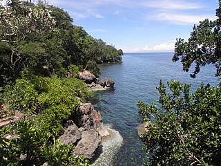
WThe Angat Watershed Forest Reserve is a conservation area that protects the drainage basin in the southern Sierra Madre range north of Metro Manila in the Philippines where surface water empties into the Angat River and its tributaries. It is spread over an area of 62,309 hectares in the eastern portion of Bulacan and northern Rizal province at an altitude of between 490 and 1,206 metres. The conservation area also extends to the provinces of Nueva Ecija and Quezon and is centered on an artificial lake created by the Angat Dam which, together with the Ipo Dam located 7.5 kilometres (4.7 mi) downstream, supply 97% of the water requirement of Metro Manila via an aqueduct system to the La Mesa Dam and Reservoir and the Balara Filtration Plant in Quezon City. The Angat Dam and Reservoir is also a major source of hydroelectricity for Metro Manila and surrounding provinces, contributing some 200 megawatts to the Luzon grid. The watershed is a popular birdwatching site and is a biodiversity hotspot containing most of the remaining closed-canopy forests in Central Luzon.
 W
WBalinsasayao Twin Lakes Natural Park is a natural park in the Philippines surrounding Lake Balinsasayao and Lake Danao in the province of Negros Oriental, 14.5 kilometres (9.0 mi) west of Dumaguete. It covers an area of 8,016.05 hectares, with heights ranging from 830 to 846 metres. The park is located in the Mount Talinis range, also known as Cuernos de Negros, in the southern portion of Negros Island, and spans across the municipalities of Valencia, Sibulan and San Jose. It was declared a protected area in 2000.
Camp John Hay is a mixed-used development which serves as a tourist destination and forest watershed reservation in Baguio, Philippines which was formerly a military base of the United States Armed Forces.
 W
WEast Guhuan Island is part of the Philippine territory adjacent to the island of Sabah in the Sulu Sea, 15 km (9.3 mi) from Mangsee Island and is part of Barangay Mangsee under the Municipality of Balabac, Province of Palawan, Philippines.
 W
WThe Initao–Libertad Protected Landscape and Seascape is a protected area in western Misamis Oriental, Philippines. At 1,300.78 hectares, the park includes the limestone forests of the old Initao National Park, locally known as Lasang, as well as their adjacent marine waters in the municipalities of Initao and Libertad. Established in 2002, it is home to the Lasang Secret Adventure Park, a theme park which is being promoted by the provincial government as an eco-tourism and corporate events destination. The park is only 27 kilometres (17 mi) southwest of the Laguindingan Airport and 59 kilometres (37 mi) west of the provincial capital Cagayan de Oro.
 W
WThe La Mesa Ecopark is a public park situated in Quezon City, Metro Manila, Philippines.
 W
WThe La Mesa Watershed Reservation is a protected area that preserves the only major watershed in Metro Manila, Philippines. Also known as the Novaliches Watershed, it contains the last remaining rainforest of its size in Metro Manila surrounding the La Mesa Dam and Reservoir, the primary source of potable drinking water for 12 million residents in the Manila metropolitan area. The area is under the joint administration, supervision and control of the Department of Environment and Natural Resources and the Metropolitan Waterworks and Sewerage System. It was established in 2007 through Proclamation No. 1336 issued by President Gloria Arroyo.
 W
WThe Lower Agno Watershed Forest Reserve is a Philippine protected area that straddles the Cordillera and Ilocos regions encompassing land from the provinces of Benguet and Pangasinan. Operated by the Lower Agno WFR Protected Area Management Board under the Department of Environment and Natural Resources, Lower Agno follows the Agno River corridor from the northern villages of Itogon to just north of the municipalities of San Manuel and San Nicolas. The reserve also known as the San Roque Watershed protects the mid-Agno River basin with its meandering river and short tributaries in a pine-forested mountainous terrain at the southern end of the Cordillera Central, around 30 kilometres (19 mi) southeast of Baguio. It is located in an important mining district and includes the reservoir of the San Roque Dam, the largest dam in the country and the prime source of water, hydropower and irrigation for surrounding regions in Luzon.
 W
WThe Magapit Protected Landscape is a protected area of forested limestone hills and grasslands in the Cagayan Valley of northern Luzon island in the Philippines. It covers an area of 3,403.62 hectares in northeastern Cagayan province straddling the municipalities of Lal-lo and Gattaran. The park was established as a game refuge and bird sanctuary on 15 August 1947 covering an initial area of 4,554 hectares declared through Administrative Order No. 10 by President Manuel Roxas. On 23 April 2000, the park was redesignated as a protected landscape area under the National Integrated Protected Areas System Act through Proclamation No. 285 signed by President Joseph Estrada. The park is a component of the Northeastern Cagayan Key Biodiversity Area and also contains the Lal-lo and Gattaran Shell Middens, a proposed World Heritage Site.
 W
WThe Mounts Palay-Palay–Mataas-na-Gulod Protected Landscape is a 3,973.13-hectare (9,817.8-acre) protected area encompassing the Palay-Palay Mountain Range in southwestern Luzon island near Manila in the Philippines. It was established on 26 October 1976 as a national park and game refuge and bird sanctuary covering an initial area of 4,000 hectares. In 2007, the national park was designated as a protected landscape area under the National Integrated Protected Areas System through Proclamation No. 1315 signed by President Gloria Arroyo. The park is the last remaining lowland rainforest in the province of Cavite and is well known for Mount Pico de Loro, a popular destination for mountaineers and hikers from Metro Manila.
 W
WThe Olango Island Group is a group of islands found in the Central Visayas region of the Philippines and is a part of Cebu Province. It comprises Olango island and 6 satellite islets namely: Sulpa, Gilutongan, Nalusuan, Caohagan, Pangan-an, and Camungi. Olango Island and its neighboring islets has a total land area of approximately 1,030 ha. The island group is divided under the jurisdiction of the city of Lapu-Lapu and the municipality of Cordova. It lies 5 km (3.1 mi) east of Mactan Island and is a major tourist destination in Cebu. It is known for its wildlife sanctuary. The entire area is the first declared Ramsar Wetland Site in the Philippines, as recognized in 1994.
 W
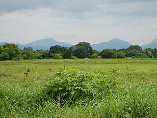
WThe Pamitinan Protected Landscape is a Philippine protected area of approximately 608 hectares in the Sierra Madre mountain range, just 34 kilometres (21 mi) northeast of Manila. It contains and protects the Montalban Gorge formed by the Marikina River that separates Mount Pamitinan and Mount Binacayan in the municipality of Rodriguez in Rizal. Established in 1996 through Proclamation No. 901 issued by President Fidel Ramos, the park is originally a component of the Mariquina Reserve founded in 1904 to protect the watershed of the Marikina River that supplied water to the city of Manila from the Wawa Dam located just above the Montalban Gorge in the early 1900s.
 W
WThe Rajah Sikatuna Protected Landscape is a protected landscape area of forested limestone hills, grasslands and natural springs in the island province of Bohol in the Central Visayas region of the Philippines. It is the largest remaining tract of natural forest in Bohol and one of the Philippines' top birdwatching sites. The park was initially gazetted a national park in 1987 covering approximately 9,023 hectares. In 2000, it was reestablished as a protected landscape under the National Integrated Protected Areas System covering its present area of 10,452.6 hectares. The park is one of the island's major tourist attractions located just south of the famous Chocolate Hills. It was named after the Bohol chieftain who entered into a blood-compact with Spanish conquistador Miguel López de Legazpi on the island in 1565.
 W
WRasa Island is a flat coral island in the Sulu Sea just off the coast of the municipality of Narra in Palawan, Philippines. It is a shallow island surrounded by mangroves and tidal flats containing one of the country's last remaining coastal forests. The island is home to the largest population of the endemic and critically endangered Philippine cockatoo in the wild in the Philippines. It was declared a protected area in 2006.
 W
WThe Samar Island Natural Park, in Samar, is the largest contiguous tract of old-growth forest in the Philippines. It is the country's largest terrestrial protected area, with an area of 333,300 hectares. The buffer is spread north to south over the island's three provinces and totals 458,700 hectares, about a third of the entire island of Samar.
WSibalom Natural Park is a 5,511.47-hectare (13,619.1-acre) protected area in the Philippines on the island of Panay in the municipality of Sibalom, Antique. It was proclaimed a natural park on 23 April 2000. It is considered as one of the last remaining lowland rainforests on Panay.
 W
WThe Upper Agno River Basin Resource Reserve is a protected area located on the southeast flank of the Cordillera Central in the Philippine province of Benguet along its border with Ifugao and Nueva Vizcaya. It is a resource reserve located high in the Central and Polis ranges protecting the headwaters of the Agno River. According to section 4 of the National Integrated Protected Areas System Act, a resource reserve is an extensive and relatively isolated area designated as such to preserve the natural resources of the area. The reserve comprises 77,561 hectares of the catchment area that feeds the Ambuklao and Binga dams, two of the country's oldest hydroelectric plants that supply power to the city of Baguio and entire Benguet province. Upper Agno is north of and contiguous with the Lower Agno Watershed Forest Reserve that preserves the immediate downstream of the Binga Dam where the Agno River is impounded by a third dam, the San Roque Dam, the largest in the Philippines and the main source of water, electric energy and irrigation for surrounding regions in Luzon.