 W
WA coastal path is a trail along a sea shore or a lake shore for pedestrians, and sometimes for cyclists or equestrians.
 W
WA footpath is a type of thoroughfare that is intended for use only by pedestrians and not other forms of traffic such as motorized vehicles, cycles, and horses. They can be found in a wide variety of places, from the centre of cities, to farmland, to mountain ridges. Urban footpaths are usually paved, may have steps, and can be called alleys, lanes, steps, etc.
 W
WAn alley or alleyway is a narrow lane, path, or passageway, often reserved for pedestrians, which usually runs between, behind, or within buildings in the older parts of towns and cities. It is also a rear access or service road, or a path, walk, or avenue in a park or garden.
 W
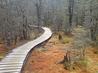
WA boardwalk is an elevated footpath, walkway, or causeway built with wooden planks that enables pedestrians to cross wet, fragile, or marshy land. They are also in effect a low type of bridge. Such timber trackways have existed since at least Neolithic times.
 W
WThe Djerring Trail is a shared use path that runs alongside the Cranbourne and Pakenham railway lines in south-eastern Melbourne, Australia. The route serves a total of 13 railway stations.
 W
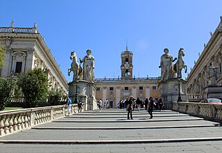
WThe cordonata is a sloping road interrupted at regular distances by low steps in the form of transversal stripes (cordoni) made of stone or bricks. It has a form almost similar to a flight of steps, but allows the transit of horses and donkeys.
 W
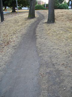
WA desire path is a path created as a consequence of erosion caused by human or animal foot traffic. The path usually represents the shortest or most easily navigated route between an origin and destination. The width and severity of erosion are often indicators of the traffic level that a path receives. Desire paths emerge as shortcuts where constructed paths take a circuitous route, have gaps, or are non-existent.
 W
WHagi Ōkan (萩往還) is a Japanese highway completed in the Edo period (1603-1868). It is 53 km in length and extends from the castle town of Hagi (萩市), capital of the old Nagato Province (長門州) to Mitajiri of old Suo Province. Hagi is on the Sea of Japan (日本海) and the highway crosses the Chugoku Mountain Range to Hofu on the Inland Sea of Japan (瀬戸内海).
 W
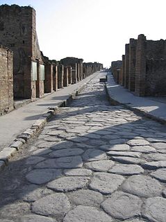
WHistoric roads are paths or routes that "have great historical importance or fame". Examples exist from prehistoric times until the early 20th century. They include ancient trackways, tracks, and roads that existed in "the period of history before the fall of the Western Roman Empire" in 476 AD. "The first roads were paths made by animals and later adapted by humans." Many historic routes, such as the Silk Road, the Amber Road, and the Royal Road of the Persian Empire, existed before the Christian era and covered great distances.
 W
WA linear park is a park in an urban or suburban setting that is substantially longer than it is wide. Some are rail trails, that are disused railroad beds converted to recreational use, while others use strips of public land next to canals, streams, extended defensive walls, electrical lines, highways and shorelines. They are also often described as greenways. In Australia, a linear park along the coast is known as a foreshoreway.
 W
WA long-distance trail is a longer recreational trail mainly through rural areas used for hiking, backpacking, cycling, horse riding or cross-country skiing. They exist on all continents except Antarctica.
 W
WA mass path is a pedestrian track or road connecting destinations frequently used by rural communities, traditionally leading to a church celebrating Sunday Mass. They were most common during the centuries that preceded motorised transportation in Western Europe, and in particular the British Isles, and the Netherlands (where such a path is called kerkenpad.
 W
WA plank road is a road composed of wooden planks or puncheon logs. Plank roads were commonly found in the Canadian province of Ontario as well as the Northeast and Midwest of the United States in the first half of the 19th century. They were often built by turnpike companies.
 W
WPortuguese pavement is a traditional-style pavement used for many pedestrian areas in Portugal. It consists of small flat pieces of stones arranged in a pattern or image, like a mosaic. It can also be found in Olivença and throughout former Portuguese colonies. Portuguese workers are also hired for their skill in creating these pavements in places such as Gibraltar. Being usually used in sidewalks, it is in town squares and atriums that this art finds its deepest expression.
 W
WA sandō in Japanese architecture is the road approaching either a Shinto shrine or a Buddhist temple. Its point of origin is usually straddled in the first case by a Shinto torii, in the second by a Buddhist sanmon, gates which mark the beginning of the shrine's or temple territory. The word dō (道) can refer both to a path or road, and to the path of one's life's efforts. There can also be stone lanterns and other decorations at any point along its course.
 W
WA sculpture trail - also known as "a culture walk" or "art trail" - is a walkway through open-air galleries of outdoor sculptures along a defined route with sequenced viewings encountered from planned preview and principal sight lines.
 W
WA sidewalk, pavement, footpath, or footway, is a path along the side of a road. Usually constructed of concrete or asphalt, it is designed for pedestrians. A sidewalk may accommodate moderate changes in grade (height) and is normally separated from the vehicular section by a curb. There may also be a median strip or road verge either between the sidewalk and the roadway or between the sidewalk and the boundary.
 W
WA towpath is a road or trail on the bank of a river, canal, or other inland waterway. The purpose of a towpath is to allow a land vehicle, beasts of burden, or a team of human pullers to tow a boat, often a barge. This mode of transport was common where sailing was impractical due to tunnels and bridges, unfavourable winds, or the narrowness of the channel.
 W
WIn American English, walkway is a composite or umbrella term for all engineered surfaces or structures which support the use of trails.
 W
WWater Sky Garden is a sculptural environment designed by artist Janet Echelman. The garden is located outside the Richmond Olympic Oval, an official venue for the 2010 Vancouver Olympic Games. The installation consists of a wetland treatment pond, 300 ft. boardwalk, two 52 ft. pedestrian bridges, two net sculptures, and a fountain.
 W
WWayfinding encompasses all of the ways in which people orient themselves in physical space and navigate from place to place.