 W
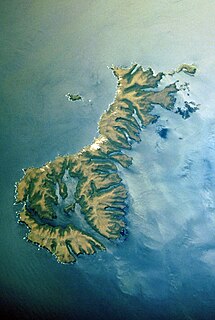
WArapaoa Island, formerly known as Arapawa Island, is a small island located in the Marlborough Sounds, at the north east tip of the South Island of New Zealand. The island has a land area of 75 km2. Queen Charlotte Sound defines its western side, while to the south lies Tory Channel, which is on the sea route from Wellington in the North Island to Picton. Cook Strait's narrowest point is between Arapaoa Island's Perano Head and Cape Terawhiti in the North Island.
 W
WThe Auckland Islands are an archipelago of New Zealand, lying 465 kilometres (290 mi) south of the South Island. The main Auckland Island, occupying 510 km2 (200 sq mi), is surrounded by smaller Adams Island, Enderby Island, Disappointment Island, Ewing Island, Rose Island, Dundas Island, and Green Island, with a combined area of 626 km2 (240 sq mi). The islands have no permanent human inhabitants.
 W
WBanks Peninsula is a peninsula of volcanic origin on the east coast of the South Island of New Zealand. It has an area of approximately 1,150 square kilometres (440 sq mi) and encompasses two large harbours and many smaller bays and coves. The South Island's largest city, Christchurch, is immediately north of the peninsula.
 W
WThe Bay of Plenty is a region of New Zealand, situated around a bight of the same name in the northern coast of the North Island. The bight stretches 260 km from the Coromandel Peninsula in the west to Cape Runaway in the east. The Bay of Plenty Region, governed by the Bay of Plenty Regional Council, incorporates several large islands in the bay, in addition to the mainland area. Called Te Moana-a-Toi in the Māori language after Toi, an early ancestor, the name 'Bay of Plenty' was bestowed by James Cook in 1769 when he noticed the abundant food supplies at several Māori villages there, in stark contrast to observations he had made earlier in Poverty Bay.
 W
WCook Strait separates the North and South Islands of New Zealand. The strait connects the Tasman Sea on the northwest with the South Pacific Ocean on the southeast, and runs next to the capital city, Wellington. It is 22 kilometres (14 mi) wide at its narrowest point, and is considered one of the most dangerous and unpredictable waters in the world. Regular ferry services run between Picton in the Marlborough Sounds and Wellington.
 W
WDoubtless Bay is a bay situated on the east coast of the Northland Region, north-east of Kaitaia, in New Zealand.
 W
WFoveaux Strait (Te Ara a Kiwa or Te Ara a Kewa separates Stewart Island, New Zealand's third largest island, from the South Island. According to a Maori legend, the strait was created by Kewa the obedient whale when traditional Maori ancestor Kiwa summoned the whale to create a waterway. Three large bays, Te Waewae Bay, Oreti Beach and Toetoes Bay, sweep along the strait's northern coast, which also hosts Bluff township and harbour. Across the strait lie the Solander Islands, Stewart Island, Dog Island and Ruapuke Island. The strait is about 130 km long, and it widens and deepens from east to west. The strait lies within the continental shelf area of New Zealand, and was probably dry land during the Pleistocene epoch.
 W
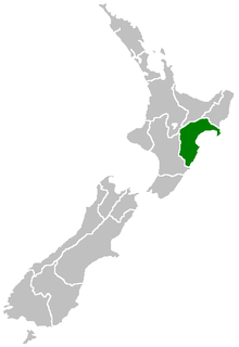
WHawke's Bay Region is a local government region of New Zealand on the east coast of the North Island. The region's name derives from Hawke Bay, which was named by Captain James Cook in honour of Admiral Edward Hawke. The region is governed by Hawke's Bay Regional Council.
 W
WKapiti Island is an island about 5 km (3 mi) off the west coast of the lower North Island of New Zealand. It is 10 kilometres (6.2 mi) long, running southwest/northeast, and roughly 2 kilometres (1.2 mi) wide, being more or less rectangular in shape, and has an area of 19.65 km2 (7.59 sq mi).
WThe small town of Karitane is located within the limits of the city of Dunedin in New Zealand, 35 kilometres to the north of the city centre.
 W
WMoeraki is a small fishing village on the east coast of the South Island of New Zealand. It was once the location of a whaling station. In the 1870s, local interests believed it could become the main port for the north Otago area and a railway line, the Moeraki Branch, was built to the settlement and opened in 1877. However, the port could not compete with Oamaru and the lack of traffic as well as stability problems caused by difficult terrain led to the closure of the railway in 1879 after only two years of operation.
 W
WMoutohora Island or Whale Island is a small uninhabited island located off the Bay of Plenty coast of New Zealand's North Island, about 9 kilometres (5.6 mi) north of the town of Whakatane. The 1.43 km2 (0.55 sq mi) island is a remnant of a complex volcano which has eroded, leaving two peaks. This is still an area of volcanic activity and there are hot springs on the island in Sulphur Valley, McEwans Bay, and Sulphur Bay.
 W
WThe Northland Region is the northernmost of New Zealand's 16 local government regions. New Zealanders sometimes refer to it as the Winterless North because of its mild climate. The main population centre is the city of Whangārei, and the largest town is Kerikeri. At the 2018 New Zealand census Northland recorded a surprising population growth spurt of 18.1% since the previous 2013 census, placing it as the fastest growing region of New Zealand, ahead of other strong growth regions such as the Bay of Plenty and Waikato.
 W
WThe Otago Peninsula is a long, hilly indented finger of land that forms the easternmost part of Dunedin, New Zealand. Volcanic in origin, it forms one wall of the eroded valley that now forms Otago Harbour. The peninsula lies south-east of Otago Harbour and runs parallel to the mainland for 20 km, with a maximum width of 9 km. It is joined to the mainland at the south-west end by a narrow isthmus about 1.5 km wide.
 W
WOtakou is a settlement within the boundaries of the city of Dunedin, New Zealand. It is located 25 kilometres from the city centre at the eastern end of Otago Peninsula, close to the entrance of Otago Harbour. Though a small fishing village, Otakou is important in the history of Otago for several reasons. The settlement is the modern centre and traditional home of the Ōtākou rūnanga (assembly) of Ngāi Tahu. In 1946 Otakou Fisheries was founded in the township; this was later to become a major part of the Otago fishing industry.
 W
WPeraki, a Māori language place name with an initial spelling of Pireka, is a bay on the south side of Banks Peninsula, New Zealand. It is the site of the first permanent European settlement in Canterbury. George Hempelman, a Prussian whaler, established a whaling station in the bay in 1835, and from 1837 lived there permanently. Peraki has a small cemetery, one of the earliest European cemeteries in New Zealand.
 W
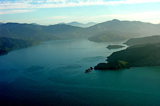
WTe Whanganui / Port Underwood is a sheltered harbour which forms the north-east extension of Cloudy Bay at the northeast of New Zealand's South Island, on the east coast of the Marlborough Sounds. With only a relatively narrow entrance to the south-south-east it is sheltered from almost all winds. Originally considered part of Cloudy Bay the port was named after Joseph Underwood of the shipping firm Kabel and Underwood in the early 19th century.
 W
WPoverty Bay is the largest of several small bays on the east coast of New Zealand's North Island to the north of Hawke Bay. It stretches for 10 kilometres (6 mi) from Young Nick's Head in the southwest to Tuaheni Point in the northeast. The city of Gisborne is located on the northern shore of the bay and the small settlement of Muriwai is located at the bay's southern end. The name is often used by extension to refer to the entire area surrounding the city of Gisborne. Poverty Bay is the home of the Māori iwi (tribes) Te Aitanga-a-Māhaki, Rongowhakaata and Ngāi Tāmanuhiri.
 W
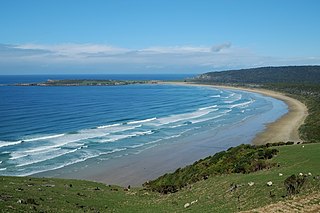
WTautuku Peninsula is a rocky headland in the Catlins on the south coast of Otago on the South Island of New Zealand. It is located 25 km (15 mi) east of Waikawa, at the western end of Tautuku Bay.
 W
WWaikouaiti is a small town in East Otago, New Zealand, within the city limits of Dunedin. The town is close to the coast and the mouth of the Waikouaiti River.
 W
WWairoa is a town and territorial authority district in New Zealand's North Island. The town is the northernmost in the Hawke's Bay region, and is located on the northern shore of Hawke Bay at the mouth of the Wairoa River and to the west of Mahia Peninsula. It is 118 kilometres (73 mi) northeast of Napier, and 92 kilometres (57 mi) southwest of Gisborne. It is the largest town in the district of Wairoa, and is one of three towns in New Zealand where Māori outnumber other ethnicities, with 62.29% of the population identifying as Māori.