 W
WNew Zealand has 44 marine reserves spread around the North, the South Island, and neighbouring islands, and on outlying island groups. They are governed by the Marine Reserves Act 1971 and administered by the Department of Conservation with assistance from the Ministry of Fisheries, New Zealand Customs and the New Zealand Defence Forces.
 W
WThe Akaroa Marine Reserve, an area of 512.15 hectares at the entrance to the Akaroa Harbour in New Zealand, was approved in 2013 after a lengthy campaign, and established in 2014.
 W
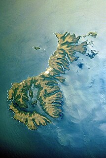
WThe Auckland Islands are an archipelago of New Zealand, lying 465 kilometres (290 mi) south of the South Island. The main Auckland Island, occupying 510 km2 (200 sq mi), is surrounded by smaller Adams Island, Enderby Island, Disappointment Island, Ewing Island, Rose Island, Dundas Island, and Green Island, with a combined area of 626 km2 (240 sq mi). The islands have no permanent human inhabitants.
 W
WCape Rodney-Okakari Point Marine Reserve is a 5.5 km2 (2.1 sq mi) protected area in the North Island of New Zealand. Goat Island lies within the reserve and Leigh is the closest town. Auckland University operates Leigh Marine Laboratory at the reserve. It was created in 1975 as the first marine reserve in New Zealand.
 W
WGoat Island or Te Hāwere-a-Maki is a tiny island in New Zealand located close to the North Island coast, north of Auckland, northeast of Warkworth, and directly west of Little Barrier Island. It is within Cape Rodney-Okakari Point Marine Reserve, New Zealand's first marine reserve.
 W
WThe Horoirangi Marine Reserve, sometimes referred to as the Glenduan Marine Reserve, is situated to the north east of Nelson in New Zealand. It stretches along the coast from the northern end of Boulder Bank to just south of Cable Bay.
 W
WKapiti Marine Reserve is a protected area on the west coast of the North Island of New Zealand. It lies between Paraparaumu and Waikanae beaches and Kapiti Island and is 30 kilometres north of the capital city Wellington.
 W
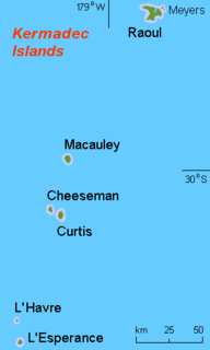
WThe Kermadec Islands are a subtropical island arc in the South Pacific Ocean 800–1,000 km (500–620 mi) northeast of New Zealand's North Island, and a similar distance southwest of Tonga. The islands are part of New Zealand, 33.6 km2 (13.0 sq mi) in total area and uninhabited, except for the permanently manned Raoul Island Station, the northernmost outpost of New Zealand.
 W
WThe Long Bay-Okura Marine Reserve is a 980-hectare (2,400-acre) protected area at Long Bay on the North Shore in the Auckland Region of New Zealand. It was created by Order in Council in 1995.
 W
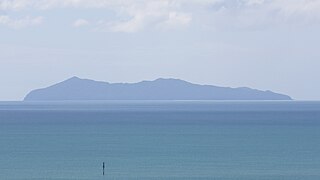
WMayor Island is a dormant shield volcano located off the Bay of Plenty coast of New Zealand's North Island. It lies 35 kilometres (22 mi) north of Tauranga and covers 13 km2 (5 sq mi). The island is quite steep along its coast and rises to 355 metres (1,165 ft) above sea level. A saddle about 75 metres (246 ft) deep separates it from the North Island, while the other side of the volcano rises from the seafloor some 400–500 metres (1,312–1,640 ft) beneath the waves. The island is believed to have risen from the sea about 7000 years ago. Hot springs abound, and there are two small crater lakes, Green Lake and Black Lake. These lie within two overlapping calderas formed in explosive eruptions 36,000 and 6,340 years ago. Mayor Island has exhibited a wide range of eruptive styles, including fire fountains, Strombolian explosions, extrusion of lava domes, phreatomagmatic explosions, Plinian falls and ignimbrite. The most recent lava flows have been dated at between 500 and 1,000 years old.
WMotu Manawa-Pollen Island Marine Reserve is a 501 hectares (1.93 sq mi) protected area in the Waitemata Harbour in Auckland, New Zealand, established in 1995. It includes the entire area between Rosebank Peninsula and Waterview, and surrounds Pollen and Traherne Islands. Its northeastern boundary runs roughly parallel to Rosebank Peninsula, from the mouth of the Oakley Creek estuary. Its northernmost boundary is north of Pollen Island, at the same latitude as the tip of Point Chevalier. Its westernmost point is in the mouth of the Whau River, between the tip of Rosebank Peninsula and Te Atatū.
WPohatu Marine Reserve is a 215 ha marine reserve centered on Flea Bay and lies between Ounu-hau Point and Redcliffe Point on Banks Peninsula in the Canterbury region of New Zealand. It was formally notified in 1999.
WThe Poor Knights Islands Marine Reserve is a protected area off the coast of the North Island of New Zealand. The reserve, established in 1981 and covering an area of 1,890 ha, is administered by the Department of Conservation. It surrounds the Poor Knights Islands and adjacent rock stacks Sugarloaf Rock and High Peak Rocks. It is one of the world's ten most popular sites for scuba diving. with dive trips regularly leaving from the town of Tutukaka.
 W
WThe Sugar Loaf Islands are a collection of five small uninhabited islands and several sea stacks near Port Taranaki, Taranaki, New Zealand.
WTapuae Marine Reserve is a marine reserve created in 2008 off the Taranaki coast of New Zealand.
 W
WTaputeranga Marine Reserve is a legally protected area of sea and coast along the southern edge of Wellington, in New Zealand. It was officially opened in September 2008. The reserve covers 855 hectares and includes all foreshore up to mean high water spring.
 W
WTe Paepae o Aotea, also known the Volkner Rocks, are a group of andesitic rock stacks and pinnacles located 5 kilometres (3.1 mi) northwest of Whakaari/White Island in New Zealand's Bay of Plenty. They reach 113 metres above sea level, while the saddle separating them from Whakaari/White Island is over 200 metres deep.
 W
WTe Whanganui-A-Hei Marine Reserve is in the southern part of Mercury Bay on the Coromandel Peninsula in New Zealand. On the coast of the mainland it runs from Cook Bluff in the north-west to the northern end of Hahei Beach in the south-east. Its offshore extremes run from Motukorure Island through Waikaranga Island to Okorotere Island and the northern end of Mahurangi Island. It covers an area of 840 hectares.
WTonga Island Marine Reserve is a protected area on the northern coast of the South Island of New Zealand. It surrounds Tonga Island and is next to the Abel Tasman National Park. The marine reserve was created in 1993 and covers an area of 1,835 hectares (7.08 sq mi).
WMayor Island is a dormant shield volcano located off the Bay of Plenty coast of New Zealand's North Island. It lies 35 kilometres (22 mi) north of Tauranga and covers 13 km2 (5 sq mi). The island is quite steep along its coast and rises to 355 metres (1,165 ft) above sea level. A saddle about 75 metres (246 ft) deep separates it from the North Island, while the other side of the volcano rises from the seafloor some 400–500 metres (1,312–1,640 ft) beneath the waves. The island is believed to have risen from the sea about 7000 years ago. Hot springs abound, and there are two small crater lakes, Green Lake and Black Lake. These lie within two overlapping calderas formed in explosive eruptions 36,000 and 6,340 years ago. Mayor Island has exhibited a wide range of eruptive styles, including fire fountains, Strombolian explosions, extrusion of lava domes, phreatomagmatic explosions, Plinian falls and ignimbrite. The most recent lava flows have been dated at between 500 and 1,000 years old.
 W
WThe Ulva Island/Te Wharawhara Marine Reserve is a 1,075 ha marine reserve located near Ulva Island/Te Wharawhara in Paterson Inlet, Stewart Island, New Zealand. It was established in 2004.
 W
WThe Whangarei Harbour Marine Reserve is a protected area in the North Island of New Zealand. It was established in 2006 and measures 236.5 ha over two sites. The students and faculty of the nearby Kamo High School played an important role in establishing this reserve.