 W
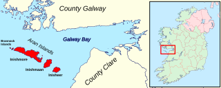
WThe Aran Islands or The Arans are a group of three islands located at the mouth of Galway Bay, on the west coast of Ireland, with a total area around 46 km2 (18 sq mi). They constitute the barony of Aran in County Galway, Ireland.
 W
WAughris is a coastal townland in County Sligo, in the west of Ireland. It is also the name given to a prominent headland that includes the townlands of Aughris, Garryduff, Kilrusheighter and Rathglass. The area has been settled since at least medieval times and there are several archaeological remains in the vicinity.
 W
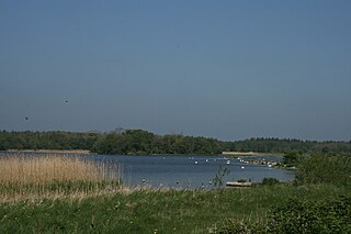
WBallynakill Lough is a lake in Connemara, County Galway, Ireland. The lake is fed by a short stream connected to the nearby Atlantic Ocean. Tooreen Bog is located on the lakes south coast. The village of Cleggan is located to the west.
 W
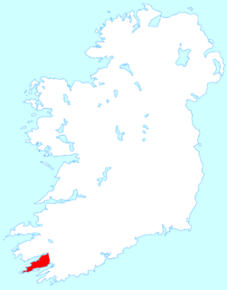
WBeara or the Beara Peninsula is a peninsula on the south-west coast of Ireland, bounded between the Kenmare "river" to the north side and Bantry Bay to the south. It contains two mountain ranges running down its centre: the Caha Mountains and the Slieve Miskish Mountains. The northern part of the peninsula from Kenmare to near Ardgroom is in County Kerry, while the rest forms the barony of Bear in County Cork.
 W
WBooterstown Marsh, a Nature Reserve, is located in Booterstown, County Dublin, between the coastal railway line and the Rock Road. It is an area of salt marsh and muds, with brackish water. It includes the only salt marsh, and the only bird sanctuary, in south Dublin Bay. It lies just outside the boundary of Dublin city, and just north of Booterstown DART station and its car park.
 W
WCarlingford Lough is a glacial fjord or sea inlet that forms part of the border between Northern Ireland to the north and the Republic of Ireland to the south. On its northern shore is County Down and on its southern shore is County Louth. At its extreme interior angle it is fed by the Newry River and the Newry Canal.
 W
WThe Cliffs of Moher are sea cliffs located at the southwestern edge of the Burren region in County Clare, Ireland. They run for about 14 kilometres. At their southern end, they rise 120 metres (390 ft) above the Atlantic Ocean at Hag's Head, and, 8 kilometres to the north, they reach their maximum height of 214 metres (702 ft) just north of O'Brien's Tower, a round stone tower near the midpoint of the cliffs, built in 1835 by Sir Cornelius O'Brien, then continue at lower heights. The closest settlements are the villages of Liscannor 6 km to the south, and Doolin 7 km to the north.
 W
WCoole Park is a nature reserve of approximately 1,000 acres (4 km2) located a few miles west of Gort, County Galway, Ireland. It is managed by the Irish National Parks & Wildlife Service, part of the Department of Arts, Heritage and the Gaeltacht. The park is in a low–lying karstic limestone area characterised by seasonal lakes, known as turloughs, which are almost unique to Ireland. It has extensive woodlands. There are 6 kilometres of signposted nature trails plus a formal late 18th century walled garden.
 W
WCork Harbour is a natural harbour and river estuary at the mouth of the River Lee in County Cork, Ireland. It is one of several which lay claim to the title of "second largest natural harbour in the world by navigational area". Other contenders include Halifax Harbour in Canada, Trincomalee Harbour in Sri Lanka and Poole Harbour in England.
 W
WLough Corrib is a lake in the west of Ireland. The River Corrib or Galway River connects the lake to the sea at Galway. It is the largest lake within the Republic of Ireland and the second largest on the island of Ireland. It covers 176 km² and lies mostly in County Galway with a small area of its northeast corner in County Mayo.
 W
WThe Dingle Peninsula is the northernmost of the major peninsulas in County Kerry. It ends beyond the town of Dingle at Dunmore Head, the westernmost point of Ireland and arguably Europe.
 W
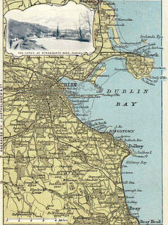
WDublin Bay is a C-shaped inlet of the Irish Sea on the east coast of Ireland. The bay is about 10 kilometres wide along its north–south base, and 7 km in length to its apex at the centre of the city of Dublin; stretching from Howth Head in the north to Dalkey Point in the south. North Bull Island is situated in the northwest part of the bay, where one of two major inshore sand banks lay, and features a 5 km long sandy beach, Dollymount Strand, fronting an internationally recognised wildfowl reserve. Many of the rivers of Dublin reach the Irish Sea at Dublin Bay: the River Liffey, with the River Dodder flow received less than 1 km inland, River Tolka, and various smaller rivers and streams.
 W
WDunfanaghy is a small town, former fishing port, and commercial centre on the north coast of County Donegal, Ireland. It lies on Donegal's North West coast, specifically the west side of Sheephaven Bay, on the N56 road. The town has its own dedicated website, which gives information about the town and the surrounding area.
 W
WFanad is a peninsula that lies between Lough Swilly and Mulroy Bay on the north coast of County Donegal, Ireland. The origins of the name Fanad are lost in time thought there is some speculation that the name derives from an old Gaelic word Fana for "sloping ground". It is also referred to as Fannet or Fannett in older records. There are an estimated 700 people living in Fanad and 30% Irish speakers.
 W
WGlenveagh is the second largest national park in Ireland. National parks in Ireland conform to IUCN standards.
 W
WHowth Head is a peninsula northeast of the city of Dublin in Ireland, within the governance of Fingal County Council. Entry to the headland is at Sutton while the village of Howth and the harbour are on the north-eastern face. Most of Howth Head is occupied by the Hill of Howth, though there are other regions, such as the tombolo at Sutton, extensive beaches on the northern shores, and small ones in other parts. The Baily Lighthouse is on the southeastern part of Howth Head. Nearby are the districts of Baldoyle and Portmarnock, and adjacent is the nature reserve of North Bull Island.
 W
WInishmurray is an uninhabited island situated 7 km (4 mi) off the coast of County Sligo, Ireland.
 W
WInishtrahull or 'Inis Trá Thuathail' as used in County Donegal by speakers of Ulster Irish, meaning 'Island with the beach on the opposite or contrary side' as is clear when compared to other islands on the Irish coast, where the landing place always faces the mainland, is the most northerly island of Ireland. It has an area of 0.34 square kilometres (0.13 sq mi) and lies about 10 kilometres (6.2 mi) north-east of Malin Head, County Donegal. The most northerly landfall of Ireland, the Tor Beg rock, is another one kilometre to the north. Inishtrahull is home to Ireland's northernmost lighthouse. The island had a resident community until 1929 and the lighthouse was manned until 1987. Today it is uninhabited and has been designated a protected area due to its wildlife.
 W
WIreland's Eye is a small uninhabited island off the coast of County Dublin, Ireland, situated directly north of Howth Harbour. The island is easily reached by regular tourist boats. The island is currently part of the county of Fingal, for administrative purposes, but was at one time part of the city of Dublin. The island was for centuries part of the Howth Estate, but was sold to the Tetrarch investment group in a deal announced in 2018.
 W
WLittle Skellig is an island in the Atlantic Ocean, 11 km south-west of Valentia Island in County Kerry, Ireland.
 W
WLough Ennell is a lake near the town of Mullingar, County Westmeath, Ireland. It is situated beside the N52 road, off the Mullingar/Kilbeggan road. The lake is part of the Lough Ennell Special Protection Area. It is 6.5 km (4.0 mi) long by 2 km (1.2 mi) wide, with an area of about 12 km2 (4.6 sq mi). Lough Ennell has a large area of shallow water with nearly two-thirds of its area being less than 25 feet and almost half of it being under 10 ft (3.0 m) deep. The lake produced Ireland's largest ever lake brown trout at 26 lbs (11.8 kg). Lough Ennell is dotted with islands, many of which have now become attached to the shoreline as the levels of the lake have changed.
 W
WLough Gara is a lake in Counties Sligo and Roscommon, Ireland. It is an Important Bird Area protecting 1,788 ha of which most is covered by a Ramsar Site.
 W
WLough Owel is a mesotrophic lough in the Midlands of Ireland, situated north of Mullingar, the county town of Westmeath. It has a maximum depth of 21 metres (69 ft). Water from Lough Owel feeds the Royal Canal, a canal crossing Ireland from Dublin to the River Shannon. The lake is close to the N4 primary road.
 W
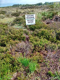
WMongan Bog is a peat bog in County Offaly, Ireland. The bog is located east of Clonmacnoise, a monastic site on the river Shannon. A nature reserve covering about 120 ha protects part of the bog.
 W
WPuffin Island is an uninhabited steep rocky island lying off the coast of the Iveragh Peninsula, County Kerry, Ireland.
 W
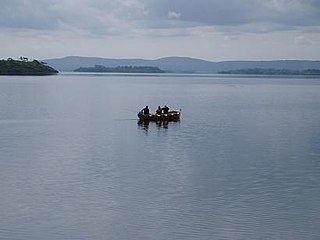
WLough Ree is a lake in the midlands of Ireland, the second of the three major lakes on the River Shannon. Lough Ree is the second largest lake on the Shannon after Lough Derg. The other two major lakes are Lough Allen to the north, and Lough Derg to the south. There are also several minor lakes along the length of the river. The lake serves as a border between the counties of Longford and Westmeath on the eastern side and County Roscommon in the province of Connacht on the western side. The lake is popular for fishing and boating. The lake supports a small commercial eel fishery and is locally famous for its eels on wheels truck. The town of Athlone is situated at the southern end of the lake, and has a harbour for boats going out on the lake. The small town of Lanesboro is at the northern end of the lake.
 W
WLough Sheelin, in standard Irish Loch Síleann, is a limestone freshwater lough (lake) in central Ireland. The lake is a part of the River Inny course, and ultimately of the Shannon system.
 W
WThe Skellig Islands, once known as "the Skellocks", are two small, steep, and rocky islands lying about 13 km (8 mi) west of Bolus Head on the Iveragh Peninsula in County Kerry, Ireland. The larger of the two is Skellig Michael which, together with Little Skellig, is at the centre of a 364-hectare (899-acre) Important Bird Area established by BirdWatch Ireland in 2000. Skellig Michael is also famous for an early Christian monastery that is a UNESCO World Heritage Site.
 W
WTory Island, or simply Tory, is an island 14.5 kilometres off the north-west coast of County Donegal, Ireland, and is the most remote inhabited island of Ireland. It is also known in Irish as Oileán Thoraí or, historically, Oileán Thúr Rí. The word Tory comes from the Middle Irish word Tóraidhe which means bandit.