 W
WFlooded grasslands and savannas is a terrestrial biome of the WWF biogeographical system, consisting of large expanses or complexes of flooded grasslands. These areas support numerous plants and animals adapted to the unique hydrologic regimes and soil conditions. Large congregations of migratory and resident waterbirds may be found in these regions. However, the relative importance of these habitat types for these birds as well as more vagile taxa typically varies as the availability of water and productivity annually and seasonally shifts among complexes of smaller and larger wetlands throughout a region.
 W
WThe Amur meadow steppe ecoregion is spread over two sections of the middle Amur River valley in the Russian Far East. The terrain is one of flat floodplains on alluvial soil. Due to high water table and frequent flooding, the area has remained relatively forest-free, and is today characterized by extensive wetlands of bogs and grasslands. The area remained ice-free during the Pleistocene glaciation, creating a refuge for many plant and animal species. It has an area of 123,283 square kilometres (47,600 sq mi).
 W
WThe Barley Barber Swamp, once a vast Bald Cypress forest and waterway in the Greater Everglades watershed, is a 450-acre (180 ha) parcel of land surrounded by Florida Power & Light's (FPL) Martin County power plant. The swamp is located just over a mile east of Lake Okeechobee and due west of Indiantown, Florida. The old-growth cypress swamp is named after Barley Barber, a man who lived in the area at the turn of the 20th century. Little is known of the man Barley Barber except that he left the region after he had "trouble with the law."
 W
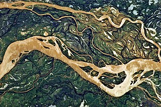
WThe Barotse Floodplain also known as the Bulozi Plain, Lyondo or the Zambezi Floodplain is one of Africa's great wetlands, on the Zambezi River in the Western Province of Zambia. It is a designated Ramsar site, regarded as being of high conservation value.
 W
WBeach Meadows are coastal meadows influenced by the presence of the nearby sea.
 W
WThe Bohai Sea saline meadow ecoregion covers the coastal deltas of the Yellow River and the Luan River where they enter the Bohai Sea in China. The saline meadows and intertidal mudflats provide an important stopping-over point for birds migrating on the East Asian–Australasian Flyway. The region is under heavy ecological pressure from human development.
 W
WLake Chad is a historically large, shallow, endorheic lake in Africa, which has varied in size over the centuries. According to the Global Resource Information Database of the United Nations Environment Programme, it shrank by as much as 95% from about 1963 to 1998, the lowest was in 1986, with 279km2, but "the 2007 (satellite) image shows significant improvement over previous years." Lake Chad is economically important, providing water to more than 30 million people living in the four countries surrounding it on the central part of the Sahel. It is the largest lake in the Chad Basin.
 W
WThe Colorado River Delta is the region where the Colorado River flows into the Gulf of California in eastern Mexicali Municipality in the north of the state of Baja California in northwesternmost Mexico. The delta is part of a larger geologic region called the Salton Trough. Historically, the interaction of the river's flow and the ocean's tide created a dynamic environment, supporting freshwater, brackish, and saltwater species. Within the delta region, the river split into multiple braided channels and formed a complex estuary and terrestrial ecosystems. The use of water upstream and the accompanying reduction of freshwater flow has resulted in the loss of most of the wetlands of the area, as well as drastic changes to the aquatic ecosystems. However, a scheme is currently in place which aims to rejuvenate the wetlands by releasing a pulse of water down the river delta.
 W
WThe Everglades is a natural region of tropical wetlands in the southern portion of the U.S. state of Florida, comprising the southern half of a large drainage basin within the Neotropical realm. The ecosystem it forms is not presently found anywhere else on earth. The system begins near Orlando with the Kissimmee River, which discharges into the vast but shallow Lake Okeechobee. Water leaving the lake in the wet season forms a slow-moving river 60 miles (97 km) wide and over 100 miles (160 km) long, flowing southward across a limestone shelf to Florida Bay at the southern end of the state. The Everglades experience a wide range of weather patterns, from frequent flooding in the wet season to drought in the dry season. Throughout the 20th century, the Everglades suffered significant loss of habitat and environmental degradation.
 W
WThe geography and ecology of the Everglades involve the complex elements affecting the natural environment throughout the southern region of the U.S. state of Florida. Before drainage, the Everglades were an interwoven mesh of marshes and prairies covering 4,000 square miles (10,000 km2). The Everglades is simultaneously a vast watershed that has historically extended from Lake Okeechobee 100 miles (160 km) south to Florida Bay, and many interconnected ecosystems within a geographic boundary. It is such a unique meeting of water, land, and climate that the use of either singular or plural to refer to the Everglades is appropriate. When Marjory Stoneman Douglas wrote her definitive description of the region in 1947, she used the metaphor "River of Grass" to explain the blending of water and plant life.
 W
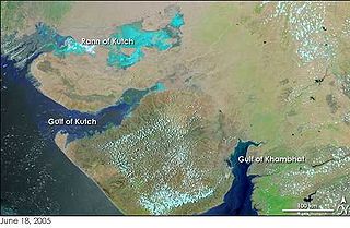
WThe Great Rann of Kutch is a salt marsh in the Thar Desert in the Kutch District of Gujarat, India. It is about 7500 km2 in the area and is reputed to be one of the largest salt deserts in the world. This area has been inhabited by the Kutchi people.
 W
WThe Inner Niger Delta, also known as the Macina or Masina, is the inland delta of the Niger River. It is an area of fluvial wetlands, lakes and floodplains in the semi-arid Sahel area of central Mali, just south of the Sahara desert.
 W
WBangweulu — 'where the water sky meets the sky' — is one of the world's great wetland systems, comprising Lake Bangweulu, the Bangweulu Swamps and the Bangweulu Flats or floodplain. Situated in the upper Congo River basin in Zambia, the Bangweulu system covers an almost completely flat area roughly the size of Connecticut or East Anglia, at an elevation of 1,140 m straddling Zambia's Luapula Province and Northern Province. It is crucial to the economy and biodiversity of northern Zambia, and to the birdlife of a much larger region, and faces environmental stress and conservation issues.
 W
WThe Lake Chad flooded savanna is a flooded grasslands and savannas ecoregion in Africa. It includes the seasonally- and permanently-flooded grasslands and savannas in the basin of Lake Chad in Central Africa, and covers portions of Cameroon, Chad, Niger, and Nigeria.
 W
WThe Little Rann of Kutch is a salt marsh which is part of the Rann of Kutch in Kutch district, Gujarat, India.
 W
WThe Venezuelan Llanos also simply known as Los Llanos in Venezuela, is a large central depression very flat in a vast natural region of approximately 243,774 km2 of extension, equivalent to 26.6% of the total continental territory of the country.
 W
WLukanga Swamp is a major wetland in the Central Province of Zambia, about 50 km west of Kabwe. Its permanently swampy area consists of a roughly circular area with a diameter of 40 to 50 km covering 1850 km2, plus roughly 250 km2 in the mouths of and along rivers discharging into it such as the Lukanga River from the north-east, plus another 500 km2 either side of the Kafue River to the west and north-west, making 2600 km2 in total. It contains many lagoons such as Lake Chiposhye and Lake Suye but few large channels, and its average depth is only 1.5 m.
 W
WThe Makgadikgadi Pan, a salt pan situated in the middle of the dry savanna of north-eastern Botswana, is one of the largest salt flats in the world. The pan is all that remains of the formerly enormous Lake Makgadikgadi, which once covered an area larger than Switzerland, but dried up tens of thousands of years ago. Recent studies of human mitochondrial DNA suggest that modern Homo sapiens first began to evolve in this region some 200,000 years ago, when it was a vast, exceptionally fertile area of lakes, rivers, marshes, woodlands and grasslands especially favorable for habitation by evolving hominins and other mammals.
 W
WThe Mesopotamian Marshes, also known as the Iraqi Marshes, are a wetland area located in Southern Iraq and Southwestern Iran. Historically the marshlands, mainly composed of the separate but adjacent Central, Hawizeh and Hammar Marshes, used to be the largest wetland ecosystem of Western Eurasia. It is a rare aquatic landscape in the desert, providing habitat for the Marsh Arabs and important populations of wildlife. Draining of portions of the marshes began in the 1950s and continued through the 1970s to reclaim land for agriculture and oil exploration. However, in the late 1980s and 1990s, during the presidency of Saddam Hussein, this work was expanded and accelerated to evict Shia Muslims from the marshes. Before 2003, the marshes were drained to 10% of their original size. After the fall of Hussein's regime in 2003, the marshes have partially recovered but drought along with upstream dam construction and operation in Turkey, Syria and Iran have hindered the process. Since 2016 the Mesopotamian marshes have been listed as an UNESCO Heritage Site.
 W
WThe Nenjiang River grassland ecoregion covers the low wetlands of the lower Nen River in northeast China. The region is known for supporting migratory and permanent nesting populations of a variety of migratory waterfowl, including six species of crane.
 W
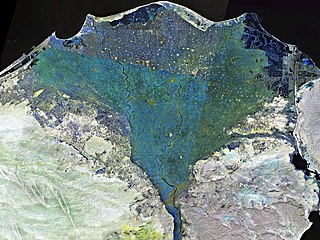
WThe Nile Delta is the delta formed in Lower Egypt where the Nile River spreads out and drains into the Mediterranean Sea. It is one of the world's largest river deltas—from Alexandria in the west to Port Said in the east, it covers 240 km (150 mi) of Mediterranean coastline and is a rich agricultural region. From north to south the delta is approximately 160 km (99 mi) in length. The Delta begins slightly down-river from Cairo.
 W
WThe Nile Delta flooded savanna ecoregion covers both the Nile Delta proper, where the Nile River enters the Mediterranean Sea, as well as the river floodplains of the Nile 1,100 kilometres (680 mi) up-river to the Aswan Dam. Since the Aswan Dam was completed in the 1970s, the Nile on this stretch has not been subject to annual flooding, leading the loss of much of the papyrus sedge swamps and other marshes along the river.
 W
WThe Okefenokee National Wildlife Refuge is a 402,000‑acre (1,627 km2) National Wildlife Refuge located in Charlton, Ware, and Clinch Counties of Georgia, and Baker County in Florida, United States. The refuge is administered from offices in Folkston, Georgia. The refuge was established in 1937 to protect a majority of the 438,000 acre (1,772 km2) Okefenokee Swamp. The name "Okefenokee" is a Native American word meaning "trembling earth."
 W
WThe Okefenokee Swamp is a shallow, 438,000-acre (177,000 ha), peat-filled wetland straddling the Georgia–Florida line in the United States. A majority of the swamp is protected by the Okefenokee National Wildlife Refuge and the Okefenokee Wilderness. The Okefenokee Swamp is considered to be one of the Seven Natural Wonders of Georgia. The Okefenokee is the largest "blackwater" swamp in North America.
WThe Pantanal is a natural region encompassing the world's largest tropical wetland area, and the world's largest flooded grasslands. It is located mostly within the Brazilian state of Mato Grosso do Sul, but it extends into Mato Grosso and portions of Bolivia and Paraguay. It sprawls over an area estimated at between 140,000 and 195,000 square kilometres. Various subregional ecosystems exist, each with distinct hydrological, geological and ecological characteristics; up to 12 of them have been defined.
 W
WThe Paraná flooded savanna (NT0908) is an ecoregion that borders the southern Paraná River in Argentina. It has largely been converted to agriculture or occupied by urban development, but scattered patches of the original habitat remain along the river.
 W
WThe Rann of Kutch is a large area of salt marshes that span the border between Pakistan and India. It is located mostly in Gujarat, India and in some parts of Sindh, Pakistan. It is divided into the Great Rann and Little Rann.
 W
WThe Saharan halophytics ecoregion covers a series of low-lying evaporite depressions and wetlands spread across North Africa. The depressions are characteristically saline, variously chotts or sabkhas. The plants of the areas are highly specialized to survive in the harsh environment, with many being xerophytess (drought-tolerant) and halophytes (salt-tolerant). The biodiversity of the areas has been relatively protected by their isolation, and unsuitability of alkaline soil for farming.
 W
WThe Southern Cone Mesopotamian savanna, also known as the Argentine Mesopotamian grasslands, is a flooded grassland ecoregion of Argentina.
 W
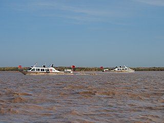
WThe Sudd is a vast swamp in South Sudan, formed by the White Nile's Baḥr al-Jabal section. The Arabic word sudd is derived from sadd (سد), meaning "barrier" or "obstruction". The term "the sudd" has come to refer to any large solid floating vegetation island or mat. The area which the swamp covers is one of the world's largest wetlands and the largest freshwater wetland in the Nile basin.
 W
WThe Suiphun-Khanka meadows and forest meadows ecoregion is a relatively small ecoregion centered on Lake Khanka, a fresh water lake in the Russian Far East, with a portion in China. The terrain is unforested, flat, and marshy. The area is an important stopover spot for migratory birds, including many vulnerable species. It has an area of 33,929 square kilometres (13,100 sq mi), and is in the Flooded grasslands and savannas biome.
 W
WA swamp is a forested wetland. Swamps are considered to be transition zones because both land and water play a role in creating this environment. Swamps vary in size and are located all around the world. The water of a swamp may be fresh water, brackish water, or seawater. Freshwater swamps form along large rivers or lakes where they are critically dependent upon rainwater and seasonal flooding to maintain natural water level fluctuations. Saltwater swamps are found along tropical and subtropical coastlines. Some swamps have hammocks, or dry-land protrusions, covered by aquatic vegetation, or vegetation that tolerates periodic inundation or soil saturation. The two main types of swamp are "true" or swamp forests and "transitional" or shrub swamps. In the boreal regions of Canada, the word swamp is colloquially used for what is more correctly termed a bog, fen, or muskeg. Some of the world's largest swamps are found along major rivers such as the Amazon, the Mississippi, and the Congo.
 W
WThe Yellow Sea saline meadow ecoregion covers a thin strip of wetlands between the Shandong Peninsula and the mouth of the Yangtze River on the coast of the East China Sea. The plants of the region are adapted to the wet, saline soils transitioning inland to fresh water arriving from the west. The area is an important stop-over on the East Asian–Australasian Flyway. The region is under heavy ecological pressure from human development and agriculture.
 W
WThe Zambezian coastal flooded savanna is a flooded grasslands and savannas ecoregion in Mozambique. It includes the coastal flooded savannas and grasslands in the deltas of the Zambezi, Pungwe, Buzi, and Save rivers.
 W
WThe Zambezian flooded grasslands is an ecoregion of southern and eastern Africa that is rich in wildlife.