 W
WBac Mòr is a Scottish island, one of the Treshnish Isles, sometimes referred to as The Dutchman's Cap in English due to its shape.
 W
WBarra Head, also known as Berneray, is the southernmost islands of the Outer Hebrides in Scotland. Within the Outer Hebrides, it forms part of the Barra Isles archipelago. Originally, Barra Head only referred to the southernmost headland of Berneray but is now a common name for the entire island. The highest point of the island is Sotan, a Marilyn.
 W
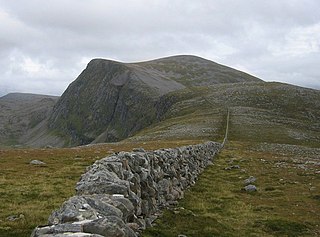
WBeinn Dearg is a mountain in the Inverlael area of the Highlands of Scotland. It is most frequently climbed by following the River Lael up Gleann na Sguaib. Starting from near the head of Loch Broom, a path follows the glen to a bealach, which is about a kilometre north of the summit. From this bealach, the neighbouring peaks of Cona' Mheall and Meall na Ceapraichean may also be climbed. Eididh nan Clach Geala, which lies about 3 km north of Beinn Dearg, is also added in to complete a round of 4 Munros.
 W
WBen Wyvis is a mountain located in Easter Ross, north-west of Dingwall in northern Scotland. It lies in the council area of Highland, and the county of Ross and Cromarty. The mountain is prominent in views of the area, presenting a whale-back shape above the farmland of Strathconon. Geologically, the ridge is composed of Moine pelitic gneiss.
 W
WCaerlaverock is a national nature reserve (NNR) covering parts of the mudflats and shoreline of the Solway Firth about 10 km south of Dumfries, in Dumfries and Galloway, Scotland. It lies between the River Nith and the Lochar Water, and consists of a variety of wetland habitats including bare mud and sand, merse and marshes, and is fringed by neutral grassland on the landward side. A nature reserve was designated in 1957 at the instigation of the Duke of Norfolk. The NNR covers an area of 82 square kilometres (32 sq mi) and is an internationally important wintering site for waterfowl and wading birds.
 W
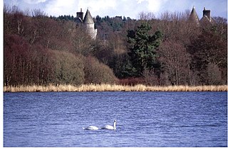
WColl is an island located west of the Isle of Mull in the Inner Hebrides of Scotland. Coll is known for its sandy beaches, which rise to form large sand dunes, for its corncrakes, and for Breacachadh Castle. It is in the council area of Argyll and Bute.
 W
WCoul Links is an area of sand dunes in Sutherland, on the east coast of Scotland. It is located between Golspie and Dornoch, lying just to the north of the small village of Embo. The links are considered unusual within Scotland in displaying a complete transition from the foredune to dune system and coastal heathland. They also include habitats such as flooded slacks and seasonal lochs. The links lie on the eastern side of Loch Fleet, and form part of the Loch Fleet Site of Special Scientific Interest (SSSI), the Dornoch Firth and Loch Fleet Special Protection Area (SPA), and the Dornoch Firth and Loch Fleet Ramsar site, but are outwith the Loch Fleet national nature reserve (NNR). Between 1985 and 2010 the Scottish Wildlife Trust (SWT) managed Coul Links under an agreement with the landowner, however the agreement was not renewed when it expired. The SWT continues to be involved in the management of the adjacent Loch Fleet NNR.
 W
WCreag Meagaidh is a mountain on the northern side of Glen Spean in the Highlands of Scotland. It is a complex mountain, taking the form of a flat summit plateau from which five ridges radiate, and is most famed for the cliffs surrounding the corrie of Coire Ardair on the north-eastern face. These crags are a renowned venue for winter and ice climbing, although being somewhat vegetated they are less suited to summer climbing.
 W
WThe Cromarty Firth is an arm of the Moray Firth in Scotland.
 W
WCuil Bay, meaning recess, corner, niche or nook, is a 237° facing, large sand and shingle coastal embayment with a semi-circular outline, on a chord of 2 km, situated on the south‐west part of the Ardsheal peninsula, on the southern coast of the sea loch of Loch Linnhe, in the parish of Lismore and Appin, within the council area of Lochaber in Scotland. It was formerly part of Argyll and Bute before boundary changes occurred. The bay is situated adjacent to the village of Duror. The bay is reached by a small road that leads from the Duror Primary School, leaving the main A828 road, following the line of the River Duror, as it races to meet the sea, before opening out into a vista of a long shore of meadows and sea-grasses as the land meets the bay proper.
 W
WThe Dornoch Firth is a firth on the east coast of Highland, in northern Scotland. It forms part of the boundary between Ross and Cromarty, to the south, and Sutherland, to the north. The firth is designated as a national scenic area, one of 40 such areas in Scotland. The national scenic area covers 15,782 ha in total, of which 4,240 ha is the marine area of the firth below low tide. A review of the national scenic areas by Scottish Natural Heritage in 2010 commented:By comparison with other east coast firths the Dornoch Firth is narrow and sinuous, yet it exhibits within its compass a surprising variety of landscapes. It is enclosed by abrupt rounded granitic hills clad in heather moor and scree, their Gaelic names of cnoc, meall and creag giving the clue to their character. Their lower slopes are frequently wooded, oakwoods being a noticeable feature of the area, but with other deciduous and coniferous species represented in plantations which vary from the policy plantings of Skibo Castle to the pines of the Struie Forest.
 W
WThe name East Caithness Cliffs refers to weathered sandstone cliffs on the east coast of Caithness in Scotland. The cliffs, which rise to 150 m at Berriedale, provide ideal nesting conditions for breeding seabirds, and are protected by several overlapping conservation designations:The East Caithness Cliffs Special Area of Conservation (SAC) covers the cliffs from the southern boundary of Caithness to just south of Wick, an area of 457 hectares (4.57 km2) in total. The East Caithness Cliffs Nature Conservation Marine Protected Area protects the sea up to 2 km from the SAC, an area of 11,400 hectares (114 km2) in total. The East Caithness Cliffs Special Protection Area (SPA), which covers 11,696 hectares (116.96 km2), includes both the cliffs of the SAC and the seaward area of the MPA.
 W
WFair Isle is an island in Shetland, in northern Scotland. It lies about halfway between mainland Shetland and Orkney. It is known for its bird observatory and a traditional style of knitting. The island has been owned by the National Trust for Scotland since 1954.
WFetlar is one of the North Isles of Shetland, Scotland, with a usually resident population of 61 at the time of the 2011 census. Its main settlement is Houbie on the south coast, home to the Fetlar Interpretive Centre. Fetlar is the fourth-largest island of Shetland and has an area of just over 4,000 hectares (15 sq mi).
 W
WLoch Fleet is a sea loch on the east coast of Scotland, located between Golspie and Dornoch. It forms the estuary of the River Fleet, a small spate river that rises in the hills east of Lairg. The loch was designated a National Nature Reserve (NNR) in 1998, and is managed by a partnership between NatureScot, the Scottish Wildlife Trust (SWT) and Sutherland Estates. The NNR extends to 1058 hectares, including the Loch Fleet tidal basin, sand dunes, shingle ridges and the adjacent pine woods, including Balbair Wood and Ferry Wood. The tidal basin of the loch covers over 630 ha, and forms the largest habitat on the NNR.
 W
WThe Forvie National Nature Reserve is a national nature reserve that is owned and managed by NatureScot. It is located north of Newburgh in Aberdeenshire, in the northeast of Scotland. The reserve includes the Sands of Forvie, which are the fifth largest sand dune system in Britain, and the least disturbed by human activity. The dune system is an integral part of the Ythan Estuary, which also forms part of the reserve, and separates the sands from Balmedie beach.
 W
WHanda Island or simply Handa is an island off the west coast of Sutherland, Scotland. It is 309 hectares and 123 metres (404 ft) at its highest point.
 W
WInsh Marshes are an area of floodplain of the River Spey between Kingussie and Kincraig in Badenoch and Strathspey, Highland, Scotland. The marshes are said to be one of the most important wetlands in Europe. They lie at altitude of approximately 240 to 220 m above sea level, and form one of the largest areas of floodplain mire and fen vegetation in Scotland.
 W
WLoch of Skene is a large lowland, freshwater loch in Aberdeenshire, Scotland. It lies approximately 1 mi (1.6 km) to the west of the village of Kirkton of Skene and 9 mi (14 km) west of Aberdeen.
 W
WThe Loch of Strathbeg is a designated Special Protection Area for wildlife conservation purposes. It is located near to Rattray and Crimond in Aberdeenshire, Scotland.
 W
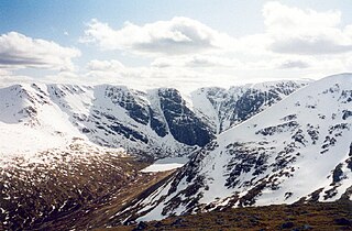
WLochnagar or Beinn Chìochan is a mountain in the Grampians of Scotland, located about five miles south of the River Dee near Balmoral. It is a popular hill with hillwalkers, and is a noted venue for summer and winter climbing.
 W
WThe Lochs of Spiggie and Brow are located west of Boddam in the parish of Dunrossness, in the South Mainland of Shetland, Scotland, about 6 km north of Sumburgh.
 W
WMeikle Loch is an inland loch some miles north of Collieston, Aberdeenshire, Scotland. It is designated as part of the Ythan Estuary complex, along with the Sands of Forvie, as a Special Protection Area for wildlife conservation purposes. Meikle is a Scots word for large/big, which the loch is when compared to the adjacent Little Loch.
 W
WMontrose Basin is a nearly circular tidal basin which makes up part of the estuary of the River South Esk and which sits just inland of the town of Montrose in Angus on the east coast of Scotland. The basin is protected by a number of designations, it is mananged by the Scottish Wildlife Trust as a Wildlife Reserve, as well as being designated as a Local Nature Reserve, Site of Special Scientific Interest,, a Special Protection Area and a Ramsar Site.
WThe Moray Firth is a roughly triangular inlet of the North Sea, north and east of Inverness, which is in the Highland council area of north of Scotland. It is the largest firth in Scotland, stretching from Duncansby Head in the north, in the Highland council area, and Fraserburgh in the east, in the Aberdeenshire council area, to Inverness and the Beauly Firth in the west. Therefore, three council areas have Moray Firth coastline: Highland to the west and north of the Moray Firth and Highland, Moray and Aberdeenshire to the south. The firth has more than 800 kilometres of coastline, much of which is cliff.
 W
WMousa is a small island in Shetland, Scotland, uninhabited since the nineteenth century. The island is known for the Broch of Mousa, an Iron Age round tower, and is designated as a Special Protection Area for storm-petrel breeding colonies.
 W
WThe Rinns of Islay is an area on the west of the island of Islay in the Inner Hebrides of Scotland.
 W
WThe Ythan is a river in the north-east of Scotland rising at Wells of Ythan near the village of Ythanwells and flowing south-eastwards through the towns of Fyvie, Methlick and Ellon before flowing into the North Sea near Newburgh, in Formartine.
WSule Skerry is a remote skerry in the North Atlantic off the north coast of Scotland.
WSule Stack or Stack Skerry is an extremely remote island or stack in the North Atlantic off the north coast of Scotland. It is formed of Lewisian gneiss.
 W
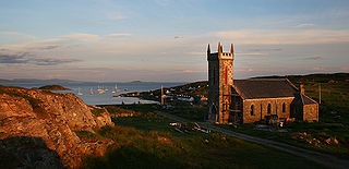
WSumburgh Head is located at the southern tip of the Shetland Mainland in northern Scotland. The head is a 100m high rocky spur capped by the Sumburgh Head Lighthouse. The Old Norse name was Dunrøstar høfdi, it means "The Head onto the loud tide-race", referring to the noise of Sumburgh Roost.
 W
WSwitha is a small uninhabited island towards the south of Orkney, Scotland, approximately 41 hectares in area.
 W
WThe Treshnish Isles is an archipelago of small islands and skerries, lying west of the Isle of Mull, in Scotland. They are part of the Inner Hebrides. Trips to the Treshnish Isles operate from Ulva Ferry, Tobermory and Ardnamurchan in the summer months.
 W
WWestwater Reservoir is an artificial reservoir in the Pentland Hills, Scottish Borders, 3 kilometres (1.9 mi) west of West Linton, and 26 kilometres (16 mi) south west of Edinburgh. It is a drinking water reservoir for Edinburgh and the Lothians and is located 320 metres (1,050 ft) above sea level. It is an important site for wildfowl and is designated as a SSSI and a Ramsar site.
 W
WThe Ythan Estuary is the tidal component of the Ythan River, emptying into the North Sea 19 kilometres (12 mi) north of Aberdeen, Scotland. The estuary’s tidal action extends a 7 kilometres (4.3 mi) inland and has characteristic widths of between 250 metres (820 ft) and 780 metres (2,560 ft). Besides the tidal channel there are interfaces to the upland dunes including mudflats, sand beaches and shingle flats. Reaches of salt marsh occur, but they are primarily near the Waterside Bridge and the mouth of the Tarty Burn, a small tributary river. Based upon the habitat of the moorland bordering the east of the Ythan River near the mouth, this estuary is the most significant coastal moorland in the northern United Kingdom.