 W
WLand use involves the management and modification of natural environment or wilderness into built environment such as settlements and semi-natural habitats such as arable fields, pastures, and managed woods. Land use by humans has a long history, first emerging more than 10 thousand years ago. It also has been defined as "the total of arrangements, activities, and inputs that people undertake in a certain land type."
 W
WA building code is a set of rules that specify the standards for constructed objects such as buildings and nonbuilding structures. Buildings must conform to the code to obtain planning permission, usually from a local council. The main purpose of building codes is to protect public health, safety and general welfare as they relate to the construction and occupancy of buildings and structures. The building code becomes law of a particular jurisdiction when formally enacted by the appropriate governmental or private authority.
 W
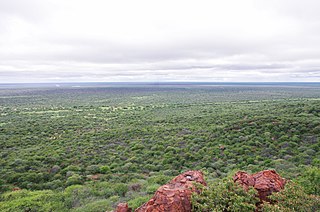
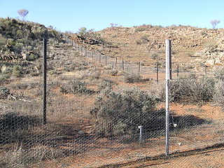
WBush encroachment is a natural phenomenon characterised by the increase in density of woody plants at the expense of the herbaceous layer. It is often considered an ecological regime shift and a symptom of land degradation. Bush encroachment is found to have severe negative consequences on key ecosystem services, especially biodiversity, animal habitat, land productivity and groundwater recharge. Bush encroachment can refer both to the expansion of native plants as well as the invasion and spread of invasive species. The phenomenon is observed across different ecosystems and with different characteristics and intensities globally. Among the more severely affected landscapes is the Veld in Southern Africa.
 W
WThe Conservatoire du littoral is a French public organisation created in 1975 to ensure the protection of outstanding natural areas on the coast, banks of lakes and stretches of water of 10 square kilometres or more. The Conservatoire is a member of the World Conservation Union.
 W
WA fire adapted community is defined by the United States Forest Service as "a knowledgeable and engaged community in which the awareness and actions of residents regarding infrastructure, buildings, landscaping, and the surrounding ecosystem lessens the need for extensive protection actions and enables the community to safely accept fire as a part of the surrounding landscape." The National Wildfire Coordinating Group definition, which was developed and approved by the Wildland Urban Interface Mitigation Committee, is "A human community consisting of informed and prepared citizens collaboratively planning and taking action to safely co-exist with wildland fire."
 W
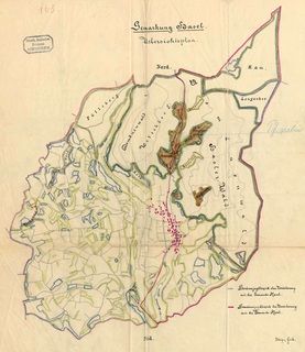
WA Gemarkung is the entirety of all land plots of a specific municipality recorded in the cadastre in the countries of Germany, Austria and Switzerland. Gemarkung registers record the parcels' location, usage and geomorphology and the like qualities, however, the rights to the land are kept in the Grundbuch. A Gemarkung is made up of a number of, usually contiguous, plots of urban (Grundstücke) or rural land (Flurstücke). Between the levels of Flurstück and Gemarkung is often found the level of Flur, usually a tract of open land or forest.
 W
WGrazing is a method of feeding in which a herbivore feeds on low-growing plants such as grasses or other multicellular organisms, such as algae. Many species of animals can be said to be grazers, from large animals such as hippopotamuses to small aquatic snails. Grazing behaviour is a type of feeding strategy within the ecology of a species. Specific grazing strategies include graminivory ; coprophagy ; pseudoruminant ; and grazing on plants other than grass, such as on marine algae.
 W
WThe Havana Plan Piloto was a 1955-1958 urban proposal by Town Planning Associates which included Paul Lester Wiener, Paul Schulz, the Catalan architect Josep Lluis Sert, Seely Stevenson of Value & Knecht, Consulting Engineers seeking to combine "architecture, planning, and law," in a project heavily influenced by the politics of Fulgencio Batista which in turn were dictated by his involvement with the American Mafia and their desire to augment United States tourism, and thru his architects, the modernist principles of CIAM and the Athens Charter. The Charter got its name from the location of the fourth CIAM conference in 1933, which, due to the deteriorating political situation in Russia, took place on the in SS Patris II bound for Athens from Marseilles. This conference is documented in a film commissioned by Sigfried Giedion and made by his friend Laszlo Moholy-Nagy "Architects' Congress." The Charter had a significant impact on urban planning after World War II and, thru Josep Lluis Sert and Paul Lester Wiener, on the proposed modernization of Havana and in the effort erase all vestiges of the 16th-century city.
 W
WHealthy Land and Water Limited is an Australian not-for-profit organisation using evidence-based research and monitoring of South East Queensland waterways to determine catchment health. Queensland Government’s Department of Environment and Science, local councils, water utilities and industry co-fund the organisation to deliver scientific information about the region’s rivers and catchments with the stated aim of guiding on-ground rehabilitation efforts.
 W
WThe Hobrecht-Plan is the binding land-use plan for Berlin in the 19th century. It is named after its main editor, James Hobrecht (1825–1902), who served for the royal Prussian urban planning police ("Baupolizei").
 W
WLand banking is the practice of aggregating parcels of land for future sale or development.
 W
WLand change models (LCMs) describe, project, and explain changes in and the dynamics of land use and land-cover. LCMs are a means of understanding ways that humans change the Earth's surface in the past, present, and future.
 W
WLand consumption as part of human resource consumption is the conversion of land with healthy soil and intact habitats into areas for industrial agriculture, traffic and especially urban human settlements. More formally, the EEA has identified three land consuming activities:The expansion of built-up area which can be directly measured; the absolute extent of land that is subject to exploitation by agriculture, forestry or other economic activities; and the over-intensive exploitation of land that is used for agriculture and forestry.
 W
WLand recycling is the reuse of abandoned, vacant, or underused properties for redevelopment or repurposing.
Wales has a surface area of 20,779 km2 or 2,077,900 ha. It has a border with England to the east, and is bounded by the Irish Sea to the north and west, and by the Bristol Channel to the south. It has an oceanic temperate climate which is markedly influenced by the North Atlantic Current carrying warm water from tropical latitudes. As a result, it has a much milder climate than most places in the world at similar latitudes. Altitudes range from sea-level to 1085 m on the Snowdon Massif.
 W
WThe Laws of the Indies are the entire body of laws issued by the Spanish Crown for the American and the Philippine possessions of its empire. They regulated social, political, religious, and economic life in these areas. The laws are composed of myriad decrees issued over the centuries and the important laws of the 16th century, which attempted to regulate the interactions between the settlers and natives, such as the Laws of Burgos (1512) and the New Laws (1542). Throughout the 400 years of Spanish presence in these parts of the world, the laws were compiled several times, most notably in 1680 under Charles II in the Recopilación de las Leyes de los Reynos de las Indias. This became considered the classic collection of the laws, although later laws superseded parts of it, and other compilations were issued.
 W
WIn land-use planning, a locally unwanted land use (LULU) is a land use that creates externality costs on those living within close proximity. These costs include potential health hazards, poor aesthetics, or reduction in home values. LULUs often gravitate to disadvantaged areas such as slums, industrial neighborhoods and poor, minority, unincorporated or politically under-represented places that cannot fight them off. Such facilities with such hazards need to be created for the greater benefits that they offer society.
 W
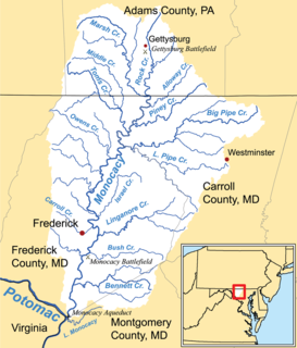
WThe Agricultural Reserve is a designated land use zone in Montgomery County, Maryland. The 93,000 acres (380 km2) zone was created in 1980 by the Montgomery County Council to preserve farm land and rural space in the northwestern part of the county. The farmland protection program has been characterized as "the most famous, most studied and most emulated" program of its kind in the United States.
 W
WA nature reserve, is a protected area of importance for flora, fauna, or features of geological or other special interest, which is reserved and managed for purposes of conservation and to provide special opportunities for study or research. They may be designated by government institutions in some countries, or by private landowners, such as charities and research institutions. Nature reserves fall into different IUCN categories depending on the level of protection afforded by local laws. Normally it is more strictly protected than a nature park. Various jurisdictions may use other terminology, such as ecological protection area or private protected area in legislation and in official titles of the reserves.
 W
WOvergrazing occurs when plants are exposed to intensive grazing for extended periods of time, or without sufficient recovery periods. It can be caused by either livestock in poorly managed agricultural applications, game reserves, or nature reserves. It can also be caused by immobile, travel restricted populations of native or non-native wild animals. However, "overgrazing" is a controversial concept, based on equilibrium system theory. A strong indicator of overgrazing is where additional feed needs to be brought in from outside the farm, often to support livestock through the winter. Traditionally this feed was sourced on the farm, with fewer animals being kept and some fields being used for hay and silage production. Modern farm businesses often choose to keep more animals than their land can support alone; buying in external feed to offset this.
 W
WPrince Mohammad Bin Salman Nature Reserve located between NEOM Project and Red Sea Project northwest Saudi Arabia. It is one of the six royal reserves which were established by royal order in June 2018. It is managed by a legal identity and financial and administrative autonomy under the chairmanship of Crown Prince Mohammed Bin Salman.
 W
WPrivately owned public space (POPS), or alternatively, privately owned public open spaces (POPOS), are terms used to describe a type of public space that, although privately owned, is legally required to be open to the public under a city's zoning ordinance or other land-use law. The acronym POPOS is preferentially used over POPS on the west coast of the US. Both terms can be used to represent either a singular or plural space or spaces. These spaces are usually the product of a deal between cities and private real estate developers in which cities grant valuable zoning concessions and developers provide in return privately owned public spaces in or near their buildings. Privately owned public spaces commonly include plazas, arcades, small parks, and atriums. Many cities worldwide, including Auckland, New York City, San Francisco, Seattle, Seoul, and Toronto, have privately owned public spaces. Some cities and advocacy groups have created websites about these spaces.
 W
WProtected areas or conservation areas are locations which receive protection because of their recognized natural, ecological or cultural values. There are several kinds of protected areas, which vary by level of protection depending on the enabling laws of each country or the regulations of the international organizations involved. Generally speaking though, protected areas are understood to be those in which human presence or at least the exploitation of natural resources is limited.
 W
WRegisters of Scotland (RoS) is the non-ministerial department of the Scottish Government responsible for compiling and maintaining records relating to property and other legal documents. They currently maintain 20 public registers. The official responsible with maintaining the Registers of Scotland is the Keeper of the Registers of Scotland. By ex officio, the Keeper of the Registers of Scotland is also the Deputy Keeper of the Great Seal of Scotland. The Keeper of the Registers of Scotland should not be confused with the Keeper of the Records of Scotland.
 W
WThe Sacred Headwaters is a large subalpine drainage basin centred around Klappan Mountain of the Klappan Range in northern British Columbia. It is the source of three wild salmon rivers: the Skeena River, Nass River, and Stikine River. It is also referred to as the Klappan Valley, although the Klappan—a tributary of the Stikine River—is only one of the area's watersheds. Local Tahltan people call the area Klabona, which is loosely translated as "headwaters."
 W
WThe Scottish Land Commission was established by the Scottish Government following the passage of the Land Reform (Scotland) Act 2016 by the Scottish Parliament; the Commission also incorporates the work of the Tenant Farming Commissioner. The Lands Commissioners, who constitute the Commission, have functions relating to land in Scotland, so that they address issues which relate to ownership of land, land rights, management of land, and use of land. The Tenant Farming Commissioner has the aim of improving the relationship between tenant farmers and land owners, and can create codes of practice, provide practical guidance, and must consult on such matters. The Tenant Farming Commissioner cannot be an agricultural landlord or agricultural tenant, and will develop codes of practice which are in addition to the law and the jurisdiction of the Scottish Land Court.
 W
WA seascape is a photograph, painting, or other work of art which depicts the sea, in other words an example of marine art. The word originated as a formation from landscape, which was first used of images of land in art. By a similar development, "seascape" has also come to mean actual views of the sea itself, and to be applied in planning contexts to geographical locations possessing a good view of the sea.
 W
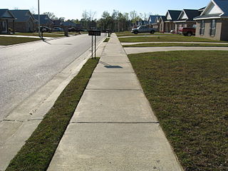
WSubdivision is the act of dividing land into pieces that are easier to sell or otherwise develop, usually via a plat. The former single piece as a whole is then known in the United States as a subdivision. Subdivisions may be simple, involving only a single seller and buyer, or complex, involving large tracts of land divided into many smaller parcels. If it is used for housing it is typically known as a housing subdivision or housing development, although some developers tend to call these areas communities.
 W
WSurveying or land surveying is the technique, profession, art, and science of determining the terrestrial or three-dimensional positions of points and the distances and angles between them. A land surveying professional is called a land surveyor. These points are usually on the surface of the Earth, and they are often used to establish maps and boundaries for ownership, locations, such as the designed positions of structural components for construction or the surface location of subsurface features, or other purposes required by government or civil law, such as property sales.
 W
WTenmile Creek is a tributary stream of Little Seneca Creek in Montgomery County, Maryland.
 W
WThe tragedy of the commons describes a situation in economic science when individual users, who have open access to a resource unhampered by shared social structures or formal rules that govern access and use, act independently according to their own self-interest and, contrary to the common good of all users, cause depletion of the resource through their uncoordinated action. The concept originated in an essay written in 1833 by the British economist William Forster Lloyd, who used a hypothetical example of the effects of unregulated grazing on common land in Great Britain and Ireland. The concept became widely known as the "tragedy of the commons" over a century later after an article written by Garrett Hardin in 1968.
The Transportation and Land Use Coalition (TALC) is a non-profit organization which serves as a partnership of over 100 organizations in the San Francisco Bay Area focused on smart growth, public transportation, environmental causes, and other issues connected with transit and urban planning. TALC was founded in 1997, and is based in Oakland, California. A year after its founding, TALC's involvement in public-transportation advocacy was cited as part of a shift toward public support for increasing funding for buses, trains, and bike paths.
 W
WTsilhqot'in Nation v British Columbia is a landmark decision of the Supreme Court of Canada that established Aboriginal land title for the Tsilhqot'in First Nation, with larger effects. As a result of the landmark decision, provinces cannot unilaterally claim a right to engage in clearcut logging on lands protected by Aboriginal title; they must engage in meaningful consultation with the title holder before they proceed. Although the Aboriginal title holder does not have to consent to the activity, meaningful consultation is required before infringement of the right can take place.
 W
WA proposed Union Mills Reservoir represents a half century of efforts by the Commissioners of the Carroll County, Maryland, to build variations on a "dam" or "reservoir" near Union Mills, Maryland, on the Big Pipe Creek, defeated by a petition led by the Carroll County Taxpayers' Committee in the 1970s. The plan may be alive among some county officials but may also be postponed "indefinitely." Land threatened by the reservoir includes the Whittaker Chambers Farm, also known as the Pipe Creek Farm, a National Historic Landmark as well as protected under the Maryland Agricultural Land Preservation Foundation (MALPF).
 W
WUrbanization refers to the population shift from rural to urban areas, the decrease in the proportion of people living in rural areas, and the ways in which societies adapt to this change. It is predominantly the process by which towns and cities are formed and become larger as more people begin living and working in central areas.
 W
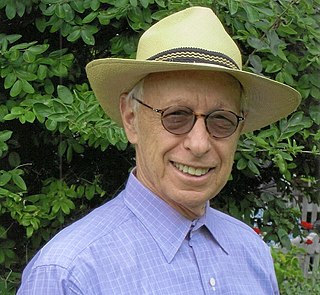
WPeter M. Wolf is an American author, land planning and urban policy authority, investment manager, and philanthropist. He lives in New York City.