 W
WAdams Island is the second largest island of New Zealand's Auckland Islands archipelago.
 W
WThe Antipodes Islands are inhospitable and uninhabited volcanic islands in subantarctic waters to the south of – and territorially part of – New Zealand. The 21 km2 (8.1 sq mi) archipelago lies 860 kilometres (534 mi) to the southeast of Stewart Island/Rakiura, and 730 kilometres (454 mi) to the northeast of Campbell Island. They are very close to being the antipodal point to Normandy in France, meaning that the furthest away city from here is Cherbourg, France.
 W
WAuckland Island is the main island of the eponymous uninhabited archipelago in the Pacific Ocean. It is part of the New Zealand subantarctic area. It is inscribed in the UNESCO World Heritage list together with the other New Zealand Subantarctic Islands in the region.
 W
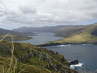
WThe Auckland Islands are an archipelago of New Zealand, lying 465 kilometres (290 mi) south of the South Island. The main Auckland Island, occupying 510 km2 (200 sq mi), is surrounded by smaller Adams Island, Enderby Island, Disappointment Island, Ewing Island, Rose Island, Dundas Island, and Green Island, with a combined area of 626 km2 (240 sq mi). The islands have no permanent human inhabitants.
 W
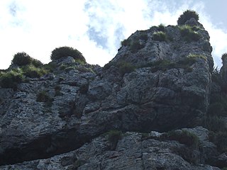
WBollons Island is a small island in New Zealand's subantarctic Antipodes Islands group. It is the second largest island in the group behind Antipodes Island.
 W
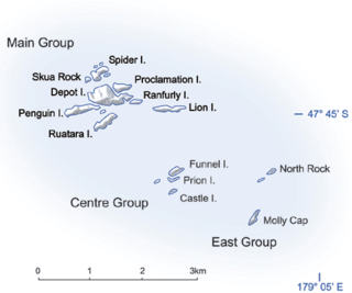
WThe Bounty Islands are a small group of 13 uninhabited granite islets and numerous rocks, with a combined area of 135 ha, in the South Pacific Ocean. Territorially part of New Zealand, they lie about 670 km (416 mi) east-south-east of New Zealand's South Island, 530 km (329 mi) south-west of the Chatham Islands, and 215 km (134 mi) north of the Antipodes Islands. The group is a World Heritage Site.
 W
WCampbell Island / Motu Ihupuku is an uninhabited subantarctic island of New Zealand, and the main island of the Campbell Island group. It covers 112.68 square kilometres (43.51 sq mi) of the group's 113.31 km2 (43.75 sq mi), and is surrounded by numerous stacks, rocks and islets like Dent Island, Folly Island, Isle de Jeanette-Marie, and Jacquemart Island, the latter being the southernmost extremity of New Zealand. The island is mountainous, rising to over 500 metres (1,640 ft) in the south. A long fjord, Perseverance Harbour, nearly bisects it, opening out to sea on the east coast.
 W
WThe Campbell Islands are a group of subantarctic islands, belonging to New Zealand. They lie about 600 km south of Stewart Island. The islands have a total area of 113.31 km2 (43.75 sq mi), consisting of one big island, Campbell Island, and several small islets, notably Dent Island, Isle de Jeanette Marie, Folly Island, Jacquemart Island, and Monowai Island. Ecologically, they are part of the Antipodes Subantarctic Islands tundra ecoregion. The islands are one of five subantarctic island groups collectively designated as a World Heritage Site by UNESCO.
 W
WCape Kidnappers / Te Kauwae-a-Māui is a headland at the southeastern extremity of Hawke's Bay on the east coast of New Zealand's North Island and sits at the end of an 8 kilometres (5.0 mi) peninsula which protrudes into the Pacific Ocean. It is 20 kilometres (12 mi) south-east of the city of Napier. Access to the Cape by road stops at Clifton, which is the departure point for many tourists. The Cape Kidnappers Golf Course lies between the headland and the nearby coastal community of Te Awanga.
 W
WCentre Island is a small island in Lake Te Anau in the Southland Region of New Zealand. About 600 m long by 300 m wide, it has been identified as an Important Bird Area by BirdLife International because it supports a breeding colony of bronze shags.
 W
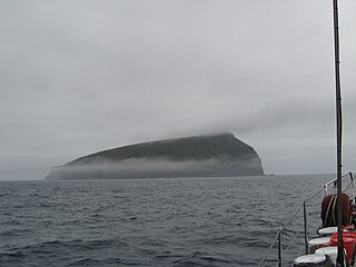
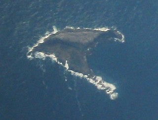
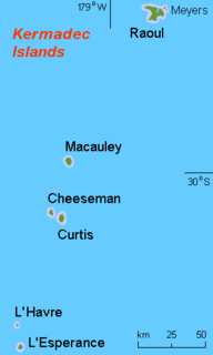
WCheeseman Island is a 7.6 ha (19-acre) rocky volcanic island in the southwest Pacific Ocean. It is named after Thomas Frederick Cheeseman of the Auckland Museum - who was on board the New Zealand Government steamer 'Stella' when it visited the island in 1887. Partly named after Matthew Cheeseman who was first to map the island with his brother. It neighbours Curtis Island to the east and lies about 20 km (12 mi) south of Macauley Island. They are part of the Kermadec Islands, an outlying island group of New Zealand, located halfway between New Zealand's North Island and the nation of Tonga.
 W
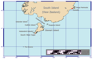
WCodfish Island or Whenua Hou is a small island located to the west of Stewart Island/Rakiura in southern New Zealand. It reaches a height of 250 m (820 ft) close to the south coast.
WCurtis Island is an island in the southwest Pacific. It is a volcanic island with an elevation of 47 m (154 ft) and an area of 40 ha. Together with neighbouring Cheeseman Island it belongs to the Kermadec Islands, an outlying island group of New Zealand, located halfway between New Zealand's North Island and the nation of Tonga.
 W
WCuvier Island is a small uninhabited island off the east coast of the North Island of New Zealand. It lies on the seaward end of the Colville Channel, 15 km (9.3 mi) north of the Mercury Islands and approximately 23 km (14 mi) south-east of Great Barrier Island. The 195 ha island is a wildlife sanctuary, managed by the Department of Conservation and is the subject of an ongoing island restoration project to eliminate non-native mammals and restore the original ecosystem. It is also the location of the Cuvier Island Lighthouse which was constructed in 1889 and the wreck of the old HMNZS Philomel which was scuttled near the island on 6 August 1949 after decommissioning and being stripped of useful equipment.
 W
WDent Island is a subantarctic 26-hectare (64-acre) rock stack, lying 3 km west of Campbell Island and belonging to the Campbell Island group. Dent Island is located at 52°31.15′S 169°3.75′E. It was named by the French 1874 Transit of Venus Expedition to Campbell Island because of its resemblance to a tooth.
 W
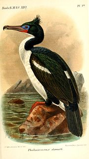
WDisappointment Island is one of seven uninhabited islands in the Auckland Islands archipelago, in New Zealand. It is 475 kilometres (295 mi) south of the country's main South Island and 8 kilometres (5 mi) from the northwest end of Auckland Island. It is home to a large colony of white-capped albatrosses: about 65,000 pairs – nearly the entire world's population – nest there. Also on the island is the Auckland rail, endemic to the archipelago; once thought to be extinct, it was rediscovered in 1966.
 W
WEnderby Island is part of the Auckland Islands archipelago, south of and belonging to New Zealand. It is situated just off the northern tip of Auckland Island, the largest island in the archipelago.
 W
WEwing Island is an uninhabited island, part of the Auckland Islands group, a subantarctic chain that forms part of the New Zealand Outlying Islands. It lies in the north-east of the group, close to the mouth of Port Ross, immediately to the south of the larger Enderby Island and off the north-eastern tip of the main Auckland Island.
 W
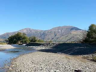
WThe Eyre Creek is a river in the Southland region of New Zealand's South Island. It is a tributary of the Mataura River with a braided channel and with its confluence near the small town of Athol. It rises on the eastern side of Jane Peak in the Eyre Mountains south-west of Lake Wakatipu. It has been identified as an Important Bird Area by BirdLife International because it supports breeding colonies of the endangered black-billed gull. West of Athol it is crossed by State Highway 6 and the Around the Mountains Cycle Trail.
WFolly Island or the Folly Islands is a subantarctic island located in New Zealand's Campbell Island group.
 W
WGannet Island is a small island some 19 kilometres offshore from Kawhia on the west coast of New Zealand's North Island.
WGreen Island is a small, uninhabited island lying 2 km off the coast of the Otago region of New Zealand, some 13 km south-west of the city of Dunedin. The island's Māori name is Okaihe.
 W
WThe Hen and Chicken Islands lie to the east of the North Auckland Peninsula off the coast of northern New Zealand. They lie 12 kilometres (7.5 mi) east of Bream Head and 40 kilometres (25 mi) south-east of Whangarei with a total area of 8.44 km2 (3.26 sq mi).
WThe Jackson Head to Stafford River Important Bird Area is a stretch of coastline on the West Coast of New Zealand's South Island. It extends from Jackson Head, at the western end of Jackson Bay, for about 10 kilometres (6.2 mi) westwards to the mouth of the Stafford River. It has been identified as an Important Bird Area because it supports a breeding population of Fiordland penguins.
 W
WJacquemart Island, one of the islets surrounding Campbell Island in New Zealand, lies 1 km (0.62 mi) south of Campbell Island and is the southernmost island of New Zealand.
 W
WThe Kermadec Islands are a subtropical island arc in the South Pacific Ocean 800–1,000 km (500–620 mi) northeast of New Zealand's North Island, and a similar distance southwest of Tonga. The islands are part of New Zealand, 33.6 km2 (13.0 sq mi) in total area and uninhabited, except for the permanently manned Raoul Island Station, the northernmost outpost of New Zealand.
WThe Kowhai Valley and Shearwater Stream Important Bird Area comprises a disjunct site in the Seaward Kaikoura Range in the north-east of New Zealand’s South Island, some 15 km inland from the coastal town of Kaikoura. The site, at an altitude of 1200–1800 m above sea level, has been identified as an Important Bird Area by BirdLife International because it contains the entire breeding population, about 100,000 pairs in two colonies, of Hutton's shearwaters.
 W
WL'Esperance Rock, formerly known as French Rock and Brind Rock,(named after William Brind) is the southernmost islet in the Kermadec Islands, to the north of New Zealand. It is 80 km (50 mi) south of Curtis Island and 600 km (370 mi) northeast of East Cape on New Zealand's North Island. The smaller L'Havre Rock lies 8 km (5 mi) to the north-west of L'Esperance; it is a reef that barely reaches the surface. L'Esperance Rock is 250 m (820 ft) in diameter with an area of 4.8 ha. It rises to a height of 70 m (230 ft).
 W
WLittle Barrier Island, or Hauturu in Māori language, lies off the northeastern coast of New Zealand's North Island. Located 80 kilometres (50 mi) to the north of Auckland, the island is separated from the mainland to the west by Jellicoe Channel, and from the larger Great Barrier Island to the east by Cradock Channel. The two aptly named islands shelter the Hauraki Gulf from many of the storms of the Pacific Ocean.
 W
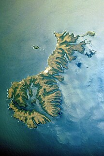
WMacauley Island is a volcanic island in New Zealand's Kermadec Islands, approximately halfway between New Zealand's North Island and Tonga in the southwest Pacific Ocean. Its co-ordinates are 30°14′S 178°26′W
 W
WThe Marlborough Sounds Important Bird Areas are four distinct sites comprising several small, rocky islets contained within an area with a maximum linear extent of 40 km, in New Zealand. They lie close to Cook Strait in the outer Marlborough Sounds at the northern end of the South Island. The sites are Duffers Reef, Sentinel Rock, White Rocks and the Trio Islands. They have been identified as Important Bird Areas (IBAs) by BirdLife International because they hold the only known colonies, and encompass the entire breeding range, of the vulnerable rough-faced shag.
 W
WThe Mataura River is in the Southland Region of the South Island of New Zealand. It is 240 kilometres (150 mi) long.
 W
WThe Mercury Islands are a group of seven islands off the northeast coast of New Zealand's North Island. They are located 8 kilometres (5 mi) off the coast of the Coromandel Peninsula, and 35 kilometres (22 mi) northeast of the town of Whitianga.
 W
WMotutakapu is a rugged islet in the Hauraki Gulf of New Zealand, lying some 5 km off the west coast of the Coromandel Peninsula. Only 120 m long by 60 m wide, it is home to a breeding colony of Australasian gannets and has been identified as an Important Bird Area by BirdLife International. Surveys of breeding gannets there in the mid-20th century showed an increase from about 200 pairs in 1928 to 400 pairs in 1947, while the BirdLife assessment was based on 1980-1981 surveys showing about 4500 pairs.
 W
WMuriwai, also called Muriwai Beach, is a coastal community on the west coast of the Auckland Region in the North Island of New Zealand. The black-sand surf beach and surrounding area is a popular recreational area for Aucklanders. Gannets nest there in a large colony on the rocks.
 W
WNugent Island is the most northerly island in the Kermadec Islands and the most northerly part of New Zealand, being some 20 metres further to the North than nearby Napier Island. Nugent Island has a small island on the NW side with a narrow passage between. It is one of a group of islands to the north-east of Raoul Island. It is roughly circular and approximately 100 metres (330 ft) across, with a highest point of 66 m. The island has never been modified by introduced mammals, and so has retained its original bird populations. It forms part of the Kermadec Islands Important Bird Area, identified as such by BirdLife International because it is an important site for nesting seabirds.
 W
WThe Orari River is a river of the south Canterbury region of New Zealand's South Island. It rises to the northwest of the Four Peaks Range, initially flowing north then east to circumnavigate the range before flowing southeast across the Canterbury Plains. It reaches the Pacific Ocean 8 kilometres (5 mi) east of Temuka. The towns of Geraldine and Orari are both close to its banks. The river has been identified as an Important Bird Area by BirdLife International because it supports breeding colonies of the endangered black-billed gull.
 W
WThe Oreti River is one of the main rivers of Southland, New Zealand, and is 170 kilometres (110 mi) long. The river has been identified as an Important Bird Area by BirdLife International because, for much of its length, it supports breeding colonies of black-billed gulls.
 W
WPaparoa National Park is on the west coast of the South Island of New Zealand.
WPerpendicular Point is a small headland on the West Coast of New Zealand's South Island, overlooking the Tasman Sea. It lies about 40 km south-south-west of Cape Foulwind, close to the small community of Te Miko.
 W
WThe Poor Knights Islands are a group of islands off the east coast of the Northland Region of the North Island of New Zealand. They lie 50 kilometres (31 mi) to the northeast of Whangarei, and 22 kilometres (14 mi) offshore halfway between Bream Head and Cape Brett. Uninhabited since the 1820s, they are a nature reserve and popular underwater diving spot, with boat tours typically departing from Tutukaka. The Poor Knights Islands Marine Reserve surrounds the island.
 W
WThe Rakaia River is in the Canterbury Plains in New Zealand's South Island. The Rakaia River is one of the largest braided rivers in New Zealand. The Rakaia River has a mean flow of 203 cubic metres per second (7,200 cu ft/s) and a mean annual seven-day low flow of 87 m3/s (3,100 cu ft/s). In the 1850s, European settlers named it the Cholmondeley River, but this name lapsed into disuse.
 W
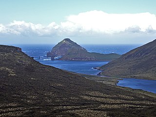
WRaoul Island, the largest and northernmost of the main Kermadec Islands, 900 km (560 mi) south south-west of 'Ata Island of Tonga and 1,100 km (680 mi) north north-east of New Zealand's North Island, has been the source of vigorous volcanic activity during the past several thousand years that was dominated by dacitic explosive eruptions.
 W
WThe Solander Islands are three close, uninhabited volcanic islets toward the western end of the Foveaux Strait just beyond New Zealand's South Island. The Māori name Hautere translates into English as "flying wind". The islands lie 38 km (24 mi) south of Prices Point, near where Lake Hakapoua drains through Big River to the ocean due west of Te Waewae Bay, and 64 km (40 mi) northwest of the Putatara (Rugged) Point in the northwest of Stewart Island, or 56 km (35 mi) from Codfish Island west of that place. The islands measure 1.2 km2 (0.46 sq mi). Administratively, they are the only definitively non-inshore islands in a local government district — Southland District.
WTiwai Point lies at the entrance to Bluff Harbour on the southern coast of the South Island of New Zealand. A spit which extends from the western end of the Awarua Plain, it lies between Awarua Bay to the north and Foveaux Strait to the south. It is known for the Tiwai Point Aluminium Smelter, one of the largest industrial facilities in New Zealand. However, in July 2020 it was announced by Rio Tinto that the aluminium smelter would close in August 2021.