 W
WAmistad Reservoir is a reservoir on the Rio Grande at its confluence with the Devils River 12 miles (19 km) northwest of Del Rio, Texas. The lake is bounded by Val Verde County on the United States side of the international border and by the state of Coahuila on the Mexican side of the border; the American shoreline forms the Amistad National Recreation Area. The reservoir was formed in 1969 by the construction of Amistad Dam. The dam and lake are managed jointly by the governments of the United States and Mexico through the International Boundary and Water Commission. The name of the dam and lake is the Spanish word for "friendship". The reservoir is also known as Lake Amistad.
 W
WCerro El Potosí is the highest mountain in the Sierra Madre Oriental mountain range of northeast Mexico. It is located in the state of Nuevo León, about 80 km (50 mi) south of Monterrey.
 W
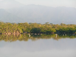
WThe Chamela-Cuixmala Biosphere Reserve is a nature reserve on the Pacific coast of the Mexican state of Jalisco. The park was founded in 1993 and covers 131.42 square kilometres in La Huerta Municipality. The land is mountainous and contains dry tropical forest and rolling hills and alluvial plains.
 W
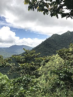
WThe Chimalapas montane forests is a tropical moist broadleaf forest ecoregion in southern Mexico. It includes the montane tropical forests of the Chimalapas region on the boundary of Chiapas and Oaxaca.
 W
WThe Ciénegas del Lerma is a wetland in central Mexico. It consists of three lakes in the Toluca Valley, the upper basin of the Lerma River, near the city of Toluca. The wetlands cover 3,023 hectares.
 W
WThe Colorado River Delta is the region where the Colorado River flows into the Gulf of California in eastern Mexicali Municipality in the north of the state of Baja California in northwesternmost Mexico. The delta is part of a larger geologic region called the Salton Trough. Historically, the interaction of the river's flow and the ocean's tide created a dynamic environment, supporting freshwater, brackish, and saltwater species. Within the delta region, the river split into multiple braided channels and formed a complex estuary and terrestrial ecosystems. The use of water upstream and the accompanying reduction of freshwater flow has resulted in the loss of most of the wetlands of the area, as well as drastic changes to the aquatic ecosystems. However, a scheme is currently in place which aims to rejuvenate the wetlands by releasing a pulse of water down the river delta.
 W
WCuatro Ciénegas is a city in the northern Mexican state of Coahuila. It stands at 26°59′N 102°03′W, at an average elevation of 740 metres (2,430 ft) above sea level. The city serves as the municipal seat for the surrounding municipality of the same name.
 W
WEl Triunfo Biosphere Reserve is a biosphere reserve in southern Mexico. It is in the Sierra Madre de Chiapas in southern Chiapas.
 W
WFalcon International Reservoir, commonly called Falcon Lake, is a reservoir on the Rio Grande 40 miles (64 km) southeast of Laredo, Texas, United States, and Nuevo Laredo, Tamaulipas, Mexico. The huge lake is bounded by Starr and Zapata Counties on the Texas side of the international border and the municipality and city of Nueva Ciudad Guerrero on the Tamaulipas side. The reservoir was formed by the construction of the Falcon Dam to provide water conservation, irrigation, flood control, and hydroelectricity to the area.
WThe Grutas de Cacahuamilpa National Park in Guerrero, Mexico, is best known for the Grutas de Cacahuamilpa Caverns, which are one of the largest cave systems in the world. It is also home to the Grutas of Carlos Pacheco, a smaller system, as well as two subterranean rivers which have carved out tunnels in the rock. The park has outdoor pursuit attractions such as rappelling, and rock climbing in Limontitla Canyon. as well as the two underground rivers to explore. It also has a small botanical garden, a pool and places to camp.
 W
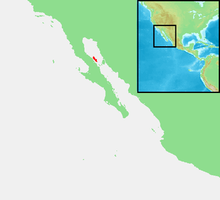
WGuadalupe Island or Isla Guadalupe is a volcanic island located 241 kilometres off the west coast of Mexico's Baja California Peninsula and about 400 km (200 nmi) southwest of the city of Ensenada in the state of Baja California, in the Pacific Ocean. The various volcanoes are extinct or dormant. In 2005 Guadalupe Island and its surrounding waters and islets were declared a biosphere reserve to restore its vegetation and to protect its population of marine mammals and birds. The island is a popular destination for white shark cage diving. Guadalupe Island is inhabited only by scientists, military personnel operating a weather station, and a small group of seasonal fishermen. The island is mostly arid and has very little surface water.
 W
WThe Guadalupe Island Biosphere Reserve,, is located in the Pacific Ocean and is part of Baja California state of Mexico. The Reserve consists of Guadalupe Island and several small islands nearby plus a large expanse of surrounding ocean. The Reserve was created by the government of Mexico on 25 April 2005 and is located 250 kilometres (160 mi) from the mainland. The Reserve is 4,770 square kilometres (1,840 sq mi) in size of which 263 square kilometres (102 sq mi) consists of land and the remainder of water.
 W
WIsla Ángel de la Guarda, also called Archangel Island, is a large island in the Gulf of California east of Bahía de los Ángeles in northwestern Mexico, separated from the Baja California Peninsula by the Canal de Ballenas. It is the second largest of the eleven Midriff Islands or Islas Grandes. It is part of the state of Baja California, located northwest of Tiburón Island. It is a biological reserve called Isla Angel de la Guarda National Park. The island is part of the Mexicali municipality.
 W
WThe Marieta Islands are a group of small uninhabited islands a few miles off the coast of the state of Nayarit, Mexico, located in federal waters approximately 7.9 kilometres (4.9 mi) southwest of the peninsula known as Punta de Mita, in the municipality of Bahía de Banderas.
WThe Janos Biosphere Reserve is a nature reserve in Janos, Chihuahua, Mexico. It protects a prairie ecosystem best known for its recovering and reintroduced species most notably the herd of American bison which became the first re-established in Mexico. It is the first federally protected area of Mexico with the main objective of protecting a grassland ecosystem.
WLa Encrucijada Biosphere Reserve is a UNESCO Biosphere Reserve situated in the Pacific Coastal Lowlands physiographic region of Mexico. It covers 144,848 hectares (559.26 sq mi) stretching over six municipalities in the Costa de Chiapas. It is composed of two large coastal lagoon systems that correspond to two core areas, and a wide variety of natural ecosystems including mangroves, zapotonales, tule swamps and marshes, as well as patches of tropical seasonal forest, coastal dunes and palm trees.
 W
WLa Malinche National Park is located in the states of Puebla and Tlaxcala in Central Mexico. The park is east of Mexico City, and about 44 kilometres (27 mi) from the capital city of Tlaxcala, Tlaxcala.
 W
WLa Michilía Biosphere Reserve is a protected area in northwestern Mexico. It is located in the Sierra Madre Occidental range in southern Durango state.
 W
WLa Sepultura is a biosphere reserve in southern Mexico. It protects a portion of the Sierra Madre de Chiapas range in the state of Chiapas.
 W
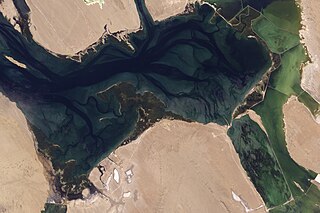
WLaguna de Términos is the largest tidal lagoon by volume located entirely on the Gulf of Mexico, as well as one of the most biodiverse. Exchanging water with several rivers and lagoons, the Laguna is part of the most important hydrographic river basin in Mexico. It is important commercially, as well as ecologically by serving as a refuge for an extensive number of flora and fauna; its mangroves provide an important role as a refuge for migratory birds.
WLaguna Madre is a coastal lagoon in Northeastern Mexico. It extends along the coast of Tamaulipas for over 200 km, from the Río Bravo Delta on the north to the mouth of the Soto la Marina River near La Pesca in the south. Laguna Madre is separated from the Gulf of Mexico on the east by a number of barrier islands, including Barra Los Americanos, Barra Jesús María, and Barra Soto la Marina, and is bounded on the west by the Tamaulipan mainland. It is located in the municipalities of Matamoros, San Fernando, and Soto la Marina.
 W
WLagunas de Montebello, or Montebello Lakes, is a national park in the Mexican state of Chiapas, near the border with Guatemala, comprising 59 multi-colored lakes in a pine forest and two Maya ruins. It was the first national park in Chiapas when created in 1959, and in 2009 the park was designated a Biosphere Reserve by UNESCO.
 W
WLake Chapala is Mexico's largest freshwater lake. It lies in the municipalities of Chapala, Jocotepec, Poncitlán, and Jamay, in Jalisco, and in Venustiano Carranza and Cojumatlán de Régules, in Michoacán.
 W
WLake Cuitzeo is a lake in the central part of Mexico, in the state of Michoacán. It has an area of 300–400 km2 (120–150 sq mi). The lake is astatic, meaning the volume and level of water in the lake fluctuates frequently. It is the second-largest freshwater lake in Mexico.
 W
WLake Pátzcuaro is a lake in the municipality of Pátzcuaro, Michoacán, Mexico.
WMaderas del Carmen is a biosphere reserve in the northern Mexican state of Coahuila.
 W
WMarismas Nacionales-San Blas mangroves is a mangrove ecoregion of the Pacific coast of Mexico. The marismas nacionales stretches from Mazatlán, Sinaloa southwards to San Blas, Nayarit.
 W
WOjo de Liebre Lagoon, translated into English as "hare eye lagoon", is a coastal lagoon located in Mulegé Municipality near the town of Guerrero Negro in the northwestern Baja California Sur state of Mexico. It lies approximately halfway between the southern tip of the Baja California Peninsula and the U.S.-Mexico border, opening onto the Pacific Ocean.
WOmiltemi Ecological State Park is a protected area in southern Mexico. It is located in the Sierra Madre del Sur of Guerrero. The park includes well-preserved pine–oak forests and cloud forests.
 W
WThe Pantanos de Centla are wooded wetlands along the coast in state of Tabasco in Mexico. They have been protected since 2006 with the establishment of the Pantanos de Centla Biosphere Reserve. It is also a World Wildlife Fund ecoregion.
WPapigochic Flora and Fauna Protection Area is a protected area in Chihuahua state of Mexico. It covers an area of 2227.64 km2 in the eastern Sierra Madre Occidental. To the northwest it adjoins Tutuaca Flora and Fauna Protection Area.
 W
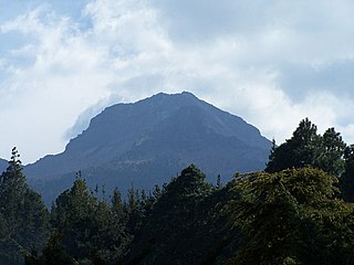
WPico de Tancítaro, also known as Volcán Tancítaro, is a volcanic mountain in Mexico. It is located in Tancítaro municipality in Michoacán state. It is the highest peak in Michoacán.
 W
WThe Revillagigedo Islands or Revillagigedo Archipelago are a group of four volcanic islands in the Pacific Ocean, known for their unique ecosystem. They lie approximately 285 miles (458 km) from Socorro Island south and southwest of Cabo San Lucas, the southern tip of the Baja California Peninsula, and 698 to 1,092 kilometres west of Manzanillo. Historically linked to the Mexican state of Colima, which was granted the islands in 1861 to establish a penal colony, the islands are under Mexican federal property and jurisdiction.
 W
WRía Lagartos Biosphere Reserve is a UNESCO Biosphere Reserve in the state of Yucatán, Mexico. The reserve is located at the eastern end of the coastal strip of the Yucatán Peninsula, with the Gulf of Mexico at its northern limit. The area encompasses coastal areas of the Gulf of Mexico and includes important wetlands designated under the Ramsar Wetlands Convention. The site presents a rich diversity of landscapes and ecosystems, such as mangroves, small estuaries, medium semi-evergreen forest, low deciduous forest, coastal dune vegetation, coastal lagoons, marshes (petenes) and savanna represented by tular vegetation, grasslands and reed beds that are the main nesting sites for marshland and sea birds.
 W
WSan Ignacio Lagoon is a lagoon located in Mulegé Municipality of the Mexican state of Baja California Sur, 59 kilometres (37 mi) from San Ignacio, Mexico and Highway 1. It is one of the winter sanctuaries of the eastern Pacific gray whales.
 W
WScorpion Reef is a reef surrounding a small group of islands in the Gulf of Mexico off the northern coast of the state of Yucatán, Mexico. Designated a national park, the reef is part of the Campeche Bank archipelago and is the largest reef in the southern Gulf of Mexico. It contains five main vegetated islands: Isla Pérez, Isla Desertora, Isla Pájaros, Isla Chica, and Isla Desterrada. Isla Pérez is the only inhabited island and includes a lighthouse. The reef, including its islets and surrounding waters, has been recognised as an Important Bird Area (IBA) by BirdLife International because it supports a population of magnificent frigatebirds.
WSelva El Ocote is a biosphere reserve in Mexico. It includes mid-elevation and highland rain forests and extensive caverns.
 W
WThe Serranía de Zapalinamé, also known as the Sierra de Zapalinamé is a mountain range and protected area of northeastern Mexico. The city of Saltillo lies immediately north of the mountains.
WSian Kaʼan Biosphere Reserve is a biosphere reserve in the municipality of Tulum in the Mexican state of Quintana Roo. It was established in 1986 and became a UNESCO World Heritage Site in 1987.
WThe Sierra de Huautla is a mountain range and biosphere reserve in central Mexico. Located in southern Morelos, the Sierra de Huautla is a southern extension of the Trans-Mexican Volcanic Belt range into the Balsas Basin. The dry forests of Sierra are home to a diverse community of animals and plants, and the reserve's outstanding biodiversity is recognized by UNESCO.
 W
WThe Sierra de Juárez, also known as the Sierra Juarez, is a mountain range located in Tecate Municipality and northern Ensenada Municipality, within northern Baja California state of northwestern Mexico.
 W
WThe Sierra de la Giganta is a mountain range of eastern Baja California Sur state, located on the southern Baja California Peninsula in northwestern Mexico.
 W
WThe Sierra de la Laguna is a mountain range at the southern end of the Baja California Peninsula in Mexico, and is the southernmost range of the Peninsular Ranges System.
 W
WThe Sierra de Los Tuxtlas are a volcanic belt and mountain range along the southeastern Veracruz Gulf coast in Eastern Mexico. The Los Tuxtlas Biosphere Reserve includes the coastal and higher elevations of the Sierra de Los Tuxtlas.
 W
WThe Sierra de Manantlán Biosphere Reserve is a UNESCO Biosphere Reserve in the states of Colima and Jalisco, Mexico. The 139,577 hectares (538.91 sq mi) reserve is located in the transition of the Nearctic and Neotropical realms and encompasses parts of the Sierra Madre del Sur, with a wide range of altitudes, climates and soils. The effects of tectonic and volcanic activities and erosion are notable within the reserve.
 W
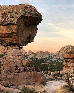
WSierra de Órganos National Park is a national park in Mexico, located in the northwest corner of the municipality of Sombrerete in the state of Zacatecas, near the border with Durango. The park is known for its diverse aridland ecosystem and towering rock formations of the Sierra Madre Occidental, which are reminiscent of organ pipe cacti or the pipes of the musical instrument, from which the park takes its name.
 W
WThe Sierra de San Juan Biosphere Reserve is a protected area in Nayarit state of western Mexico. It was established in 2003, and has an area of 198.01 km2. It lies just southwest of the city of Tepic. It protects a portion of the Sierra de San Juan, a mountain range which lies between Tepic and the Pacific Ocean.
 W
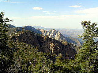
WSierra de San Pedro Mártir National Park is a national park in the Mexican state of Baja California. The Park is part of the municipality of Ensenada, Baja California. The area was first explored by Europeans in 1701 by Eusebio Francisco Kino by Dominican orders.
WThe Sierra de Tamaulipas is an isolated, semi-tropical mountain range in the Mexican state of Tamaulipas. Its highest point is 1,260 m (4,130 ft). There are no cities or towns in the Sierra and the small population is largely agricultural. The higher elevations of the Sierra have forests of oak and pine, contrasting with the semi-arid brush that dominates at lower altitudes. Several archaeological sites establish that the Sierra de Tamaulipas was the northern outpost of the agricultural Mesoamerican peoples of eastern Mexico.
WSierra del Abra Tanchipa Biosphere Reserve is a protected natural area in northeastern Mexico. It is located in the Huasteca Potosina region of San Luis Potosí state, in the eastern foothills of the Sierra Madre Oriental.
 W
WThe Sierra Fría is a mountain range in central Mexico. It forms the northwestern border of Aguascalientes state and extends into adjacent Zacatecas, west of the city of Aguascalientes.
 W
WThe Sierra Gorda is an ecological region centered on the northern third of the Mexican state of Querétaro and extending into the neighboring states of Guanajuato, Hidalgo and San Luis Potosí. Within Querétaro, the ecosystem extends from the center of the state starting in parts of San Joaquín and Cadereyta de Montes municipalities and covering all of the municipalities of Peñamiller, Pinal de Amoles, Jalpan de Serra, Landa de Matamoros and Arroyo Seco, for a total of 250 km2 of territory. The area is extremely rugged with high steep mountains and deep canyons. As part of the Huasteca Karst, it also contains many formations due to erosion of limestone, especially pit caves known locally as sótanos. The area is valued for its very wide diversity of plant and animal life, which is due to the various microenvironments created by the ruggedness of the terrain and wide variation in rainfall. This is due to the mountains’ blocking of moisture coming in from the Gulf of Mexico, which generally makes the east side fairly moist and the west semiarid scrub brush. Most of the region has been protected in two biosphere reserves, with the one centered in Querétaro established in 1997 and the one centered in Guanajuato established in 2007. The Sierra Gorda is considered to be the far west of the La Huasteca region culturally and it is home to the Franciscan Missions in the Sierra Gorda World Heritage Site.
 W
WThe Soto La Marina River or Soto la Marina is a river of northeastern Mexico.
 W
WLake Texcoco was a natural lake within the "Anahuac" or Valley of Mexico. Lake Texcoco is best known as where the Aztecs built the city of Tenochtitlan, which was located on an island within the lake. After the Spanish conquest of the Aztec Empire, efforts to control flooding by the Spanish led to most of the lake being drained.
 W
WThe Volcán Tacaná Biosphere Reserve is a UNESCO Biosphere Reserve at the Tacaná Volcano in Chiapas, Mexico, on the border with Guatemala. The volcano is part of the Central America Volcanic Arc. The 6,378 hectares (24.63 sq mi) reserve contains fragile ecosystems very rich in wild flora and fauna species of cultural, scientific, economic and biological relevance. Its rich biodiversity and high endemism are found particularly in the high mountain ecosystem and landscapes and in the volcanic edifice which presents geophysical features of great scientific and aesthetic value. Average annual rainfall can amount to 2,000–5,000 millimetres (79–197 in), as in the case of Soconusco.